RSFSR Climbing Championship
First Ascent Category 1984

Report
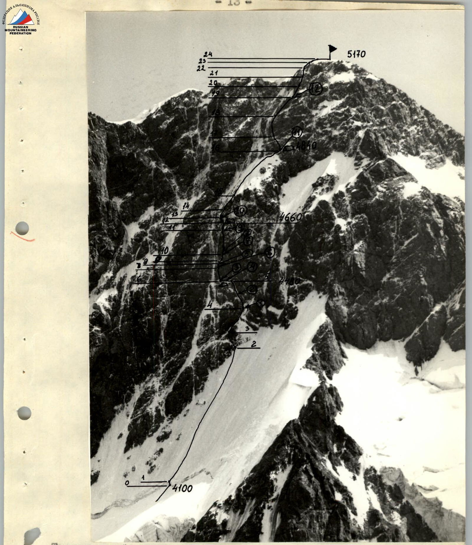
on the ascent of Peak Dzhigit 5170 m via the right part of the North face
first ascent
team from the Krasnoyarsk Regional Sports Committee
Team Leader: Antipin S. M. Coach: Sereda V. A. Gordeev V. I. Mozharov N. P. Pisman M. Z. Senatov S. I. Shlenkin A. K. 18–21/VIII–84
Krasnoyarsk 1984
| Krasnoyarsk | Chairman | Krasnoyarsk |
|---|---|---|
| Regional Sports Committee | Yanovsky Arkady | Ostrov Otdykha |
| Ivanovich | Regional Sports Committee | |
| 36-15-10, 36-49-30 | ||
| Team Leader | Antipin Sergey | Krasnoyarsk |
| Mikhailovich | Krasnodarskaya 15, | |
| apt. 107, 21-53-86 | ||
| Team Coach | Sereda Vladimir | Krasnoyarsk |
| Aleksandrovich | Shchorsa 53, apt. 251, | |
| 21-78-56 |
The altitudes mentioned in the report were determined using an altimeter and a map; the steepness of the route sections was measured with a GK-2 geological compass.

Profile of the wall on the right. Overnight locations marked with altitude 4480 m. Taken on July 27, 1984, at 17:00 after three days of bad weather, "Helios-44" lens, focal length 50 mm, distance to the wall about 3 km, shooting point No. 2.
Team's Tactical Actions
The team worked the entire route on a double rope according to the following scheme:
- the first climber ascends without a backpack on a double rope, secures one rope, and uses the other for belaying the second climber.
- the second climber ascends with top-rope protection using two ascenders and carries the free rope.
- the second climber secures the rope and fixes it at the midpoint so that two climbers can move on one rope simultaneously.
- a second rope is secured parallel to the first, and the 3rd, 4th, and 5th climbers are belayed using a Prusik knot.
- the last climber ascends with top-rope protection using two ascenders.
Rucksack hauling was not planned or executed as it was considered an unnecessary expenditure of energy and time.
The route was chosen to prevent climbers from being directly above one another. There were no deviations from the tactical plan or the chosen route. A rotation of the lead climber was planned:
- sections R0–R6: A. Shlenkin
- sections R7–R15: S. Antipin
- sections R23–R24: S. Senatov
Throughout the route, no daytime stops were planned for the entire group to rest or eat. Each participant was provided with an individual ration.
Tea:
- flasks with 0.8 liters per two people per day were evenly distributed among the group.
Hot meals:
- only during overnight stops.
All overnight stops were planned as sitting or semi-hanging. Ice axes with straight pickaxes were available for creating platforms.
During overnight stops, the team organized:
- fixed ropes,
- everyone slept in helmets,
- with self-belaying.
Although observations suggested the route was not rockfall-prone, an early start was made on the first day. Overnight locations were chosen under the protection of cornices; rockfall-prone sections were traversed one at a time. Belaying and self-belaying were organized reliably.
In case of unforeseen circumstances, the team had studied the descent route along the ascent path.
Since the bastion's rock face was covered with ice in many areas, one climber in the lead rope worked in rubber boots (Vibram, galoshes), while the other wore crampons with ice climbing gear. This allowed for a quick change of lead climber when the terrain changed.
On the fourth day of the ascent, on August 21, 1984, at night, a stormy wind began, and snow started falling. To avoid being stuck for several days, 7 rope lengths from the ridge, they decided to start early and tackle the difficult rocks before they got covered in snow, which they successfully accomplished.
Observers received updates on the group's condition and location via "Romashka" radio every 3 hours; they also frequently listened to the team's intercommunications and continuously monitored them with binoculars.
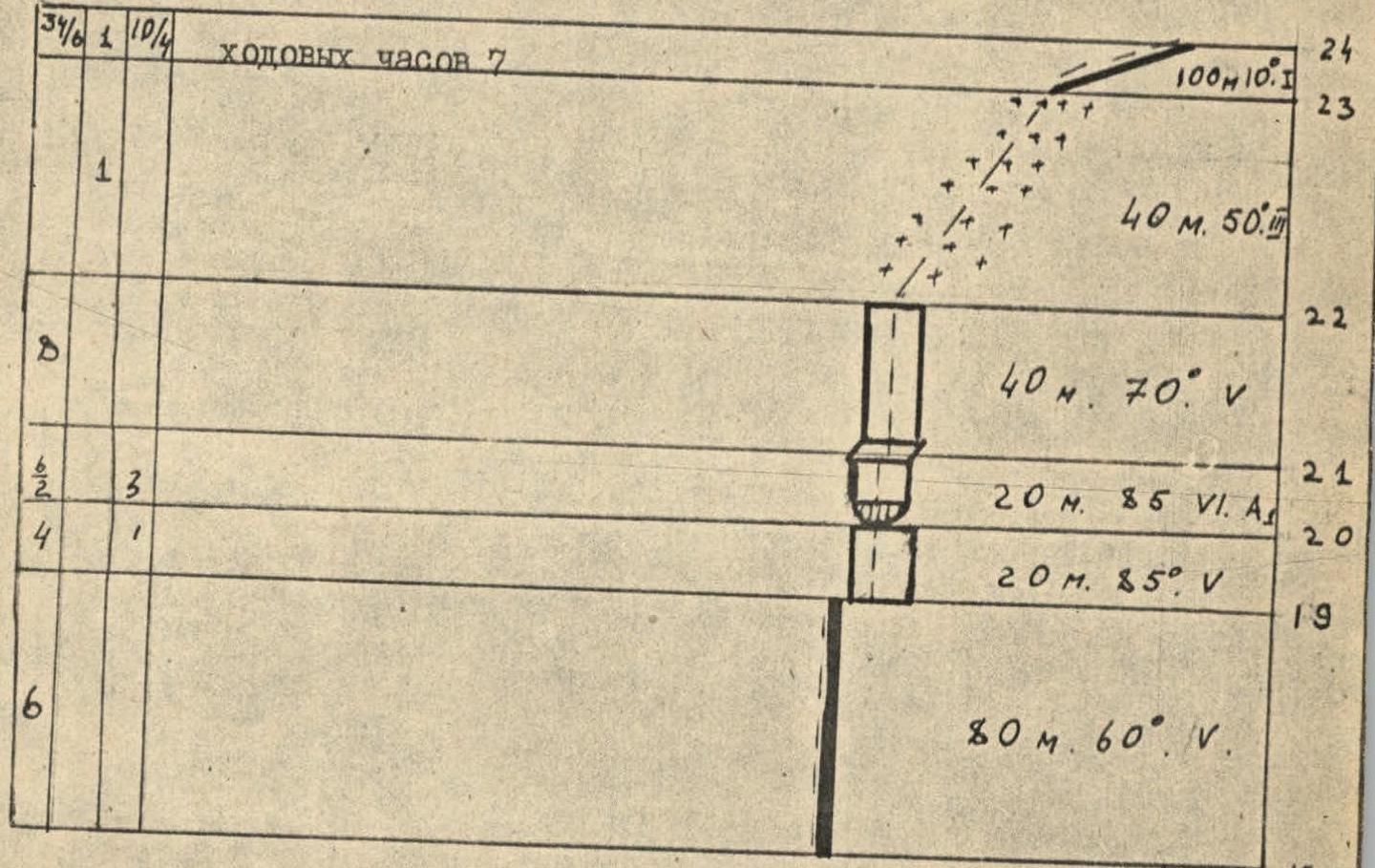
Route Diagram in UIAA Symbols
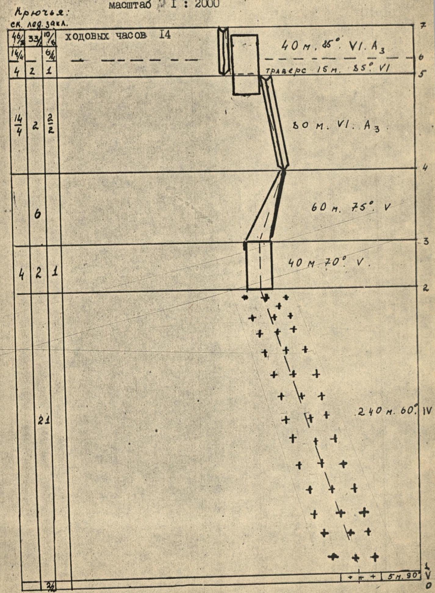
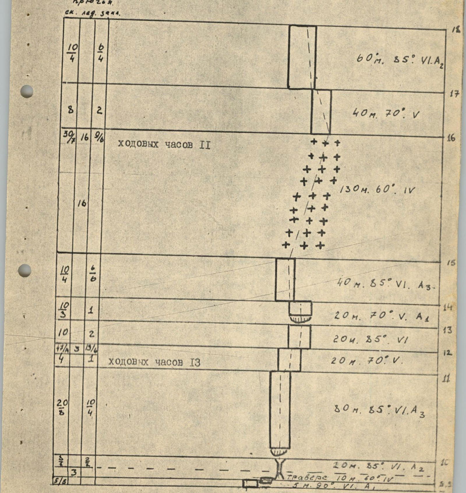
Total climbing time: 45 hours. Total number of pitons: rock 155/43, ice 53/2, protection devices 42/24.
Route Description by Sections
R0–R1 Bergschrund — 2–3 m wide. The upper edge overhangs, complicating passage. Passed with the help of an ice axe and two "Fifi".
R1–R2 Steep ice at 60°. "Fifi" were used during passage.
R2–R3 Ice-covered rocks, "ram's foreheads" type. These are steep rock faces heavily iced. Protection via rock and ice pitons. Live rocks present.
R3–R4 Hard ice with embedded stones. Due to the high steepness, "Fifi" were used extensively. Risk of dislodging thawing stones.
R4–R5 Rocks covered in flow ice, resembling an internal corner. Very difficult climbing. To pass this section, ice had to be chipped away to find suitable cracks for piton placement. Frequently, "Fifi" were hammered into ice-filled cracks.
R5–R6 15-meter traverse of rock covered in thick flow ice. Very difficult climbing. A pendulum swing is possible for the last climber, so pitons with loops must be used to allow the last climber to move on double fixed ropes with subsequent rope retrieval. A control cairn was built on this section. 20 meters below the cairn, there's a ledge suitable for a semi-hanging overnight stop; there are no other convenient spots nearby.
R6–R7 Monolithic internal corner with ice. Few handholds or cracks. Very difficult climbing. Passed using ladders and artificial climbing techniques (ACT).
R7–R8 Vertical five-meter wall. Passed using ladders. Handholds required ice chopping. Very few cracks.
R8–R9 Flow ice on rock, approximately sixty degrees steep. The challenge lies in transitioning from smooth "ram's foreheads" to hard ice. This section ends under a wide internal corner. A pendulum swing is possible for the last climber.
R9–R10 20-meter chimney with smooth, vertical side walls and ice inside. Cracks for chocks and pitons are present. The chimney leads under a cornice. There's a small platform suitable for belay organization; two people can barely fit.
R10–R11 After the cornice, which requires ladder use, a vaguely defined internal corner begins. This is one of the key sections of the route. Very difficult climbing; few handholds, and cracks are often filled with flow ice, smooth rocks. Ladders were used. Live rocks present in the upper part.
R11–R12 Twenty-meter rock wall. Rocks are iced. Live rocks in the upper part can be dislodged by careless movements. After this section, there's a spot to carve out an ice step for a sitting overnight bivouac. Control cairn.
R12–R13 Rock wall. Iced. Ends with a cornice. Ladders were used.
R13–R14 Rock wall. Rocks are covered in flow ice.
R14–R15 This is the most challenging section of the route. A cornice, and above it, a 10 cm wide crack splits the vertical wall. The crack is filled with ice and snow. Movement through the crack is possible using eccentric chocks and ladders; there are no cracks for piton placement.
R15–R16 Hard ice, approximately 60° steep. There's a spot for a semi-hanging overnight bivouac in the upper part.
R16–R17 Section of iced rocks. Handholds require chopping.
R17–R18 Section of steep, heavily fractured rocks. Some areas overhang. Very difficult climbing. Risk of dislodging live rocks.
R18–R19 Rock ridge with sections of ice.
R19–R20 Solid monolithic rocks, practically ice-free. Small handholds. A cornice in the middle section is passed using ACT.
R20–R21 Dry, solid rocks with small handholds.
R21–R22 Uncomplicated snow-ice slope.
R22–R23 Wide snow ridge; cornices on the left.
Technical photograph of the route. Taken on August 15, 1984, at 16:00, "Lyubitel" camera, distance to the wall about 1.5 km, altitude 4400 m, shooting point No. 1.
4480 m — overnight bivouac location marked with altitude (1) photo location marked with photograph number.
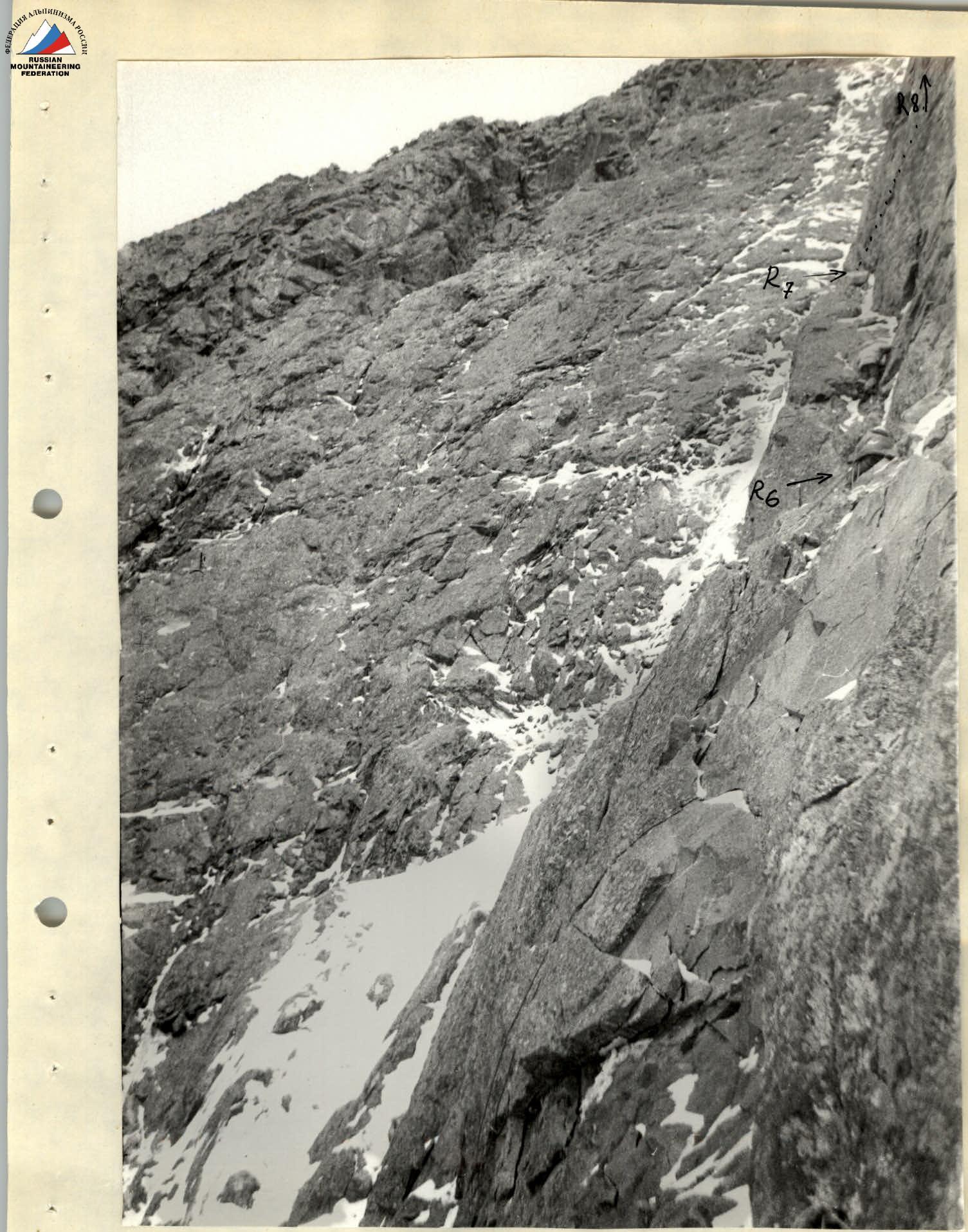
Photo No. 3. Section R6–R7. Processing the section. Taken from point No. 3 on August 18, 1984, at 19:30.
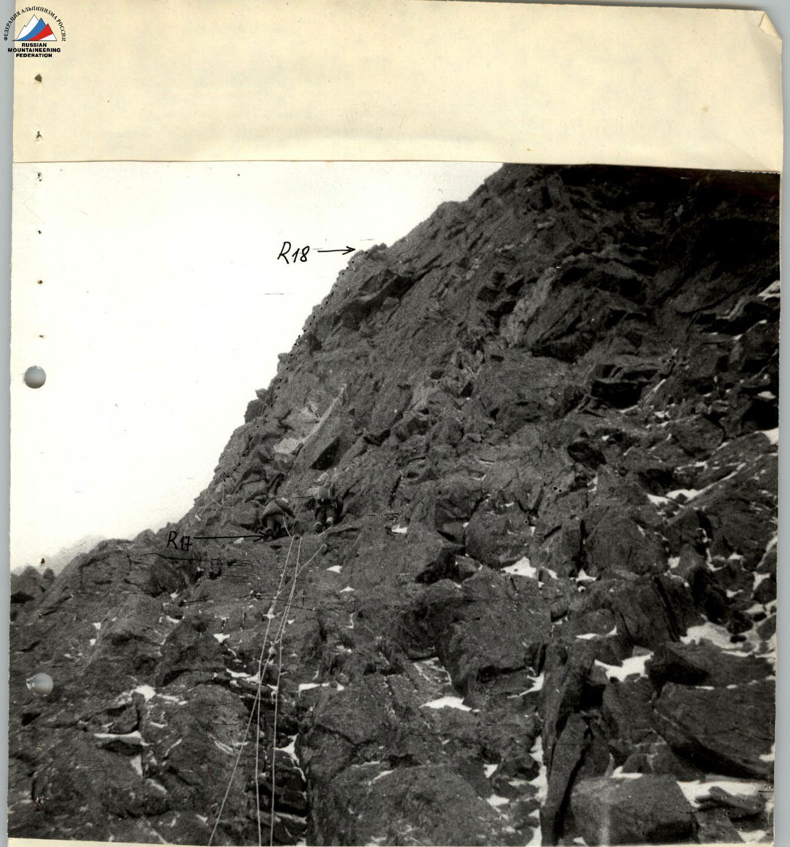
Photo No. 13. Section R17–R18. First rope after the third overnight bivouac. Taken from point No. II on August 21, 1984, at 8:20.