Ascent Passport
Ascent class Technical Ascent area Central Tian Shan Peak, its height Peak Bliukhera, 4850 m Ascent route via N face and N ridge Difficulty category 5B Height difference 750 m Average slope 65° Pitons driven:
- rock 10+3
- ice 0
- bolt 1 Placed cams 20 Climbing time 12 hours Number of bivouacs none
Participants
- Nagovitsyna Elena Yulyevna Candidate Master of Sports, Chelyabinsk
- Afanasyev Alexander Nikolaevich 1st sports category, Snezhinsk
Coach Shestakov Alexander Alexandrovich Candidate Master of Sports, Snezhinsk
Organization Snezhinsk Sports Committee
Date of departure and return July 18, 1998 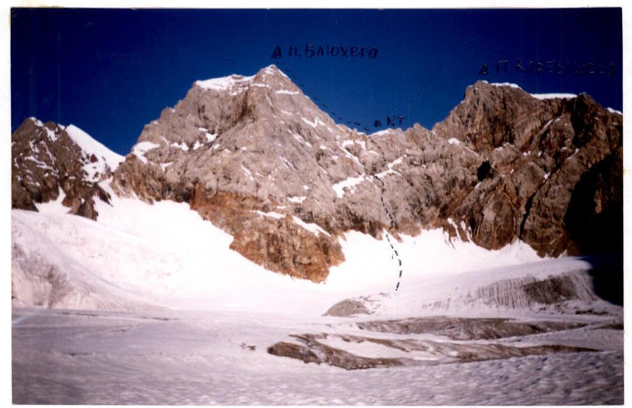
Photo 1. General view of Peak Bliukhera. 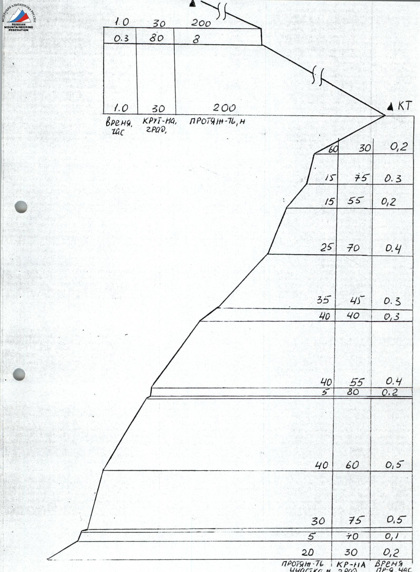
Fig. 2. Route profile.
Tactical Actions of the Team
The ascent took place on July 18, 1998. During the wall part of the route, the first climber worked on a double rope, one of which was dynamic and met UIAA requirements. The second climber moved along the fixed rope with top-rope protection. Due to the dissected terrain along the entire route, cams were mainly used as intermediate protection points. Belay stations were mostly organized using natural features (ledges, flakes, etc.). The wall part of the route consists mainly of III-IV category rocks. The crux sections (category 5) were located on pitches 2, 5, 6, and 12. Afanasyev was the first to work on this part of the route.
The pair reached the ridge around 12:00. At 12:30, the weather suddenly deteriorated, a strong wind blew, and snow started falling. They had to wait for 1 hour, then continued their ascent.
Movement along the ridge rocks of II-IV category was carried out both simultaneously and with alternating protection. In some places, fixed ropes (11-14 m) were used.
Before reaching the summit, they had to overcome:
- a large snow cornice.
Protection here was organized using reliable natural features. The pair reached the summit at 14:00. Nagovitsyna E.Yu. was the first to work on the ridge part of the route.
The descent was carried out via rappel loops in a southeast direction.
The route was completed in accordance with the tactical plan, despite:
- deteriorating weather in the middle of the route,
- significant difficulties in movement due to weather conditions.
Constant radio contact was maintained with the base camp, where a highly qualified surgeon with mountaineering experience and a rescue team were located.
Route Description by Sections
The route starts from a snow-ice cirque between Peak Bliukhera and Peak Karbyshev. One needs to move towards the outcrops of black rocks up a snow-firn slope, the steepness of which does not exceed 30° in its upper part. Before reaching the rocks, it is necessary to cross a bergschrund via snow bridges. The movement along the wall part of the route begins to the right of the black rocks, down which water flows, from a small talus shelf. The route is characterized by free climbing and a logical path.
Along a simple rock shelf to the right and up to a crevice 30 m. Then 5 m up a slab of above-average difficulty. From here, up and to the left along a difficult inner corner 20 m.
Up slabs of above-average difficulty directly 40 m, bypassing a large flake to the right. Then up and to the right along destroyed rocks of average and above-average difficulty to a large horizontal crevice.
From the crevice, up along simple destroyed rocks with many loose stones 60 m to a snow island, and then traverse to the right along wet slabs 20 m. From here, cross the snow island and approach a vertical, not clearly defined inner corner. Then 20 m up the corner along difficult and above-average rocks, and then along slabs to the left and up to a ledge. From the ledge, up and to the left along a difficult vertical flake 15 m, and then 20 m along destroyed rocks of average difficulty up. Along a wide simple ledge 40 m to the right and up, and a horizontal traverse to the left along snowy slabs 40 m to the ridge. On the ridge, there is a cairn.
From the cairn:
- descend into a narrow snow-ice couloir and 20 m up, then to the right onto the ridge;
- along a heavily destroyed, not steep ridge, sticking to the right side, approach a small jendarmerie resembling a brick;
- traverse along rocks of average difficulty to approach a wet vertical wall;
- 8 m up along difficult wet rocks of the wall to the ridge;
- along the ridge 80-100 m along not steep, snowy rocks to a snow cornice, which is bypassed to the right, and then 20 m to the summit.
From the start of the route - 8-10 hours.
The descent from the summit is in a southeast direction along a snowy couloir 80 m down, then 100 m traverse to the right to stationary rappel loops. Two rappels down and then descent along not steep, snowy rocks to the glacier. Along the glacier, sticking to the left side, down to the initial snow-ice cirque, then along the ascent route.