Ascent Passport
I. Ascent Class 2. Ascent Area 3. Ascent Route 4. Ascent Characteristics 5. Pitons Driven: 6. Number of Movement Hours 7. Number of Overnight Stays and Their Characteristics 8. Team Name 9. Full Name of Team Leader, Participants, and Their Qualification 10. Team Coach II. Date of Departure and Return
- Technical
- Tian Shan, Terskey-Alatau
- Peak Blyukhera (4720), East Counterfort.
- height difference –1020 m, average steepness – 70°,
- length of complex sections – 600 m
- rock 109, ice 19 (into rock), bolt 8 (for bivouac).
-
- two: sitting – at the lower part of the tower, good – at the summit
- Team of Oblsoviet DSO "Zenit"
- Zhurzhdin Vladimir Iosifovich, CMS – team leader,
- Ivanchin Ivan Andreevich, CMS – participant,
- Okhrimenko Stanislav Valentinovich, CMS – participant,
- Podymov Evgeny Vasilyevich, CMS – participant.
- MS Penchuk Valentin Lavrentyevich
- 8–11 August 1976
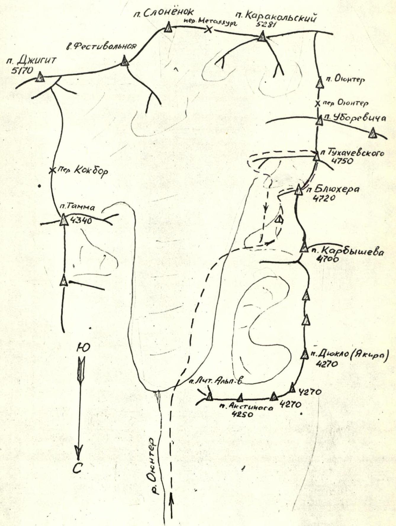
Reference point of the route Oyunter.
Route Description
8 August. Departure from the base camp Ala-Too at 10:00. The path to the summit follows the following route:
- Through the Oyunter gorge to the Karakolsky glacier (4 hours)
- Then on the right (in the direction of travel) side of the glacier to the confluence of the Karakolsky and Karbyshev glaciers
- From here on the right side of the Karbyshev glacier
- Then through its middle part – exit to the snow plateau under the beginning of the route to Peak Blyukhera via the East Counterfort
At 17:00 the group arrived at the bivouac site, set up the tent, and prepared a hot dinner. Once again, they reviewed the entire upcoming route and discussed possible movement options. The frosty clear evening promises good weather, so they decide to get up early at 3:00.
9 August. Early rise, breakfast, and at 4:00 the group heads to the start of the route. The beginning of the route is a 60-meter rock (65°) ascent to a long (35 m) scree-covered snow shelf (R1). Rocks are of medium difficulty. Piton protection.
Along the shelf left-upwards to a vertical chute (with water), turning into an internal steep (up to 60°) corner, ending after 40 m with a stone plug (R2). Pitons for protection are driven into the walls of the corner. Exit to the plug (95°, 5 m) and then right onto a ridge ascent (85°, 10 m). Tense climbing using artificial holds (pitons, ladders) and rope pulls. Then 60 m of a not clearly defined ridge ascent (R3), on both sides of which scree-covered snow shelves require increased attention due to possible falling rocks. Along the rock ascent (70°, 65 m) (R4), the group moves with free climbing and piton protection.
The rock ascent logically leads to a wall (80°, 40 m) having the character of a slab (photo) with a small number of cracks and holds for the front phalanges (R5). It is more convenient to climb this wall in galoshes in good weather. Backpacks are pulled up. In the upper part, the wall turns into a rock ascent, cut through by internal corners formed by large flakes (R6). The ascent ends with a long inclined slab-shelf (30 m), along which the approach to the wall goes left-upwards to the pre-tower ridge (R7). Climbing in this section is difficult (first in galoshes), backpacks are pulled up. Then along the snow-covered ridge (30 m, R8), the approach is made under the base of the tower. A view down from this place gives an idea of the steepness of the path taken. Below, the broken glacier of the cirque is visible (photo). Here is a short stop. A note is placed in a can and hung on a hook driven into a rock corner under a cornice – a "control tour".
The path to the tower initially goes along a huge flake (40 m) with an exit at the top to a narrow snow-covered shelf under a smooth vertical wall. This flake formed a narrow (0.5 m) vertical chimney, in its upper part turning into an overhanging internal corner. Difficult, sometimes forced climbing is complicated by ice covering possible cracks and holds (R9). Psychologically tense is the exit from the chimney onto a snow-covered narrow shelf.
To the right downwards, the smoothed north wall of the peak is visible. Left-upwards, a 60 m vertical smooth wall rises, covered at the top by a rock cornice. This is already the wall of the tower. To climb it directly under the cornice, it is necessary to drive at least 20 bolt pitons.
They decide to apply a different tactic: to go left pendulum-style around the corner of the tower, where a narrow shelf is guessed, encircling part of the tower (R10). Technically, this is done as follows:
- Using ladders, climb slightly left-upwards for 10 m, where 2 duralumin wedges are driven (painted red, left on the wall for future climbers).
- Pendulum-style around the corner of the tower, onto a narrow (1 m) shelf, where the group can gather.
- When the 3rd participant reached the shelf, they began to pull up the backpacks.
- Even more challenging is this pendulum for the fourth, last participant, who will have to knock out all intermediate pitons, reach the wedges, and remove one of the carabiners (the second one also remained on the wall).
But, finally, everyone is gathered, the pendulum rope is threaded through the carabiner, and they can set up a sitting bivouac, especially since they have already been working for 16 hours (R10).
Their shelf consists of two small narrow platforms:
- On one of which, a tent is hung on ropes, in which 3 participants are seated for the night (photo).
- On the other – one person is somehow accommodated for the night.
Everyone is attached to the taut ropes.
10 August. The weather on this day is on their side, which is quite rare in this area, throughout the ascent. Early morning raises them not entirely rested but quite refreshed and vigorous. From the meager snow reserves lying on the shelf and collected by them (photo), they boil tea, have breakfast, and already at 5:30, the first person, again in galoshes, starts processing the overhanging wall of the tower.
The movement upwards begins to the left of the shelf along the smoothed external corner of the tower (R11). For protection, it is immediately necessary to drive a bolt piton. The sheer wall after 10 m overhangs, throwing off those climbing. Fortunately, such "acrobatics" after 20 m is interrupted by a small shelf, on which 2 people can barely fit, pull up, and hang their backpacks on the wall.
Up to the top of the tower (R12), such "acrobatics" are repeated 4 times, with the only difference being that the relief of the sections being climbed changes from an external overhanging corner to an overhanging chimney (on R3) and a rock cornice (on R4). The tower "justified" their expectations – the difficulty of climbing here is on par with the most complex sections of Crimean rock routes.
At 12:30, thanks to the clear and coordinated work of the participants, the last one in the group climbs onto the tower. Here, they can change their shoes and rest a bit.
Then the group, changing the lead, moves along the steep ridge (up to 75°) towards the summit of Peak Blyukhera. The path goes along snow-covered shelves to the left of the ridge (R13), a steep ascent (R14), along which the participants in two rope teams follow parallel routes to the ridge of the counterfort (R15) and along it – to Peak Blyukhera. Here – a control tour, left by the collection group led by V. Penchuk, who completed the traverse of the peaks Karbyshev – Blyukhera – Tukhachevsky.
300 m from Peak Blyukhera along the ridge is Peak Tukhachevsky – a summit, where 10 m down on the descent under a large overhanging rock, it is convenient to set up a bivouac.
11 August. Descent from Peak Tukhachevsky to the southeast along the route 4A cat. diff., then along the Karbyshev glacier, through the Oyunter gorge – to the base camp "Ala-Too". The total duration of the route is 4 days.
Table of Main Characteristics
Ascent Route: Peak Blyukhera via East Counterfort
| Sections Covered | Average Steepness of Section (degrees) | Length of Section (m) | By Relief Character | Category of Difficulty | By Method of Overcoming and Protection | Weather Conditions | Time of Stop at Bivouac, Departure, Movement Hours | Rock | Ice | Bolt | Bivouac Conditions |
|---|---|---|---|---|---|---|---|---|---|---|---|
| Approach to Route | 19:00–20:00, 4:00 | 3 | 1 | – | |||||||
| R1 | 65° | 60 | Rocks, internal corner | 3–4 | Free climbing, pitons | good | 3 | 1 | – | ||
| R2 | 60° | 75 | Shelf, chute, internal corner, plug | 4–5 | Free climbing, pitons, ladders | – | 15 h 42 min | 10 | 1 | – | |
| R3 | 60° | 90 | Wall 10 m, rock ascent | 5–4 | – | – | 6 | 2 | – | ||
| R4 | 70° | 80 | Wall, rocks, flakes | 4–5 | Ladders, pitons | – | 9 | 0 | – | ||
| R5 | 80° | 60 | Slab character | – | – | – | 11 | 2 | – | ||
| R6 | 75° | 90 | Rock ascent, flakes | 4–5 | Free climbing, pitons | good | 12 | 3 | – | ||
| R7 | 85° | 95 | Rocks, slabs, external and internal corners | 5 | Artificial holds, pulling, pitons | – | 15 | 3 | – | ||
| R8 | 40° | 30 | Snow-rock ridge | 3 | Simultaneous protection | – | 4 | 1 | – | ||
| R9 | 90° | 40 | Internal corner of wall, chimney | 5 | Artificial holds, ladders, pulling | – | 6 | 2 | – | ||
| R10 | 90° | 40 | Smooth wall | – | Pendulum, ladders | – | 10 | 2 | – | ||
| R11 | 95° | 40 | Wall, external corner | 5 | – | – | Start of bivouac: 19:10, departure: 5:30 | 8 | 2 | 4 | |
| R12 | 95° | 50 | Rocks, cornice | 5 | – | – | 13 h 40 min | 9 | 2 | 2 | |
| R13–R15 | 70° | 260 | Rock ridge, ascent, snow-covered shelf. Summit. Descent | 3–4 | Free climbing, pitons. Descent | – | 8 | – | – |
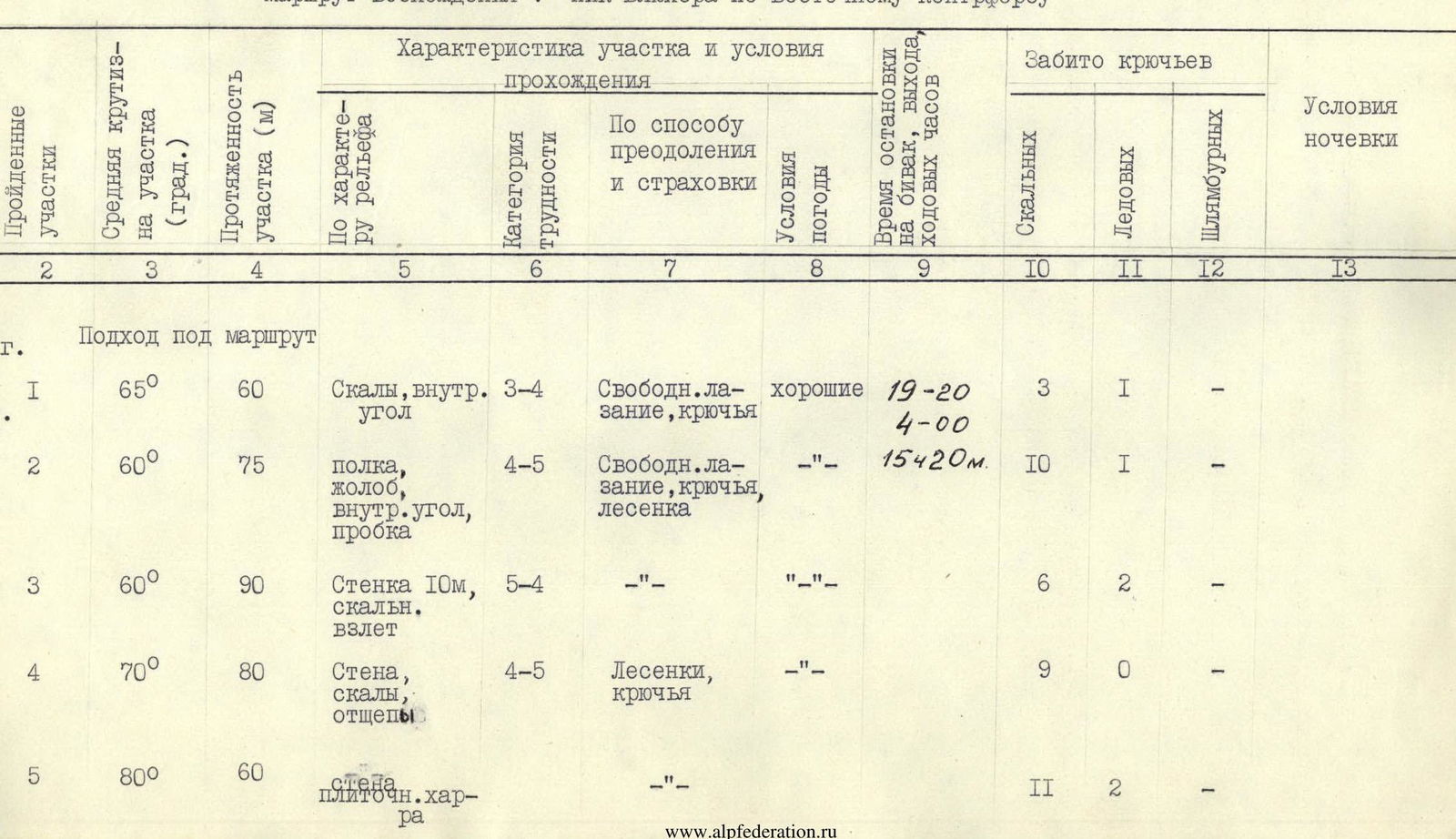
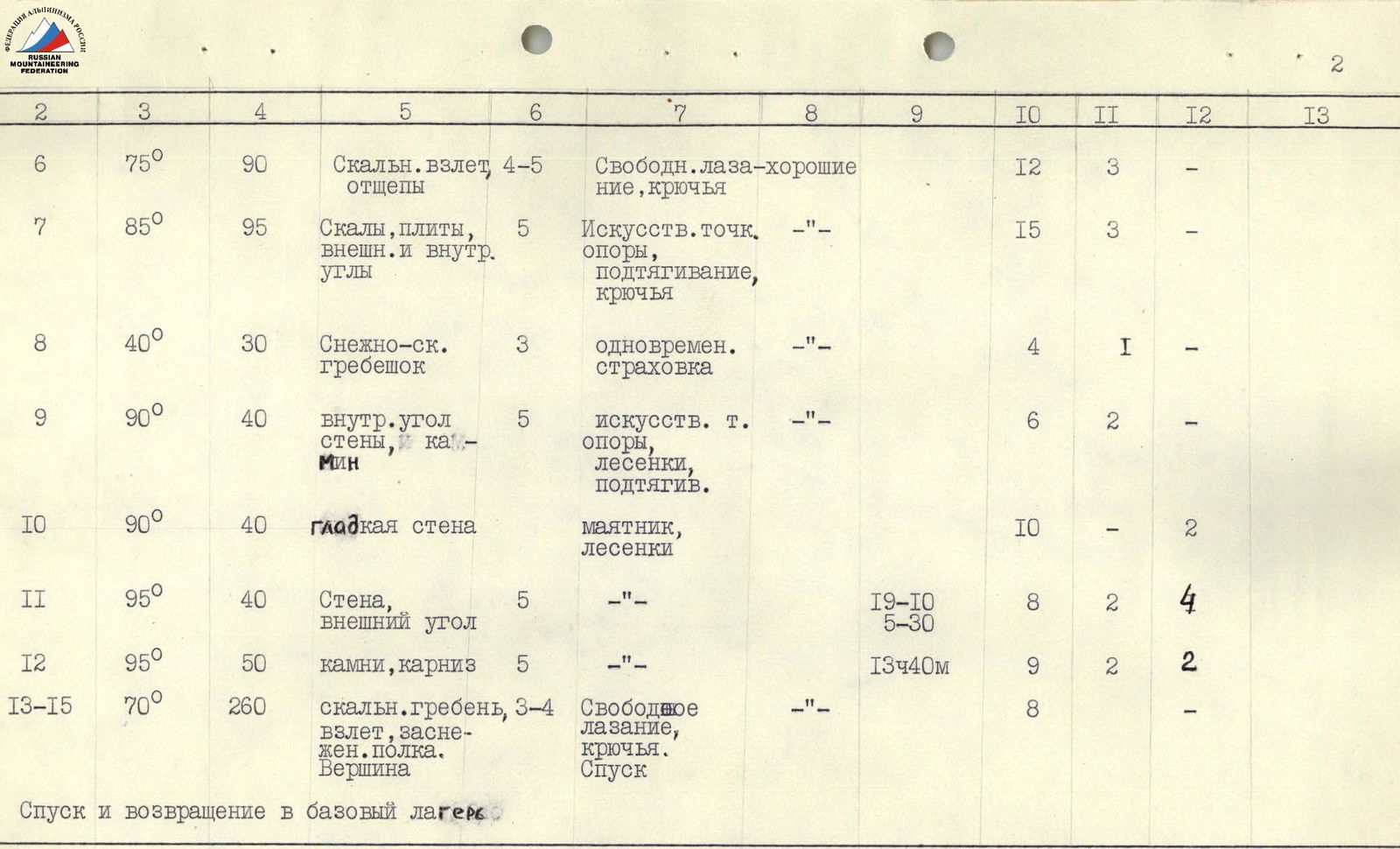
Note: Ice pitons were driven into rocks in places of upper protection organization.
Team Captain: (V.I. Zhurzhdin)

Peak Blyukhera (4720), East Counterfort. Route traversed by the team of Oblsoviet DSO "Zenit". Route ~4A cat. diff. to p. Tukhachevsky (4750).
Evaluation of the Route Traversed
The route traversed to Peak Blyukhera (4720 m) via the East Counterfort refers to technically complex ascents, differing from existing combined routes in the area of the highest category of difficulty – by its rock character and technical complexity for passage. The route is logical, safe from rockfall. Considering the experience of the ascents of the highest cat. diff. completed by the participants and comparing the route with those given below, the participants believe that the route traversed corresponds to 5B cat. diff.
Experience of Technical Ascents of Participants
| Dalar peak, NE edge | 5B |
|---|---|
| Passionarii peak | 5B |
| Uilpata | 5B |
| Mamison-khokh | 5B |
| Krumkol | 6 |
| Western Dombay via st. TsDSA | 5B |
| Eastern Dombay from S. | 5B |
| V tower of Corona | 5B |
| VI tower of Corona | 5B |
| Dzhigit peak via N. st. | 5B + 1 |
| and others |

Peak Blyukhera (4720), East Counterfort. View from p. Karbyshev