Ascent Passport
I. Ascent class — rock climbing 2. Ascent area, range — Tian Shan, Terskey Alatau 3. Peak, its height, ascent route — p. Ashutor, 4020 m, from Ashutor Pass 4. Proposed difficulty category — 2B combined 5. Route characteristics:
- elevation gain — 350 m
- length of sections, difficulty category: 1 — 200 m 2 — 200 m 3 — 100 m 4 —
- average steepness
- Pitons hammered:
- for belay, for creating artificial holds:
- rock pitons — 6
- ice screws —
- bolt pitons —
- Duration of ascent — 5 hours
- Number of nights and their characteristics — none
- Surname, name, patronymic of the leader, participants, and their qualification Leader: Fedyaev A.L., 1st sports category Participants: Bochkov V.V., 1st sports category Zarutsky A.G., 1st sports category
- Team coach Ryabukhin A.G., Honored Coach of the RSFSR
- Date of departure and return — August 12, 1982
General photo of p. Ashutor 4020
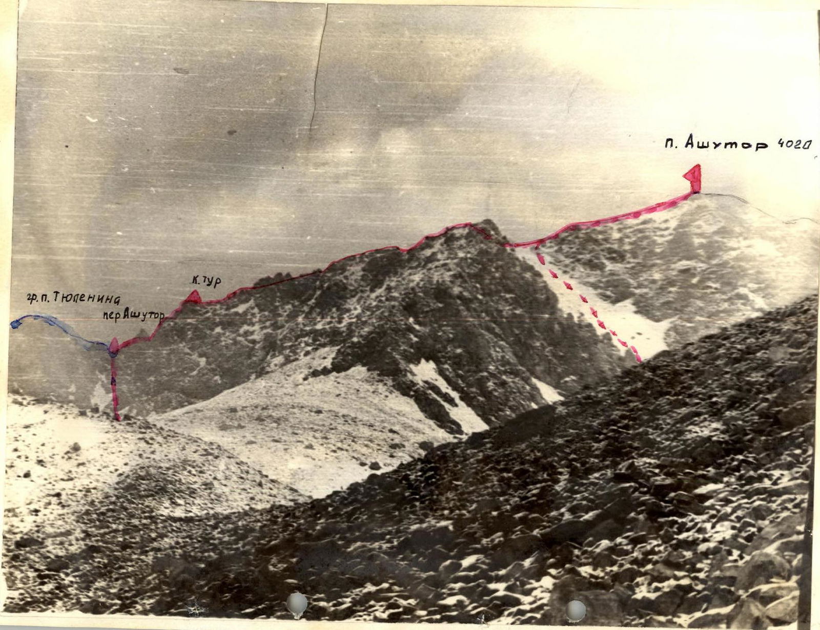
p. Ashutor 4020
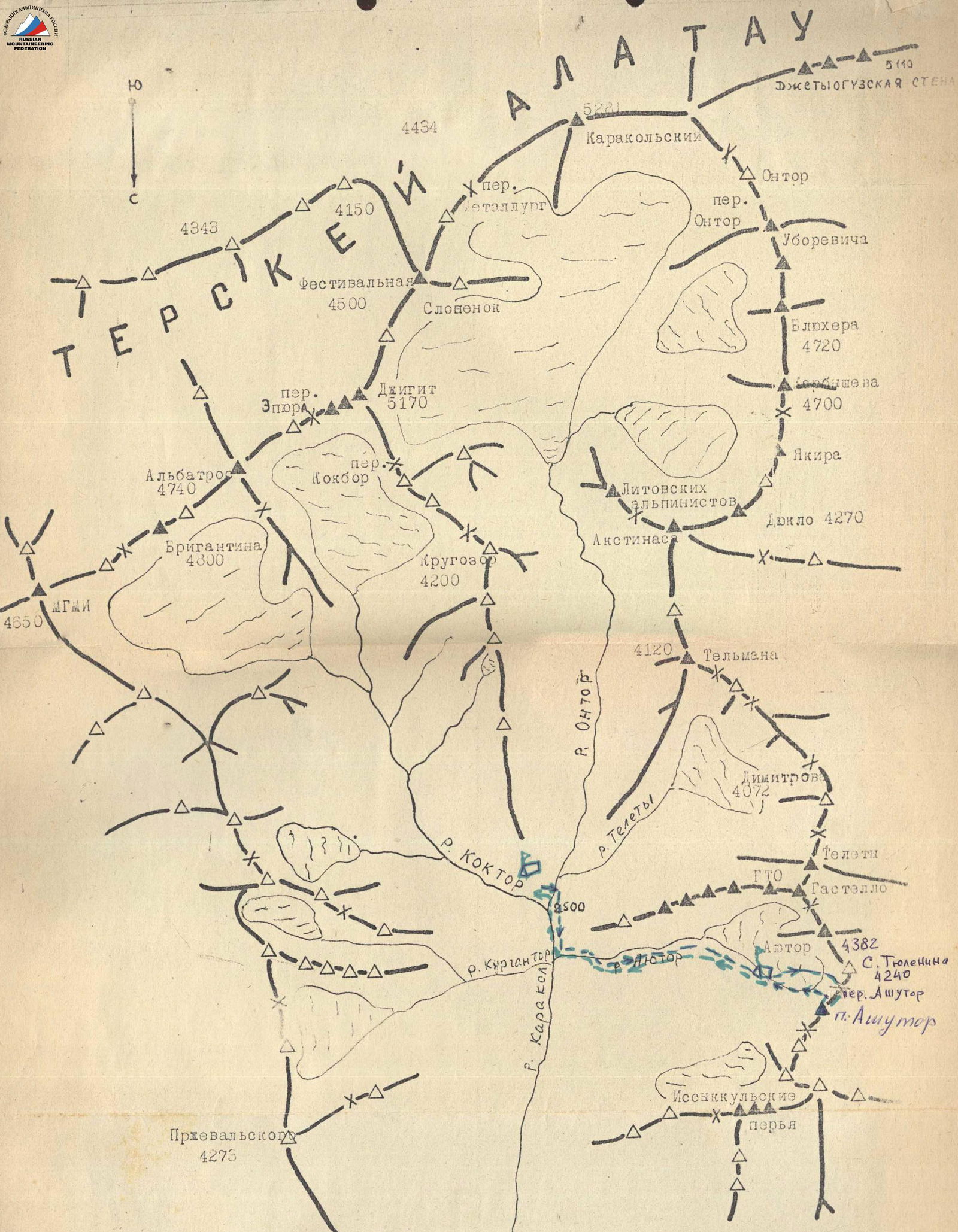
Description of the approach to the start of the route
From the base camp at the confluence of the Ontor and Kokbor rivers, we move along the road downstream along the Karakol River to the mouth of the Ayutor River. We cross the Ayutor stream by bridge.
Then we move up the Ayutor valley on the right side. Good trail. Before p. Ashutor, we turn right and ascend to a moraine lake via a trail. Here we set up a bivouac. Travel time is 3–4 hours.
From the bivouac, following the left part of the moraine, we approach the slope of p. Tyulenina and move along it to per. Ashutor. Travel time is 1.5 hours.
Route description, 2B category (approximately), combined route on p. Ashutor via the SW ridge from per. Ashutor
At the pass, there is a control cairn.
Section R1–R2: A destroyed rock wall, about 50 m, with a steepness of 50–60°. Climbed with piton belay. In the upper part of the rock, there are smooth holds for about 5 m — exit to the ridge, category 3.
Section R2–R3: From the cairn — a destroyed ridge, about 50 m, steepness 25°.
Section R3–R4: A gendarme. Bypassed on the right via slabs and destroyed rocks, about 40 m, 45°, category 3. Loose rocks!
Section R4–R5: A destroyed rock ridge, about 50 m. Simultaneous movement, 35°, category 2.
Section R5–R6: Descent into a gap, 15 m. Via free climbing.
Section R6–R7: From the gap, exit left along an internal corner filled with snow, onto the ridge, about 6 m, 45°, category 3.
Section R7–R8: A destroyed ridge, 100 m, category 2.
Section R8–R9: Descent onto a snow saddle via free climbing, about 20 m. Loose rocks.
Section R9–R10: A snow saddle. Caution, cornices! 20 m, category 2.
Section R10–R11: A destroyed ridge, about 150 m. Exit to the summit.
Descent: Returning to the snow saddle and descending via scree on the SE slope to the moraine, on the left (in the direction of travel) side of the moraine, to the camp.
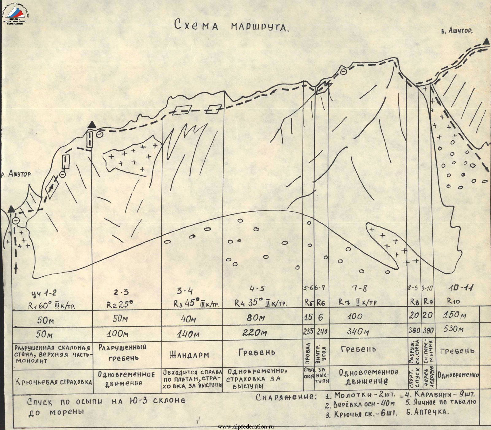
Route scheme
p. Ashutor.
