Ascent Passport
-
Ascent category
-
Ascent area: Tian-Shan, Terskey-Alatau
-
Ascent route with indication of peaks and their heights: p. Zap. Albatros via SW ridge through p. Epyura
-
Ascent characteristics:
height difference 1010 m
length of complex section
average steepness
-
Pitons used: rock 4, ice, bolted
-
Total hours on the move: 8 h
-
Number of bivouacs and their characteristics
-
Team name
-
Surname, first name, patronymic of the leader, participants, and their qualification: Myasin Yuri Alexandrovich — 1st sp. category, Osipov Konstantin Viktorovich — 1st sp. category, Bektyakov Vladimir Ilyich — 1st sp. category, Iskhakov Albert Saidovich — CMS
-
Team coach: Raspopov S. A.
-
Dates of departure and return: June 29, 1975
Technical description of the route
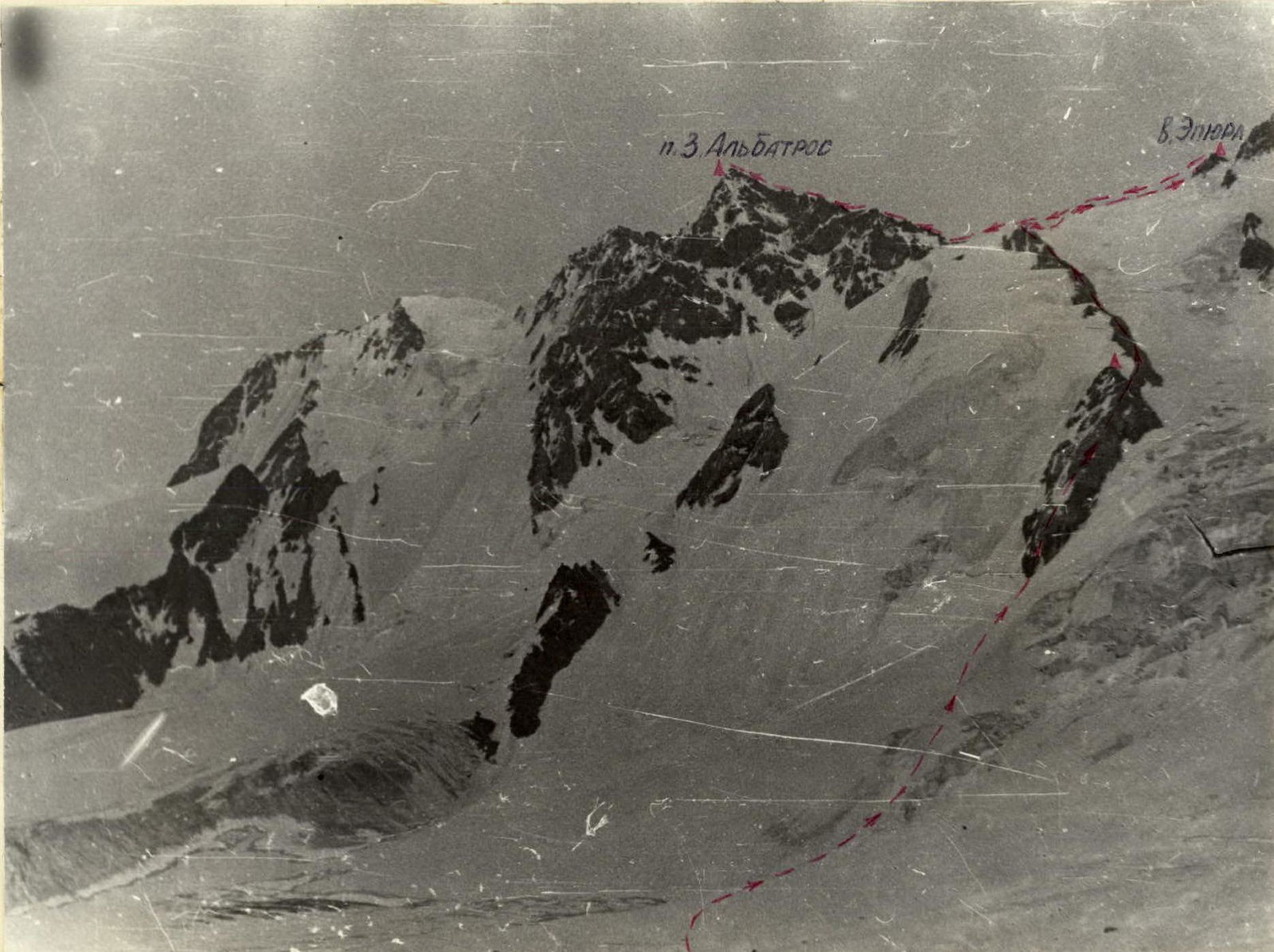
From Dzhigit Glacier, along a snow-ice slope, leaving the icefall to the right, one needs to approach the beginning of the rocky ridge. Along the destroyed rocks of medium difficulty (pitons used for belay!), ascent — two ropes (60 m). The next section of the route along a narrow and more gentle ridge — three ropes (pitons used for belay in places!) leads to the upper point of the first stage of ascent to peak Epyura. A sharp snow ridge, gentle with gradually increasing steepness (small cornices in places!) leads to the second stage. From here, descent into a small cirque and ascent along a sharp snow ridge to p. Epyura. Descent from the peak in the direction of p. Albatros along simple rocks onto a wide snow ridge and along it, one needs to approach the rocks of the southwest ridge of p. Albatros. Simple destroyed rocks lead to the first gendarme, which is overcome "head-on" (belay!). Then the ridge narrows, becomes more jagged (90 m). Another two or three ropes of simple ridge and we approach the red gendarme, which is also passed "head-on" (belay!). From it, descent into a gap of about 8–10 m. After that, two black gendarmes follow in succession. They need to be bypassed on the right along the way (50 m) (belay!). Further, the ridge expands somewhat. After about 60–80 m, we come out onto a sharp snow ridge (cornices!). Movement along this ridge is 30 m. Then another 60 m of expanding destroyed ridge with snow and we come out onto p. Albatros. The peak is not sharp — the whole group can fit freely.
Descent is made along the ascent route.
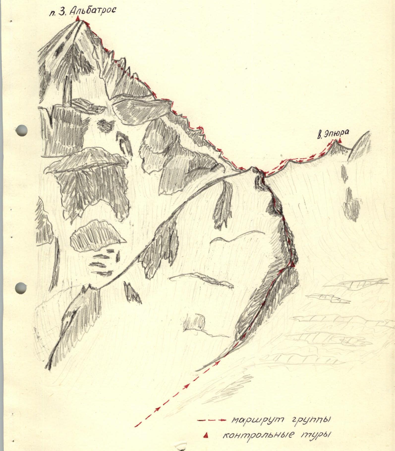
p. 3. Albatros p. Epyura group's route control cairns
Description of the route passage
June 29, 1975. 7 am. The sky is clear — it seems we're lucky with the weather, but over Issyk-Kul, as always, it's dark.
Our foursome is ready for the ascent, standing near our backpacks. The releasing coach, S. A. Raspopov, scrutinizes us from head to toe, checks the equipment before signing the route sheet.
We receive final instructions: interaction with V. Pashchenko's group, which has already started on the route 4B cat. diff. to p. Albatros. Communication is visual and vocal. Pashchenko's group has a "Vitalka" radio station to communicate with the observation group, which observes our bivouac site and the team of masters going along the route p. Dzhigit — center of the north wall. The observation group has communication with the base camp.
7:20. We're already walking on Dzhigit Glacier. The night was warm, so the firn doesn't hold well — we sink in sometimes up to our waists. We move in rope teams: Myasin — Osipov, Iskhakov — Bektyakov.
8:30. We approach a snow slope (steepness up to 45°). We rest for 10–15 minutes and continue. In some places, we have to cut steps — ice is close to the snow surface. Another 15–20 min — and we're on the rocks. The rocks are destroyed — many cracks, it's easy to climb, but for reliable belay, we sometimes have to hammer in pitons. At the top of the first rocky ascent, we build a control cairn.
After the first section of rocks, we come out onto a narrow rocky ridge, turning left. It's more gentle, we mostly move simultaneously, but in one place, a section of rocks is covered with ice crust — we had to hammer in one piton.
From the first stage of ascent, we turn right along a snow ridge towards p. Epyura. The ridge is gentle, but quite sharp, with small cornices in places. We have to move carefully — belay via ice axe. Along the ridge, we come out onto a short section of simple rocks, and along them to p. Epyura.
10:20. We build a cairn, leave a note. The weather gradually worsens. Dark clouds, which were peacefully dozing over Issyk-Kul, have covered the sun. Along the snow, we approach the southwest ridge of p. Albatros. Simple destroyed rocks lead to the first gendarme, which is easily overcome "head-on" — belay via ledges. Further, we pass three ropes of a sharp jagged ridge, climb onto a low red gendarme, and descend into a gap (8–10 m) — belay via ledges. We bypass two black gendarmes on the right along rocks and partly along snow with belay and come out onto an expanding simple rocky ridge. After two ropes, a sharp snow ridge begins, we move with caution — there are small cornices. Another two or three ropes, we move simultaneously along a simple ridge. 13:00. We're on peak Albatros. We decided not to linger here for long. Low cloud cover — the panorama is almost entirely closed. We rested for 15 minutes, wrote a note, and began to descend along the known path.
About an hour passed, on the last rope of Albatros ridge, we're thoroughly caught in bad weather. Snow, wind — a real blizzard. Visibility — no more than 10 m. We stood for a while, waited — maybe it will clear up. In vain. We quickly set up the tent — it's with us on any Tian-Shan ascent. We sit in its cozy microclimate and enjoy our planned rations. We had to wait for an hour and a half for the snow charge to pass. First, "windows" appeared, and by the time we took down the tent, the path was open. Another couple of hours — and we're already standing at the bivouac site, shaking hands with friends from the observation group.
Ascent completed
On the route, four rock pitons were used.
0