Ascent Passport
I. Ascent class — technical 2. Ascent area — Central Tien-Shan, Terskey Ala-Too ridge, Jety-Oguz gorge 3. Peak — Peak 4062 m, ascent route — via the North ridge 4. Estimated category of difficulty 2A 5. Route characteristics: height difference — 593 m. Length of sections of II–III category of difficulty — 870 m. Average steepness 46° 6. Pitons hammered: for belay: rock — 4, ice — 2, bolted — 0 7. Number of climbing hours — 8 8. Number of nights and their characteristics — 0 9. Surname, name, patronymic of the leader, participants, their qualification: ZAVARZIN Yuri Timofeevich — leader, 2nd sports category; BELNITSKAYA Galina Ivanovna — participant, 2nd sports category; CHERNOVA Svetlana Anatolyevna — participant, 2nd sports category. 10. Team coach — BIRYUKOV V.N. 11. Date of departure on the route — July 23, 1978 date of return from the route — July 23, 1978
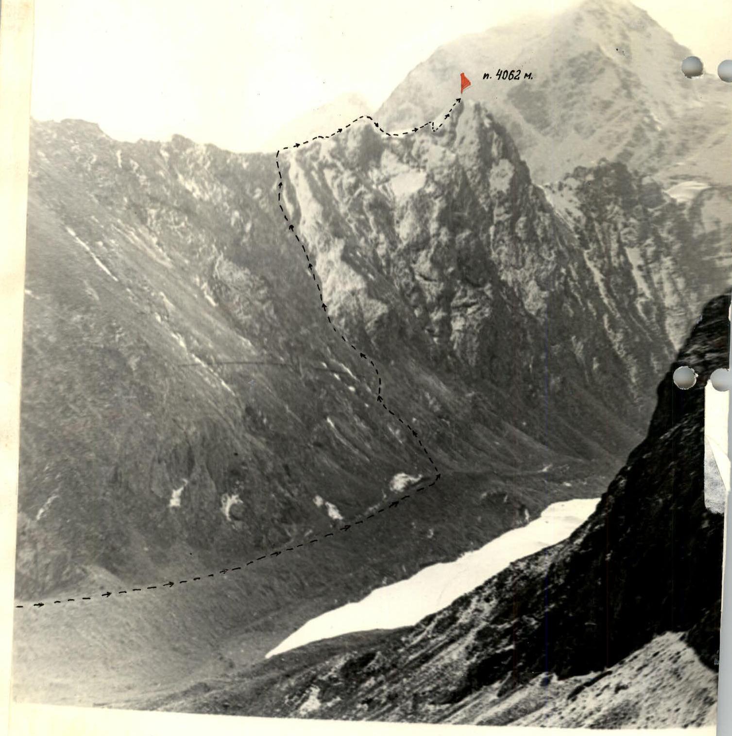
Peak ZAPADNAYA OGUZ-BASHI 5080 m. Peak 4062 m.
Brief description of approaches to the route
Peak "4062" — 4062 m (the height of the peak is given based on a topographic survey of scale 1:100 000, edition … year). Located in the northern spur of the watershed ridge Terskey Ala-Too above the source of the left component of the Jety-Oguz river — Baytor river, in the right part of the Baytor gorge (see map).
From the city of Przhevalsk by bus to the Jety-Oguz resort, further along the Jety-Oguz gorge to the Telety gorge by road. Then on foot up the gorge to the fork to the Baytor gorge. Cross the Jety-Oguz river by ford to the left bank, then along a log to the left bank of the Baytor river at the fork. It is possible to cross the Jety-Oguz river at the Telety camp. Along the Baytor gorge to the fork, then along the left bank of the Baytor river rise to the Baytor camp.
From Telety to Baytor camp:
- movement is everywhere along the horse trail and tourist trail;
- travel time — 4–5 hours with full backpacks.
The camp has clean water, and there are good grassy areas. The route is not visible from the Baytor camp.
From the camp:
- through the left tributary of the Baytor river we go to the moraine inclined dumps of the unknown ridge;
- traverse them, rising up the gorge;
- cross the right arm of the Baytor river by ford;
- rise up the loose slopes of the gorge.
The route is accessed by a scree. The approach time is:
- 2 hours by car;
- 7–8 hours to the route.

Table of main characteristics of the ascent route
Appendix No. 2
July 23, 1978
| Section designation | Average steepness in degrees | Length in m. | Character of relief | Difficulty | Condition | Weather conditions | Rock | Ice | Bolted | Exit to the route |
|---|---|---|---|---|---|---|---|---|---|---|
| R0–R1 | 30–40° | 400 | Scree couloir | I | Live scree | Variable cloudiness | Exit from camp 05:00 Exit to route 08:00 | |||
| R1–R2 | 30–50° | 400 | Ridge | II | Destroyed rocks | 0/10 | ||||
| R2–R3 | 30° | 200 | II | Snow, ice | 2 | |||||
| R3–R4 | 55° | 200 | II | Gendarmes, rocks | 2/6 | |||||
| R4–R5 | 80° | 10 | Wall | III | Soft snow, loose rocks | Belay on an outcrop | ||||
| R5–R6 | 60° | 60 | Wall | III | 2/6 | Reach the summit 16:00 Descent via the ascent route | ||||
| Total | 1270 | 4/23 | 2 | 0 |
Average steepness 46°. Length of sections of II–III category of difficulty — 870 m.
Notation: numerator — rock pitons, denominator — outcrops.


