Report
on the ascent of Oguz-Bashi 2nd Eastern via the Northern wall, 5B category of difficulty, second ascent.
Team of Tomsk Regional Sports Committee.
Team captain — Sannikov Yu.V. Team coach — Dyachenko N.N.
634050, Tomsk, Herzen St. 8, Regional Sports Committee. 634055, Tomsk, 30 let Pobedy St. 3, apt. 606, Sannikov Yu.V. 634012, Tomsk, Kirova St. 61, apt. 30, Dyachenko N.N.
The heights and steepness of the route are marked according to the data of the USSR Sports Committee (laser survey).

Time schedule of the ascent

Protocol
of the ascent of Oguz-Bashi 2nd Eastern via the Northern wall (route by V. Tenenev), 5B category of difficulty, second ascent, made by the team of Tomsk Regional Sports Committee on July 16-17, 1986 (the ascent was made as part of the 1986 RSFSR Youth Alpine Climbing Championship, ice and snow class).
Present:
- Participants of the ascent: Sannikov Yu.V. — leader Sviridov A.A., Solomatov V.N., Pavlov I.L.
- Releasing coach of the team Dyachenko N.N., Master of Sports, instructor category II.
- Head of the rescue team — Korzunin Yu.K., Candidate Master of Sports, instructor category II.
- The entire composition of the training camp.
Speeches: Sannikov Yu.V. — "Initially, we planned to ascend via the route by E. Darmin on Oguz-Bashi 3rd Eastern, but it turned out to be avalanche-prone at that time due to prolonged bad weather. Moreover, the head of the regional climbing camp, Kuzmenko B., provided us with all available materials on the Djety-Oguz valley and did not recommend this route for the same reason. Therefore, we chose Oguz-Bashi 2nd Eastern via the route passed by V. Tenenev's group as part of the 1984 USSR Championship in the ice and snow class."
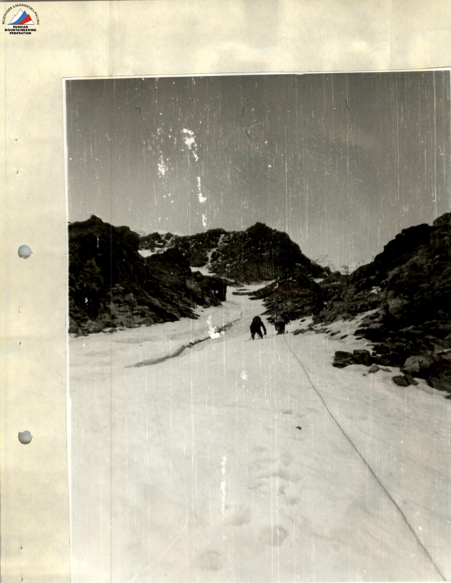
Time breakdown of the ascent: the group left the observer's camp on the right lateral moraine of the glacier (orographically) on August 16, 1986, at 4:30. At 6:00, they approached the start of the route. The route begins with a 250-meter ice couloir with a steepness of 45°. In the upper part, the couloir gradually widens, becomes steeper, and turns into an ice board. Having passed the couloir, the group reached the ice board with a length of about 350 m and a steepness of 55° at 9:00.
Above the board, there is a belt of rocks covered with ice, followed by an ice-snow slope with a steepness of 50°, leading to the ridge. The group approached the rocks at 16:00. At 20:00, the group reached the ridge.
The ridge is represented by snow fields going in undulations all the way to the summit, with an average steepness of 45°. They set up a tent on the ridge and built a windproof wall out of snow. The weather was good all day — clear and windless.
On August 17, at 8:00, they continued their ascent. At 9:30, the group reached the summit in full. In the cairn, they found a note from the first ascenders led by Tenenev, consisting of 4 people, dated August 13, 1984 (Novosibirsk, SA and VMF).
At 10:00, they began their descent towards the 1st Eastern Oguz-Bashi peak. Here, they had to gain another 100 m in height. Traversing the ice slopes of the 1st Eastern, at 13:00, they reached the Chelyabintsev Peak, also located on the main ridge.
Following Chelyabintsev Peak, an ice couloir begins from the ridge, leading to the glacier. At 20:00, the group descended to the glacier, 30 minutes' walk from the observer's camp. The weather remained stable on the second day of the ascent.
Communication with the observer group and the coach was carried out via a "Transport" radio station at 8:00, 12:00, 16:00, 20:00, and, if necessary, during additional listening hours — at 10:00, 14:00, 18:00, 22:00.
Tactics of the ascent: on the route, they worked in pairs:
- Sannikov Yu.V. — Pavlov I.L.
- Sviridov A.A. — Solomatov V.N.
Throughout the route up to the ridge, they used ropes with insurance through ice screws and rock pitons. On the ridge, they ascended to the summit in autonomous pairs. When working on the wall:
- The first climber worked on a double rope;
- The others ascended via the ropes using "Jumar" devices;
- Insurance stations were organized from two linked ice screws, and on rocks, from three insurance points;
- Equipment was passed along the chain from the last to the first.
The entire route was traversed in crampons — 3 pairs of 18-tooth (homemade, similar to American "platforms") and 1 pair of 12-tooth VTsSPS. The first climber also used a pair of ice axes, which accelerated the group's movement. Throughout the route, everyone climbed with backpacks. The lead climber was changed once on the wall — approximately halfway up the ice board; first, Pavlov I.L. led, then he was replaced by me.
All participants knew each other from joint ascents in the current and previous seasons, having climbed routes of 5A category of difficulty together, so they worked in harmony, and no conflicts arose. Each knew the capabilities of the other team members from joint training sessions in Tomsk. They all demonstrated good physical and technical preparation. There were no delays in handing over the ice screw to the first climber. The quick and reliable work of Pavlov I.L. on the ice is worth noting. They approached the organization of the ascent seriously, including:
- Selection of equipment;
- Selection of food;
- Development of a tactical plan.
The successful passage of the route was a result of good preparation.
Sviridov A.A. — "This is my first route of 5B category of difficulty, just like Solomatov and Pavlov. Of course, it's more challenging than the routes I've done before (e.g., 'Sphinx' on Chaptar). I believe we passed it reliably. I'm satisfied with my teammates; they're all well-prepared. The captain handled his responsibilities well."
Pavlov I.L. — "I liked the route. It corresponds to the 5B category of difficulty. The group's composition was even; each participant performed their functions confidently and reliably. The insurance did not raise any concerns throughout the route, especially when organized by Sviridov."
Solomatov V.N. — "I really liked the route; it's the most challenging and beautiful one I've done. I've climbed with all the participants before, including on previous category routes. I'd like to climb with this team again."
Korzunin Yu.K. — "Were there any deviations from the tactical plan, and what were they motivated by?"
Sannikov Yu.V. — "The upper part of the route was altered. We didn't go directly to the summit but reached the ridge to the right and then followed it to the summit. This was due to the fact that in the second half of the day, ice and stones started falling from the walls, and even the initial exit under the ice ledge below caused concerns for our coach. We received a recommendation from him via radio to use an alternative route to the summit."
Korzunin Yu.K. — "Did you observe any rockfall during the ascent?"
Sannikov Yu.V. — "No, we didn't observe any rockfall. This is likely because there was bad weather before, followed by cold weather. During our ascent, the snow in the upper part of the wall (on the rock sections) began to melt intensively — large icicles and stones fell."
Dyachenko N.N. — "Was your technical equipment sufficient for the ascent, and did you use all the снаряжения you brought?"
Sannikov Yu.V. — "We didn't feel a lack of equipment, and we used everything we had."
Conclusion
of the releasing coach on the ascent of the Tomsk team to Oguz-Bashi 2nd Eastern via the Northern wall, 5B category of difficulty.
The team completed the route in accordance with the tactical plan. There were no deviations from the route, loss of equipment, or injuries to participants. Captain Sannikov Yu.V. and participants Sviridov A.A., Solomatov V.N., Pavlov I.L. demonstrated tactical competence, excellent physical and technical preparation.
The leadership of the captain and the participation of the team members are hereby acknowledged. I recommend submitting the ascent report to the judging panel of the RSFSR Championship.
Debriefing was conducted by the releasing coach of the training camp, N.N. Dyachenko (July 19, 1986). The protocol was kept by I.I. Kokh.
Profile and conditional scheme of the ascent to Main Oguz-Bashi via the Northern wall. USSR Championship — technical class — DSO "Trud" — 1980.
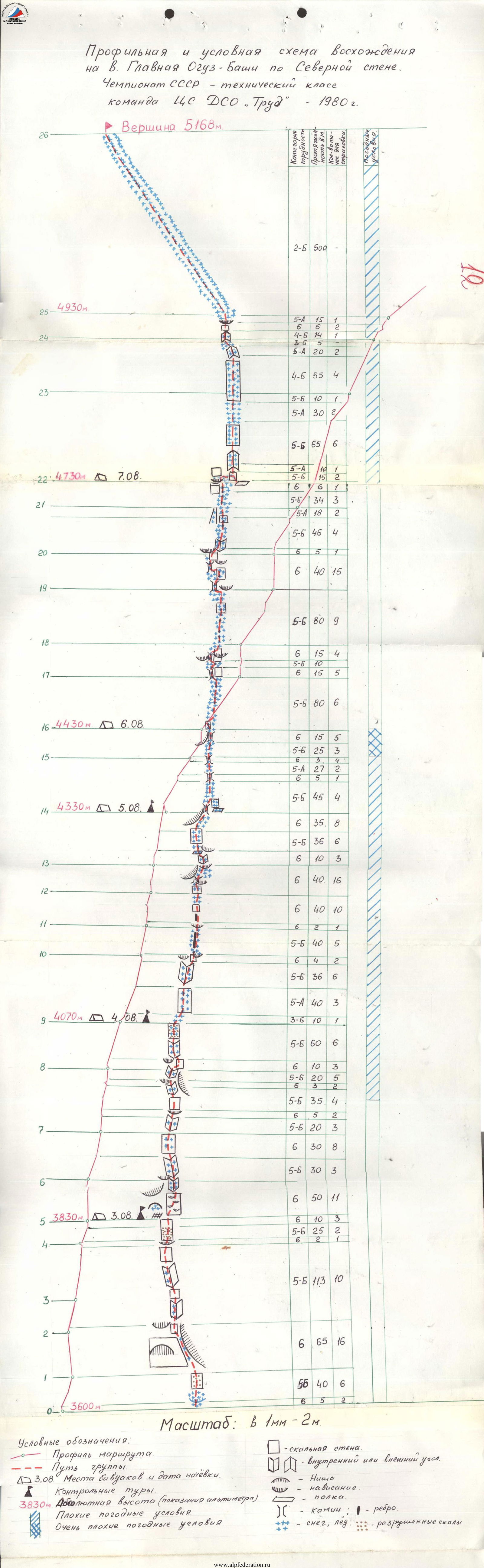
Table
of the main characteristics of the ascent route
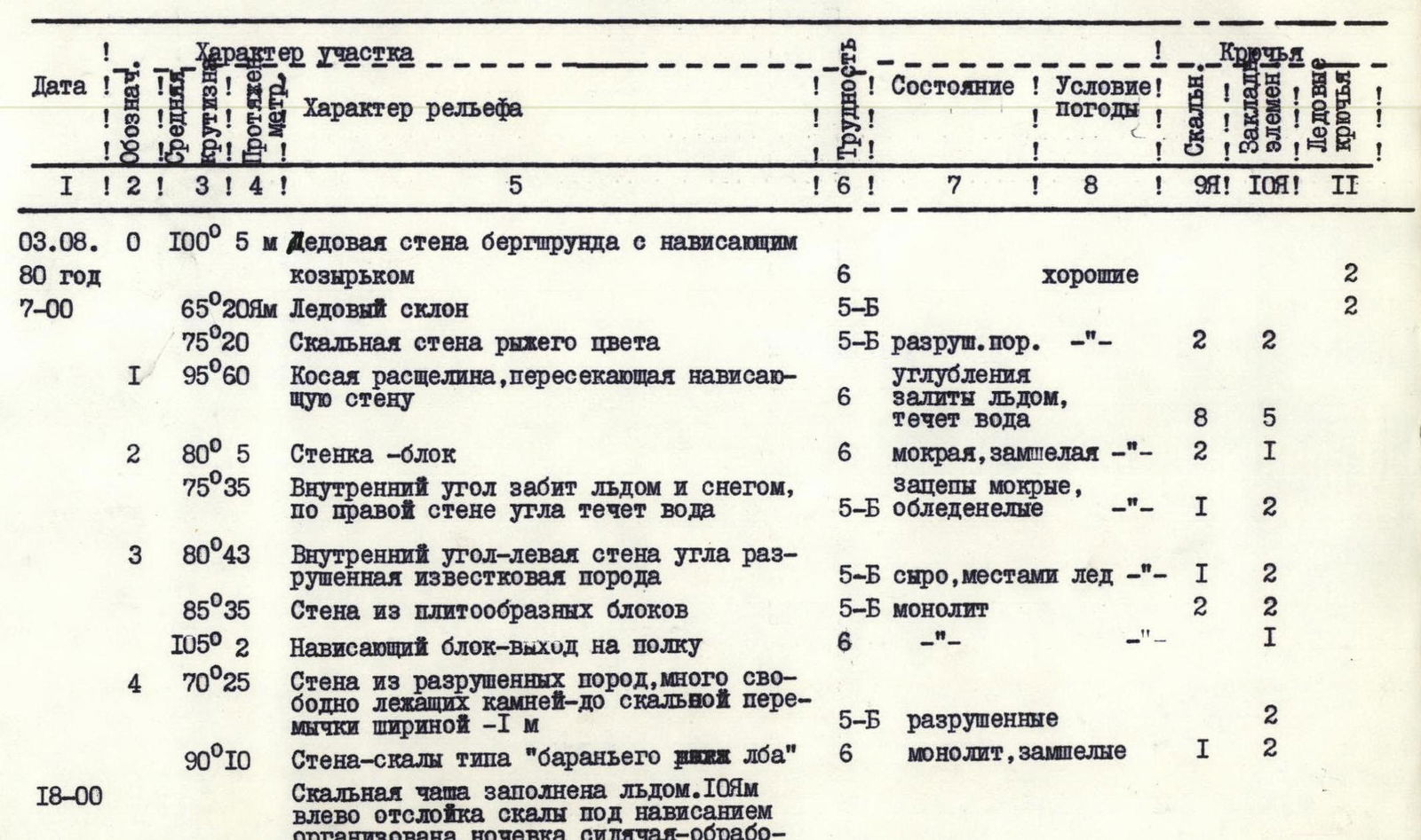

| Date | Marking | Steepness | Length, m | Terrain characteristics | Difficulty | Condition | Weather conditions | Rock pitons | закладные элементы | Ice pitons |
|---|---|---|---|---|---|---|---|---|---|---|
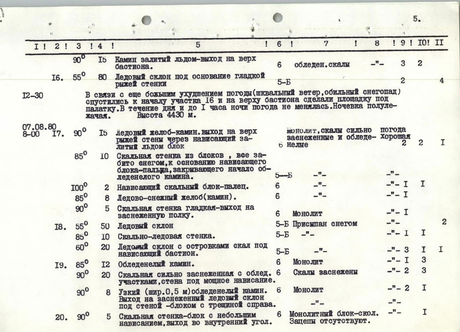
| 03.08.1980 г. | R0 | 100° | 5 | Ice wall of the bergschrund with an overhanging ledge | 6 | good | 2 | |||
| 65° | 20 | Ice slope | 5Б | 2 | ||||||
| 75° | 20 | Red-colored rock wall | 5Б | разруш. пор. | 2 | 2 | ||||
| R1 | 95° | 60 | Oblique crack crossing the overhanging wall | 6 | углубления | залиты льдом, течёт вода | 8 | 5 | ||
| R2 | 80° | 5 | Block-wall | 6 | мокрая, замшелая | 2 | 1 | |||
| 75° | 35 | Internal angle filled with ice and snow, water flows down the right wall of the angle | 5Б | зацепы мокрые, обледенелые | 1 | 2 | ||||
| R3 | 80° | 43 | Internal angle — the left wall is made of soft limestone | 5Б | сыро, местами лёд | 1 | 2 | |||
| 85° | 35 | Wall made of slab-like blocks | 5Б | монолит | 2 | 2 | ||||
| 105° | 2 | Overhanging block — exit to a ledge | 6 | 1 | ||||||
| R4 | 70° | 25 | Wall made of destroyed rocks, many loose stones — up to a rock bridge about 1 m wide | 5Б | разрушенные | 2 | ||||
| 90° | 10 | Wall-rock type "ram's forehead" | 6 | монолит, замшелые | 1 | 2 | ||||
| 18:00 | Rock "bowl" filled with ice. 10 m to the left, a rock slab under the overhang is used for a bivouac — processed 50 m ahead. 1st control tour. Height 3830 m. | |||||||||
| 04.08.1980 г. | R5 | 90° | 35 | Wall with overhanging tile-like slabs, icicles hanging down | 6 | участки натеч. льда | хорошие | 3 | 5 | |
| R6 | 80° | 15 | Internal angle with smooth walls, overhanging blocks on the left | 6 | натечный лёд | 2 | 1 | |||
| 70° | 30 | Internal angle, holds facing down | 5Б | лёд в углублениях | 2 | 1 | ||||
| 80° | 30 | Wall made of overhanging blocks with sections of ice nat | 6 | монолит | deterioration of weather | 3 | 5 | |||
| R7 | 85° | 20 | Internal angle: walls are destroyed — ice, snow. Exit from the angle is overhanging | 5Б | разрушен. заснеж. скалы | 1 | 2 | |||
| 95° | 5 | Overhanging wall | 6 | монолитный блок | 2 | |||||
| 85° | 20 | Wall with snow-covered micro-holds | 5Б | монолит, скалы сух. | 3 | |||||
| 75° | 15 | Ledge-angle above the overhanging wall, width up to 0.3 m — undercutting filled with snow, ice | 5Б | участок обледенелых скал | thunderstorm began | 1 | ||||
| 95° | 3 | Overhanging block with a crack | 6 | монолит, замшелый, мокрый | precipitation in the form of sleet and snow | 2 | ||||
| 85° | 20 | Internal angle — walls are smooth, wet, inside the angle is ice up to a ledge under a powerful overhang | 5Б | 2 | 3 | |||||
| R8 | 90° | 10 | Wall — to the right of the overhang | 6 | монолит | 1 | 2 | |||
| 75° | 30 | Internal angle, water and ice on the walls | 5Б | разр. скалы | 1 | 2 | ||||
| 75° | 30 | Wall made with large-block destroyed rocks | 5Б | 2 | 1 | |||||
| 18:00 | Ice bridge under the beginning of the upper part of the lower wall. A platform for a tent is cut out and laid — semi-recumbent overnight stay — processed 80 m ahead. 2nd control tour. Height 4070 m. | |||||||||
| 05.08.1980 г. | R9 | 40° | 10 | Ice bridge | 3Б | Лёд присыпан снегом | неудовл. | 1 | ||
| 70° | 40 | Wall made of large blocks. | 5А | Скалы в мокром снегу | туман, временами мокр. снег | 1 | 2 | |||
| 80° | 36 | Internal angle with an overhanging section (block) at the top. | 5Б | Скалы скольз. | 2 | 4 | ||||
| R10 | 95° | 4 | Overhanging wall-block — exit to a ledge under the overhanging wall (15 m to the left is a good platform for an overnight stay) | 6 | Монолит, зацепы в мокром снегу | 1 | 1 | |||
| 80° | 40 | Not clearly expressed counterfort made of large blocks (bypass of the overhanging wall — to the right) | 5Б | Скалы в мокром снегу. | 2 | 3 | ||||
| R11 | 95° | 2 | Wall with a slight overhang. | 6 | Монолит | 1 | ||||
| 85° | 15 | Not clearly expressed counterfort with smoothed holds. | 6 | Монолит, скалы мокрые. | 3 | |||||
| 90° | 8 | Wall with an overhanging upper part. | 6 | Монолит, участки натечного льда | 3 | 1 | ||||
| R12 | 95° | 2 | Overhanging part of the wall, exit to the ice forehead. | 6 | 1 | |||||
| 70° | 15 | Ice ridge. | 6 | Лёд присыпан снегом. | 2 | |||||
| 90° | 10 | Smooth rock wall. Overhanging, tile-like rocks under the chimney filled with ice. | 6 | Монолит, зацепы сглажены в снегу. | 3 | 2 | ||||
| 85° | 10 | Chimney filled with ice. | 6 | Монолит, wall of the chimney is smoothed. | 2 | 1 | ||||
| 80° | 12 | Narrow, ice-filled terrace under the overhanging wall on the left. | 6 | 1 | 3 | |||||
| 90° | 5 | Smooth wall without holds. Several blind notches. | 6 | Монолит | 2 | |||||
| R13 | 95° | 3 | Overhanging wall. A foothold under the overhang. | 6 | Монолит | 2 | ||||
| 85° | 10 | Internal angle filled with ice | 5Б | 3 | ||||||
| 85° | 3 | Wall type "ram's forehead". | 2 | |||||||
| 60° | 8 | Ice slope-couloir | 5Б | Лёд покрыт слоем мокр. снега | 1 | |||||
| 80° | 25 | Large-block rock wall | 5Б | Щели и полки забиты мокрым снегом. | 3 | |||||
| 80° | 35 | Ice-rock slope under a large overhanging wall-tower. Exit to the top of the tower is on the right. To the right and down 10 m is a rocky cape. A bivouac can be organized. | 6 | Скалы залиты натечным льдом | 3 | 5 | ||||
| 18:00 | A bivouac is organized on the rocky cape — worked 80 m of the further route. 3rd control tour. Height 4330 m. | |||||||||
| 06.08.1980 г. | R14 | 85° | 10 | Ice-rock wall, exit to the "edge". | 5Б | Скалы в снегу с участками льда | Weather is unsatisfactory, wet snow, wind | 2 | ||
| 60° | 35 | Ice slope covered with snow | 5Б | 2 | ||||||
| 85° | 5 | Ice gutter (chimney) between rock towers. | 6 | Скалы залиты льдом. | 1 | |||||
| 55° | 27 | Ice edge covered with snow | 5А | 2 | ||||||
| 90° | 3 | Chimney filled with ice | 6 | Скалы залиты льдом | 3 | 1 | ||||
| R15 | 55° | 25 | Ice slope under an overhanging bastion | 5Б | 3 | |||||
| R16 | 90° | 15 | Chimney filled with ice — exit to the top of the bastion. | 6 | обледен. скалы | 3 | 2 | |||
| 55° | 80 | Ice slope to the base of a smooth, rusty wall | 5Б | 2 | 4 | |||||
| 12:30 | Due to further deterioration of the weather (gusty wind, heavy snowfall), we descended to the beginning of section R16 and made a platform for a tent on top of the bastion. The weather did not change throughout the day and until 1 am. Height 4430 m. | |||||||||
| 07.08.1980 г. | R17 | 90° | 15 | Ice gutter-chimney. Exit to the top of the rusty wall through an overhanging block filled with ice | 6 | монолит, скалы сильно заснеженные и обледенелые | weather is good | 2 | 2 | 1 |
| 85° | 10 | Rock wall made of blocks, all filled with snow, to the base of the overhanging block-finger closing the beginning of the ice-filled chimney | 5Б | 1 | ||||||
| 100° | 2 | Overhanging rock block-finger. | 6 | 1 | ||||||
| 85° | 8 | Ice-snow gutter (chimney). | 6 | 1 | ||||||
| R18 | 90° | 5 | Rock wall is smooth — exit to a snow-covered ledge. | 6 | Монолит | 1 | ||||
| 55° | 50 | Ice slope | 5Б | Присыпан снегом | 2 | |||||
| 85° | 10 | Rock-ice wall. | 5Б | 1 | 1 | |||||
| R19 | 60° | 20 | Ice slope with rock outcrops under an overhanging bastion. | 5Б | 3 | 1 | 1 | |||
| 85° | 12 | Ice-filled chimney. | 6 | Монолит | 1 | 3 | ||||
| 90° | 20 | Rock wall is heavily snow-covered with ice sections, under a powerful overhang. | 6 | Скалы заснежены | 2 | 3 | ||||
| R20 | 90° | 8 | Narrow (width 0.5 m) ice-filled chimney. Exit to a snow-covered ice slope under a wall-block with a crack on the right. | 6 | Монолит | 2 | 1 | |||
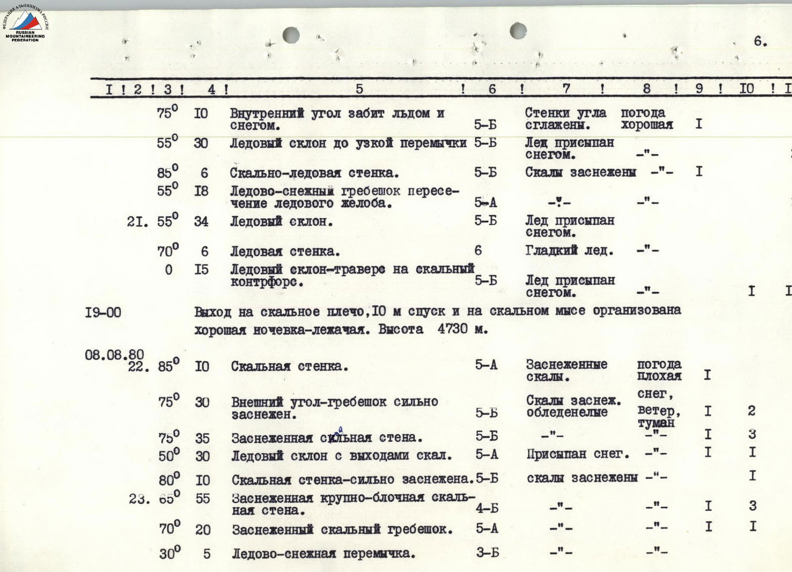
| R21 | 75° | 10 | Internal angle filled with ice and snow. | 5Б | Walls of the angle are smoothed. | good | 1 | |||
| 55° | 30 | Ice slope to a narrow bridge | 5Б | Лед присыпан снегом. | 2 | |||||
| 85° | 6 | Rock-ice wall. | 5Б | Скалы заснежены | 1 | |||||
| 55° | 18 | Ice-snow ridge, crossing an ice gutter. | 5А | 2 | ||||||
| 55° | 34 | Ice slope. | 5Б | Лед присыпан снегом. | 3 | |||||
| 70° | 6 | Ice wall. | 6 | Гладкий лед. | 1 | |||||
| 0° | 15 | Ice slope — traverse to a rock counterfort. | 5Б | Лед присыпан снегом. | 1 | 1 | ||||
| 19:00 | Exit to a rock shoulder, 10 m descent, and a good bivouac is organized on a rocky cape. Height 4730 m. | |||||||||
| 08.08.1980 г. | R22 | 85° | 10 | Rock wall. | 5А | Заснеженные скалы. | weather is bad | 1 | ||
| 75° | 30 | External angle-ridge is heavily snow-covered. | 5Б | Скалы заснеж. обледенелые | snow, wind, fog | 1 | 2 | |||
| 75° | 35 | Snow-covered strong wall. | 5Б | 1 | 3 | |||||
| 50° | 30 | Ice slope with rock outcrops. | 5А | Присыпан снег. | 1 | 1 | ||||
| R23 | 80° | 10 | Rock wall — heavily snow-covered. | 5Б | скалы заснежены | 1 | ||||
| 65° | 55 | Snow-covered large-block rock wall. | 4Б | 1 | 3 | |||||
| 70° | 20 | Snow-covered rock ridge. | 5А | 1 | 1 | |||||
| 30° | 5 | Ice-snow bridge. | 3Б | |||||||
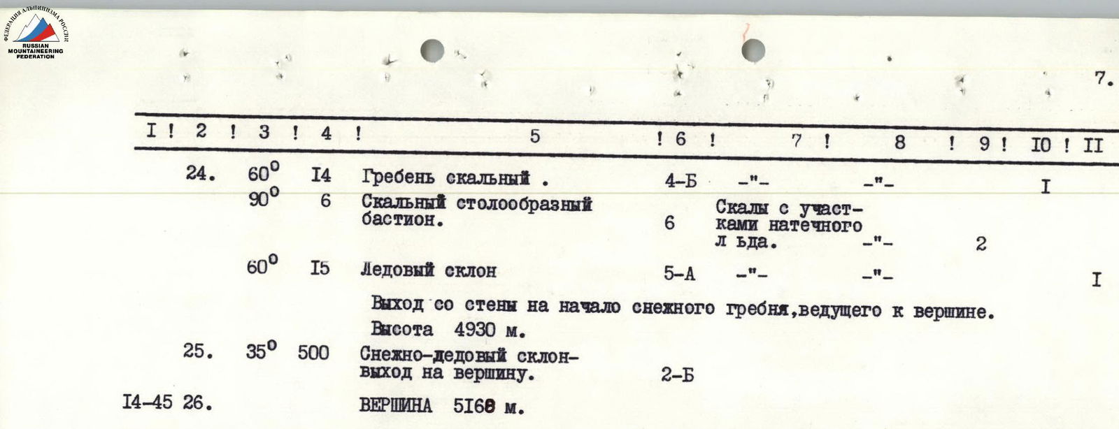
| R24 | 60° | 14 | Rocky ridge. | 4Б | 1 | |||||
| 90° | 6 | Rock table-like bastion. | 6 | Скалы с участками натечного льда. | 2 | |||||
| R25 | 60° | 15 | Ice slope | 5А | 1 | |||||
| R26 | 35° | 500 | Snow-ice slope — exit to the summit. | 2Б | ||||||
| 14:45 | ВЕРШИНА | 5168 м. |

Explanatory note (to the table)
August 3. The group consisting of Sharov O.Ya., Dusharin I.T., Kazzaev Yu.V., and Blokhin V.A. left the overnight stay on the moraine of the glacier at 5:00. The task for the first day was to pass the icefall and part of the wall. Passing the icefall took about two hours. Due to heavy fog, they climbed in pairs and spent a bit more time than planned.
R0–R1. The exit to the wall begins with overcoming the bergschrund with an overhanging snow-ice ledge (5 m) and then continues along a steep ice slope to the destroyed rocks (20 m). Overcoming the bergschrund:
- Is performed on stirrups using ice axes;
- Insurance is organized through "ice screws";
- Backpacks are pulled up to one of the shelves of the destroyed rock wall. The section is stonefall-prone.
R1–R2. Ahead is an overhanging wall; the path is only through a deep, oblique crack, many sections of which are covered with a layer of ice and have water flowing down. Climbing is extremely difficult; rock sections overhang, requiring the use of:
- Loops;
- Ladders;
- закладные элементы. Backpacks are pulled up.
R2–R3. The crack turns into an internal angle (35 m); the exit is through a mossy, wet wall (5 m). The internal angle is filled with ice and snow; water flows down the walls; the rocks are slippery, and the right side of the angle is smoothed.
R3–R4. Through a wall on the left, there is a transition to another internal angle, which is very damp; the left side of the angle is made of soft limestone (43 m). The angle abuts a wall with a slab-like structure. Climbing is difficult but enjoyable; the slabs are practically dry. The exit is through an overhanging block (2 m) to a stony ledge. A loop is used for the exit.
R4–R5. Further, the route is a destroyed wall (25 m) with many loose stones; to the left and right, 100–120 m away, stones and ice fragments are continuously falling. The wall leads to a small rock bridge. Then, there is a sheer wall of rock type "ram's forehead" (10 m) with very small holds.
R5–R6. They entered a rock "bowl" (a depression filled with ice). Ahead is a wall with powerful overhanging sections. They proceed to the right where the overhanging