Ascent Passport
- Ascent class — technical.
- Ascent area — Central Tian-Shan, Terskey-Alatau ridge.
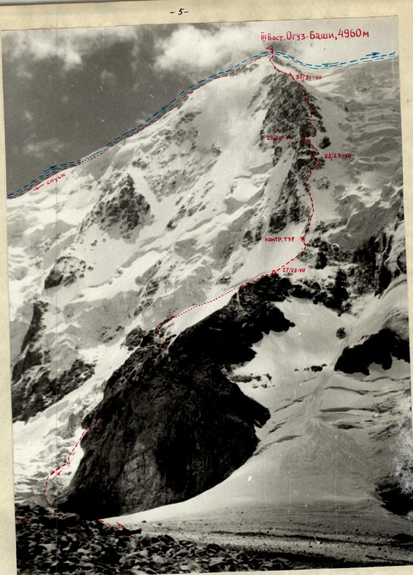
- Peak — III-y Vostochnaya Oguz-Bashi, its height is 4960 m, ascent route — via the northern edge.
- Proposed difficulty category — 5B
- Route characteristics: height difference — 1560 m, length of sections 5–6 — 759 m, average steepness — 70°.
- Pitons hammered: for belay: rock — 82, ice — 64, bolt — 0, of which for creating artificial holds — 3
- Number of walking hours — 48
- Number of bivouacs and their characteristics: 1st bivouac lying down, very good; 2nd bivouac — semi-reclining; 3rd and 4th bivouacs lying down.
- Surname, name, patronymic of the leader, participants and their qualification: Boshman Verner Frantsevich — leader, CMS, instructor; Kapanin Vladimir Aleksandrovich — participant, CMS, instructor; Slepushkin Evgeny Filippovich — participant, MS, instructor; Streltsov Evgeny Aleksandrovich — participant, CMS.
- Team coach — Denisov V.G., MS, instructor.
- Date of departure on the route — July 27, 1977, return — August 2, 1977
To the ascent passport
- Route of the Sports Committee team of the Kirg. SSR (July 27–31, 1977, leader Boshman V.)
- Route of the team from Chelyabinsk Regional Council of the "Trud" Sports Society (Aug. 1962, leader Rozanov V.)
- Route of the Sports Committee team of the Kirg. SSR (Aug. 1962, leader Tustukbaev A.)
Map of the axial part of the Terskey-Alatau ridge in the upper reaches of the Djety-Oguz river.

| 1 | 2 | 3 | 4 | 5 | 6 | 7 | 8 | 9 | 10 | 11 | 12 | 13 | 14 | 15 |
|---|---|---|---|---|---|---|---|---|---|---|---|---|---|---|
| Date | Des. | Avg. steepness, deg. | Length, m | Terrain characteristics | Difficulty | State | Weather conditions | Rock | Ice | Bolt | Rock | Ice | Bolt | |
| 1977 July 27 | ||||||||||||||
| 50 | 80 | Icefall | 4 | Snow-covered | Very good, warm, clear | 2 | ||||||||
| 50 (up to 60) | 240 | Icefall | 4 | Snow-covered | 5 | |||||||||
| 40 | Ice-rock avalanche deposit | |||||||||||||
| 40 | Icefall | 4 | 1 | |||||||||||
| 1 | 50 | 40 | Firn slope | 1 | ||||||||||
| 45 | 30 | Inclined rock shelf | U | Rocks destroyed, wet, partially snow-covered | Weather very good, warm | Handholds | 4 | |||||||
| 70–75 | 30 | Internal corner | U | |||||||||||
| 75 | 20 | Wall | U | 2 | ||||||||||
| 10 | 3 | Rock shelf | 4 | Highly rockfall-prone | ||||||||||
| 70 | 40 | Weakly expressed edge | 5 | |||||||||||
| 15 | 20 | Oblique rock shelf | 4 | Handholds | 3 | |||||||||
| 65 | 20 | Rock chute (internal corner) | U | |||||||||||
| 80 | 5 | Rock wall | U | 2 | ||||||||||
| 55 | 120 | Inclined rock shelf | 4 | |||||||||||
| 50 | 30 | Ice slope | 4 | Snow-covered, wet | 1 | |||||||||
| July 28, 1977 | 2 | 45 | 150 | Rock destroyed ridge | 2 | Partially snow-covered | ||||||||
| 40 | 80 | Destroyed rocks | 2 | |||||||||||
| 3 | 40 | 80 | Sharp snow-ice ridge | Snow-covered | Overcast, rare snowflakes, calm | 5–10 cm | ||||||||
| 4 | 45 | 120 | Highly destroyed rocks, alternating with ice sections. Control cairn | 3–4 | Iced, snow-covered | 1 | ||||||||
| 45 | 40 | Highly destroyed rocks | 3–4 | |||||||||||
| 65 | 15 | Rock wall | 4 | Iced | 2 |
| 1 | 2 | 3 | 4 | 5 | 6 | 7 | 8 | 9 | 10 | 11 | 12 | 13 | 14 | 15 |
|---|---|---|---|---|---|---|---|---|---|---|---|---|---|---|
| 5 | 60–70 | 200 | Ice slope, weakly expressed ridge | 4–5 | Snow-covered, up to 5–7 cm | 13 | ||||||||
| 6 | 65 | 60 | Rock ridge | U | Partially iced, rocks loose | 5 | ||||||||
| 7 | 65 | 60 | Edge of ice and rocks like "ram's foreheads" or slabs | U | Ice snow-covered, rocks iced | Clear, warm | 4 | 1 | ||||||
| 8 | 70 | 15 | Ice slope 70° under rock wall (I pinnacle) | U | Ice snow-covered | 2 | ||||||||
| 9 | 75–80 | 10 | Rock wall | U | Snow-covered with ice crust | Bad weather, wind, fog, snow | 2 | |||||||
| 75–80 | 20 | Ice chute in rocks | L | Snow-covered | 3 | 3 | ||||||||
| 45 | 7 | Rock slab | U | Snow-covered | 2 | |||||||||
| 10 | 50 | 25 | Snow-ice couloir with rock outcrops in middle part | 4 | Wet snow on ice | 2 | 3 | |||||||
| July 29, 1977 | 70 | 10 | Crossing ice couloir | U | Snow-covered | Clear, wind | 1 | |||||||
| 11 | 45 | 5 | Ice ridge | U | ||||||||||
| 70 | 20 | Ice slope under rock wall, traverse | U | Clear, warm | 3 | 1 | ||||||||
| 60 | 10 | Ice couloir with embedded rocks | U | Wet snow cover | Calm | 2 | ||||||||
| 12 | 75 | 15 | Rock wall, iced | U | Wet, iced | 2 | ||||||||
| 65 | 30 | Ice slope with rock outcrops | U | Wet snow cover | 2 | |||||||||
| 13 | 65 | 30 | Rocks highly destroyed, steep | U | Destroyed, iced, snow-covered | Snowfall, strong wind, blizzard | 2 | |||||||
| Exit to ridge, tent. | ||||||||||||||
| 14 | 45 | 40 | Rock-ice ridge | 4 | Snow-covered | Wind, cold |

| 1 | 2 | 3 | 4 | 5 | 6 | 7 | 8 | 9 | 10 | 11 | 12 | 13 | 14 | 15 |
|---|---|---|---|---|---|---|---|---|---|---|---|---|---|---|
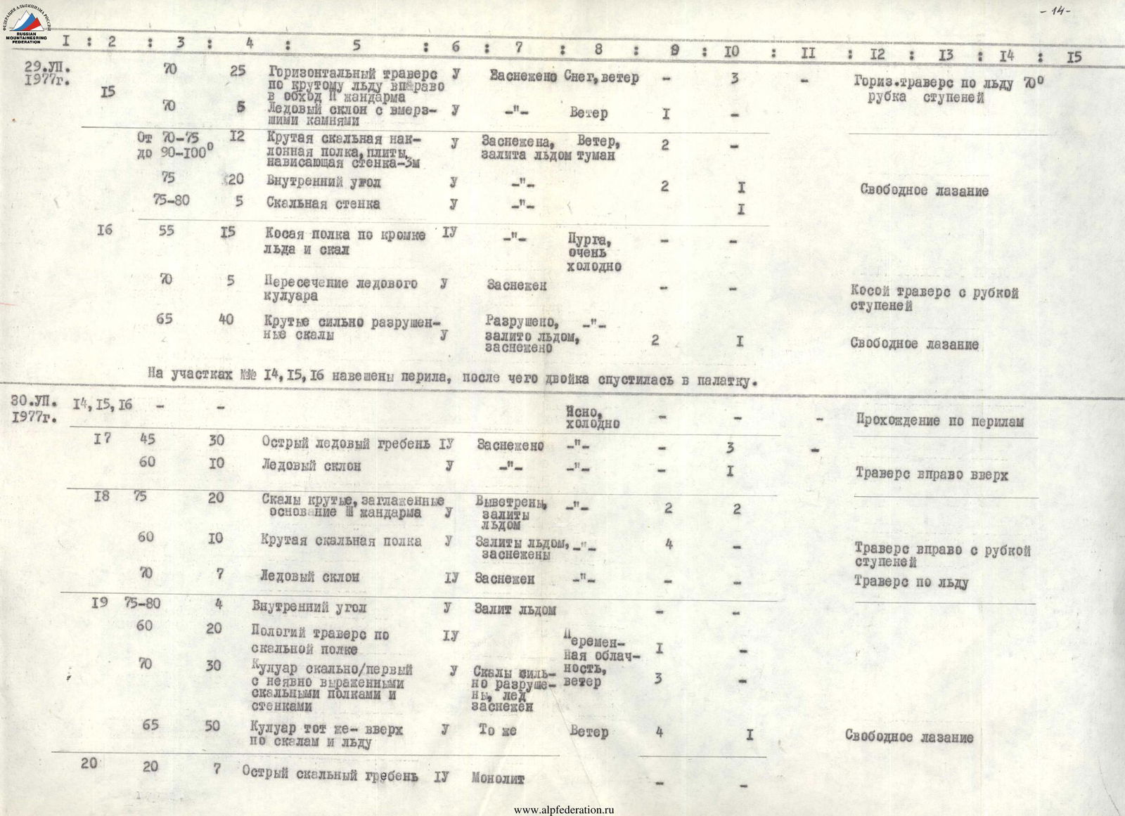
| July 29, 1977 | 15 | 70 | 25 | Horizontal traverse on steep ice to the right, bypassing II pinnacle | U | Snow-covered | Snow, wind | 3 | ||||||
| 70 | 5 | Ice slope with embedded rocks | U | Wind | 1 | |||||||||
| 70–75 up to 90–100 | 12 | Steep inclined rock shelf, slabs, overhanging wall – 5 m | U | Snow-covered, iced | Wind, fog | 2 | ||||||||
| 75 | 20 | Internal corner | U | 2 | 1 | |||||||||
| 75–80 | 5 | Rock wall | U | 1 | ||||||||||
| 16 | 55 | 15 | Oblique shelf along edge of ice and rocks | 4 | Blizzard, very cold | |||||||||
| 70 | 5 | Crossing ice couloir | U | Snow-covered | ||||||||||
| 65 | 40 | Steep highly destroyed rocks | U | Destroyed, iced, snow-covered | 2 | 1 | ||||||||
| At sections # R14, R15, R16, fixed ropes are installed, after which the pair descended to the tent. | ||||||||||||||
| July 30, 1977 | Clear, cold | |||||||||||||
| 17 | 45 | 30 | Sharp ice ridge | 4 | Snow-covered | 3 | ||||||||
| 60 | 10 | Ice slope | U | 1 | ||||||||||
| 18 | 75 | 20 | Steep rocks, smoothed, base of pinnacle | U | Weathered, iced | 2 | 2 | |||||||
| 60 | 10 | Steep rock shelf | U | Iced, snow-covered | 4 | |||||||||
| 70 | 7 | Ice slope | 4 | Snow-covered | ||||||||||
| 19 | 75–80 | 4 | Internal corner | U | Iced | |||||||||
| 60 | 20 | Gentle traverse on rock shelf | 4 | Variable cloudiness | 1 | |||||||||
| 70 | 30 | Couloir of rocks/first with weakly expressed rock shelves and walls | U | Rocks strong, but destroyed, ice snow-covered | Wind | 3 | ||||||||
| 65 | 50 | Same couloir – upwards on rocks and ice | U | Same | Wind | 4 | 1 | |||||||
| 20 | 20 | 7 | Sharp rock ridge | 4 | Monolithic |
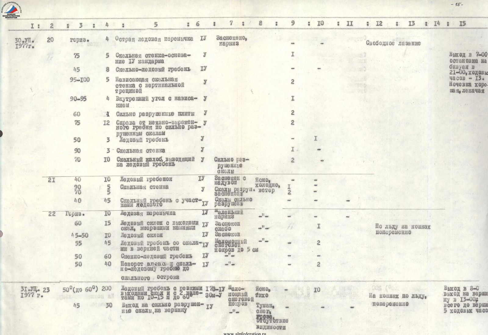
| 1 | 2 | 3 | 4 | 5 | 6 | 7 | 8 | 9 | 10 | 11 | 12 | 13 | 14 | 15 |
|---|---|---|---|---|---|---|---|---|---|---|---|---|---|---|
| July 30, 1977 | 20 | horiz. | 4 | Sharp ice ridge | 4 | Snow-covered, cornice | ||||||||
| 75 | 5 | Rock wall – base of IV pinnacle | U | 1 | ||||||||||
| 45 | 8 | Rock-ice ridge | 4 | |||||||||||
| 95–100 | 5 | Overhanging rock wall with vertical crack | U | 2 | ||||||||||
| 90–95 | 4 | Internal corner with overhang | U | 1 | ||||||||||
| 60 | 4 | Highly destroyed slabs | U | 2 | ||||||||||
| 75 | 12 | To the right of weakly expressed ridge on highly destroyed rocks | U | 2 | ||||||||||
| 50 | 3 | Ice ridge | U | 1 | ||||||||||
| 90 | 3 | Rock wall | U | 1 | ||||||||||
| 70 | 10 | Rock chute leading to ice ridge | U | Highly destroyed rocks | 2 | |||||||||
| 21 | 40 | 10 | Ice ridge | 4 | Snow-covered with drift | Clear, cold, wind | 1 | |||||||
| 90 | 5 | Rock wall | U | Rocks destroyed, snow-covered | 2 | |||||||||
| 70 | 5 | Rock ridge with ice sections | 4 | |||||||||||
| 40 | 45 | Rock ridge with ice sections | 4 | Rocks highly destroyed | ||||||||||
| 22 | Horiz. | 10 | Ice ridge | 4 | Small cornice | |||||||||
| 60 | 15 | Ice slope with rock outcrops, embedded rocks | 4 | Weakly snow-covered | 1 | |||||||||
| 45–50 | 10 | Ice slope | 4 | Snow-covered | ||||||||||
| 55 | 45 | Ice ridge with rocks in upper part | 4 | Thin snow cover up to 5 cm | 2 | |||||||||
| 50 | 60 | Snow-ice ridge | 4 | |||||||||||
| 50 | 40 | Turn left towards rock-ice ridge to rock island | 4 | Variable cloudiness | 1 | |||||||||
| July 31, 1977 | 50–60 | 200 | Ice ridge with sharp rock outcrops and ledges up to 60° | 4–5 | Thin snow cover | Clear, calm | 10 | |||||||
| 45 | 30 | Exit to highly destroyed rocks, to summit | U | Fog, snow, thunderstorm, no visibility |
Brief explanation for the table (description of movement by days)
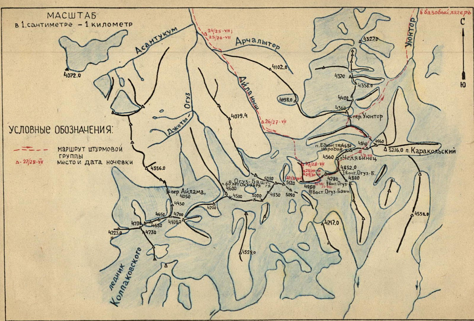
July 24, 1977 — departure from Karakol valley (base camp at the confluence of Uyuktor and Köl-Tor) — via Przewalski, settlement Dzhety-Oguz, Dzhety-Oguz resort upstream along the Dzhety-Oguz river to the mouth of the Telety river (right tributary of Dzhety-Oguz) — end of the road. From the mouth of Telety river — approach with very heavy backpacks to the fork in the valley of the Ay-Lanysh and Dzhety-Oguz rivers (3 hours). Stop for bivouac (see map).
July 25, 1977. Divided into 2 groups of 4 people, we conducted reconnaissance of the cirques in the upper reaches of the Dzhety-Oguz and Ay-Lanysh rivers to choose uncharted routes of approximately 5th category of difficulty. In each cirque, 6–8 such routes were found.
July 26, 1977. From the fork of the Dzhety-Oguz and Ay-Lanysh rivers upstream along the right (orographic) side of the Ay-Lanysh river for 3 hours along the trail, we approach the site of the assault camp. We spent the remaining half of the day preparing for the ascent on the route via the northern edge of the III eastern peak of Oguz-Bashi (4960 m), observing the route, instructing a group of observers (3 people led by N. Matyushin), and agreeing on interaction with the group of F.E. Popov, departing on the same day to peak 4680 m in the eastern part of the Ay-Lanysh cirque.
July 27, 1977 at 6:00, we depart from the assault camp upstream along the moraine, cross the glacier, and by 8:00 approach the base of the rocky northern edge of the III eastern peak of Oguz-Bashi. To the right and left of the rocky island at the base of the edge, movement is extremely dangerous due to frequent ice avalanches from the hanging glaciers, so we choose a path via the icefall, bypassing the island on the left, and then exit to the rocks, steep, smoothed, and highly destroyed, where there is no danger of ice avalanches. Along these rocks and ice in their upper part, we exit to the top of the island, where at 17:00 we stop for bivouac, as there are no convenient places for an overnight stay on the ice ridge and slope above. The weather is good all day.
July 28, 1977. In the morning, it's overcast. We depart at 7:00 — first along a sharp snow-ice ridge, interspersed with rock sections. On one of the rock sections, we install a control cairn. Above, the route passes along a weakly snow-covered ice slope with gradually increasing steepness (section R5), then along rocks iced and along the edge of rocks and ice under the sheer wall of the I pinnacle, along the edge of sheer rocks and steep 65–70° ice — on ice, we move to the right (15 m traverse on ice with step cutting). Further, we move upwards to the left of the ice chute along a rock wall and along the chute itself (ice up to 75–80°) with step cutting in the ice and using ice screws in the ice for belay and as artificial holds. The ice is serac (10–15 cm thick), ice screws, resting against the rock, do not fully rotate, but hold well. The weather deteriorates sharply — fog, wind, graupel. Above the chute, on the lateral ice ridge in the upper part of the oblique ice couloir (25 m), after cutting 1.5 m of ice, we install a tent (20:00). Bivouac is semi-reclining. Bad weather continues throughout the day, evening, and night.
July 29, 1977. In the morning, bad weather — snowfall, fog, no visibility, so we depart only at 10:00. Rocks are snow-covered, iced, as when illuminated by the sun, streams run from them. On this day, we pass only 2 ropes (60 m each) and exit to a snow-ice ridge. One pair remains to cut ice and snow from the ridge and set up a tent (at 17:00) due to a sharp deterioration in the weather (wind, snow, fog). Another pair departs to process the route above the tent (bypassing the II black-red pinnacle to the right). The pair on the ridge approaches under the pinnacle, then traverses almost horizontally along very steep ice with step cutting, bypassing it to the right, and further upwards along steep complex rocks and ice, exits to the ridge, to the top of the pinnacle. 160 m of fixed ropes are installed from the tent to the top of the pinnacle (2×60 m and 1×40 m). The weather deteriorates sharply, and by 20:30, the pair descends along the fixed ropes to the tent.
July 30, 1977. In the morning, from 7:00 to 9:00, we pass the installed fixed ropes — exit directly to the edge. Further, the route passes to the right along the descent from the edge, bypassing the III pinnacle along inclined iced slopes above the right slope (sections R17–R19). The weather is cold with variable cloudiness and strong wind on the ridge. Along the couloir to the left upwards, we exit again to the ridge and further along it, we encounter the IV pinnacle, which is passed head-on (sections R20–R21, see table) and has the appearance of a steep, sometimes overhanging, stepped wall. The upper part of the IV pinnacle again takes the form of a ridge, which somewhat decreases, forming a snow-ice saddle under the ice slope. The weather deteriorates — strong wind, fog. The ice slope (about 170 m) is passed on crampons with belay via ice screws, rock outcrops, and ice axe. Above the rocky island, after cutting about 1.5 m of ice in the upper part, a tent is installed at 21:00.
July 31, 1977. We depart at 8:00. We pass an ice ridge about 200 m long and by 13:00 exit to the summit along highly destroyed rocks. A note is left in the rocks (10 m below the highest point — a snow drift). The weather deteriorates sharply — fog, snowfall, wind, and, worse still, a thunderstorm. Hair stands on end, and ice axes hum. Thunder is heard very close, and in the area of the main peak of Oguz-Bashi, it rumbles continuously. We descend from the ridge by 20 m (below it's very steep) and wait out the bad weather for 1.5 hours. We decide to descend to the east, towards the Karakol peak, as there is a thunderstorm in the area of the main peaks of Oguz-Bashi, and it's impossible to find a path to them on the wide pre-summit plateau in the fog. Moreover, we recall the especially frequent cornices on this section in 1969. At 14:30, some visibility appears, and the ridge is sometimes visible in the gaps of the fog. The path is familiar, as two members of the group (E. Slepushkin and E. Streltsov) passed this ridge from east to west (in 1969). We move very cautiously, staying to the right along the steep northern slope to avoid getting on the cornices hanging south. Often, we have to stop, as there is no visibility, and we need to move very carefully. We descend along ice (60°) from a large cornice with icicles. Further, there's a very narrow ice-firn ridge with cornices of fresh snow hanging south. Several small (fresh) cornices, 4–5 m long, break off under the hands and feet of the participants. We cross the NW slope of a large snow-ice cornice and descend to the saddle. At 19:00, we stop for bivouac. The weather improves towards night — clear sky.
August 1, 1977. In the morning, the weather is good. Departure at 8:00. The ridge has generally the same character. We pass a huge snow drift, and the descent from it to the saddle is similar to the narrow ice-firn ridge with fresh cornices passed the day before, which easily break off. From the saddle — ascent to the II eastern peak of Oguz-Bashi (4780 m) along an ice slope with snow cover. On the summit, near a rocky massif, we retrieve a note from the Kyrgyz team dated August 17, 1969, led by A. Tustukbaev, who completed a traverse of peaks Dzhigit–Karakol–Oguz-Bashi–4909 m in 1969 (as mentioned earlier, two members of this team are part of our group). The descent from the II eastern peak of Oguz-Bashi is complex along a narrow ridge with bilateral X-shaped cornices. From the saddle — ascent to the I eastern peak of Oguz-Bashi — 4852 m, which is bypassed to the left along a wide and long bergschrund. Exit to the northern ice ridge of this peak and descent — 4×60 m ropes along an ice slope with ice screws left behind, and further to the saddle to p. Chelyabinec. On this descent, the weather deteriorates sharply, and there are two thunderstorm discharges. From the saddle, the descent to the southern side onto the glacier — flat, even, and wide — along it, there's a very gentle ascent, bypassing two peaks 4680 m and the saddle with p. 4840 m (western shoulder of the Karakol peak). Due to a sharp deterioration in visibility, movement is stopped, and at 19:00, the group stops for bivouac.
August 2, 1977. In the morning, the weather is good — departure at 9:15. We cross an ice slope in the NE direction above the "cushion" of the Karakol peak under ice falls along deep fresh snow and by 12:00 exit to the NW edge of the Karakol peak. From here — a familiar path to per. Uyuntor, which the group descends to at 17:00. By 22:30, the group descends to the base camp in the Karakol river valley.