PASSPORT
-
Ice and snow class
-
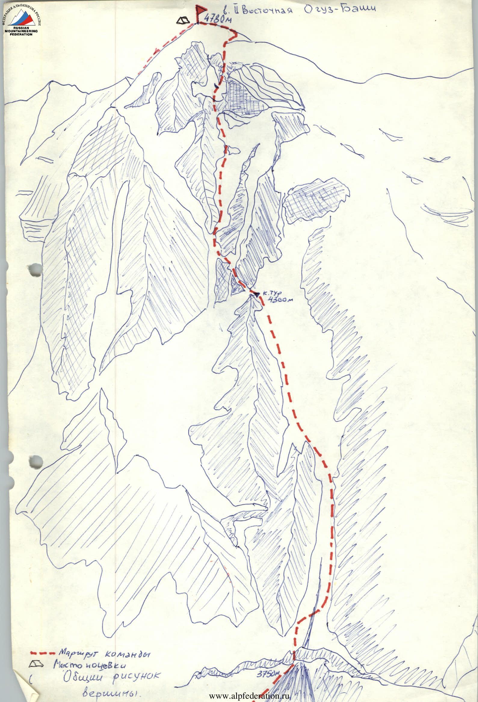
Tian-Shan, Jety-Oguz gorge
-
2nd Eastern Oguz-Bashi peak, center of the northern wall
-
Proposed 5B category of difficulty first ascent.
-
Height difference — 1000 m, length — 1500 m. Length of 5B category sections — 1200 m. Average steepness of the route (main part) 60° (3750–4600 m)
-
Pitons hammered in:
- Rock: 5/0
- Bolt: none
- Chocks: 15/0
- Ice: 380/0
-
Team's moving hours — 15, days — 1.
-
Overnight stay: 1 on the summit, on a snow site
-
Team leader: Tenenyev Valentin Alekseyevich — Candidate Master of Sports. Team members: Shevchenko Nikolay Alekseyevich — Master of Sports, Izmaylov Viktor Nikolayevich — Candidate Master of Sports, Sokolov Gleb Anatolyevich — Candidate Master of Sports
-
Coach: Shevchenko Nikolay Alekseyevich
-
Approach to the route: August 12, 1984.
- Summit: August 13, 21:00
- Return: August 14, 18:00
-
Organization: SKA-18

Tactical Actions of the Team
The team started moving on the route at 5:40, an hour later than planned according to the tactical plan, which was caused by poor visibility and rain from 23:00 to 01:00 at night. The bergschrund (R0–R1) was passed using "abs-fifi". The team's movement was non-stop. The lead climber went on a double rope (30 m), twisting pitons every 3–6 m, organizing self-arrest and belaying the second. The second climber, with top-rope belay and on the fixed rope, climbed to the lead, pulled the pitons and free rope towards themselves. The third climber ascended on the fixed rope with bottom belay and received the last one, who climbed on the fixed rope with top-rope belay, and untwisted the freed pitons.
Through R2–R3 ropes, the lead climber in the rope team changed; through R2–R6 ropes, the rope teams changed. Izmaylov—Sokolov formed the first rope team, Shevchenko—Tenenyev — the second. On steep ice sections (R9–R13, R21–R22), the lead climber used two "abs-fifi" or a combination of "ice axe — abs-fifi". Using a device for twisting ice screws reduced the time of twisting an ice screw to an average of 20 seconds. Dark, rainy weather caused increased rockfall and avalanches. The safety of the route was ensured by passing hazardous areas under the cover of rocks. When approaching the R8–R9 section, it was established that the ice couloir planned for passage was extremely rockfall-prone. Therefore, the route was chosen along a narrow, ice-filled chimney, protected from rocks and ice. At the end of the R7–R8 section, a control cairn was built on the rocks. After reaching the ridge, the movement was simultaneous. The ascent to the summit was according to the tactical plan at 21:00, with an overnight stay on the summit in a snow hollow. The descent along the ridge via R19 Eastern Oguz-Bashi did not present difficulties, and was safe. It was started at 10:00 and completed at 18:00. Communication with observers was carried out on precise schedules from 8:00 to 22:00 using a P-147 radio station.
| Rock pitons | Chocks | Ice pitons | Route scheme in symbols | Section | Difficulty | Length | Steepness |
|---|---|---|---|---|---|---|---|
| 2 | (chart) | R0–R1 | 5 | 5 м | 85° | ||
| 23 | (chart) | R1–R2 | 5 | 85 м | 45° | ||
| 8 | (chart) | R2–R3 | 5 | 30 м | 45° | ||
| 54 | (chart) | R3–R4 | 5 | 180 м | 55° | ||
| 18 | (chart) | R4–R5 | 5 | 60 м | 55° | ||
| 45 | (chart) | R5–R6 | 5 | 150 м | 60° | ||
| 54 | (chart) | R6–R7 | 5 | 180 м | 65° | ||
| 2 | 25 | (chart) | R7–R8 | 5 | 90 м | 60° | |
| 18 | (chart) | R8–R9 | 5 | 60 м | 55° | ||
| 3 | (chart) | R9–R10 | 5 | 15 м | 85° | ||
| 6 | (chart) | R10–R11 | 5 | 15 м | 45° | ||
| 9 | (chart) | R11–R12 | 5 | 30 м | 65° | ||
| 2 | (chart) | R12–R13 | 5 | 10 м | 65° | ||
| 3 | 4 | (chart) | R13–R14 | 5 | 15 м | 75° | |
| 9 | (chart) | R14–R15 | 5 | 30 м | 65° | ||
| 27 | (chart) | R15–R16 | 5 | 90 м | 65° | ||
| 54 | (chart) | R16–R17 | 5 | 180 м | 60° | ||
| 1 | 2 | (chart) | R17–R18 | 5 | 10 м | 70° | |
| 3 | 2 | (chart) | R18–R19 | 4 | 20 м | 60° | |
| 1 | 4 | (chart) | R19–R20 | 4 | 30 м | 55° | |
| 9 | (chart) | R20–R21 | 5 | 30 м | 65° | ||
| 2 | (chart) | R21–R22 | 5 | 10 м | 85° | ||
| 7 | (chart) | R22–R23 | 5 | 20 м | 70° | ||
| 9 | (chart) | R23–R24 | 5 | 30 м | 55° | ||
| 2 | (chart) | R24–R25 | 2 | 30 м | 40° | ||
| 2 | (chart) | R25–R26 | 2 | 30 м | 45° | ||
| 2 | (chart) | R26–R27 | 2 | 100 м | 40° |
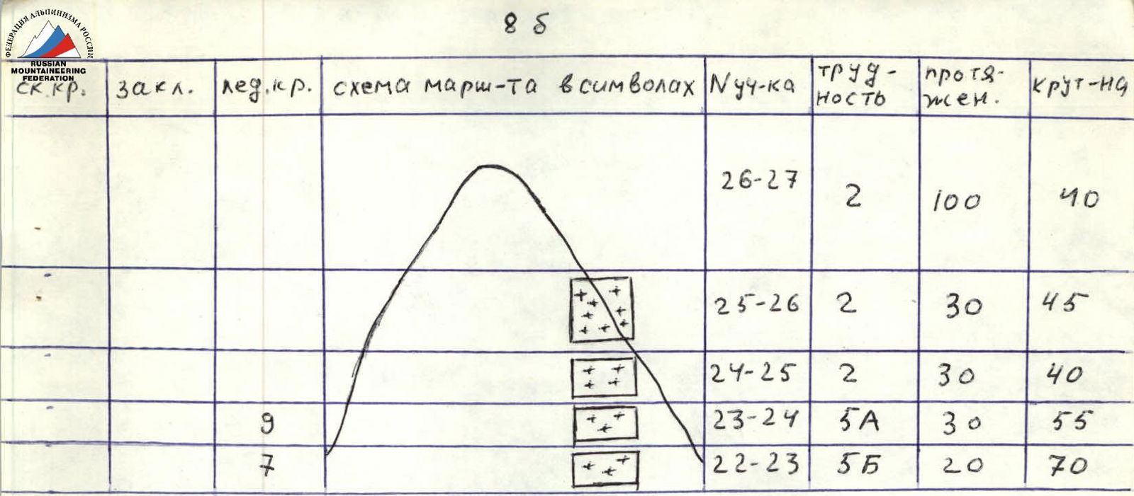
Total:
- rock pitons – 5
- chocks – 16
- ice pitons – 361
- Number of moving hours – 15.
On all sections R0–R24, there was hourly alternating belay with the organization of fixed ropes.
Description of the Route by Sections
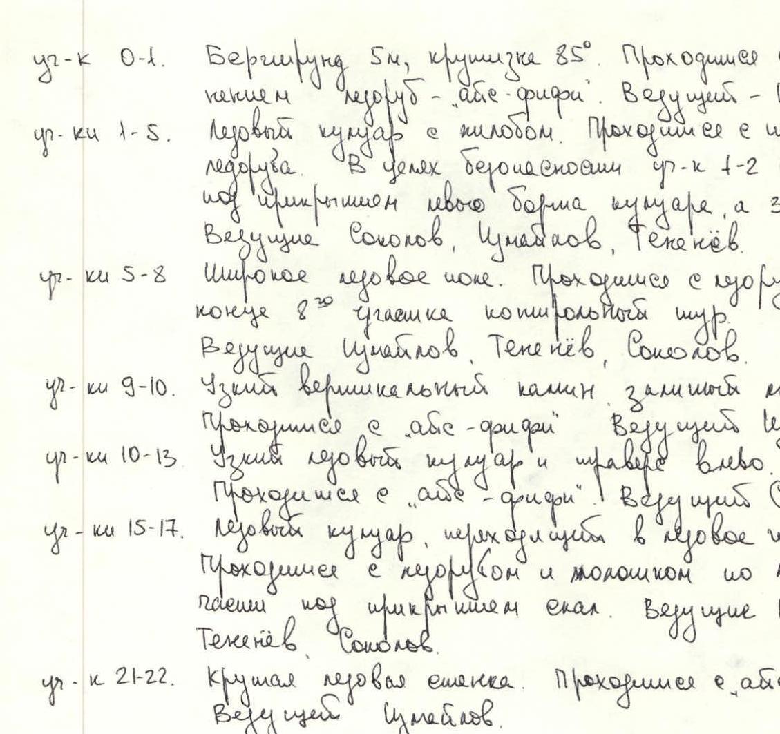
Section R0–R1. Bergschrund 5 m, steepness 85°. Passed using "ice axe — abs-fifi". Lead — Shevchenko. Sections R1–R5. Ice couloir with a kink. Passed using an ice screw. For safety, R1–R2 was passed under the cover of the left couloir wall, and R3–R4 — the right. Leads: Sokolov, Izmaylov, Tenenyev. Sections R5–R8. Wide ice field. Passed using an ice axe. At the end of the R7–R8 section, a control cairn. Leads: Izmaylov, Tenenyev, Sokolov. Sections R9–R10. Narrow vertical chimney filled with ice. Passed using "abs-fifi". Lead Izmaylov. Sections R10–R13. Narrow ice couloir and traverse left. Passed using "abs-fifi". Lead Sokolov. Sections R15–R17. Ice couloir turning into an ice field. Passed using an ice axe and hammer along the left undercut under the cover of rocks. Leads: Izmaylov, Tenenyev, Sokolov. Section R21–R22. Steep ice wall. Passed using "abs-fifi". Lead Izmaylov. On all sections R0–R24, belay was alternating with the organization of fixed ropes.