- Climbing category — technical
- Climbing area — Central Tian-Shan, Teskey Ala-Too ridge, Jety-Oguz gorge
- Summit — Keldysh Peak, 4430 m, ascent route via the North Ridge from Ayilama Pass
- Estimated category difficulty: 4A
- Route characteristics: height difference — 766 m, length of sections with IV–V category difficulty — 660 m, average steepness 48°
- Pitons used: rock anchors — 12, ice screws — 34, bolt anchors — 0
- Total climbing hours — 15
- Number of nights and their characteristics — 0
- Surname, first name, patronymic of the leader, participants, and their qualification: BIKMUKHAMEDOV Ilyas Sh. — leader, 1st sports category BELNITSKAYA Galina Ivanovna — participant, 2nd sports category Zavarzin Yury Timofeevich — participant, 2nd sports category TESLENKO Sergey Tikhonovich — participant, 2nd sports category ZHELIBA Evgeny I. — participant, 2nd sports category
- Team coach BIRYUKOV V.N.
- Date of departure to the route — August 15, 1978 Date of return from the route — August 15, 1978
Keldysh Peak 4430 m
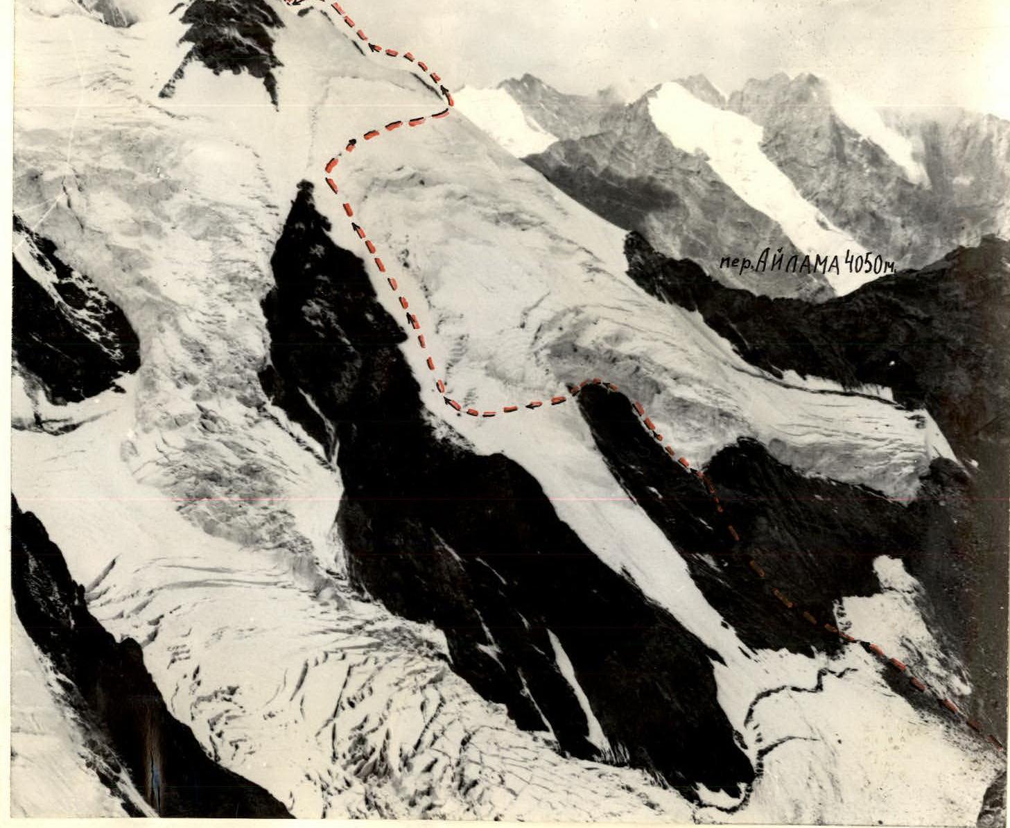
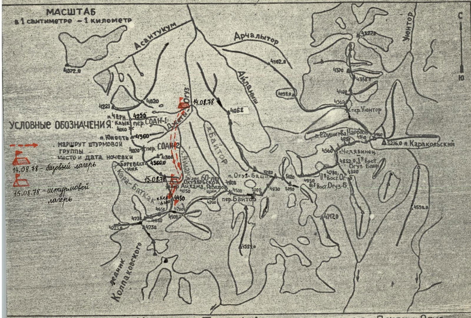
Map of the axial part of the Teskey Alatau ridge in the upper reaches of the Jety-Oguz river. Keldysh Peak — 4430 m (the height of the peak is given based on a 1:100,000 topographic survey published in 1962) is located in the northern spur of the Teskey Ala-Too watershed ridge in the upper reaches of the left tributary of the Jety-Oguz river — the Baitor river (see map).
From Przhevalsk, take a bus to the "Jety-Oguz" resort. Then, along the Jety-Oguz gorge, follow the road to the Telety gorge. Slightly above the Telety tributary, it is convenient to set up a base camp. Then, on foot, along the Jety-Oguz gorge, to the fork leading to the Baitor gorge. Ford the river, then cross over a log to the left bank of the Jety-Oguz river. (It is possible to cross to the left bank of the Jety-Oguz river immediately at the Telety campsite.) Along the Baitor gorge to the fork, then along the left bank of the Baitor river, ascend to the Baitor campsite. The entire route follows a horse trail. From Telety to the Baitor campsite takes around 4–5 hours with full backpacks. The campsite has clean water and is a good grassy area. From the campsite, it takes 2–2.5 hours of walking: — across grassy slopes, — along the left bank of the river, — across the moraine under the route. The route is partially not visible from the campsite.
Thus, the approach to the route takes: — 2 hours by car, — 6–7.5 hours on foot, i.e., one full working day.
TABLE OF MAIN CHARACTERISTICS OF THE ASCENT ROUTE
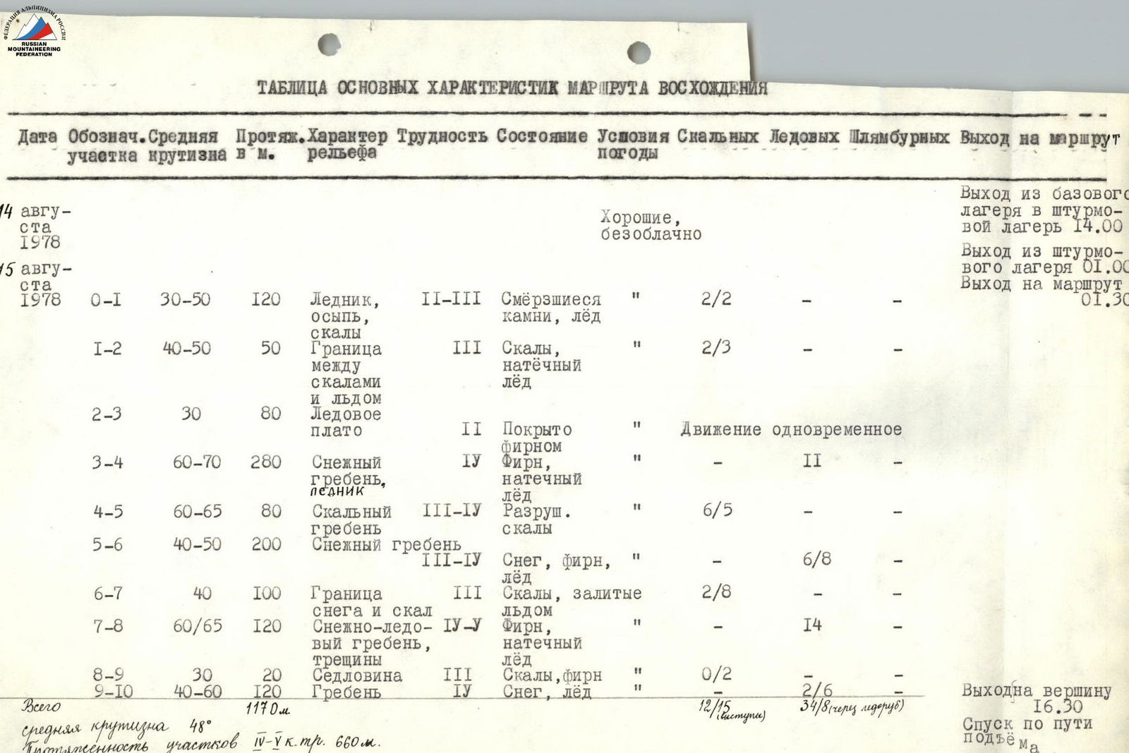
Brief explanation of the table
R0–R1. Approach via scree and rocks to the boundary between the rocks and the vertical ice wall. R1–R2. Boundary between rocks and glacier. Ascend along the boundary to the ice plateau. R2–R3. Across the ice plateau with seracs, through a snow bridge to the snowy ridge on the left. R3–R4. Ascend along the snowy ridge above the bergschrund and above the rocky outcrop, above Ayilama Pass, between the icefall and rocks. R4–R5. Move along the steep rocky ridge at 60–65°. There are sections with regelation ice. R5–R7. Reach the snowy-icy part of the ridge, bypass the third rocky outcrop from below. R7–R8. Ascend to the first (western) summit along the ridge. This section requires particularly careful belaying. R8–R10. Descend from the western summit and ascend to the eastern summit along the snowy-icy ridge.
It is recommended to start early from the assault camp. (On the saddle between the summits, on a rocky-icy platform, it is possible to organize an overnight stay.)