Ascent Passport
-
Ascent class — technical
-
Ascent area — Central Tien Shan, Teskey Ala-Too range, Jety-Oguz gorge
-
Peak — Peak Burevestnik, 4360 m, ascent route — via North-Eastern ridge
-
Estimated difficulty category 4B
-
Route characteristics:
height difference — 514 m, length of sections IV–V cat. diff. — 320 m, average steepness 55°
-
Pitons driven:
rock protection — 33, ice — 2, bolted — 0
-
Number of travel hours — 14
-
Number of overnight stays and their characteristics — 0
-
Surname, name, patronymic of the leader, participants, their qualification:
SAMOKHVALOV Anatoliy Vladimirovich — participant, 1st sports category, YEVSEYENKO Tatyana Pavlovna — participant, 2nd sports category
-
Team coach — BIRYUKOV V.N.
-
Date of departure on the route — August 7, 1978
date of return from the route — August 7, 1978

Chairman Azov

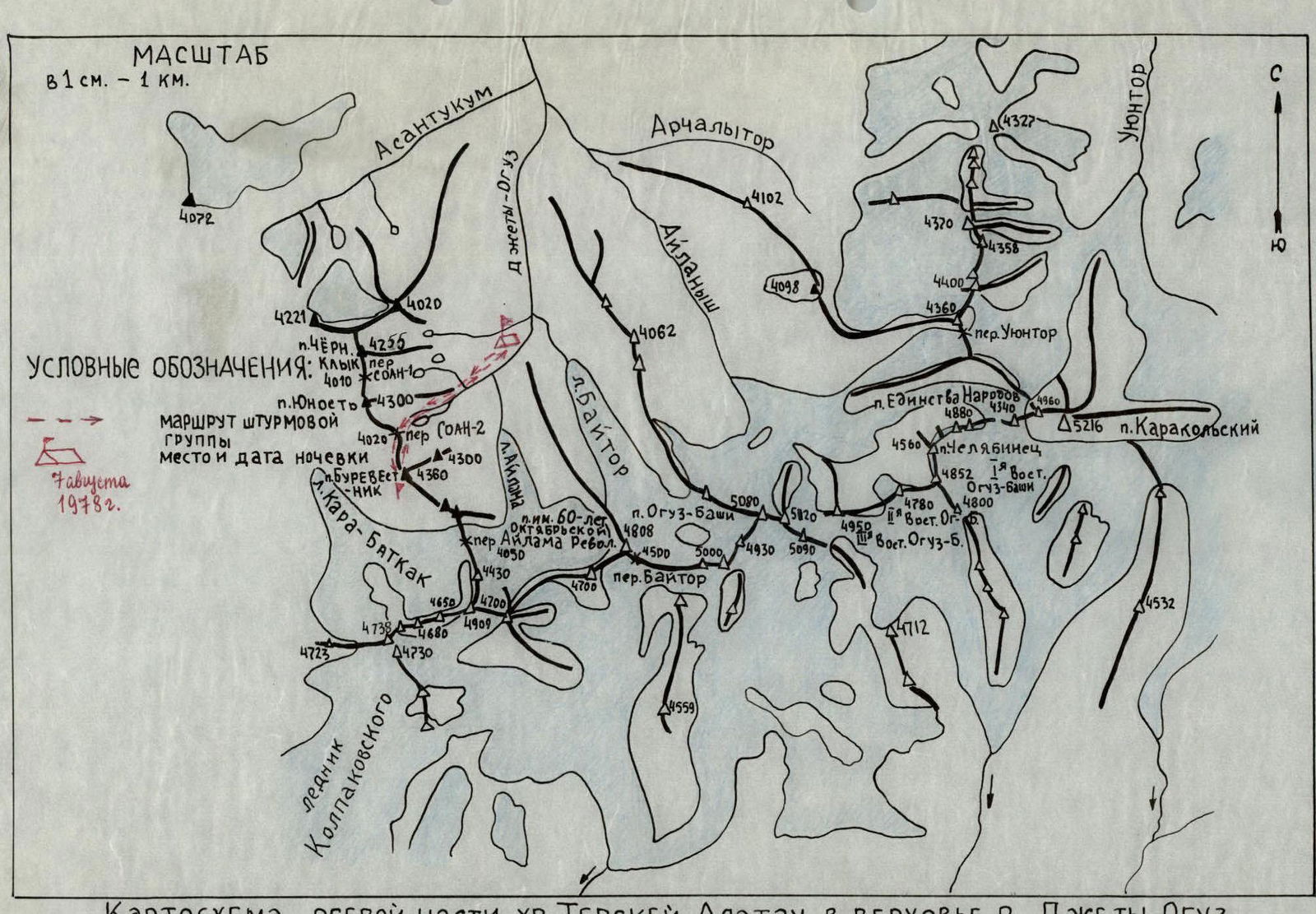
Schematic map of the axial part of the Teskey-Ala-Too range in the upper reaches of the Jety-Oguz river.
Brief description of approaches to the route
Peak Burevestnik (4360 m) is located in the northern spur of the Teskey-Ala-Too watershed range in the upper reaches of the left tributary of the Jety-Oguz river — Baytor river, in the left part of the Baytor gorge (see schematic map).
The height of the peak is given based on a topographic survey at a scale of 1:100,000, published in 1962.
From Przhevalsk city by bus to the "Jety-Oguz" resort, then along the Jety-Oguz gorge by road to the Telety gorge (12 km). Then on foot along the Jety-Oguz gorge to the fork leading to the Baytor gorge. Ford to the left bank of Jety-Oguz, then cross a log to the left bank of the Baytor tributary. It is possible to cross to the left bank of the Jety-Oguz river immediately at the Telety campsite.
Along the Baytor gorge to the fork, then along the left bank of the tributary ascend to the Baytor campsite.
Movement is everywhere along a horse trail, from Telety to Baytor campsite is about 5–6 hours with full backpacks.
The campsite has clean water, and the entire site is a good grassy area.
From the campsite, it takes 2–3 hours of walking along grassy slopes and moraine to reach the route. From the campsite, only the middle part of the route is visible.
Thus, the approaches to the route take:
- 2 hours by car,
- 7–9 hours on foot, i.e., one full working day.
Table of main characteristics of the ascent route
| Date | Section | Average steepness, ° | Length, m | Terrain type | Difficulty category | Condition / Weather conditions | Rock | Ice | Bolted | Note |
|---|---|---|---|---|---|---|---|---|---|---|
| August 7, 1978 | R0–R1 | 60 | 200 | Couloir | 2–3 | Clean rocks | 2/6 | – | – | Departure from camp at 3:00. Route start at 5:00. |
| R1–R2 | 30 | 120 | Narrow ledge | 2 | Clean | 0/10 | – | – | ||
| R2–R3 | 70–85 | 20 | Chimney | 4–5 | Iced over | 3 | – | – | ||
| R3–R4 | 35–45 | 90 | Ridge | 3 | Clean rocks | 3/6 | – | – | ||
| R4–R5 | 60–70 | 180 | Wall | 4 | 8/10 | – | – | |||
| R5–R6 | 75–80 | 80 | Ridge | 4 | Broken rocks | 5/6 | – | – | ||
| R6–R7 | 30–40 | 140 | Ridge | 3 | 2/10 | – | – | |||
| R7–R8 | 60–80 | 40 | Wall | 4–5 | Clean rocks | 6 | – | – | ||
| R8–R9 | 30–40 | 100 | Ridge | 3 | Broken rocks, ice | 2/8 | – | – | ||
| R9–R10 | 30–50–70 | 300 | Ridge | 3 | 2/15 | 2 | – | Reach the summit at 19:00. Descent via 3A. | ||
| Total | 1270 | 33/71 | 2 | – |
Average steepness 55°. Length of sections IV–V cat. diff. 320 m. Notation: numerator — rock pitons, denominator — rock features.
Brief explanation of the table
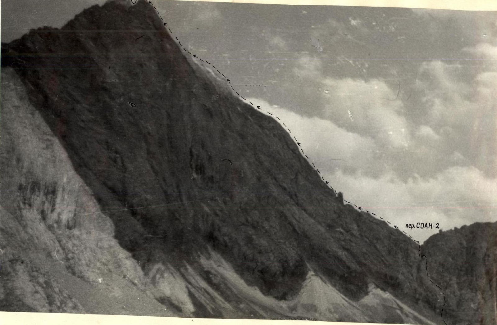
R0–R1 Ascent to the SOAN-2 pass is not difficult. First, along wide ledges in the right part of the couloir under a wall with a steepness of 80°–90°, height 10 m. Then along the wall to the pass. R1–R2 From the pass along ledges to the right of the ridge. On the ledges, there are places with built-up ice. R2–R3 Ledges lead to the "Finger" gendarme. Here is a 10-meter chimney leading to the ridge. R3–R5 Then along the ridge to the wall. Rocks are местами iced over. In the upper part, the steepness of the wall increases to 80°. R5–R8 The ridge is heavily serrated and broken. At the end of section R7–R8, there is a wall. R8–R9 The ridge is sharp, heavily serrated, and местами iced over. R9–R10 Broken rocks. The ascent to the summit is along a gentle snow-ice slope, then along rocks.
Descent is along route 3A under the Southern ridge.