PASSPORT
I. Class — ice and snow
- Tian-Shan, Terskey Ala-Too, Baytor gorge
- Peak "20 let gazety 'Komsomolets Kirgizii'" (4700 m) via the right part of the north face, ice and snow route
- Proposed — 5B category of difficulty, second ascent
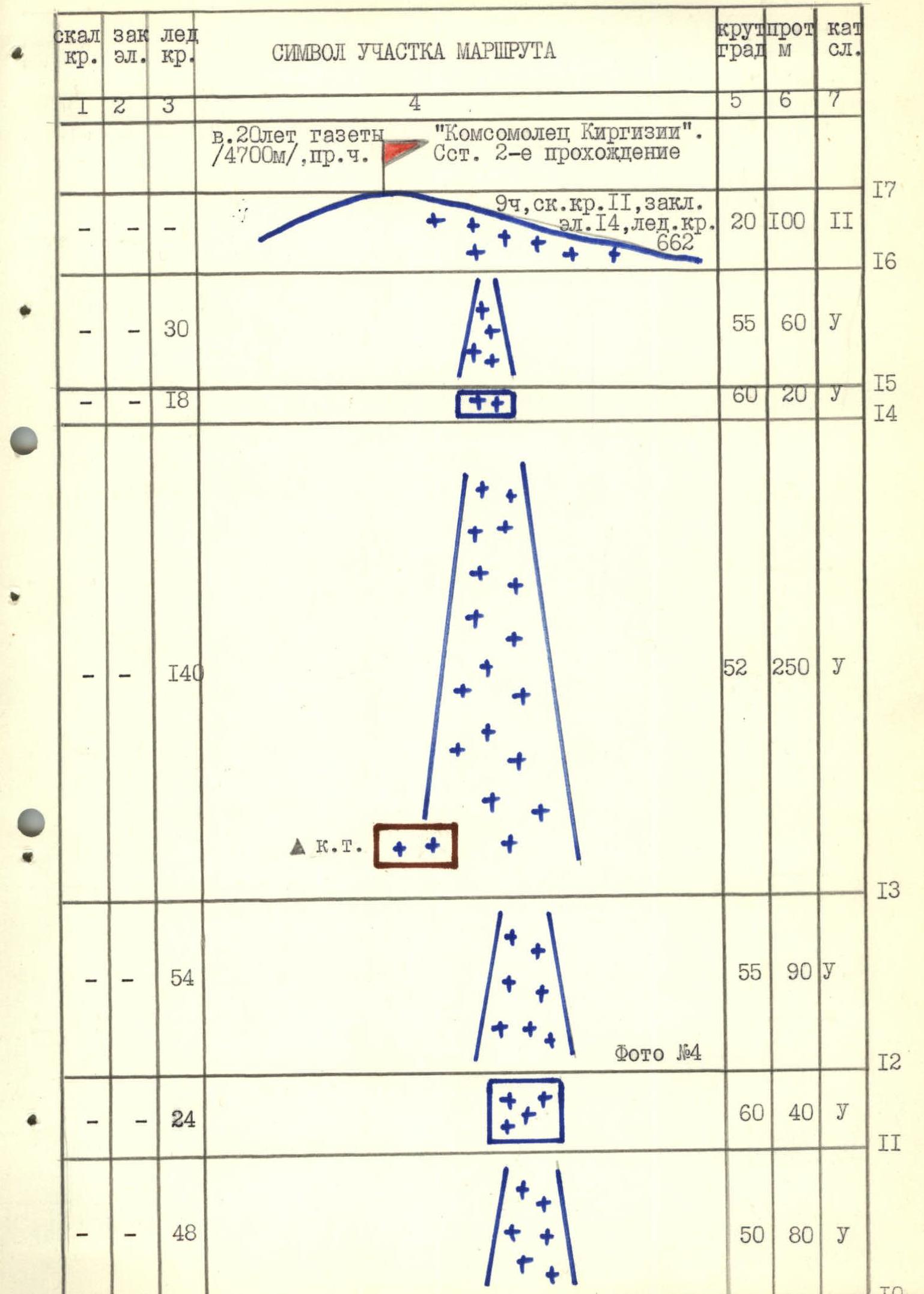
- Height difference — 1050 m, length — 1350 m
Length of sections with 5th category of difficulty — 1100 m. Average steepness of the main part of the route — 52°
- Pitons driven:
- rock — 2
- bolt — 0
- chocks — 14
- ice — 662
- Team's climbing hours: 9 h 00 min
- Overnight stays — none
- Team leader: Tumyalis Vladimir Vitalius, Master of Sports Team members:
- Kozhemyako Nikolay Grigorievich, Candidate for Master of Sports
- Plotnikov Ivan Aleksandrovich, Candidate for Master of Sports
- Stalkovskiy Vladimir Viktorovich, Candidate for Master of Sports
- Tenenev Valentin Alekseevich, Master of Sports
- Foigt Aleksandr Vadimovich, Candidate for Master of Sports
-
Coach: Shevchenko Nikolay Alekseevich, Master of Sports
-
Start of the route: August 15, 1988, 5:00 AM. Summit: August 15, 1988, 2:00 PM. Return: August 15, 1988, 6:00 PM.
-
Organization — RSFSR State Committee for Sports
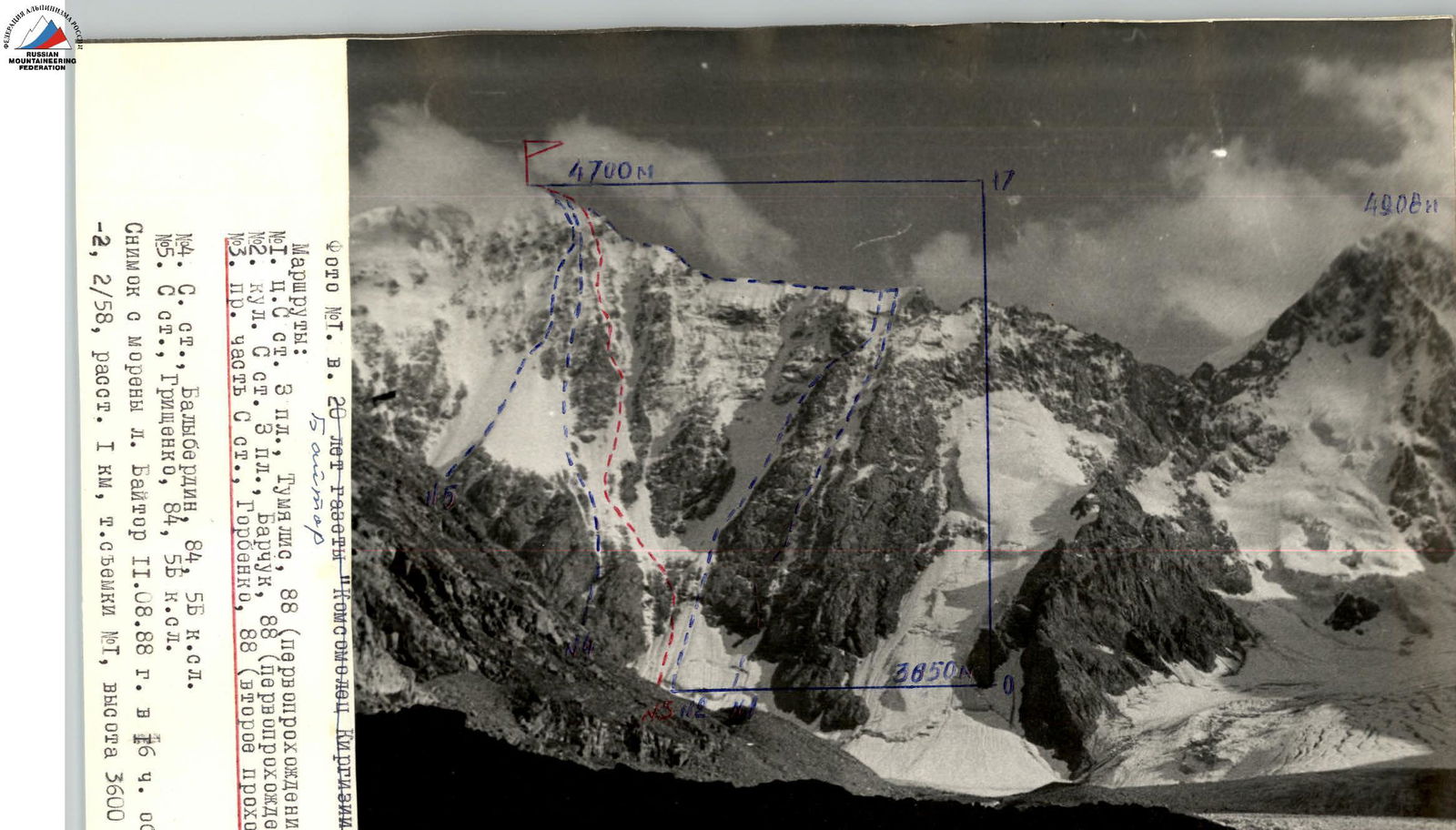
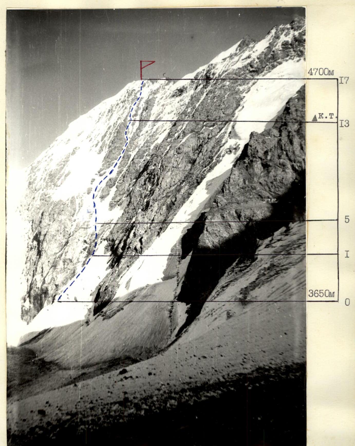
PHOTO #2. PROFILE OF THE WALL FROM THE RIGHT. The picture was taken from the west from the Baytor glacier moraine on August 12, 1988, at 5:00 PM, lens — HELIOS-44-2, 2/58. Distance 0.5 km, shooting point #2, shooting height 3600 m.
Tactical actions of the team
RSFSR-2 during the ascent to peak "20 let gazety 'Komsomolets Kirgizii'" via the right part of the north face. Second ascent, 5B category of difficulty, achieved within the framework of the USSR Alpine Championship (ice and snow climbing class).
Route selection
The team chose the same route as the first team for the second object of ascent in the first round.
Equipment selection
Based on the route's characteristics and the analysis of the ascent by the "Odessa" team, the corresponding ice and rock equipment was selected (see route sheet).
Characteristics of sections and tactical actions of the team
The team started the route on August 15, 1988, at 4:30 AM from the assault camp located on the Baytor glacier moraine. The approach to the route took 30 minutes.
Section R0–R1
At 5:00 AM, the group crossed the bergschrund via a snow bridge. Then — movement under the rock belt on an ice board with a steepness of 40–45°, allowing movement in the dark with flashlights.
- Autonomous rope teams: Tenenev — Plotnikov, Tumyalis — Kozhemyako, Foigt — Stalkovskiy
- Movement on a shortened UIAA rope (20 m) with changing leads
- Belaying via ice screws
At 6:00 AM, the group reached under the rock belt.
Section R1–R5
It is a belt of shattered rocks, consisting of a series of ledges and internal corners. In the middle part, it is covered with a thin layer of rolling ice. The start of movement on this section was at 6:00 AM, as it begins to get light at this time.
- The first on a double rope works Stalkovskiy, the last — Tenenev
- Belaying via rock pitons and chock stones
Section R5–R13
It is an ice board with a steepness of about 50°, bounded on the left and right by rock ridges. There are two ice rises with a steepness of up to 60°.
- Movement in autonomous, parallel rope teams with changing leaders
- Belaying via ice screws
At 11:00 AM, the group reached the control point.
Section R13–R16
It is an ice board dissected by a rock ridge in the upper part. When approaching the rock ridge, there is an ice wall with a steepness of up to 65°.
- Movement and belaying similar to the previous section
At 1:45 PM, the first rope team reached the pre-summit ridge.
Section R16–R17
Pre-summit snow and rock ridge, 2nd category of difficulty. Simultaneous movement, belaying using the terrain. At 2:00 PM, the group reached the summit. Throughout the entire route, the group wore crampons, and used ice axes on ice sections.
Weather conditions
Around 10:00 AM, the weather deteriorated. Snowfall began, and wind picked up. Visibility up to 40 m. The group was working on section R12–R13 at this time.
The large amount of precipitation caused the formation of snow rivers flowing down the ice board as a continuous stream. Unfavorable conditions persisted until the descent to the base camp.
The deterioration of weather conditions did not affect the speed and safety of the group's ascent.
Radio communication and observation
Observers: Shevchenko N.A., Ostrikov P.V., constant observation through a 30×60 telescope. Radio communication was stable at the planned time. Emergency listening — every hour starting from 6:00 AM.
Safety measures
The time of starting the route was determined by the need to pass the rockfall-prone section in the early, cold hours of the day. We believe that it is most advisable to start moving on the rock section at 6:00 AM, when it starts to get light.
Places for stations on rocks were chosen under the protection of cornices. Stations were organized on:
- blocked rock pitons
- chock stones.
Parallel movement of rope teams on shortened ropes on ice sections ensured a minimal probability of being hit by ice fragments from above.
The group was provided with bivouac equipment and a supply of food for two days in case of moving along an alternative route.
The route was completed according to the planned path without deviations. There were no falls or injuries to participants.
Team captain: Tumyalis V.V.
Team coach: Shevchenko N.A.
UIAA SYMBOLS ROUTE MAP 1:2000