Passport
- Ice and snow class
- Tian-Shan, Terskey Alatoo, Jetyoguz valley
- p. Baitor, 4700 m, right part of the North face
- Proposed – 5B–6B category of difficulty, first ascent
- Height difference: 1050 m, route length – 1510 m, face – 1360 m, length of V–VI category sections – 1000 m, including 6 category – 70 m
- Average steepness of the main part of the route – 54°
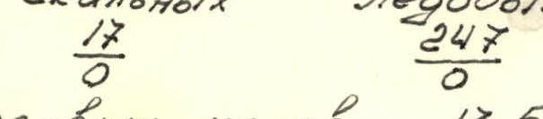
- Pitons: rock – 17, ice – 247.
- Climbing hours – 13.5
- Overnight stays: none.
- Team leader – Gorbenco Metislav Mstislavovich, Master of Sports of International Class Team members: Sitnik Mikhail Alexandrovich, Master of Sports Alperin Vladimir Maevich, Master of Sports Leontiev Vadim Gennadievich, Master of Sports Erohin Oleg Valerievich, Master of Sports Haraldin Alexey Viktorovich, Candidate Master of Sports
- Senior coach – Sviridenko Vadim Sergeevich, Honored Coach of Ukrainian SSR Coach – Gorbenco Metislav Mstislavovich
- Departure on the route – August 12, 1988 Summit – August 12, 1988 Return – August 12, 1988
- Organization: Regional Alpine Club, "Odessa".
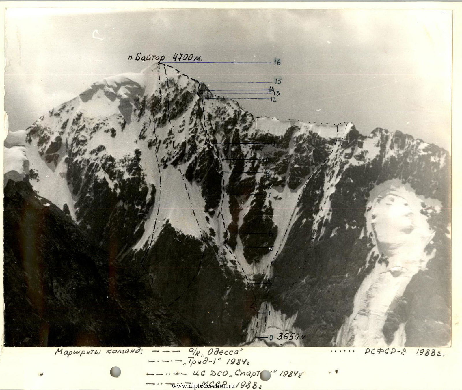
4700 m
Routes of teams: "a/k Odessa" ....... RSFSR-2 1988 "Trud-1" 1984 "4S DSO, Spart" 1984 www.alpfederation.ru/9382↗

Tactical actions of the team
Before the ascent, the group conducted reconnaissance to choose a route, identify hazardous and key areas. A detailed tactical plan for the ascent was developed. Directly before starting the route, observations were made throughout the day, allowing for adjustments to the route.
The ascent proceeded largely according to the tactical plan, with a slight lead.
The planned overnight stay on the descent from p. Baitor was moved down to the lateral moraine of the glacier (to the assault camp of the "V. Tsey" team), as a trail was beaten from the pass, allowing a descent of 2 hours in height and a night's stay in normal conditions.
To avoid possible rockfall at the start of the route (sectors R0–R4), the group began moving at night (2:30), in lower temperatures, using headlamps.
Movement was carried out by independent rope teams with alternate belays. On the rocks, for safety and to speed up movement, fixed ropes were used. To ensure safety in the ice couloir, the group moved under the cover of the left side rocks until the slope was lit by the sun (around 13:00) above the couloir. Then, along the ice slope of the ridge and the ice crest to the exit onto the pre-summit ridge.
To avoid minor injuries from ice fragments during movement, the group moved at a slight angle to the belay points. Ski goggles covering most of the face proved effective.
Belaying was done using a GUAA rope or on a double VISA rope. The first rope team organized intermediate belay points, which were later used by the second and third rope teams. The leading rope team changed periodically.
Rope team composition: – Gorbenco – Sitnik – Leontiev – Alperin – Erohin – Haraldin
The change of leaders on the route by sections was as follows: Gorbenco M.M. R0–R1, R4–R6, R9–R11. Sitnik M.A. R1–R4, R13–R15. Leontiev V.G. R11–R13 Alperin V.M. R11–R13 Erohin O.V. R6–R8 Haraldin A.V. R8–R9 The group started moving at 2:30, reached the summit at 17:30 (1st rope team at 17:00), descended to the glacier by 22:00 via the eastern ridge through p. Baitor, where they spent the night on the moraine. Climbing time was 13.5 hours, descent – 4 hours.
Overcoming the ice terrain was done using rigid crampons and ice axes (ice hammers) and one "ice-fee". Key points – two "ice-fee".
For rest, nutrition, and replenishment of the water-salt balance after 10 hours of work on the route, a gas stop was planned at a convenient location. The group was equipped with easily digestible high-calorie food (personal "pocket" and shared), a light gas stove. In case of a possible bivouac due to worsening weather, the group had a tent and a supply of warm clothing. During the ascent, the group was under visual observation. Regular radio communication was maintained using PLC "Bosch" (FRG). The ascent was supported by a combined rescue team from the a/k "Odessa" and MSAR.


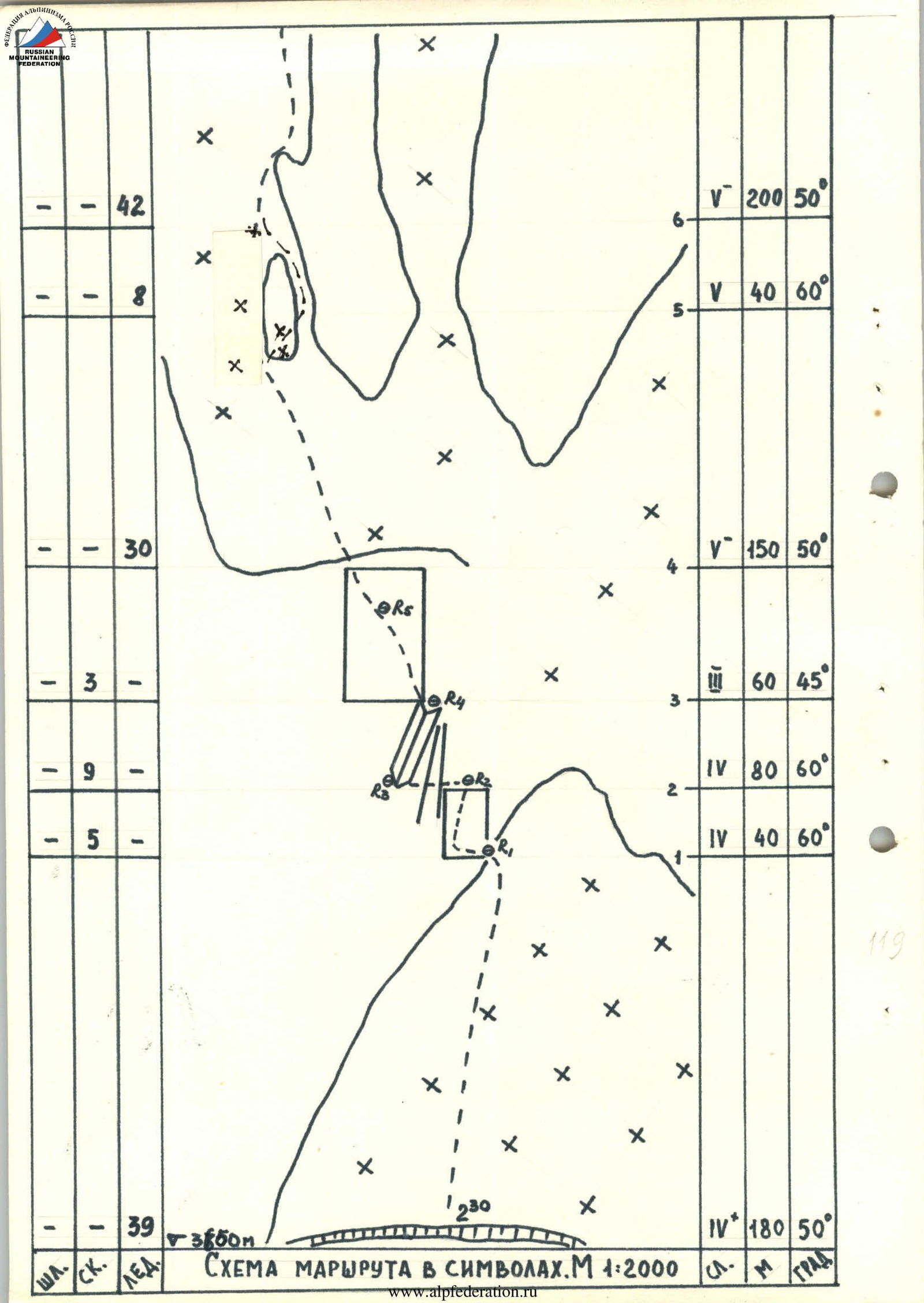
Route diagram in symbols. Scale 1:2000
| Category of difficulty | Length, m | Angle, degrees |
|---|---|---|
| V | 200 | 50° |
| V | 40 | 60° |
| III | 60 | 45° |
| IV | 80 | 60° |
| IV | 40 | 60° |
| IV+ | 180 | 50° |
Note: the diagram indicates points R1–R5, as well as the mark 3850 m and time 2:30.


