PASSPORT
I. High-altitude category.
- Central Tian Shan, Tengri Tag ridge.
- Peak Zapadny Shatyor, via the Southwest Ridge of the South Ridge, 6740 m.
- Proposed - 6A category of difficulty, first ascent.
- Height difference - 1840 m; length - 3428 m; length of sections with 5th category of difficulty - 240 m; average steepness of the southwest ridge - 48°.
- Pitons driven: rock - 4; ice - 30; chocks - 2.
- Team's travel hours - 24, days - 3.
- Overnight stays - in a tent on a shelf under a rock.
- Team leader - Sokolov Sergey Alexandrovich, Candidate Master of Sports; participants: Bashmanov Yuriy Viktorovich, Candidate Master of Sports, Gadeev Ravil Gareyevich, Candidate Master of Sports, Dorro Konstantin Eduardovich, Candidate Master of Sports, Nagovitsyna Elena Yulyevna, Candidate Master of Sports, Khudyakov Andrey Viktorovich, Candidate Master of Sports.
- Coach - Denisov Valeriy Grigoryevich, Master of Sports.
II. Departure on the route - August 18, 1995; summit - August 20, 1995; return - August 21, 1995.
- Organization - Alpine Federation of Dagestan; Alpine Federation of Kyrgyzstan;
Goskomtur of Kyrgyzstan.
- route Southwest ridge of the South Ridge of peak Zapadny Shatyor
- path to the route photo shooting point #1 on the Demchenko Glacier.
Brief Overview of the Climbing Area
The peak Zapadny Shatyor is located in the most inaccessible and rarely visited corner of the eastern part of Central Tian Shan, beyond Khan Tengri Peak in the upper reaches of the South Inylchek Glacier. The South Inylchek Glacier area is well-known in alpinism and frequently visited. Two famous peaks are located here: Khan Tengri and Pobeda, climbing which is the cherished dream of most alpine expeditions coming here. Therefore, the description of approaches and the area itself is well-known and well-reflected in the relevant literature and reports. Information about the upper reaches of the South Inylchek Glacier is scarce, and materials on ascending the peaks Zapadny and Vostochny Shatyor from the south were not found by us in the literature. Therefore, during preparation for the ascent, preliminary reconnaissance was conducted in the area of the Razorvanny Glacier, from which the peak Zapadny Shatyor is well observed.
From the base camp at 4100 m on the moraine under M. Gorky Peak to the Razorvanny Glacier, one can reach by moving up the South Inylchek Glacier, sticking to the right bank of the large stream flowing in the center of the glacier. Above the Semenovsky Glacier, there are many snow-covered crevasses. The Razorvanny Glacier fully justifies its name and in its lower southern part represents an icefall with chaotic jamming of crevasses. Attempts by two groups to bypass the Razorvanny icefall from the right and left to reach the saddle of the Tengri Tag ridge were unsuccessful. In the left variant, the group was stopped by a very wide crevasse, as well as the danger of avalanches from the eastern slopes of Khan Tengri. And when bypassing the glacier from the right, it was possible to go only to the foot of a steep slope of a small mountain, which was conditionally named "Manasyonok" by the expedition participants. Further movement through the chaos of the Razorvanny icefall threatened to take time away from the entire expedition. But this variant revealed the possibility of approaching the proposed ascent route to peak Zapadny Shatyor - the Southwest Ridge of the South Ridge.
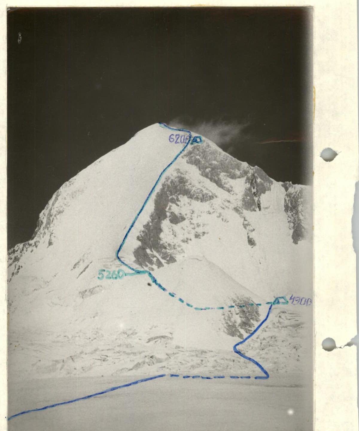
The mountain "Manasyonok", the Southwest Ridge, and the South Ridge of peak Zapadny Shatyor, steep slopes of the nameless peak 5462 m form a closed cirque with a single exit to the west, where a hanging icefall is bounded by the slopes of "Manasyonok" to the north and a wall to the south.
 Profile of the southwest ridge on the right, photo taken from the cirque at point #2 (4900 m).
The peak 5462 m descends downwards, adjoining the Razorvanny Glacier from the side. Moving along the snowy slopes of the "Manasyonok" mountain on the border with the lateral icefall, first by traversing under the rocks, and then up the steep slope, we enter the cirque - a convenient and safe place for setting up a camp before starting the route to peak Zapadny Shatyor.
Preparation for the Ascent
The ascent to peak Zapadny Shatyor was conducted in honor of the 1000th anniversary of the epic "Manas". The final team composition was determined after a reconnaissance trip to the area of peak Zapadny Shatyor. All team members had sufficient alpine experience and engaged in general physical and technical training according to individual training plans. By the time of departure for the ascent, all team members had experience with climbs of 5th category of difficulty in this season, and joint training ascents were also conducted. Due to such preparation, all team members were in excellent physical shape and well-acclimatized.
After conducting preliminary reconnaissance, observations, and video filming during the flyover of the area around peak Zapadny Shatyor by helicopter, the ascent route was finally chosen - the southwest ridge of the south ridge, a first ascent. Preference was given to this route due to its logic, beauty, sufficiently high technical complexity, and safety, as well as the possibility of approaching and setting up a safe camp before the start of the route.
When drawing up the tactical plan, the following factors were considered: the availability and location of overnight stays; the possibility of processing the start of the route; the location of key areas and предполагаемые варианты их преодоления; meteorological conditions. Unstable weather, snow, strong wind can be considered specific to this area. The possibility of overnight stay only when reaching the south ridge (6200 m) dictated the condition of passing the southwest ridge in one day. One day, especially in bad weather conditions, might not be enough to reach this ridge, and preliminary processing of the route was planned in the tactical plan of the ascent.
Measures to ensure safety during the passage of the route included the presence of a highly qualified rescue team in the area from members of the "Manas-1000" expedition and mountain guides from "MATC Tian Shan", an observation group in the camp under the route (4900 m), stable radio communication with the base camp and the observation group. The camp under the route had a sufficient supply of food, gasoline, gas, additional equipment - ropes, ice screws, carabiners, ice axes, etc., most of which were dropped during the preliminary reconnaissance and a snow cave was dug at that time.
Tactical Actions of the Team
The ascent took place from August 18 to August 21, 1995. On August 18, as planned according to the tactical plan, the team processed the route. When exiting the cirque onto the saddle under the start of the southwest ridge (section R1-R2) on a steep icy slope, two ropes were hung, and on the section R0-R1, where movement was alternating or simultaneous, well-trodden tracks remained in the deep snow, with the hope that they would remain until the next morning. Further, at the beginning of the southwest ridge (section R3-R4), one rope was hung through a system of crevasses and onto a vertical wall of the bergschrund 6 m high. Two rope teams participated in the preliminary processing of the route: Sokolov-Dorro and Gadeev-Nagovitsyna. The first team took turns leading the way.
On August 19 at 5:30 am, the group departed from the camp in the cirque (4900 m) onto the route. Movement was in two rope teams: Sokolov-Dorro-Bashmanov and Gadeev-Nagovitsyna-Khudyakov, alternating or simultaneous depending on the steepness of the slope and the thickness of the snow cover over the icy base, with insurance through an ice axe or ice screws. The second rope team worked first on the route (photo #3).
At 7:30 pm, the group reached the rocks 60 m below the ridge, where under an overhanging rock wall there was a site for tents for an overnight stay (6200 m). The site for two tents was a bit narrow (1.5 m), but was more or less protected from a very strong wind by rocks. Below the site, there was a steep, precipitous slope; insurance on the site was provided by ropes on rock pitons and ice screws. The weather was very changeable throughout the day: sometimes sunny, sometimes snowing with strong wind. On the south ridge, there was almost incessant hurricane-force gusty wind. There were enough places for overnight stays, but there was doubt whether the tents would withstand.
On August 20 at 9:00 am, the group departed in the same two rope teams along the south ridge and at 3:00 pm, on the summit, in rocks to the southwest of the snowy dome, an iron capsule with the text of the Manas declaration, a book "Manas", and a note with the list of participants was laid in a cairn. The weather was unstable, as on the previous day, with very strong wind. On the ridge, there were many snow-covered crevasses. Movement was simultaneous or alternating, with the first team leading on the ridge. The descent from the summit followed the ascent route along the ridge and an overnight stay in the same camp at 6200 m.
On August 21, there was a descent down the ascent path; movement was alternating; insurance was through an ice axe and ice screws. The weather was sunny, with sticky snow in the lower part of the route.
There were practically no deviations from the tactical plan. Communication with observers and the base camp was carried out using a Japanese radio station. There were no accidents or injuries during the ascent and descent.
Description of the Route by Sections
The start of the route is a snow-ice slope in the northern part of the cirque (4900 m), leading to a saddle between the southwest ridge and the "Manasyonok" mountain. The lower part of the slope (section R0-R1) - deep fresh snow, crevasses, the upper part (section R1-R2) - a steep icy slope intersected by two crevasses 0.5-1.5 m wide, on this section movement is alternating on ropes.
The saddle (section R2-R3) represents a snowy ridge with a cornice and closed crevasses. It is possible to organize overnight stays, but unlike the camp in the cirque, it is constantly windy here. Section R3-R5 - a snow-ice slope of average steepness, intersected by several crevasses, the last of which - the bergschrund - has a vertical wall 8 m high. Further, the entire southwest ridge to the rocks represents an ice-snow slope with a steepness of 35-50° with individual short icy sections of great steepness - 55-60°. The depth of snow on the icy slope varies significantly from 0.5 m to several centimeters. Especially soft and loose snow was found before exiting onto the rocks (section R11-R12). Section R12-R13 represents an icy slope with rock islands, turning into a rock mass to the right. At the end of the section (to the right 15 m), under an overhanging rock, there is a shelf for an overnight stay (6200 m), safe, sheltered from the wind, but not comfortable due to the narrowness of the site. The exit to the ridge (section R13-R14) - strongly destroyed snow-covered rocks, between rocky sections - steep ice.
The south ridge leading to the summit is technically not complex, but there are many closed crevasses on it, with snow cornices on the edges of the ridge. It requires attentiveness when descending from the pre-summit pinnacle, as a snow cornice overhangs a steep snowy-icy slope intersected by a wide crevasse (section R19-R20). The exit to the summit of Zapadny Shatyor (6740 m) - after descending from the pinnacle, an ascent along a snowy-icy slope, with very loose snow, steps holding poorly, insurance through an ice axe. The main obstacle when moving along the south ridge is a strong gusty wind, which together with snow and ice hits the face. The altitude marks of the camps on the route and the summit were determined by a handheld altimeter.
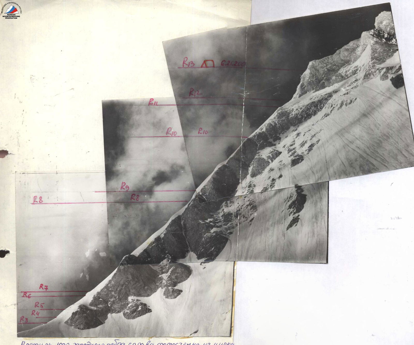
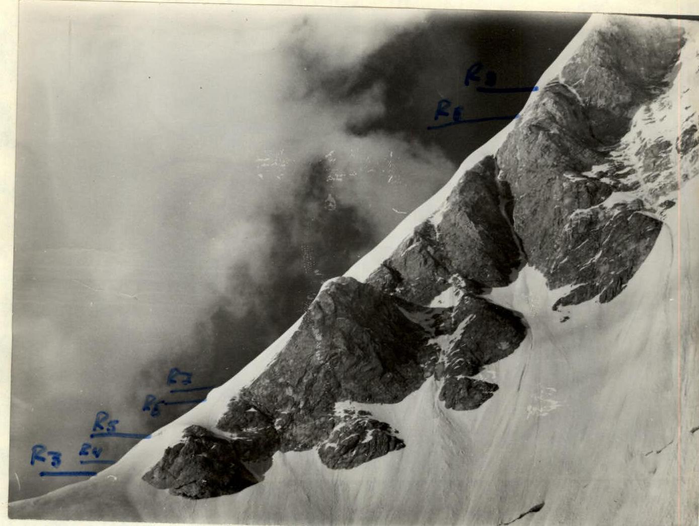 Photo #1 Southwest ridge sections R5-R9, photo taken from point #2 (cirque 4900 m).
Route Diagram
Characteristics of the route angles
| Section | Length, m | Steepness | Category of difficulty |
|---|---|---|---|
| R22 | 110 | 20–30° | 2 |
| R21 | 200 | 45–50° | 4 |
| R20 | 25 | 60° | 4–5 |
| R19 | 70 | –55° | 4–5 |
| R18 | 110 | 45° | 3 |
| R17 | 180 | 10–15° | 2 |
| R16 | 150 | –20° | 2 |
| R15 | 80 | 40–45° | 3–4 |
| R14 | 700 | 20° | 2 |
| R13 | 45 | 70° | 5 |
| R12 | 110 | 65–70° | 4–5 |
| R11 | 45 | 35° | 3–4 |
| R10 | 170 | 40–45° | 3–4 |
| R9 | 280 | 45–50° | 4 |
| R8 | 35 | 60° | 4–5 |
| R7 | 460 | 45–50° | 4 |
| R6 | 15 | 65° | 4–5 |
| R5 | 80 | 35° | 3 |
| R4 | 70 | 35–45° | 4 |
| R3 | 70 | 35–45° | 4 |
| R2 | 120 | 15–20° | 3 |
| R1 | 70 | 60–65° | 4 |
| R0 | 280 | 45° | 3 |
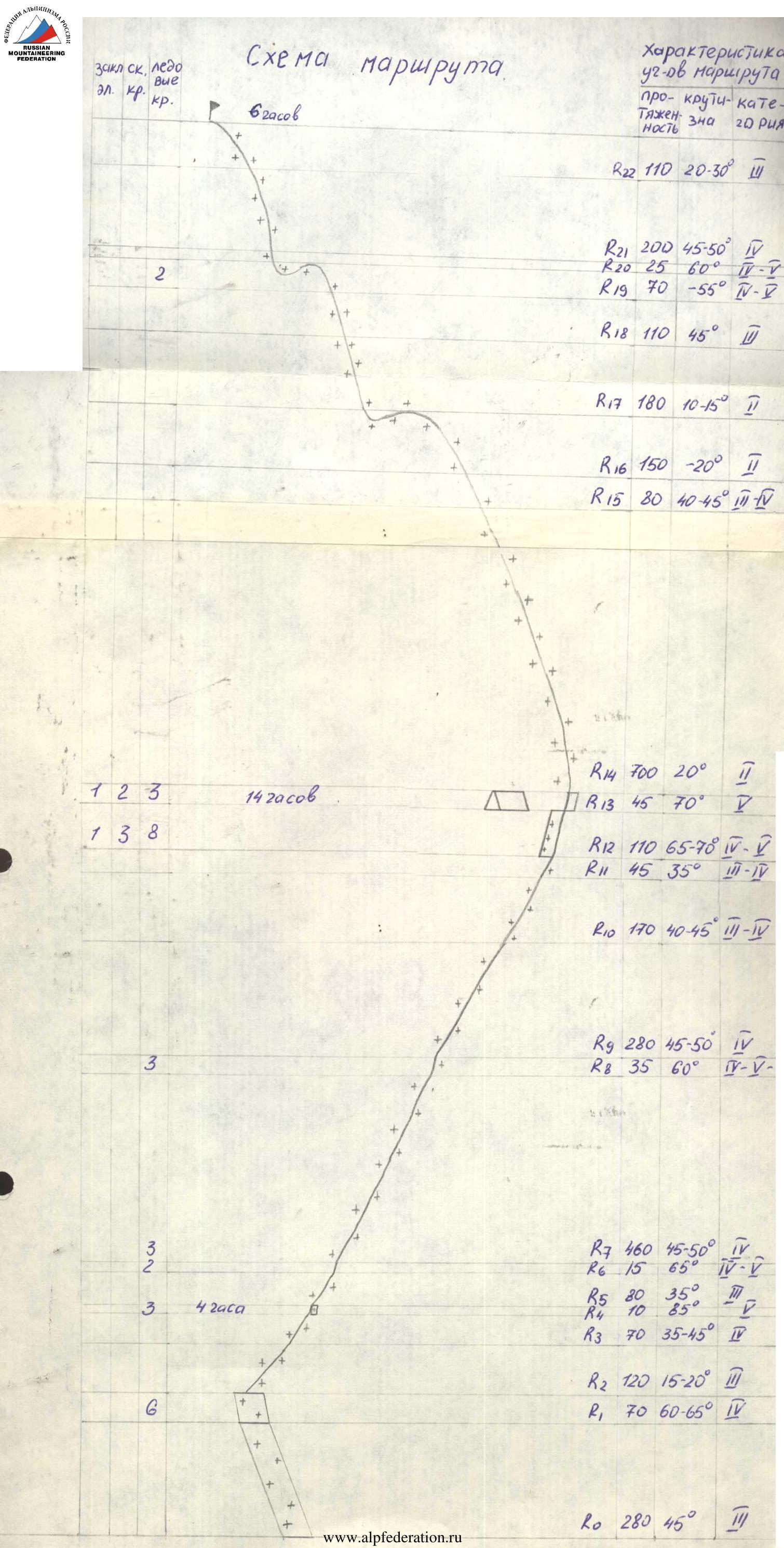
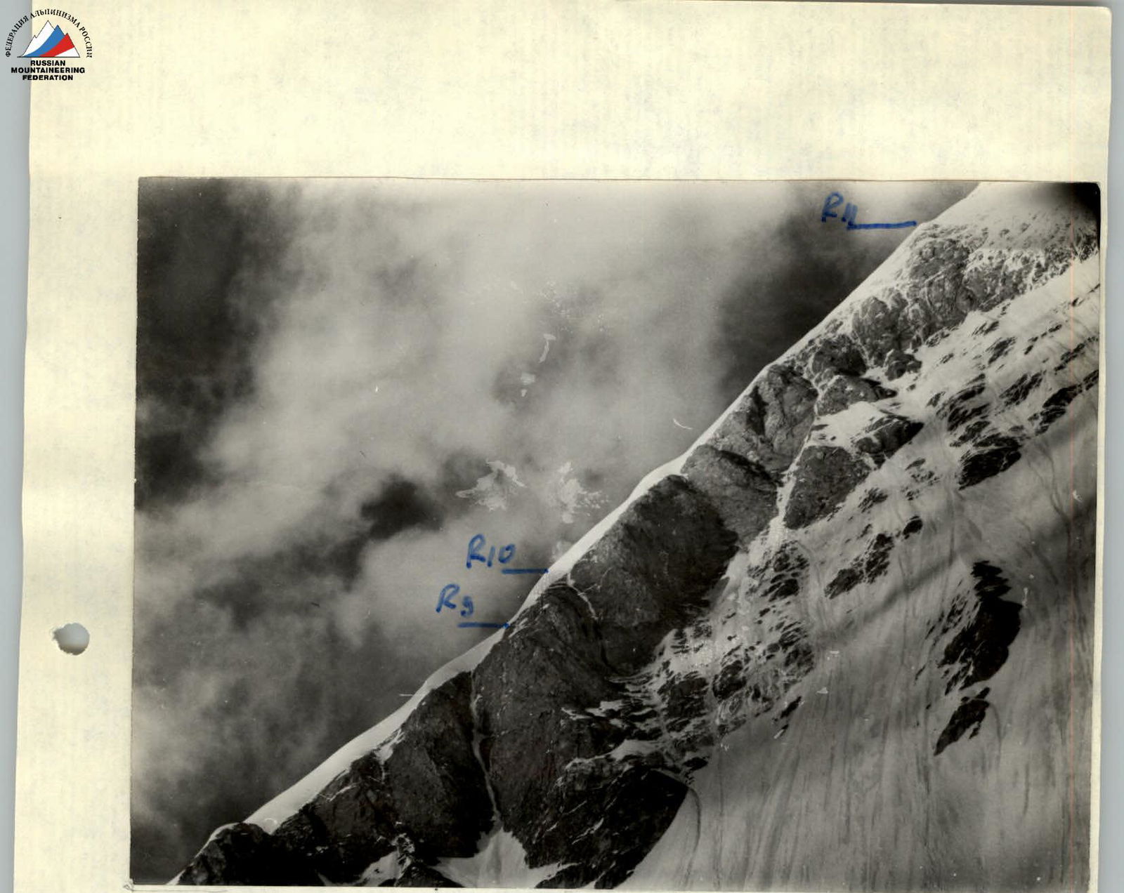 Photo #2 Southwest ridge sections R7-R11, photo taken from point #2 (cirque 4900 m).
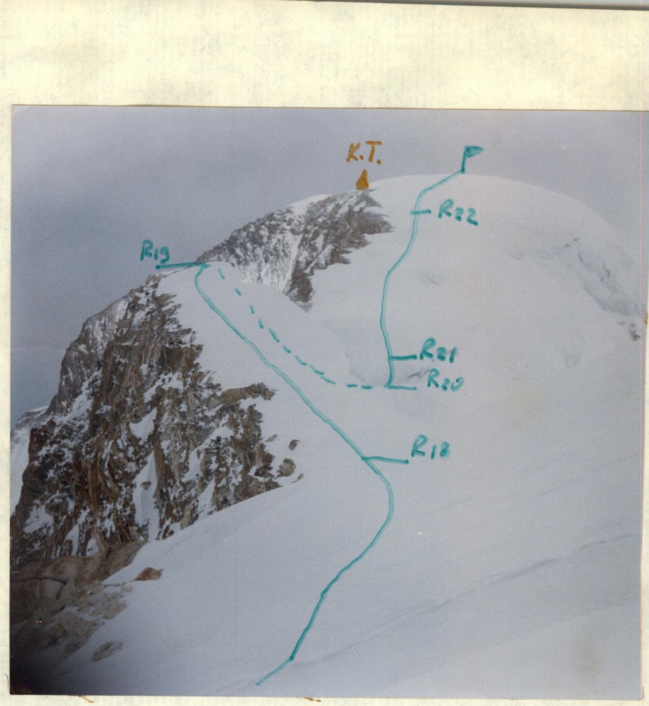 Photo #4 Summit Zapadny Shatyor. Photo taken on the route of the south ridge (section R17-R18), August 20, 1995.