
ASCENT DOCUMENT
-
Ascent class: high-altitude technical.
-
Ascent area, ridge: Central Tien Shan, Tengri Tag.
-
Peak, its height, ascent route:
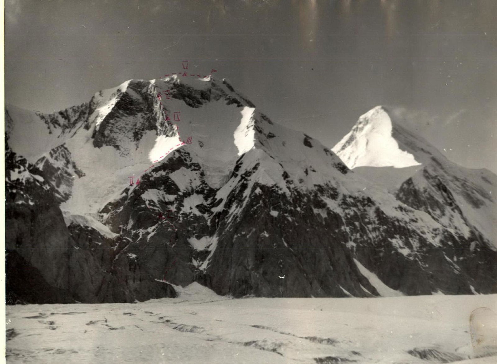
Peak Chapayeva, 6371, via the Western part of the South face.
-
Proposed difficulty category: 6B.
-
Route characteristics:
height difference – 2371 m, length of sections with 5–6 difficulty category – 2050 m, average slope – 55°.
-
Pitons hammered in:
| rock | ice | bolt | |
|---|---|---|---|
| for belay | 305 | 132 | 4 |
| for setup and org. | – | – | – |
-
Number of climbing hours: 55 h.
-
Number of nights and their characteristics:
6 nights, 3 good, 3 satisfactory.
-
Participants:
Zhura Boris Petrovich — Candidate Master of Sports, team captain
- Lovchev Eduard Mikhailovich — Candidate Master of Sports
- Ustinovich Vasily Vyacheslavovich — 1st sports category
- Otchik Valery Kuzmich — Candidate Master of Sports
- Solovey Oleg Matveevich — Candidate Master of Sports
- Karpenko Fedor Maksimovich — 1st sports category
-
Team coach:
Lozovsky Leonid Ivanovich — Master of Sports, 1st category instructor.
-
Date of departure on the route — July 26, 1980, date of return — August 2, 1980.
TABLE
main characteristics of the ascent route to Peak Chapayeva via the Western part of the South face (first ascent) Table I

| Date | Designation | Average slope | Length in meters | Terrain characteristics | Difficulty | Condition | Weather conditions | Rock | Ice | Bolt |
|---|---|---|---|---|---|---|---|---|---|---|
| July 26, 1980 | R0–R1 | 85 | 160 | inner corner, wall | 1 | monolith | good | 49 | – | 3 |
| R1–R2 | 35 | 40 | ledge | 4 | – | – | 3 | – | – | |
| R2–R3 | 40 | 120 | wall, ledge | 3 | destroyed | – | 2 | – | – | |
| R3–R4 | 65 | 160 | counterfort | 1 | – | snowfall | 29 | – | – | |
| R4–R5 | 50 | 140 | ledge, small wall | 1 | – | – | 25 | – | – | |
| July 27, 1980 | R5–R6 | 35 | 300 | ledge, small wall | 4 | monolith | good | 41 | – | – |
| R6–R7 | 70 | 80 | ledge, inner corner | 1 | – | – | 14 | – | – | |
| R7–R8 | 50 | 80 | ridge | 4 | destroyed | snowfall | 10 | – | – | |
| July 28, 1980 | R8–R9 | 45 | 80 | snow-ice ridge | 1 | good | – | – | 12 | – |
| R9–R10 | 30 | 80 | – | 4 | – | – | – | 9 | – | |
| R10–R11 | 50–60 | 560 | ice-snow ridge | 1 | cornices, | snowfall | – | 60 | – | |
| icefall | ||||||||||
| July 29, 1980 | R11–R12 | 20 | 300 | sports ridge | 3 | cornices | good | – | – | – |
| R12–R13 | 35–40 | 160 | snow-ice slab | 4 | – | – | – | 16 | – | |
| R13–R14 | 40 | 80 | rocks covered with snow and ice | 1 | – | – | 10 | 5 | – | |
| R14–R15 | 65–70 | 240 | the same | 1 | – | – | 53 | – | 1 | |
| July 30, 1980 | R15–R16 | 55–60 | 120 | snow-ice ridge | 1 | – | good | – | – | 15 |
| R16–R17 | 60 | 280 | snow-rock ridge | 1 | – | snowfall | 69 | – | – | |
| July 31, 1980 | R17–R18 | 45 | 150 | snow ridge | 1 | – | fog | – | – | – |
| R18–R19 | 25 | 200 | the same | 3 | cornices | fog, snowfall | – | – | – | |
| August 1, 1980 | R19–R20 | 20 | 80 | snow ridge | 3 | – | good | – | – | – |
| R20–R21 | 45 | 240 | ice-snow ridge | 4 | cornices | good | – | 15 | – |
Departure time: 8:00. Stop for the night at 20:00. Number of climbing hours – 12 h. Night spent in a semi-sitting position on a rock ledge, satisfactory.

Departure time: 10:00. Stop for the night at 18:00. Number of climbing hours – 8 h. Night spent on a ledge carved in the ice ridge, satisfactory.
Departure time: 10:00. Stop for the night at 19:00. Number of climbing hours – 9 h. Night spent on a snow cushion, good.
Departure time: 8:00. Rest stop – 12:00–13:00. Stop for the night at 19:00. Number of climbing hours – 10 h. Night spent on a cleared rock ledge, satisfactory.
Departure time: 10:00. Rest stop – 14:00–15:00. Stop for the night at 18:00. Number of climbing hours – 7 h. Night spent on a cleared rock-ice ledge, satisfactory.
Departure time: 10:00. Stop for the night at 15:00. Number of climbing hours – 5 h. Night spent on a snow ridge, good.
Departure time from the bivouac: 7:00. Time of reaching the summit: 11:00. Number of climbing hours – 4 h.
ROUTE DESCRIPTION
(Explanation for the table of main route characteristics) The beginning of the route — the lower part of a clearly visible inner corner — a “book”. From above, the inner corner is closed by an overhanging reddish rock. Up the inner corner for 40 m and then up its right side to exit onto the ridge to the right of the reddish overhanging rock. Climbing is very difficult. Bolt pitons were used for belay organization (section R0–R1).
Further movement:
- left-up 40 m,
- then right-up to a slightly visible inner corner with a stream flowing through it (sections R1–R3).
Up the inner corner for 160 m, then along the counterfort, partially covered with snow for 140 m — exit to the 1st night's bivouac (sections R3–R5). Further up through complex rocks to the beginning of a snow ridge going up from left to right. In front of the complex reddish rocks forming the rock ridge, a control cairn is built. Exit onto the snow ridge via steep crevices; climbing is difficult (sections R5–R8); second night's bivouac.
Keeping to the left slope of the snow-ice ridge, exit onto a large snow cushion. The ice-snow ridge (sections R8–R11) is a series of alternating sections:
- cornices,
- ice walls,
- crevices.
Cornices overhang to the right along the path. The upper part of the ridge is a horizontal snow cushion suitable for a good night's bivouac.
Along a gentle snow ridge for 300 m, transitioning into a snow-ice slab, exit left onto a rock ridge, which is partially covered with snow and ice and has a significant slope. When moving along it, one has to clear rocks from snow and ice. In the middle part (section R15–R16, 120 m) and in the upper part (section R17–R18, 45 m) the rock ridge is interrupted by snow-ice sections. Exit onto the main pre-summit ridge (sections R11–R18).
Further east along the main snow-ice ridge — exit to the summit (sections R18–R21). Descent from the summit to the north along the ridge with 5A complexity category to the saddle between Peak Chapayeva and Khan Tengri. Descent from the saddle to the south onto the South Ipyldyrak Glacier and arrival at the base camp.
Comments
Sign in to leave a comment