PASSPORT
- High-altitude technical climb category.
- Central Tian-Shan, Tengri-Tağ range, South Inylchek glacier.
- Khan-Tengri peak (6995 m) via the southwest wall.
- Proposed route: 6th category of difficulty, first ascent.
- Height difference: 2660 m; route length — 3448 m.
Length of sections with 5–6 category of difficulty — 1134 m. Average steepness of main sections 62° (4336–6130), including 95 m of 6th category at 87°.
- Pitons used:
| Rock pitons | Bolts | Nuts | Ice screws |
|---|---|---|---|
| 169 | 10 | 17 | 58 |
| 14 | 10 | 5 | 0 |
- Team's travel time: 123 hours and 15 days.
- Camps: 10 locations, 14 bivouacs; 1, 8, 9 on rocky platforms, the rest on platforms carved in the snow-ice ridge.
- Team leader: Vadim Sergeyevich Sviridenko, Master of Sports up to 6490 m.
Pyotr Ivanovich Staritskiy, Candidate for Master of Sports.
Team members:
- Igor Alexandrovich Orobey, Master of Sports.
- Mstislav Mstislavovich Gorbenko, Master of Sports.
- Vadim Gennadyevich Leontyev, Candidate for Master of Sports.
- Alexander Alexandrovich Serpak, Master of Sports.
- Vladimir Maevich Alperin, Candidate for Master of Sports.
- Alexander Vadimovich Kholoptsev, Candidate for Master of Sports. (up to 6490 m)
- Coach: Vadim Sergeyevich Sviridenko.
- Route entry: July 27, 1982. Summit — August 10. Return — August 12.
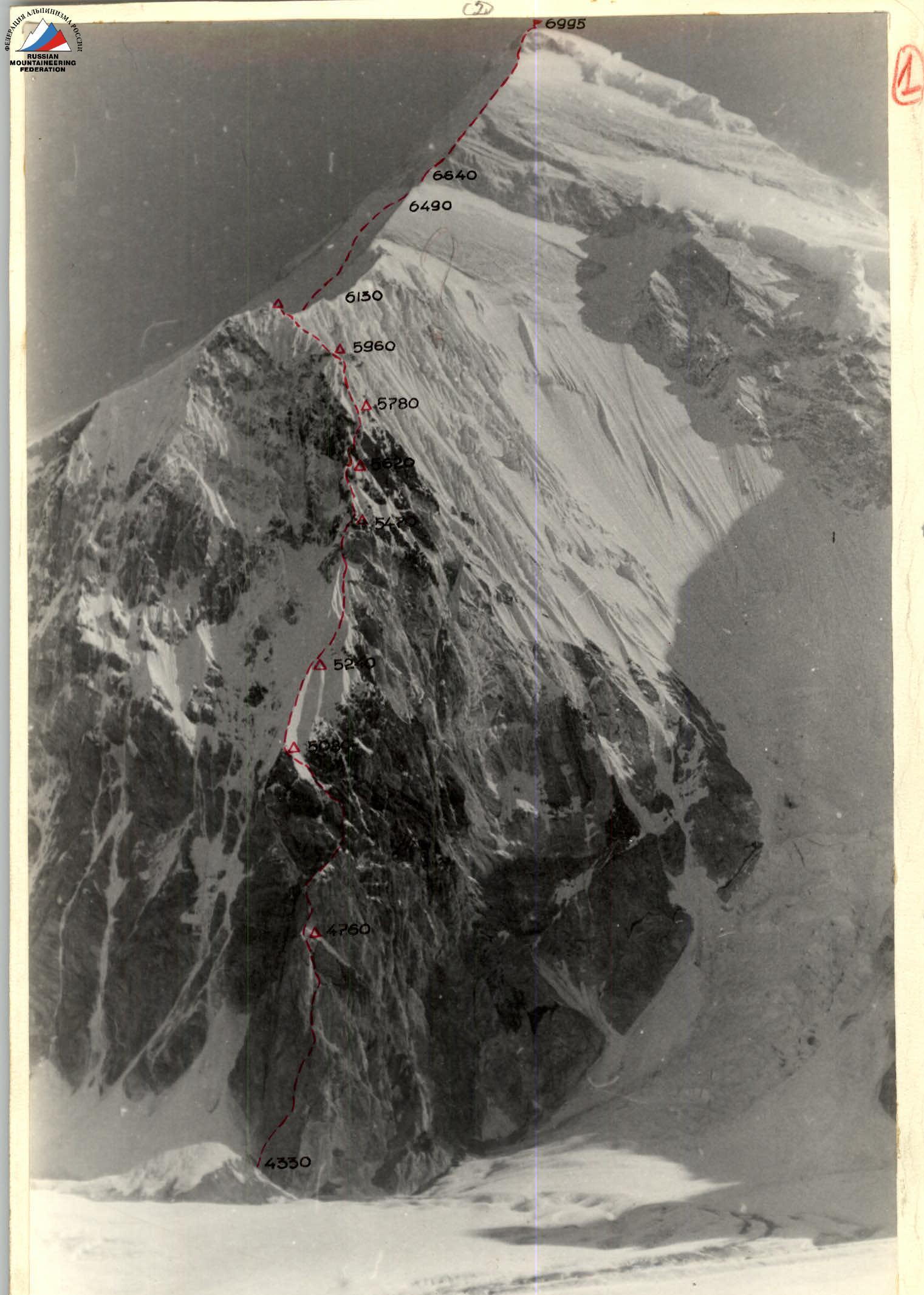
Photo 1. Overall photo of the summit. Taken from point No. 1 (4450 m), distance 5 km, July 18, 1982, 9:00, "Lubitel" camera.
Tactical actions of the team.
The tactical plan envisaged passing the "triangle" in six days and the "marble" ridge in two days. A two-day reserve for bad weather was planned, but the food supply and fuel reserve allowed for longer work.
During the ascent, several deviations from the planned route occurred due to objective reasons related to weather conditions:
- From July 30 to August 6, the team worked in prolonged bad weather (snowfall, wind, fog, cold), which limited their progress to 40–60 m of the route on some days.
- Passing the upper part of the "knife" and other snowy sections required digging trenches (sometimes up to 2 m deep) due to the great steepness and specific snow structure.
- The halt in movement along the snow-ice "knife" (section R2) on the second day of ascent was caused by increased avalanche danger.
Tactical decisions that allowed the team to avoid critical situations in extremely difficult ascent conditions include:
- Dividing the team into two groups of four with full autonomous support:
- food;
- fuel;
- stove;
- radio;
- tent;
- first-aid kit.
- Organizing an emergency "drop" of food and fuel at the "triangle" summit and scouting the descent route to the upper cirque of the Semenovsky glacier;
- Preliminary processing and rope-assisted passage of the entire "triangle";
- Regular rotation of rope teams and leaders (see section 9–II), and radio communication between the first rope team and the leader;
- Organizing "lying" bivouacs on snow and ice, removing the lower bivouac only after reaching the location for the next possible platform, maintaining a stable workday and moving upward in any weather;
- Using special ice screws:
- shortened (40 mm) for ice formations;
- extended (400 mm) for thick firn cover;
- avalanche shovels for insurance on snow;
- non-standard (trench) passage of snowy ridges.
On section R61–R63, there were four instances of people hanging on the rope after cornice collapses. This happened to:
- Staritskiy;
- Kholoptsev;
- Serpak;
- Leontyev.
No injuries or frostbite occurred. Regular radio contact was maintained with observers.
Photo 2. Profile of the wall on the right. Taken from point No. 3 (4400 m), distance 4.5 km, July 28, 1982, 13:00, I-50 lens. Bivouac locations. "Avangard" team route, 1982.
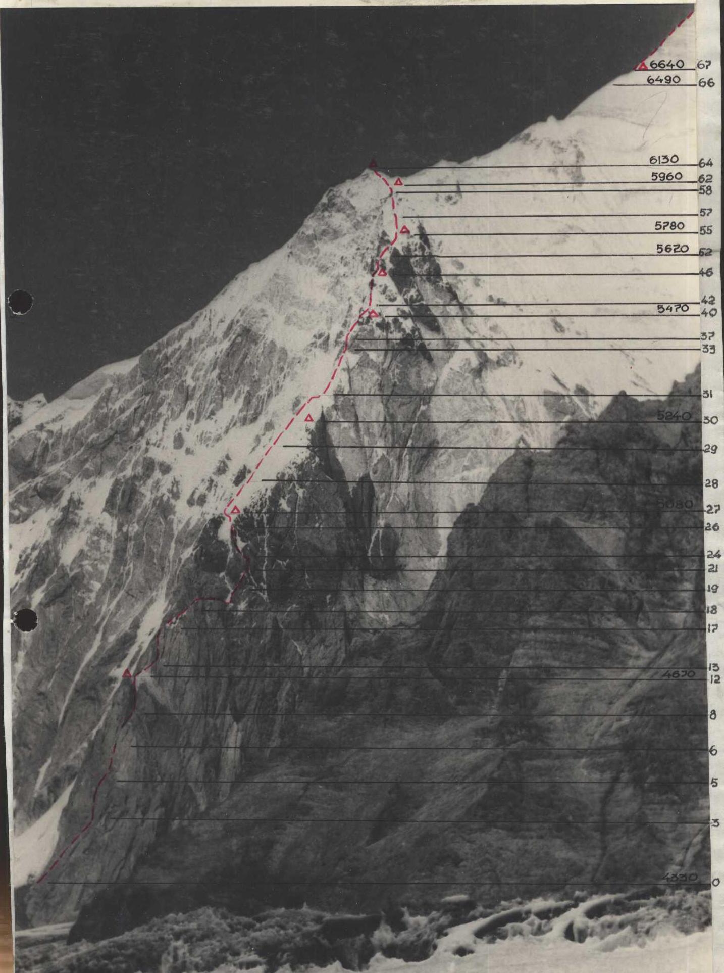
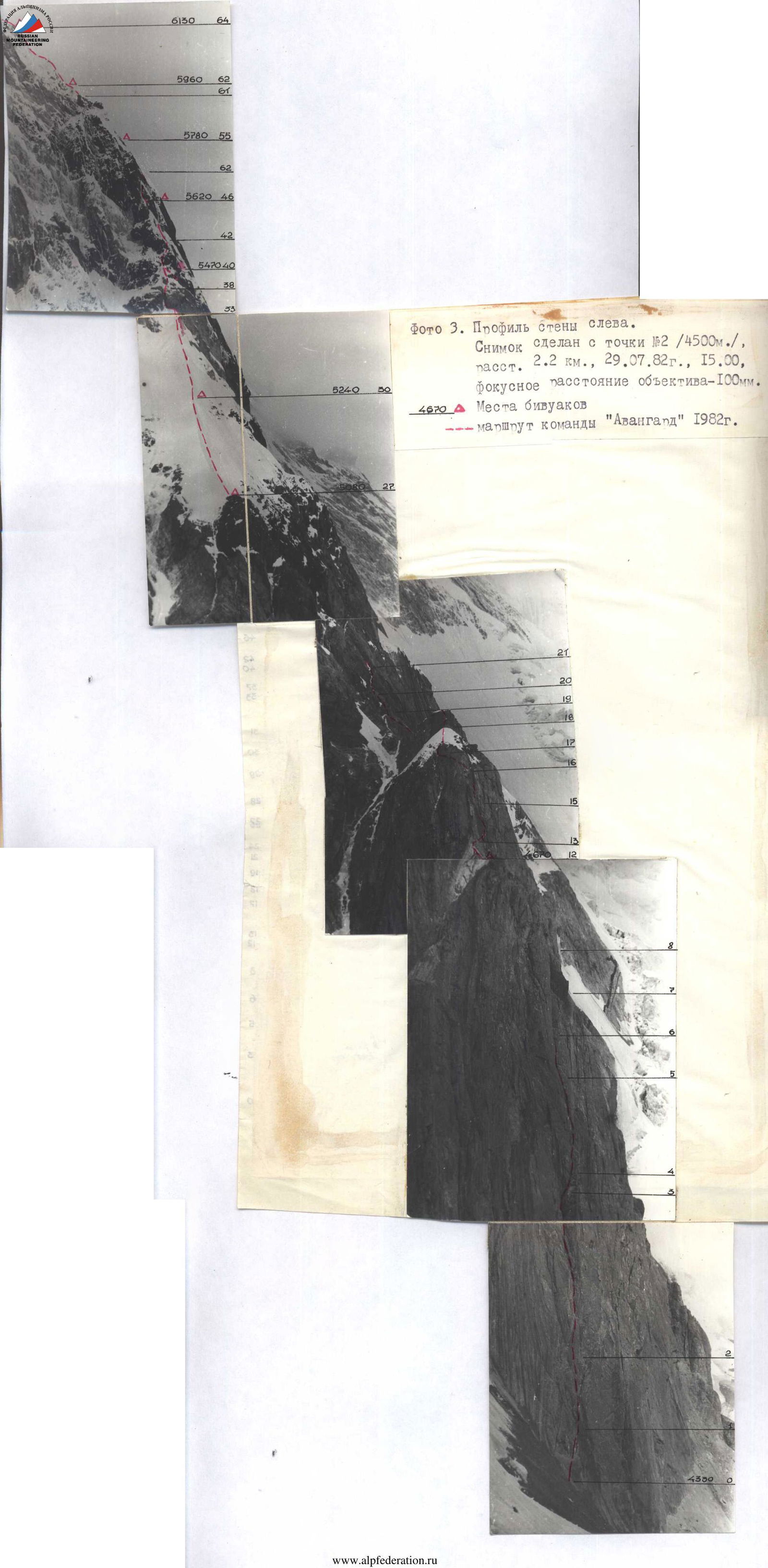
Photo 3. Profile of the wall on the left. Taken from point No. 2 (4500 m), distance 2.2 km, July 29, 1982, 15:00, 100 mm lens. Bivouac locations on the "Avangard" team route, 1982.
ROUTE SCHEME IN SYMBOLS FOR KHAN-TENGRI PEAK VIA THE SOUTHWEST WALL, SCALE 1:2000; 1:5000 (sheet 8-G)
| Rock pitons | Ice pitons | Bolt pitons | Nuts | Section description |
|---|---|---|---|---|
| 1 | III 40 m 45° | |||
| 2 | IV 15 m 70° | |||
| 3 | V 30 m 70° | |||
| 7/3 | 3/2 | V 20 m 80° | ||
| 5 | 1 | IV 40 m 60° | ||
| 3 | II 20 m 30° | |||
| 48 pitons – 19 hours | ||||
| 2 | V 20 m 90° | |||
| 1/1 | VI 5 m 95° | |||
| 5/2 | 2 | V 30 m 90° | ||
| 3/1 | II 20 m 40° | |||
| 10/10 | VI 15 m 80° | |||
| 4 | ШЛ VI 15 m 90° | |||
| 6 | V 25 m 80° | |||
| 2 | IV 40 m 75° | |||
| 5 | 2 | V 8 m 90° | ||
| 3 | 1 | V 90 m 80° | ||
| 2 | IV 40 m 70° | |||
| IV 40 m 60° |
| Rock pitons | Ice pitons | Bolt pitons | Nuts | Section description |
|---|---|---|---|---|
| IV 120 m 40° | ||||
| 6 | ||||
| 54 pitons – 13 hours | ||||
| 2 | III 60 m 35° | |||
| V 40 m 60° | ||||
| 4 | IV 80 m 65° | |||
| 5 | IV 40 m 65° | |||
| 2 | 1 | IV 20 m 70° | ||
| 2 | V 20 m 85° | |||
| 3/1 | 1 | 2 | III 20 m 50° | |
| 4 | IV 40 m 70° | |||
| 3 | III 60 m 25° | |||
| 3 | V 20 m 80° |
| Rock pitons | Ice pitons | Bolt pitons | Nuts | Section description |
|---|---|---|---|---|
| 3 | 1 | V 10 m 80° | ||
| 1 | V 10 m 50° | |||
| 1 | 28 pitons – 14 hours | |||
| 2 | IV 20 m 45° | |||
| 5/4 | 4/2 | V 40 m 90° | ||
| 8 | IV 30 m 60° | |||
| 3 | IV 30 m 50° | |||
| 4/4 | V 30 m 90° | |||
| 2 | 33 pitons – 15 hours | |||
| IV 20 m 55° | ||||
| 3 | IV 40 m 60° | |||
| 3/4 | IV 15 m 60° | |||
| 2 | IV 15 m 70° | |||
| 5/2 | V 15 m 80° | |||
| 3/1 | VI 10 m 90° | |||
| 2 | V 10 m 80° | |||
| 1 | 1 | V 10 m 70° | ||
| 4 | V 40 m 70° | |||
| 3 | V 40 m 60° | |||
| 6 | IV 80 m 55° | |||
| 13 pitons – 7 hours | ||||
| 5 | IV 70 m 45° |
| Rock pitons | Ice pitons | Bolt pitons | Nuts | Section description |
|---|---|---|---|---|
| V 160 m 55° | ||||
| 8 | ||||
| 23 pitons – 13 hours | ||||
| 2 | 1 | V 35 m 60° | ||
| 2 | VI 10 m 90° | |||
| III 15 m 40° | ||||
| V 10 m 80° | ||||
| 3 | 4 | IV 100 m 55° | ||
| 8 | IV 20 m 60° | |||
| 3 | 23 pitons – 15 hours | |||
| V 30 m 55° | ||||
| 4 | V 50 m 55° | |||
| 2 | IV 20 m 60° | |||
| 3 | VI 30 m 85° | |||
| IV 20 m 60° | ||||
| 1 | V 15 m 90° | |||
| IV 15 m 60° | ||||
| VI 10 m 80° |
SCALE 1:5000, KHAN-TENGRI 6995
| Rock pitons | Ice pitons | Bolt pitons | Nuts | Section description |
|---|---|---|---|---|
| 254 pitons – 123 hours | ||||
| 10 pitons – 7 hours | ||||
| 10 | IV 500 m 45° | |||
| 10 | 10 pitons – 3 hours | |||
| V 200 m 50° | ||||
| 4 hours – 0 pitons | ||||
| III 540 m 40° | ||||
| 2 | 2 | 13 hours – 12 pitons | ||
| VI 60 m 10° | ||||
| V 40 m 60° |
Route description by sections.
July 27. The team passes the processed section. Leontyev leads, the others follow at 20-minute intervals. Movement is with clamps, and on complex sections, "American extraction" of backpacks is used. At 16:00, the Leontyev–Staritskiy pair reaches the planned bivouac site and begins processing the next section — a chimney in the wall continuing the bastion. Difficult climbing inside the chimney involves using ladders, and ice is encountered. Further along the internal corner of the widening chimney upward — left, with an exit to the wall. After processing 110 m, the pair returns to the bivouac at 20:00. Snowfall begins. (Section R0–R16).
July 28. At 9:00, the Gorbenko–Kholoptsev pair passes the processed section, then the upper, very destroyed part of the wall closing the bastion. Next is a complex exit to the snow-ice "knife." Constant spontaneous avalanches fall from the "knife" ridge along the couloir separating the rocky ridge from the "knife." (Section R12–R27).
July 29. At 9:00, the Orobey–Staritskiy pair departs. On the "knife," the snow does not hold its shape and flows. Only by breaking through a trench 1–1.5 m deep and reaching the ice can the team use ice screws and work in crampons. The steepness of the "knife," not exceeding 35° in the lower part, gradually increases, reaching 70° on the last rope length of the "knife." (Section R27–R31).
July 30. At 10:00, Gorbenko–Kholoptsev pass the processed section. Gorbenko then crosses a snow-ice gully and, via complex ice relief, reaches a sharp snowy ridge leading to rocks. After passing rocks covered in ice and snow — into an internal corner with a cornice, then along the right wall of the internal corner, which is a smooth slab, followed by a transition into the internal corner filled with snow from top to bottom, Gorbenko exits from under the cornice onto a small ledge. Not reaching the possible bivouac site, the pair descends to the previous bivouac. Snowfall continues, dense cloud cover. (Section R30–R37).
July 31. At 9:00, the Staritskiy–Orobey pair, having passed the section processed the day before, exits under a small rocky wall transitioning into a steep snowy ridge along snow-covered rocks. Moving right of the ridge along a rocky gully filled with snow and ice, the pair reaches a red wall leading to the main rocky ridge of the counterfort.
Under the wall, on a snowy ridge, a bivouac is established on platforms carved into the ice. The Staritskiy–Orobey pair continues processing the red wall along the internal corner. Blocky rock structure, ice formations, and loose rocks are encountered. 30 m are processed. Platform preparation takes 3.5 hours. (Section R30–R42).
August 1. At 10:00, the Serpak–Alperin pair begins processing the further route. Movement is along the ridge on slabs with a 50° steepness, covered in snow. The pair exits onto the right side of the ridge, then along ice-covered and snowy rocks with a 60° steepness — exiting under a wall consisting of large smoothed blocks. In the afternoon, they are replaced by the Staritskiy–Orobey pair. A 40-meter section of an отвесной wall leads to a narrow snowy ridge. Descent to the previous bivouac. (Section R40–R45).
August 2. Departure at 8:00. After passing the processed section, Kholoptsev–Gorbenko move along a narrow snowy ridge and exit to a wide — in its lower part — snowy couloir going left-upward. Movement is along rocks on the left part of the couloir. Snow and ice formations are encountered. Then along a snowy ridge, through a trench up to the chest — to the base of rocks covered in snow. Then a traverse along a vertical wall to the right (30 m), onto a narrow shelf. Gorbenko then passes along a snowy slope with a 60–70° steepness and, securing the rope, descends to a new bivouac. (Section R46). The platform is only for one tent; the second remains at the previous bivouac. Temperature drops, snow, strong wind. (Section R40–R49).
August 3. At 9:00, Gorbenko–Leontyev depart along processed ropes. Further — 30 m upward along rocks protruding from under the snow. Under a thin layer of snow — ice formations. Then the route goes right along ice-covered smooth slabs (20 m). Dry avalanches periodically fall from above, covering the leading climber up to the chest. Continuing the route to the right, they cross a narrow gully, then exit upward along a snowy slope onto a snowy ridge. For insurance, the snow on the ridge had to be dug out to 1.5 m. Gorbenko leads, then Leontyev takes the lead. Movement is along a steep snowy slope, through a deep trench. Snow is deep and loose. Insurance is provided using ice screws and an ice axe. Upon reaching a suitable location for a tent, Leontyev takes Kholoptsev and descends to the previous bivouac. One tent is set up at the new location. Very cold, fog, snow, wind. (Section R46–R55).
August 4. At 10:00, the Kholoptsev–Alperin pair departs for further processing. Wind, cold, drifting snow. Work is similar to the previous day. Then Leontyev and Staritskiy take the lead. Leontyev exits onto the left side of a wide snow-ice couloir. Weather deteriorates sharply. After passing 50 m, the pair descends to the bivouac. The bivouac is satisfactory, but drying is not possible. (Section R55–R57/R58).
August 5. At 8:30, Gorbenko–Serpak, having passed 60 m along a snowy slope from the processed part of the route, exit onto a snowy ridge leading to a small rocky wall (10 m, 80°). Further, the ridge leads to a wall without holds (10 m, 90°). Then a snowy "knife" 35 m long, with an average steepness of 60°. Very difficult section. Snow is loose. Further, the ridge slightly flattens, allowing for tent setup. Weather is bad, visibility 25–30 m. (Section R55–R62).
August 6. At 9:00, Serpak–Gorbenko begin moving in deep, steep snow, then Gorbenko passes 60 m of a complex snow-ice wall (70°). Insurance: ice axe, ice screws. Leontyev, replacing Serpak, continues along a sharp snowy ridge with snow cornices. Unilateral cornices are avoided along ice slopes with up to 80° steepness. On some sections, they are forced to exit onto cornices, cut a trench in the cornice, and cross the slope under the cornice. Insurance and rope securing — through ice axes and long ice screws. Staritskiy replaces Gorbenko. Very cold. Not reaching a rope length to the "triangle" summit, the pair descends to the tents. (Section R62–R63).
August 7. At 9:00, Staritskiy–Orobey depart upward, traversing a snowy slope under rocks, then along an ice slope, exiting onto rocks at the "triangle" summit. By 18:00, the entire team reaches the "triangle." Snow and hurricane-force wind. Setting up tents is challenging. (Section R62–R64).
August 8. The team departs onto the route at 13:00. Pairs Kholoptsev–Gorbenko and Serpak–Alperin, alternating, lay the path along a snowy slope left of the marble ridge. By evening, snow starts, and the wind strengthens, with drifting snow. After 600 m, a bivouac is established in a snowy niche at the junction of rocks and snow. Snowfall continues throughout the night. Tents are continuously covered in snow. (Section R64–R66).
August 9. In the morning, Kholoptsev experiences a radiculitis attack. After first aid, a decision is made to urgently descend with the group (Sviridenko, Serpak, Alperin, Kholoptsev). Staritskiy becomes the team leader. The further route involves exiting onto the ridge along slabs. Insurance is through ledges. Then along the ridge 200 m, with a 50° steepness — to a location suitable for a bivouac. Wind, snow, visibility 20 m throughout the day. Overnight on a rocky platform. (Section R66–R67).
August 10. Departure at 8:00. The bivouac is not dismantled. Gorbenko–Orobey lead. Movement is along the marble ridge toward the summit. Ridge steepness ranges from 40° to 50°. Loose rocks, partially covered in snow. Movement is mostly simultaneous. (Section R67–R68).
At 16:00, the team reaches the summit. Weather is clear, windy, cold. At 16:30, descent begins along the ascent route to the bivouac on the ridge. (Section R68–R67). The further descent route follows the ascent path to the "triangle" summit, then to the Semenovsky glacier, and further to the assault camp.
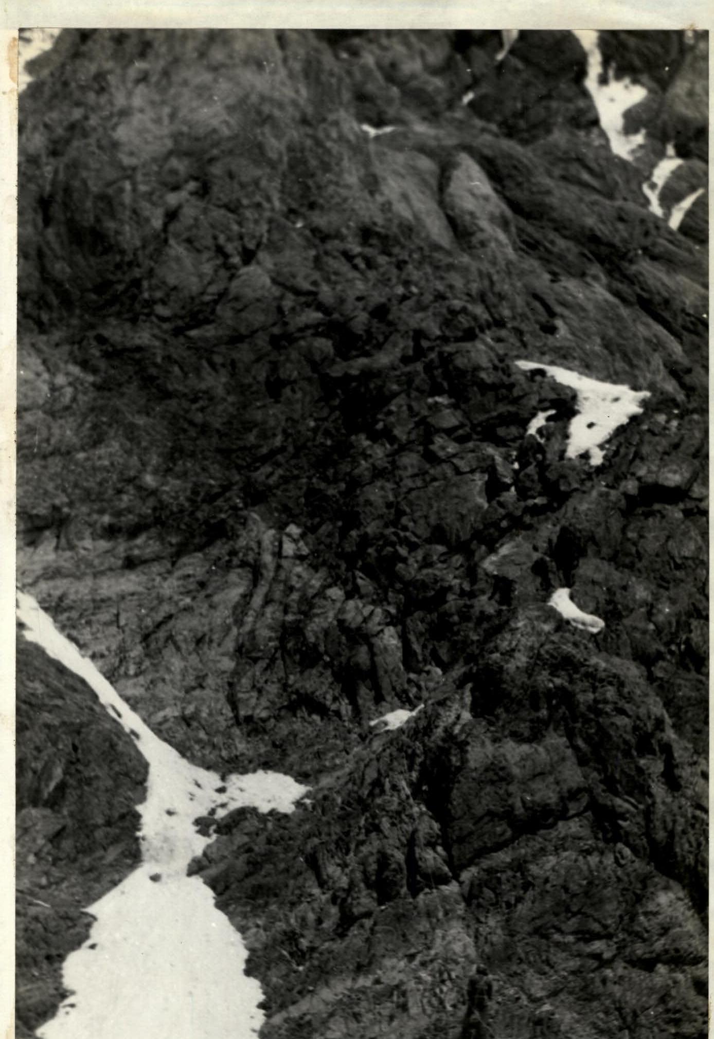
Photo 6. Exit onto the wall from the ridge, section R20–R21. July 28, 1982, 14:00, "Lubitel" camera, from the ridge (Section R19–R20).
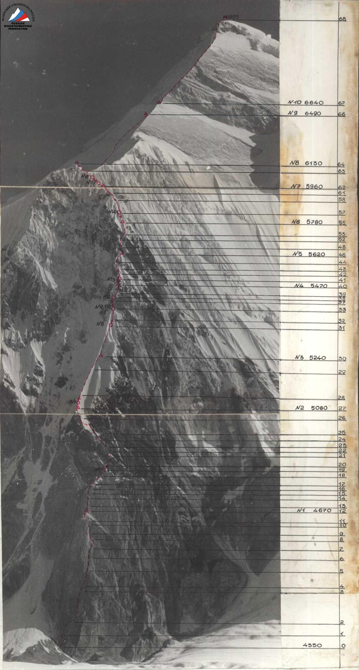
Photo 5. Technical photograph of the route:
- Taken from point No. 1 (4450 m)
- Distance: 5 km
- Date: July 18, 1982, 9:00
- Lens focal length: 100 mm
- Shooting points:
- Bivouac locations: Δ 5240, "Avangard" team route, 1982.
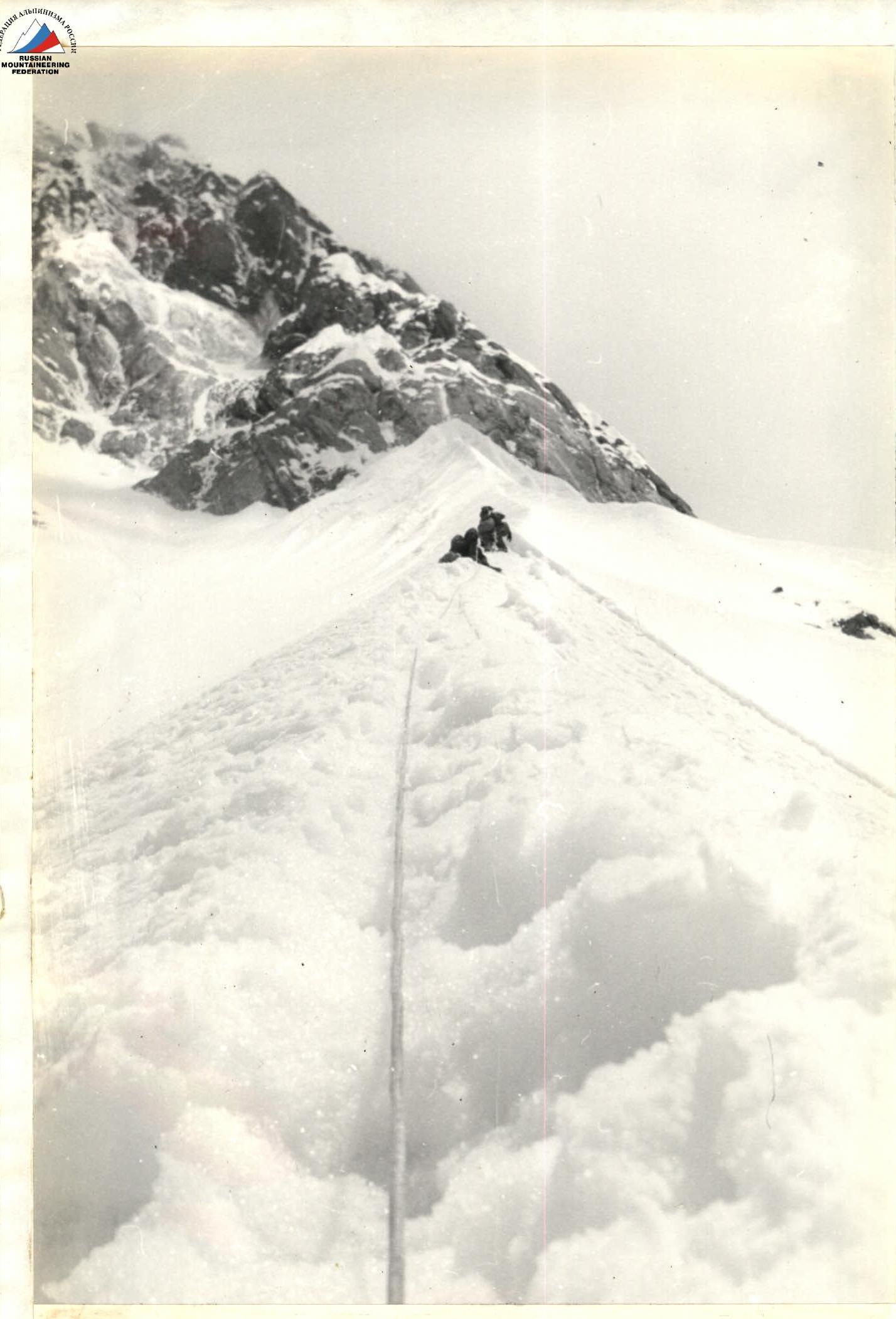
Photo 7. Beginning of the snow-ice "knife," section R27–R29. July 29, 1982, 12:00, "Lubitel" camera, from the bivouac (Section R27).
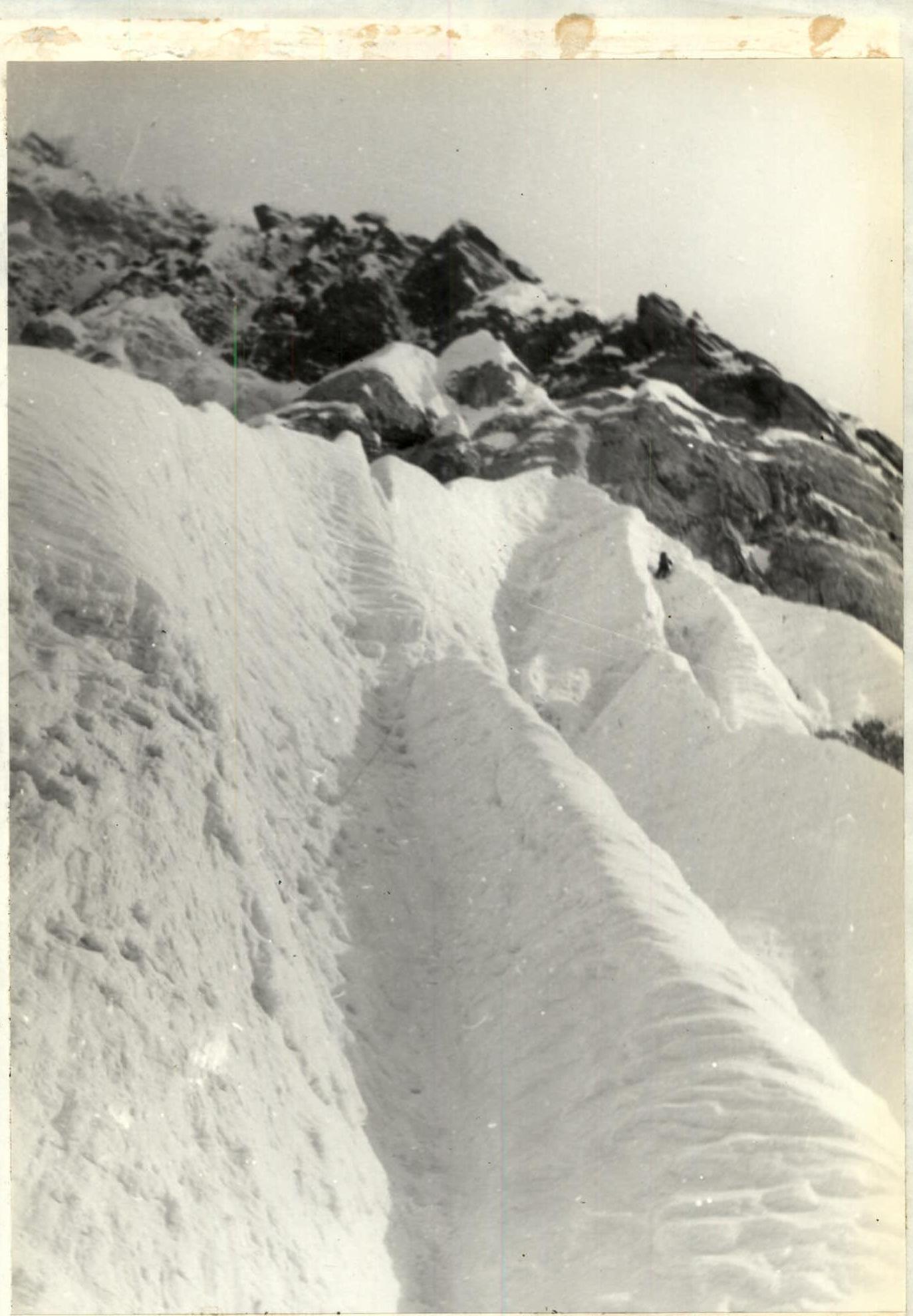
Photo 8. Passing the snow-ice "knife" in the upper part, section R31–R33. July 30, 1982, 11:00, "Lubitel" camera, from section R31.
Photo 9. Exit from the snow-ice "knife" under the wall, section R33–R34. July 30, 1982, 12:00, "Lubitel" camera, from the ridge (Section R33–R34).