Passport
-
Category of First Ascent
-
Tian-Shan, South Inylchek
-
Peak Khan-Tengri via the center of the East Face
-
Proposed — 5B category of complexity, first ascent
-
Height difference — 2000 m, length — 2950 m
- Length of sections with 5–6 category of complexity — 2905 m
- Average steepness of the main part of the route 48° (5020–6700)
- including 6 category of complexity: 85° (5850–5900); 55° (6350–6400); 70° (6610–6650)
-
Pitons driven:
- Rock: 14
- Bolt: 0
- Nuts: 6
- Ice: 273
- Rock: 3
- Bolt: 0
- Nuts: 2
- Ice: 0
-
Team's total climbing hours: 61, days: 7
-
Bivouacs R1–R6 — platforms carved and shaped on the snow-ice slope.
-
Team Leader: Shustrov Nikolay Borisovich, Master of Sports
- Team Members: Balyberdin Vladimir Sergeyevich, Master of Sports of International Class
- Shustrov Aleksey Borisovich, Candidate for Master of Sports
- Simonov Valeriy Pavlovich, Candidate for Master of Sports
- Petrikov Vladimir Dmitriyevich, Candidate for Master of Sports
- Kashurskiy Vladimir Anatolyevich, Candidate for Master of Sports
-
Coach: Razumov Yuriy Mikhaylovich, Master of Sports
-
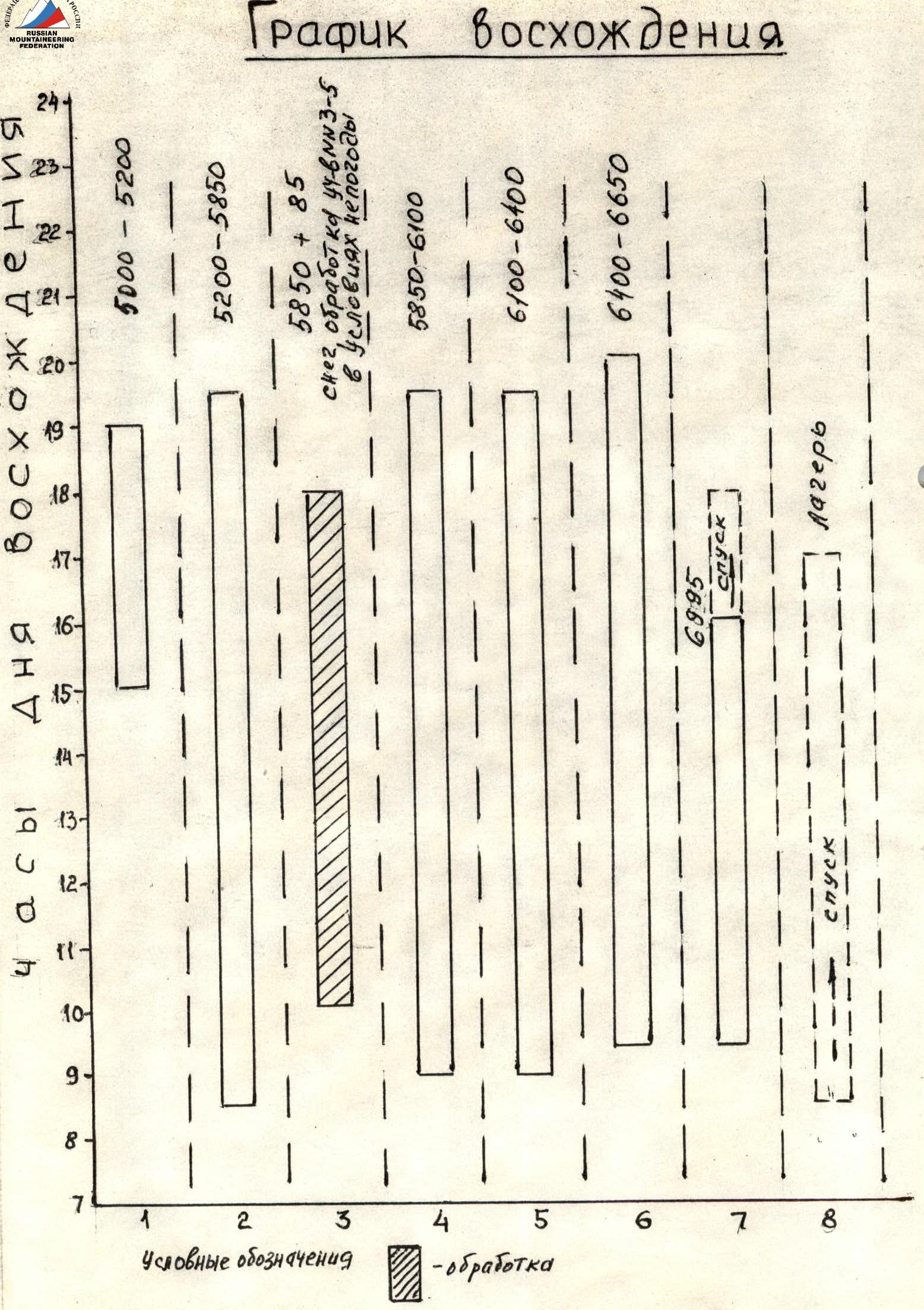
Departure to the route: August 1, 1987
- Summit — August 7, 1987
- Return — August 8, 1987
-
LenGorsportkomitet.
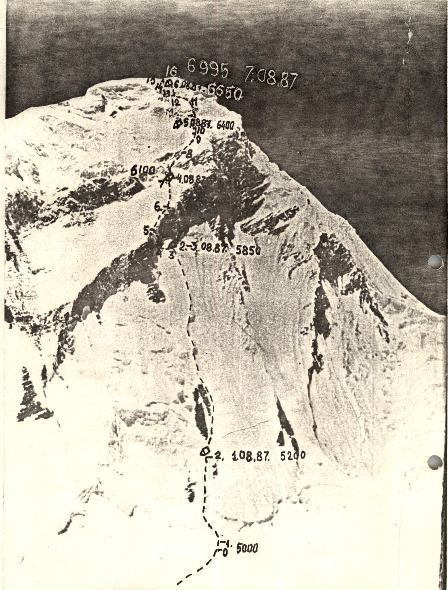
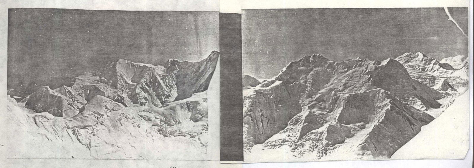
General photo of the summit, August 1, 1987, 12:22. Lens I-50. 5 km.
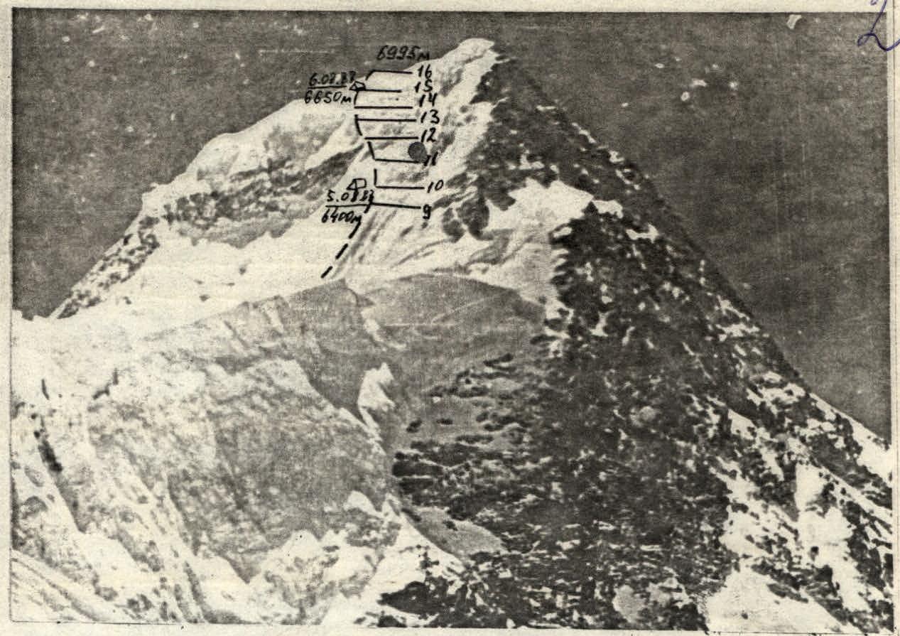
Profile of the upper part of the route. View of Khan-Tengri from Kuzmin's col. ≈6000 m. Camera "Agat". (Photograph obtained from the Odessa city team, 1987)
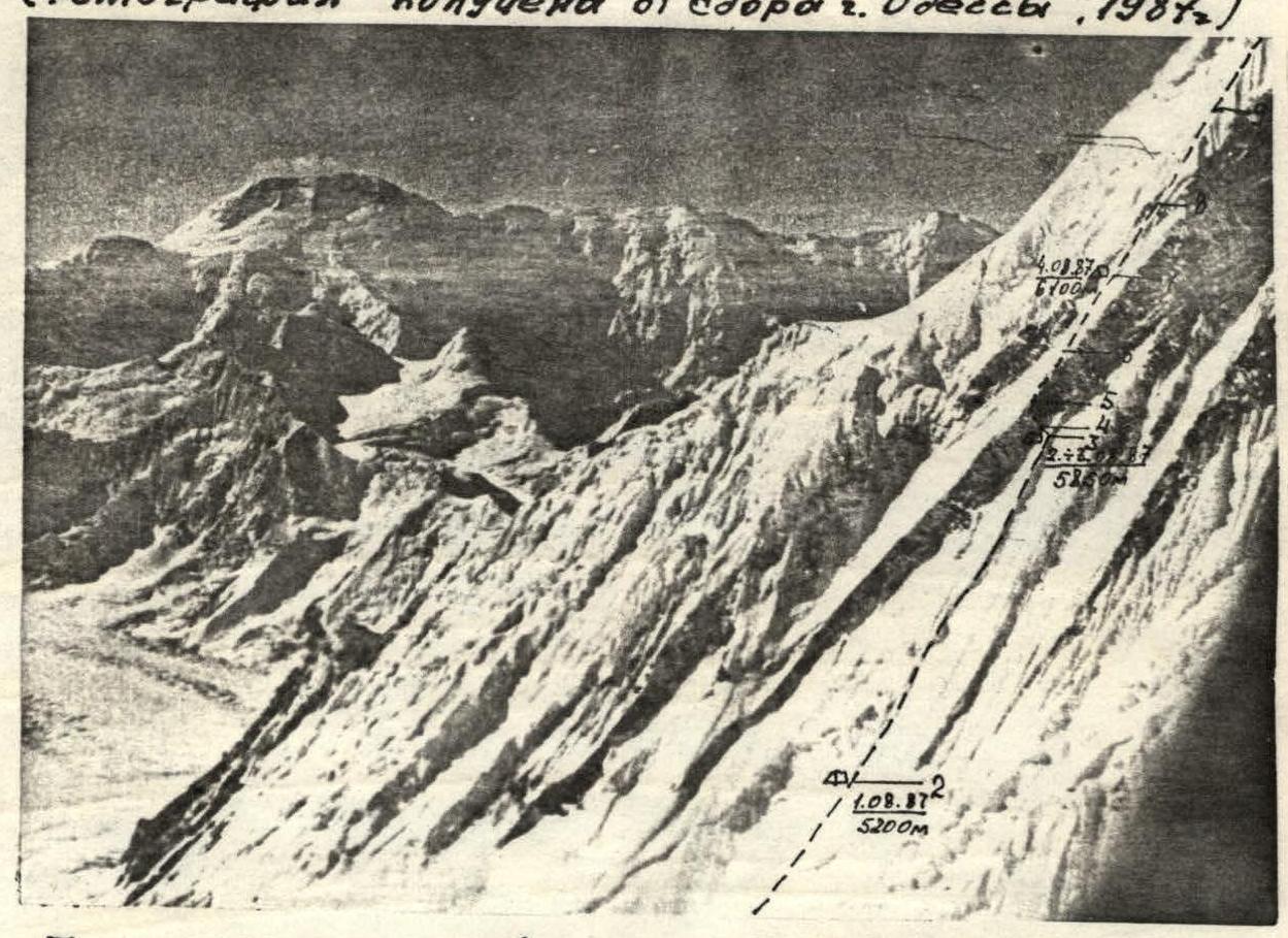
Profile of the lower part of the route. Taken from a helicopter on August 6, 1986.
Profile of the wall on the right.

Profile of the wall on the left. July 31, 1987, 16:00. Lens I-50. 8 km. --- Team's route ...... Team's route of Uz.SSR 1975 via the SSE ridge with exit to the col. via the key part of the East face (see appendix)
Preparation for the Ascent
The team began studying the area using photographs and slides, as well as the report of the Uzbek SSR team. Physical training of team members included cross-country training, ski racing with multiple participation in competitions. During technical training, winter outings to iced rocks in Vyborg and ice training in the ascent area were organized. Training camps were held in Yarydag and acclimatization under Peak Lenin.
During the preparation period, a special tent for high-altitude wall ascents was designed and manufactured.
The team's main requirements for the route were its safety and logic. Therefore, a route was chosen in the center of the East face via ice-snow couloirs. In the right and left parts of the wall, we observed a considerable number of rockfalls; our route justified our hopes in terms of safety and technical complexity.
The approach to the route through the Razorvaniy icefall presented certain difficulties. During an overflight by helicopter, a passage in the center was visible. However, a reconnaissance sortie showed that this option was incorrect.
On the second attempt, a passage was found to the right, under the slopes of Peak Nater, leading to a flat plateau under the East face of Khan-Tengri.
- Passage to the right under the slopes of Peak Nater
- Leads to a flat plateau under the East face of Khan-Tengri
- Approach from the base camp takes 1.5 days
Radio communication was carried out using a "Kaktus" radio station directly with the base camp.
Sections of the photopanorama from bivouac R5, August 6, 1987, 9:00, "Industar-50" (I-50), f=50 mm, 10 km, H=6400 m.
Ascent Schedule
Tactical Actions of the Team
Throughout the technically complex part of the route from the bergschrund to the summit cap, movement was carried out using fixed ropes. The first climber moved on a double rope, securing the ropes, while the others climbed up the fixed rope with top or bottom belay. Belay stations were organized using two or three pitons or nuts.
By evening, the weather usually deteriorated. On the third day of the ascent, bad weather caught up with us before the key section of the first rock belt. Snowfall, wind, and snow flows cascading down the wall as avalanches greatly complicated the work. Therefore, four team members stayed in the tent, while a pair went out to process the rock belt. This was how the reserve day for bad weather was used.
The remaining bivouacs were organized according to the tactical plan.
There are practically no convenient ledges or snow accumulations on the route; the snow is loose, but with the help of a karimat, we managed to shape a platform for the tent in 1.5–2 hours. All work on setting up a bivouac was carried out with rope belay, and the tent was also secured to pitons; at night, participants slept while attached to the rope with self-arrest.
The use of an autoclave for cooking, and the use of freeze-dried products allowed for quick preparation of a full-fledged meal.
Good team preparation, reliable technical support, and competent tactics allowed the team to complete the route in good style without any mishaps or injuries.
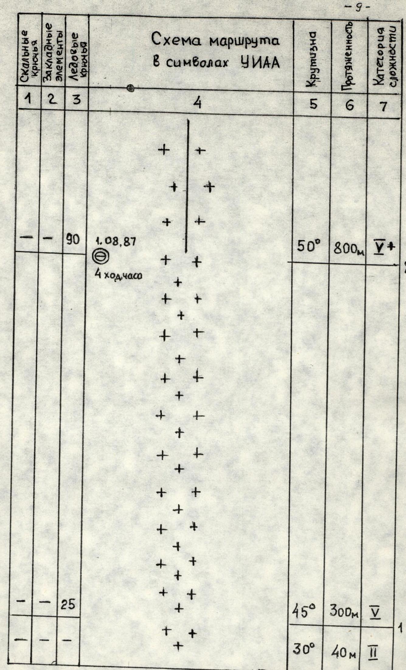
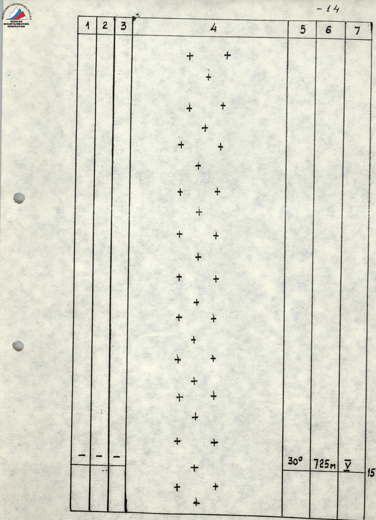
Route Diagram by Sections
| Section # | Rock Pitons | Nuts | Ice Pitons | Section Description | Steepness | Length | Category of Complexity |
|---|---|---|---|---|---|---|---|
| R2 | August 1, 1987, 4 climbing hours | 50° | 800 m | 5 | |||
| R6 | 30 | 50° | 250 m | 5 | |||
| R5 | 2 | 1 | 13 | 8 climbing hours | 30° | 120 m | 5 |
| R4 | 8 | 5 | 5 | 4 control cairns | 85° | 50 m | 6 |
| R3 | 3 | August 2–3, 1987, 11 climbing hours | 50° | 35 m | 5 | ||
| R9 | 8 | 55° | 50 m | 6 | |||
| R8 | 25 | 45° | 200 m | 5 | |||
| R7 | 2 | 10 | August 4, 1987, 10.5 climbing hours | 40° | 150 m | 5 | |
| R14 | 12 | August 6, 1987, 10.5 climbing hours | 50° | 90 m | 5 | ||
| R13 | 6 | 70° | 40 m | 6 | |||
| R12 | 10 | 50° | 80 m | 5 | |||
| R11 | 16 | 30° | 150 m | 5 | |||
| R10 | 20 | August 5, 1987, 10.5 climbing hours | 30° | 200 m | 5 | ||
| R15 | 30° | 725 m | 5 |
Total pitons driven: rock 14, bolt 3, nuts 6, ice 273. Total climbing hours: 61. Summit 6995 m reached on August 7, 1987.
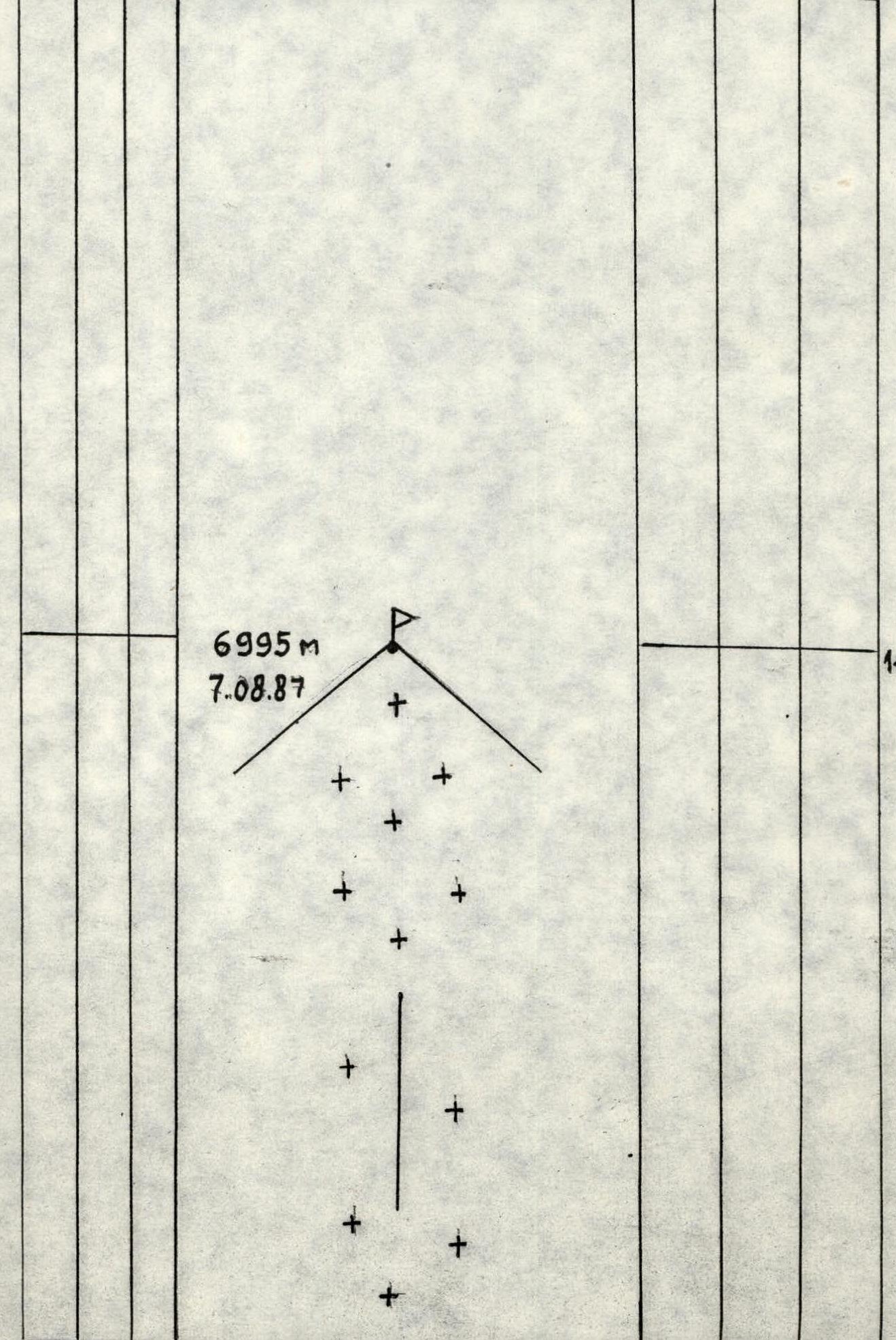
Route Description by Sections
R0–R1: The route starts below the rock outcrops in the lower part of the bergschrund. Approach to the bergschrund via a snow slope at 30°.
R1–R2: Above the bergschrund, the slope becomes steeper, the snow layer becomes thinner, and the movement becomes purely ice technique on front points. The platform was carved and shaped from under the snow beneath the rock outcrops.
R2–R3: Further, the slope becomes steeper (up to 50–55°), movement via a system of ice-snow couloirs, using ice axes. Bivouac under the first rock belt.
R3–R4: Traverse under the rock wall on a steep (50°) slope.
R4–R5: The rock outcrop is overcome at its narrowest point. Here, a control cairn was left. To the right, there is a large overhanging rusty wall. The passage of this section was greatly complicated by bad weather. The rocks were snow-covered and covered with running ice, which broke off under the load of the ice axe. Extremely difficult climbing.
R5–R6: Upwards on non-steep (30°) iced rocks.
R6–R7: Onto a snow-ice couloir (50°). Deep, loose snow. To organize belay points, it was necessary to dig down to the ice for 1 m.
R8–R10: Further, on a steep snow-ice slope, we approach the wall with hard bottle ice. Crampons scratched the ice, leaving almost no marks; difficult climbing.
R10–R11: After the bivouac, on a snow couloir under the summit cap of Khan-Tengri.
R11–R12: Here, the wall becomes steeper again.
R12–R13: In the cracks of the summit cap, we find a passage. Difficult climbing.
R14–R15: From the bivouac, two ropes of a steep, loose snow slope, and we exit onto a relatively easy part of the route.
R15–R16: Further, simultaneous movement to the summit.
Descent via the West ridge of Khan-Tengri (classic Pogrebetsky route).

Section R3. Bivouac R2, R3. The platform for the tent was shaped from snow on the ice-snow slope. August 4, 1987, 10:00, I-50, f=50 mm, ρ=30 m, H=5850 m.

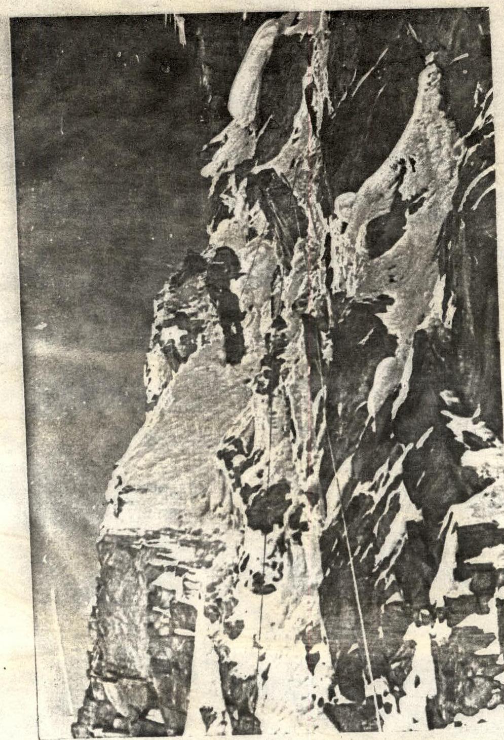
Section of the route R4–R5, first rock belt. August 4, 1987, 11:00, I-50, f=50 mm, l=70 m (c=30 m — see over).