Passport
- High-altitude class
- Tian-Shan, South Inylchek Glacier
- Khan-Tengri peak, via the center of the East Face
- Assumed 6B category of difficulty, first ascent
- Elevation gain — 2000 m, route length — 2420 m
Length of sections with 5–6B category of difficulty — 1340 m. Average steepness of the main part of the route — 67° (5000–6700 m). Including:
- 80° (80 m)
- 85° (140 m)
- 90° (80 m)
- Number of pitons used:
| rock | bolt | chocks | ice screws |
|---|---|---|---|
| 110/38 | - | 62 | 222 |
| - | - | 14 | - |
- Team's total climbing hours: 95 hours and 12 days
- Overnight stops: 1st — snow-ice ridge, 2nd — snow-ice ridge, 3–4th — snow-ice ridge, 5–6th — snow-ice ridge, 7–8th — snow cave, 9th — snow-ice ridge, 10th — snow-ice ridge, 11th — snow depression, 2, 7–11th — bivouacs in a lying position, 1, 3–6th — semi-reclining
- Team leader: Evgeny Nikolayevich Darmin — Master of Sports of the USSR
Team members:
- Georgy Danilovich Guber — Candidate Master of Sports of the USSR
- Alexey Viktorovich Kalashnikov — Candidate Master of Sports of the USSR
- Valery Vasilyevich Korolev — Candidate Master of Sports of the USSR
- Valery Alekseyevich Salfetnikov — Candidate Master of Sports of the USSR
- Vasily Vladimirovich Shpeg — Candidate Master of Sports of the USSR
- Coach: Valery Georgievich Denisov
- Approach to the route — August 8, 1988
Summit — August 19 Return — August 21
- Organizing body — State Committee for Physical Culture and Sports of the Kyrgyz SSR
Khan-Tengri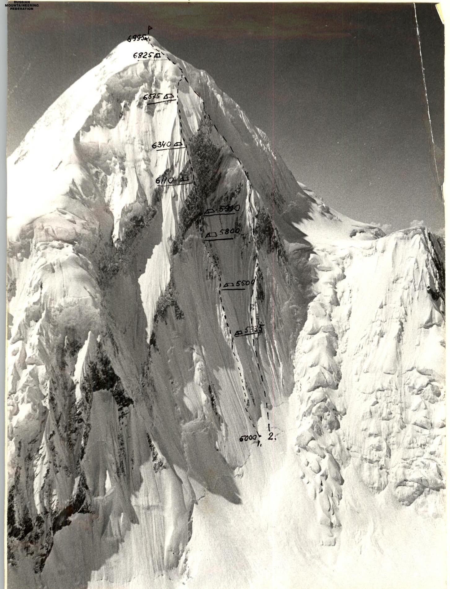
- Route taken by the team from the Kyrgyz State Committee for Sports.
- Route taken by the team from the Kazakh Alpine Club.
Photo taken on August 29, 1988, at 13:00. Lens: Helios 44M-4, focal length 58 mm. Point 1. Elevation 5800 m.

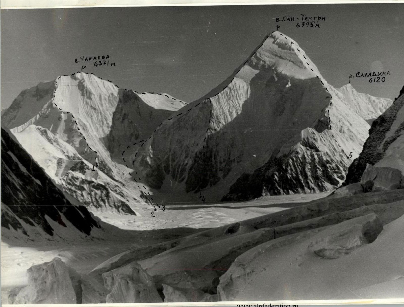
Photo. Profile of the East Face of Khan-Tengri peak from the south (left). Photo taken from the Razorvaniy Glacier. Point #2. Lens: 38 mm. Helios 44M-4. Taken on July 26, 1988, at 12:00, distance to object 1.4 km, 4800 m.
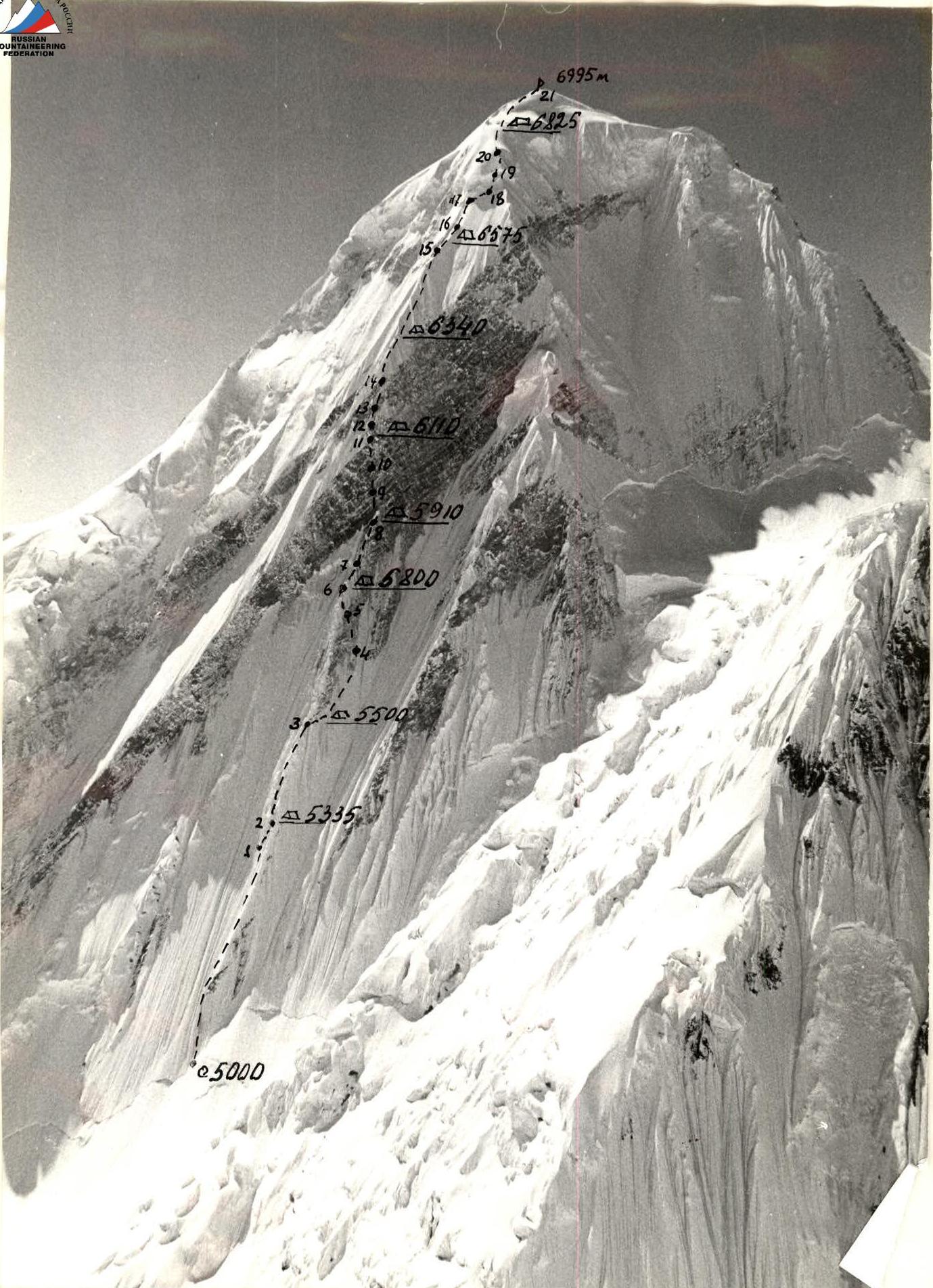
Profile of the wall on the right — locations of overnight stops. Taken on August 10, 1988, at 13:00. Lens: Helios 44M-4, focal length 58 mm, distance to the wall 2000 m. Point #3, 5700 m. Photo. Panoramic photograph of the area. Taken from the upper reaches
Technical Actions of the Team
Despite thorough reconnaissance and overflights of the route, it was not possible to fully assess all the complexities of the route and weather conditions. For instance, the snowy ridge on a rocky base under the rock wall (sections R4–R6), filled with cornices and sheer ice flows, turned out to be significantly more challenging than anticipated due to:
- difficulties in organizing protection;
- technical difficulties.
The first bivouac was as planned, but the second bivouac was significantly lower than planned due to weather conditions and route complexity. In fact, only the third bivouac was at the location of the second planned bivouac.
On days with bad weather, it was impossible to work due to constant small avalanches falling from above. Instead of the expected good weather during the ascent period, there was bad weather on:
- August 9
- August 11
- August 13
- August 15
- August 19
During the ascent, a significant amount of snow accumulated in the upper part of the wall (R16–R20) — on the snowy ridges, the thickness reached up to 1.5 m, which slowed down the team's pace. Thus, all deviations from the tactical plan were due to objective circumstances.
Team members moved along the route using fixed ropes (even on the R20–R21 section to ensure safe passage through deep snow and protection from avalanches). The lead climber worked with a double rope at all times (one of which was type 1 UIAA). The group used six ropes, allowing them to set up three fixed rope lines simultaneously; the remaining three ropes were used for protection. The type 1 UIAA rope was used for protection in the first rope team (lower protection for the 1st climber and upper protection for the 2nd climber). The other five Soviet-made ropes were used for fixed ropes and protection for the 1st, 3rd, and 6th climbers.
Each participant, while moving along the fixed ropes, had upper protection (except for the 3rd climber) and pulled up another rope behind them (the 3rd climber, moving along the fixed ropes, had only lower protection).
The team moved in two groups:
- 1st, 3rd, 5th climbers,
- followed by 2nd, 4th, and 6th.
The group moved at the pace of the leading pair, who worked almost independently. The task of the others was to timely pass on freed ropes, pitons, and carabiners to them from below.
On the route:
- The lead climber worked without a backpack at all times,
- the second and sixth climbers — with lightened backpacks.
On challenging sections, backpacks were pulled up as follows:
- a backpack is suspended on a safety rope 2.5–3 m from the end of the rope;
- having climbed 2.5–3 m, a climber, with the help of a belayer, pulls the backpack towards themselves;
- after that, the belayer secures the rope, and so on.
With this method, pulling up a backpack occurs simultaneously with moving along the fixed ropes. Pulling up a backpack is significantly easier because:
- it does not get caught on protrusions,
- it does not get stuck anywhere,
- there is a significantly lower probability of dislodging a "live" rock,
- no additional rope is required for hauling.
The lead climber was changed every 2–4 rope lengths, depending on the complexity of the sections; on the rock belt — every 1–2 rope lengths. The lead climber tried to work with maximum effort, as the speed of the entire group (with this movement scheme) depends by 90% on the leader.
The movement regime was as follows: departure after a hot breakfast at 8:30 and work until 18:00–19:00, followed by a hot dinner; lunch was eaten as a dry ration.
Most bivouacs were in a lying position, on convenient snow "stumps" on the ridge. One bivouac was in a prepared cave. On bivouacs, mandatory protection was organized for all participants. There were no falls or injuries on the route.
The challenging sections on the route were the snowy corniced ridge on the rocky base (R4–R6), the rock belt (R8–R11), and the summit dome with an ice drop (R17–R18). The snowy corniced ridge with "feathers" had to be traversed with an additional bivouac. Passing it and bypassing the upper part required the team to mobilize their moral and physical qualities, as it was a very steep and complex snowy terrain filled with cornices. The group could not approach the wall along the ridge — they had to bypass its upper part on the right.
The rock belt, despite its steepness (85–90°), had a tiled structure and was heavily covered in snow and ice. The rocks were very complex, traversed according to the tactical plan with preliminary processing and using artificial aids.
The summit dome, after all the days of bad weather, was heavily loaded with snow (more than 1 m) — soft and loose. It required maximum effort and caution due to avalanche danger and difficulty in organizing protection.
Four additional bivouacs exhausted the team, but they spent their strength relentlessly to complete the ascent at a fairly high pace.
In bad weather conditions, the team processed small sections, as it was impossible to work due to falling snow.
Communication with the observation group, intermediate and base camps was maintained via 79 RTP radios at 9:00, 14:00, 18:00 — main sessions, and at 12:00, 16:00, 20:00 — reserve communication sessions.
Rescue team:
- six people were stationed under Slantseviy peak (4250 m) until the team reached the summit dome;
- then four people ascended to 6400 m along the SW slope of Khan-Tengri peak;
- two doctors went to the 5800 m saddle between Khan-Tengri and Chapayev peaks;
- four members of the rescue group were stationed at the confluence of Semenovsky Glacier and South Inylchek Glacier.
The observation group was under the route until the team reached the summit dome.
OK. 30x. 411. 160. (1)
| Ox. | 30x | w / A | 100 | ||
|---|---|---|---|---|---|
| 100 | 30% | - | 200 | 95. X. 2 | |
| - | - | - | 0 | ||
| - | - | - | 9 |
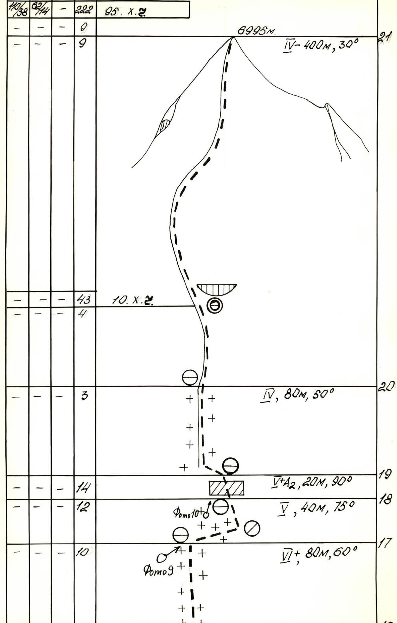
Description of the Route by Sections
Section R1–R2. Very steep ice gully. Ice is porous. It is necessary to chop off 40–50 cm of ice to organize reliable protection.
Section R2–R3. Snow-ice ridge. Sections of pure ice alternate with sections of very deep loose snow and overhanging snow-ice cornices. To organize protection on deep snow, it is necessary to tamp down the area for securing the fixed ropes on an ice axe or dig 1–1.5 m of snow to screw in an ice screw.
Section R3–R4. Steep accretion ice on the boundary between rocks and the ice gully (it is dangerous to go through the ice gully due to the risk of avalanches). The top layer has to be chopped off to screw in ice screws; otherwise, the ice flakes off. There are practically no cracks in the rocks, or they are filled with ice.
Section R4–R5. Steep internal corner filled with a thin layer of ice. A lot of time is spent on:
- cleaning the rocks,
- searching for cracks to hammer in pitons,
- most cracks are filled with ice.
The rocks have a tiled structure, with few holds.
Section R5–R6. Steep accretion ice; in the upper part, when exiting onto the ridge, there is very steep loose snow and a 1.5 m snowy cornice. When exiting onto the cornice, it was necessary to dig a trench.
Section R6–R7. Sharp snowy ridge turning into an ice slope. At the beginning of the ridge, there are cornices. When bypassing the cornices, it is necessary to dig trenches in loose deep snow.
Section R7–R8. Rocky wall covered in ice and snow. After bad weather, snow remains even on very steep sections. It is very difficult to find a place to hammer in a piton. The character of the rocks is the same as in section R4–R5.
Section R8–R9. Rocky wall. The rocks are loose; when hammering in pitons, they crumble. There are very few holds, and those are covered in ice.
Section R9–R10. Monolithic vertical wall. Mostly artificial climbing. The rocks are large-block, with few cracks. Practically all holds face downwards.
Section R10–R11. Round rocks heavily covered in ice, especially in the upper part. Very complex climbing. All holds have to be cleaned of ice and snow; hands freeze.
Section R11–R12. The character of the rocks is the same as in section R10–R11, but slightly easier; traversed with free climbing.
Section R12–R13. Ice gully with sections of rocks almost completely covered in a thin layer of ice. When traversed, the ice flakes off.
Section R13–R14. Internal corner heavily covered in ice, with short sections of ice. Traversed mainly using ice axes. Using ladders is difficult because the cracks are filled with ice.
Section R14–R15. Ice-snow ridge. Traversed 5–6 m from the top of the ridge, as there are sections of pure ice below the ridge (where protection can be organized). At the junctions of snowy ridges, there is very deep loose snow (up to 1.5 m); it is necessary to dig a trench.
Section R15–R16. Snowy ridge with deep snow. The problem is organizing protection. It takes a long time to compact the snow to hammer in an ice axe.
Section R16–R17. Snow-ice slope. The snow is deep and loose.
Section R17–R18. Ice wall under a snowy cornice. The ice flakes off in slabs. Working with front points of crampons is very difficult due to the altitude — 6700 m.
Section R18–R19. Ice cornice; traversed using ice axes. It was very difficult to transition from the wall to the snowy slope due to very deep loose snow.
Section R19–R20. Snowy ridge with deep loose snow. The lead climber digs a trench. The second climber treads down the path. Protection and securing of fixed ropes on ice axes. The fixed ropes greatly aid movement through loose snow, as the steps barely hold.
Section R20–R21. Snowy, not clearly defined ridge. Steep ascents alternate with more gentle sections. The snow is deep and loose.
Section R7–R11. The third climber reaches the location of the 5–6th bivouacs.
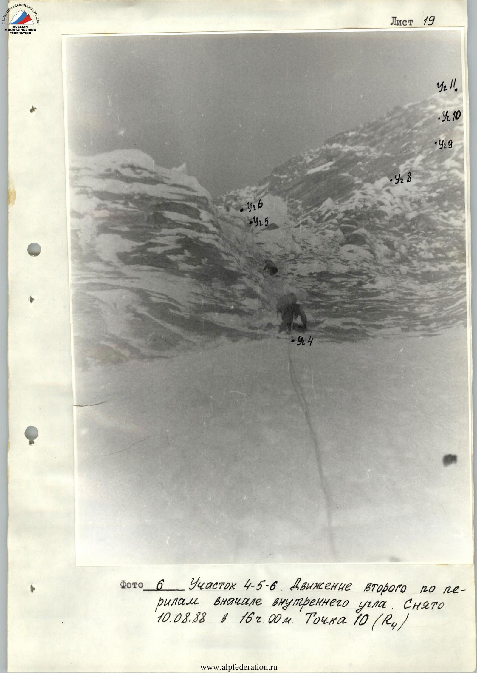
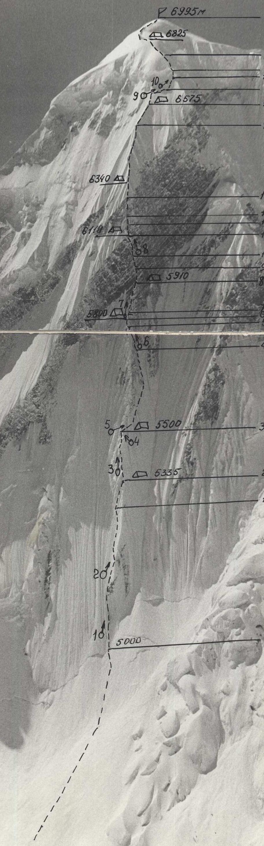
Photo. Technical photograph of the route on August 29, 1988, at 13:00. Lens: Helios 44M-4, 58 mm. Distance 3 km.
- Elevation of the shooting point 5800 m.
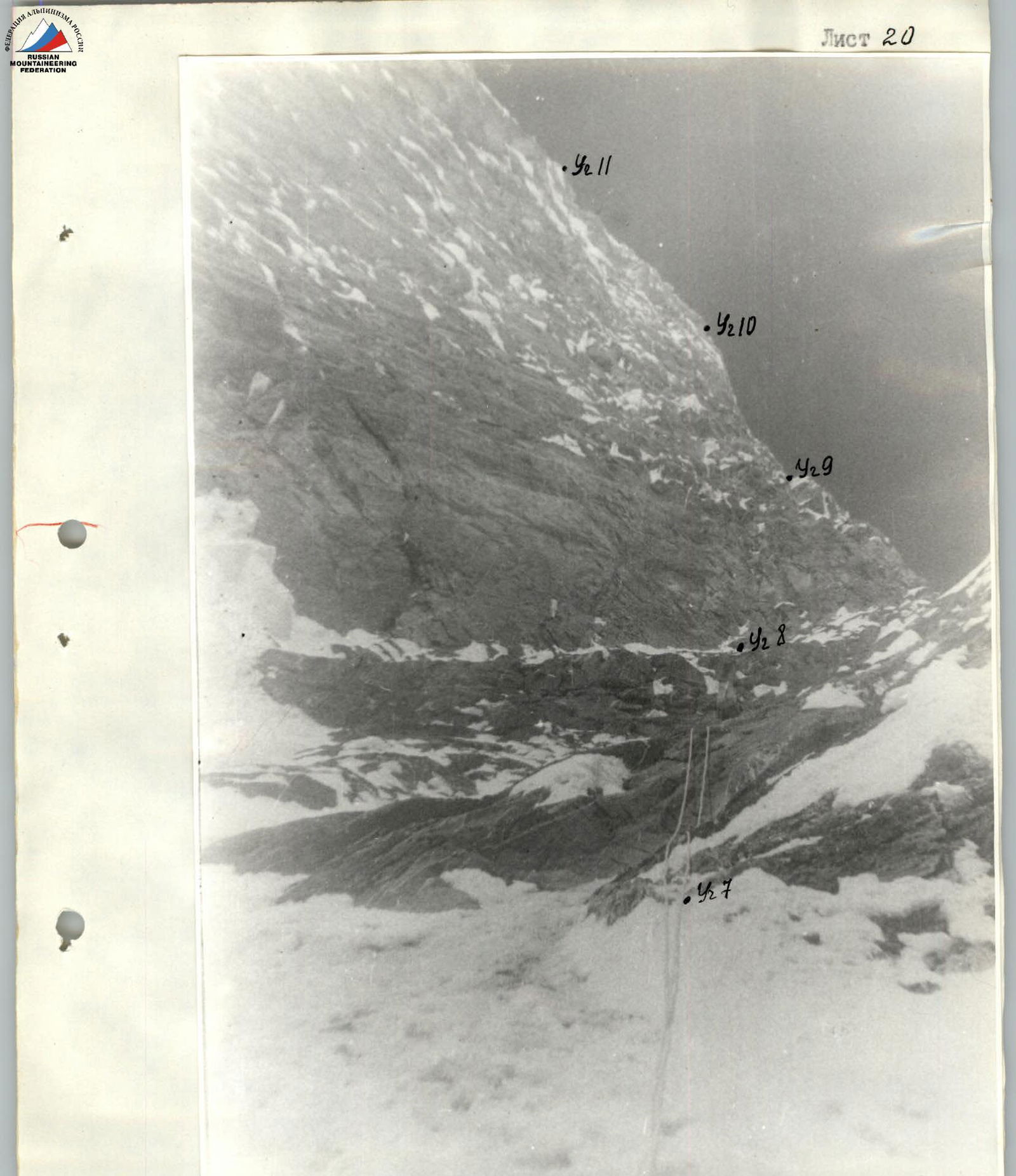
Photo. Section R7–R11. The third climber reaches the location of the 5–6th bivouacs. Taken on August 12, 1988, at 13:00. Point 11 (R6–R7).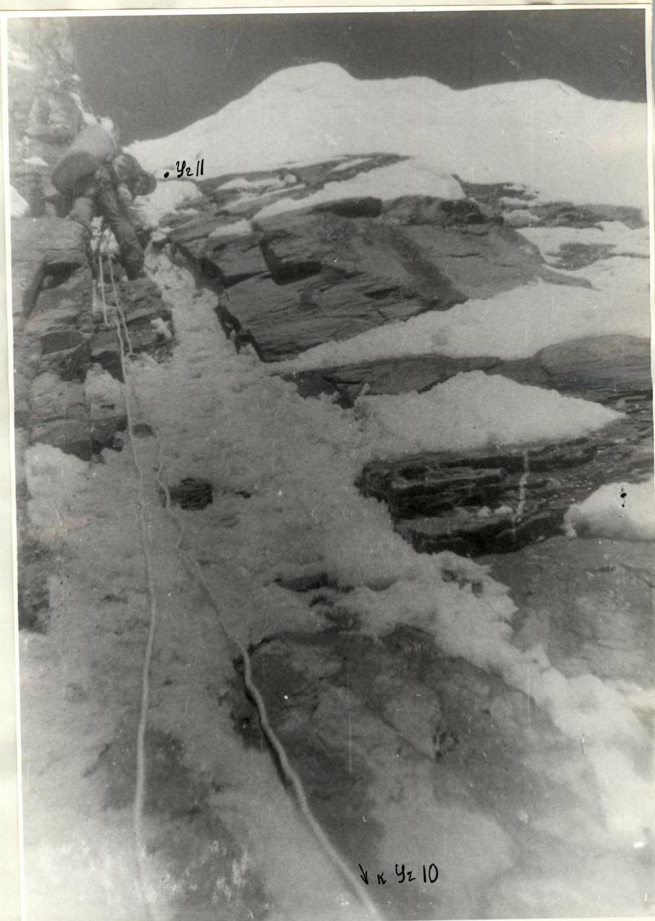
Photo. Section R10–R11. The fifth climber moves along fixed ropes. Taken on August 14, 1988, at 19:00. Point 12 (R10–R11).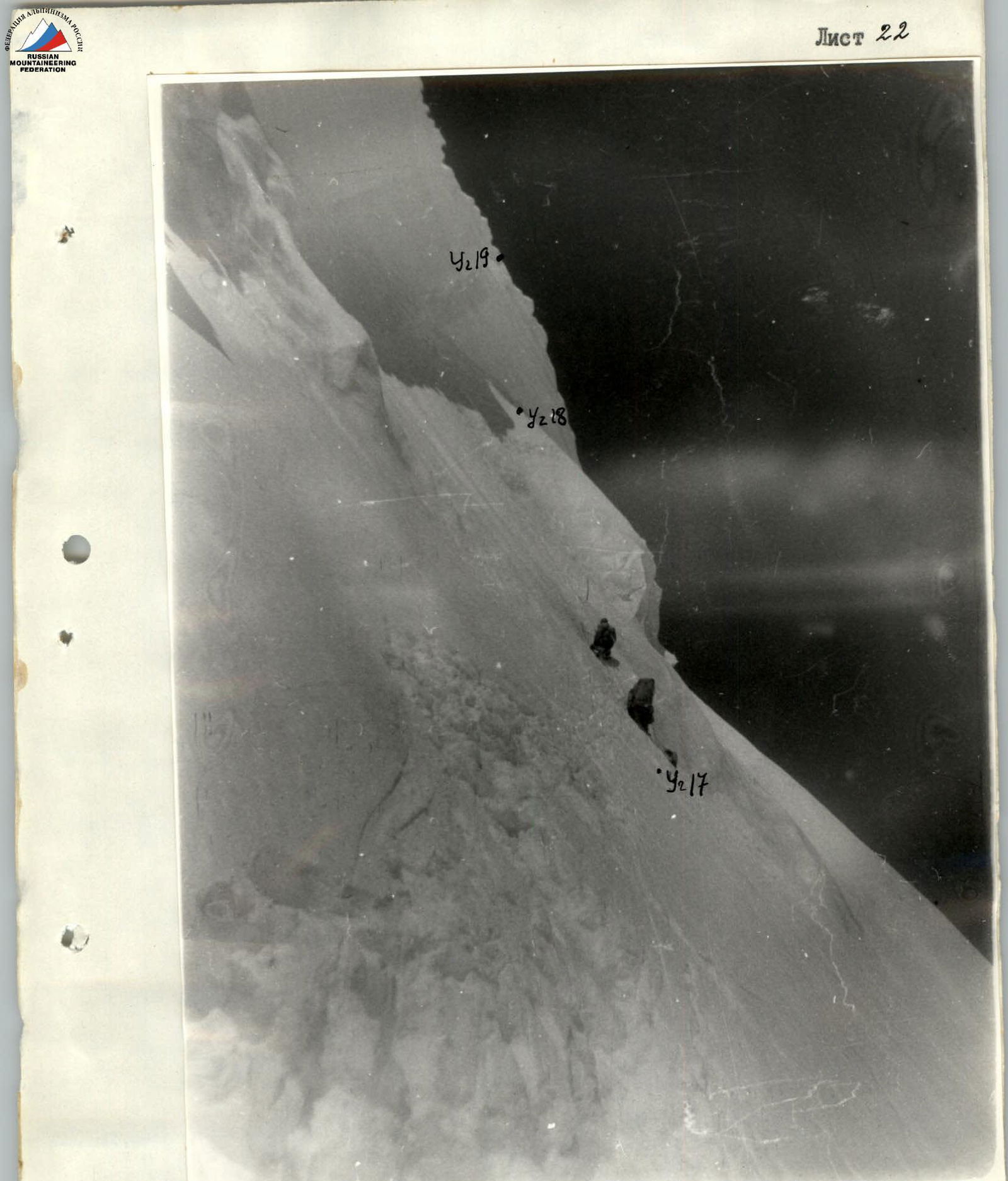
Photo. Section R17–R19. The third climber moves along fixed ropes. Taken on August 18, 1988, at 13:00. Point 13 (R17).