Passport
- CATEGORY OF CLIMBING ROUTE.
- TIAN-SHAN, TENGRI-TAG RANGE.
- Peak KHAN-TENGRI VIA LEFT PART OF NORTH FACE.
- PROPOSED 6B cat. dif., FIRST ASCENT.
- ALTITUDE DIFFERENCE 2700 m, ROUTE LENGTH 3920 m.
- LENGTH OF 5–6 cat. dif. SECTIONS — 1405 m.
LENGTH OF 6 cat. dif. SECTIONS — 375 m. AVERAGE STEEPNESS OF THE WALL PART OF THE ROUTE — 61°.
- PITS SET:
| ROCK PITS | ICE SCREWS | PLACED PROTECTION |
|---|---|---|
| 147/1 | 141 | 100/2 |
- CLIMBING HOURS — 56, DAYS — 7.
- BIVOUACS: 1st — hanging on a steep ledge, the rest — lying on platforms.
- TEAM LEADER AND COACH: POGORELOV ALEKSANDR GRIGORIEVICH — Master of Sports of International Class
TEAM MEMBERS:
- MOISEEV ALEKSANDR ANATOLIEVICH — Candidate for Master of Sports
TEAM MEMBERS:
- KOSHELENKO YURI VLADIMIROVICH — Candidate for Master of Sports
- NIKITENKO VIKTOR BORISOVICH — Candidate for Master of Sports
- APPROACH TO THE ROUTE: August 9, 1993.
SUMMIT: August 15, 1993. RETURN TO BASE CAMP: August 16, 1993.
- ORGANIZATION: ROSTOV REGIONAL FEDERATION OF ALPINISM AND ROCK CLIMBING.
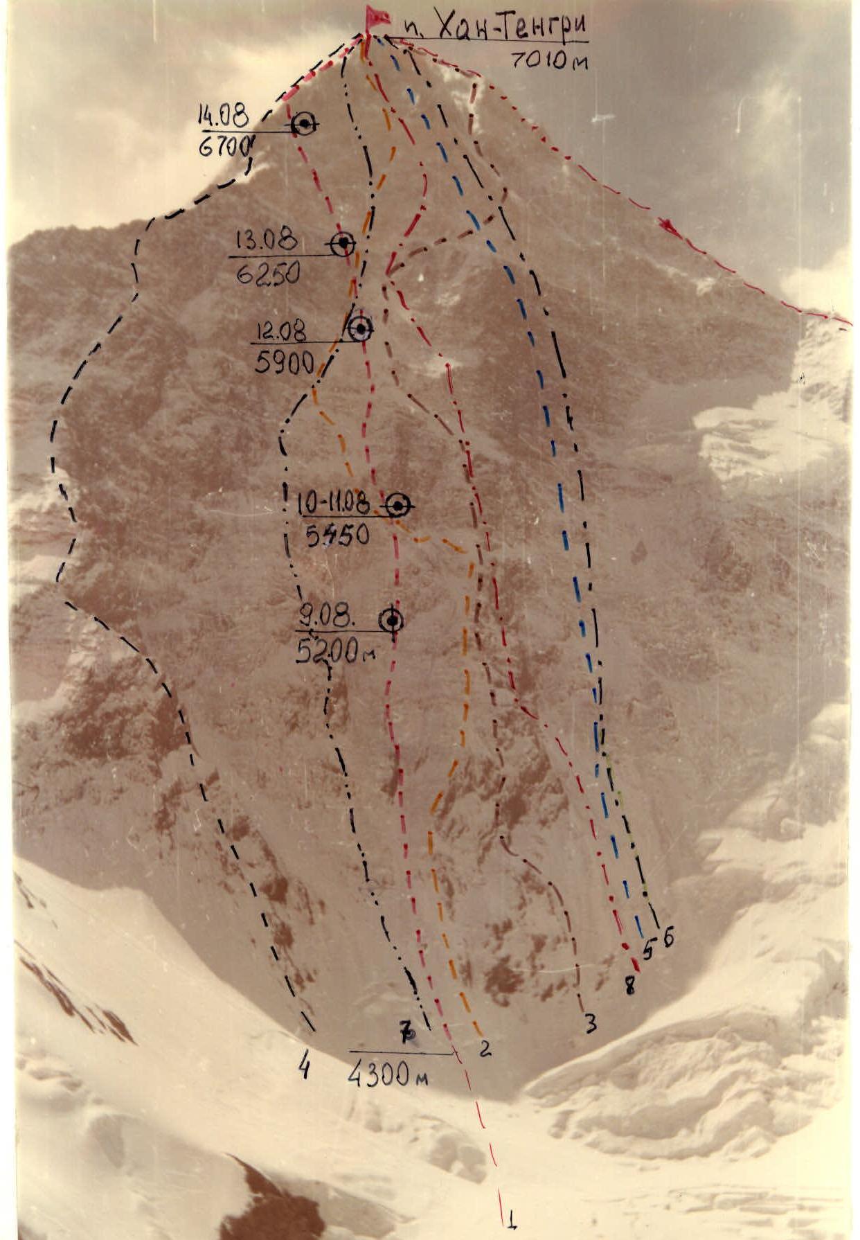
PHOTO 1. GENERAL PHOTO OF PEAK KHAN-TENGRI. August 8, 1993. 12:00. CAMERA "Yashica — 2000", F=70 mm. SHOOTING HEIGHT 4500 m. DISTANCE TO OBJECT 4000 m. SHOOTING POINT 1.
- — TEAM'S ROUTE
- — STUDENIN'S ROUTE 1974 6B cat. dif.
- — MYSLOVSKY'S ROUTE 1974 6B cat. dif.
- — KHUDYAKOV'S ROUTE 1974 6A cat. dif.
- — ZAKHAROV'S ROUTE 1988 6A cat. dif.
- — MOISEEV'S ROUTE 1988 6A cat. dif.
- — GORBENKO'S ROUTE 1987 6B cat. dif.
- — KOROTEEV'S ROUTE 1986
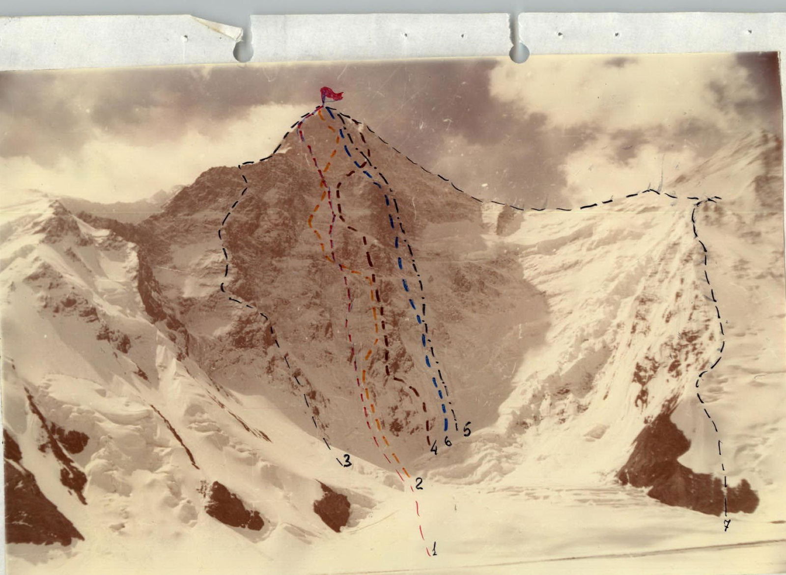
Photo №4. Photopanorama of the area on August 8, 1993. Camera "Yashica". Focal length 35 mm. Shooting point №1. Height 4300 m. Distance to object 4000 m.
- — route of FAiS team.
- — Studenin's route.
- — Khudyakov's route.
- — Myslovsky's route.
- — Moiseev's route.
- — Zakharov's route.
- — route along N face and W ridge 5B cat. dif.
Tactical Actions of the Team
The first day of the ascent largely corresponded to the tactical plan. Since the team had a high pace of advancement, they managed to cover 1000 m of the route on the first day. The overnight stay on the I bastion was hanging, with the tent used as a hammock for 4 people.
On the following day, as well as in the subsequent period, the team's tactical actions were shaped by the prevailing weather conditions. Constantly falling snow accumulated on the upper sections of the wall, triggering powder avalanches. The route was chosen logically, which helped avoid being caught in the path of large masses of freshly fallen snow.
The second overnight stay was comfortable, located at the base of the 2nd bastion. This bivouac was used twice: on August 10, 1993, and August 11, 1993, as the storm on August 11, 1993, allowed for only 3 ropes to be covered.
The movement on August 12, 1993, and August 13, 1993, took place under conditions of heavy snowfall and constant avalanches. On August 14, 1993, the team began moving along the marble belt. Due to the high avalanche danger in the central part of the marble bastion and the logic of advancement, a decision was made to alter the route. The final bivouac was set up 100 m from the NE ridge in a rocky niche, protected from wind and avalanches. On August 15, 1993, at 17:00, the team reached the summit of Peak Khan-Tengri.
The organization of the work of the rope teams was based on the principle of optimal distribution of the team's strength. The work of the leaders was distributed as follows:
- Pogorelov A.G. — sections R1–R5, R11–R18, R21–R25, R32–R41
- Nikitenko V.B. — sections R6–R10, R19–R20, R35–R36
- Moiseev A.A. — sections R42–R47
- Koshelenko Y.V. — sections R26–R31
- Section R0–R1 — autonomous.
The main problem during the route was very poor snow conditions, requiring special climbing techniques and strong physical endurance.
The first climber worked on a UIAA 12 mm rope, with belay through an improved "bug" by Kosheunik. The belay point was organized from three elements, balanced by a load-sharing loop. The movement of the other participants was along the fixed ropes with belay.
During the ascent, constant radio contact was maintained with observers and the rescue team.
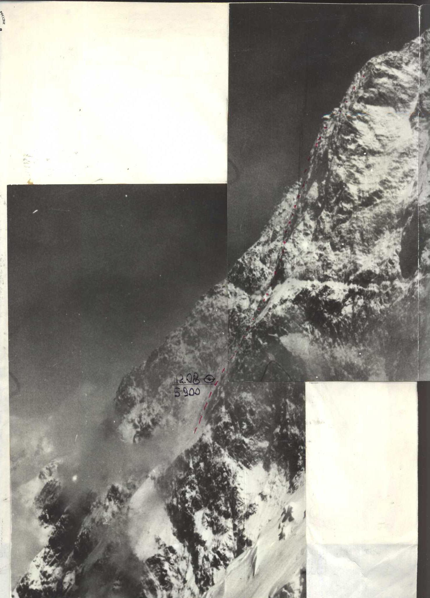
Photo №2. Profile of the wall on the right. August 11, 1993. 16:00. Camera "Smena". Distance to object 500 m. Shooting point №2. Height 6000 m.
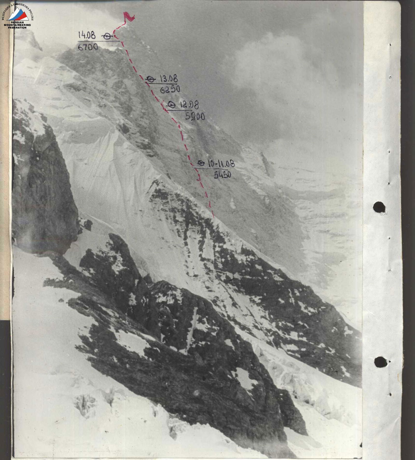
Photo №3. Profile of the wall on the left. August 8, 1993. 12:00. Camera "Smena". Shooting point №3. Height 4000 m. Distance to object 1000 m.
| 1 | 2 | 3 | 4 | 5 | 6 | 7 | 8 |
|---|---|---|---|---|---|---|---|
| 21 | 76 | 18 | August 9, 1993. Climbing hours 12 | 1075 | |||
| 2 | 1 | 1 | R22 | R11–R12 | 25 | 85 | VI |
| R21 | R10–R11 | 5 | 65 | IV | |||
| 13 | 15 | R20 | R9–R10 | 135 | 75–80 | V–VI | |
| R19 | |||||||
| 3 | 2 | R18 | R8–R9 | 25 | 75 | V | |
| 2 | R4 | R7–R8 | 10 | 75 | V | ||
| 9 | R16 | ||||||
| 8 | R15 | R6–R7 | 140 | 55 | IV | ||
| R14 | |||||||
| 6 | R13 | R5–R6 | 50 | 70 | VI | ||
| R12 | R4–R5 | 60 | 60 | IV | |||
| 14 | R11 | R3–R4 | 100 | 80 | VI | ||
| 20 | R10 | ||||||
| R9 | R2–R3 | 250 | 55 | V | |||
| R8 | |||||||
| 1 | 3 | R7 | |||||
| R6 | R1–R2 | 50 | 60 | V | |||
| 15 | R5 | ||||||
| R4 | R0–R1 | 250 | 50 | V | |||
| R3 | |||||||
| R2 | |||||||
| R1 | |||||||
| R0 | |||||||
| 30 | 0 | 9 | August 12, 1993. Climbing hours 8 | 630 | |||
| 12 | - | - | R26–R27 | 250 | 55 | IV | |
| 2 | - | - | R25–R26 | 10 | 75 | IV | |
| 3 | - | 2 | R24–R25 | 50 | 50 | IV | |
| 5 | - | 7 | R23–R24 | 120 | 70 | IV | |
| 8 | - | - | R22–R23 | 200 | 55 | IV | |
| 12/1 | - | 11/2 | August 11, 1993. Climbing hours 7 Overnight stay on section R16–R17 | 130 | |||
| 2/1 | - | 4/2 | R21–R22 | 25 | 85 | VI | |
| 1 | - | 1 | R20–R21 | 10 | 70 | V | |
| 2 | - | 2 | R19–R20 | 20 | 75 | V | |
| 2 | - | - | R18–R19 | 15 | 60 | IV | |
| 5 | - | 6 | R17–R18 | 60 | 75 | V | |
| 14 | 15 | 13 | August 10, 1993. Climbing hours 8 | 345 | |||
| 3 | - | 1 | R16–R17 | 10 | 50 | II | |
| 3 | - | 1 | R15–R16 | 20 | 85 | VI | |
| 4 | - | 5 | R14–R15 | 50 | 80 | VI | |
| 3 | - | 2 | R13–R14 | 40 | 65 | V | |
| - | 15 | - | R12–R13 | 200 | 55 | IV | |
| R70 | R46–R47 | 100 | 30 | II | |||
| 6 | - | - | R69 | R45–R46 | 100 | 60 | V |
| 5 | - | 2 | R67 | R44–R45 | 50 | 75 | V |
| 31 | 5 | 34 | August 14, 1993. Climbing hours 8 | 610 | |||
| 2 | 2 | - | R66 | ||||
| 2 | R65 | R43–R44 | 50 | 55 | IV | ||
| R64 | R42–R43 | 20 | 75 | V | |||
| 5 | 3 | 2 | R63 | R41–R42 | 120 | 55 | IV |
| R62 | |||||||
| R61 | R40–R41 | 90 | 65–70 | IV–V | |||
| 3 | - | 7 | R60 | R39–R40 | 50 | 70 | V |
| 6 | - | 5 | R59 | R38–R39 | 60 | 80 | V |
| 4 | - | 6 | R58 | R37–R38 | 50 | 75 | V |
| 3 | - | 6 | R57 | R36–R37 | 50 | 70 | V |
| 5 | - | 4 | R56 | R35–R36 | 50 | 75 | V |
| - | - | - | R55 | R34–R35 | 20 | 60 | III |
| 3 | - | 2 | R54 | R33–R34 | 50 | 70 | V |
| 27 | 11 | 26 | August 13, 1993. Climbing hours 6 | 490 | |||
| 4 | - | 5 | R53 | R32–R33 | 40 | 75 | V |
| 13 | - | 15 | R52 | R31–R32 | 180 | 70 | V–VI |
| 5 | - | 4 | R51 | R30–R31 | 60 | 70 | V |
| R50 | |||||||
| 2 | 8 | - | R29–R30 | 100 | 55 | IV | |
| 3 | - | 2 | R48 | R28–R29 | 40 | 70 | IV |
| - | 3 | - | R47 | ||||
| R27–R28 | 70 | 55 | IV | ||||
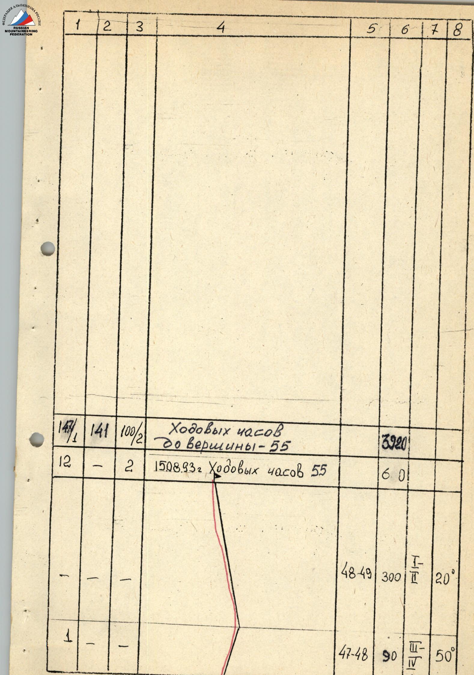
| 147/1 | 141 | 100/2 | Climbing hours to the summit — 55 | 3920 | |||
| 12 | - | 2 | August 15, 1993. Climbing hours 55 | 601 | |||
| - | - | - | R48–R49 | 300 | 20 | II | |
| - | - | - | R47–R48 | 90 | 50 | III–IV |
Description of the Route by Sections
R0–R1 — ice slope covered with a thin layer of snow (up to 5 cm). The large overall steepness of the slope does not allow snow to accumulate. Belay through ice screws.
R1–R2 — rocky outcrop with rimed ice. Belay through ice screws and rock pitons.
R2–R3 — ice slope similar to section R0–R1, but steeper.
R3–R4 — wide "chimney" with a large mass of rimed ice. More precisely, it's a sheer ice wall bounded on both sides by steep rock walls. "Ice fifi" were used during the passage. Belay through ice screws.
R4–R5 — wide snow-ice couloir. Belay through ice screws.
R5–R6 — wide "chimney" with a large mass of sheer ice, similar to section R3–R4.
R6–R7 — steep snow-ice slope. Due to the alternation of thin ice and snow, belaying is challenging. To organize belay, it was necessary to chop through the ice to reach the main layer.
R7–R8 — rocky wall plastered with snow. It was necessary to clear snow during passage. "Ice fifi" were used for passage. Piton belay.
R8–R9 — wide, "blurred" internal corner. Rocks are heavily snowed in. Tense climbing with the use of "ice fifi". Piton belay and placed protection.
R9–R10 — upper part of the first rocky bastion. Steep, heavily snowed-in rocks. "Ice fifi" were used in some places. Much time was spent clearing snow from rocks. Piton belay and placed protection.
R10–R11 — series of small ledges. The first overnight stay was organized here. The bivouac was hanging. The tent was used as a hammock.
R11–R12 — steep rocky wall with a slight overhang at the end. Belay through placed protection and pitons.
R12–R13 — steep snow-ice slope, ending in a vaguely defined ice-snow ridge and a "wrist" under the second rocky bastion. Belay through ice screws.
R13–R14 — wide, "blurred" couloir. Rocks covered with a thick layer of snow. Belay through rock pitons and placed protection.
R14–R15 — steep snow-covered rocks of the second bastion. Complex, tense climbing. Belay through rock pitons and placed protection.
R15–R16 — sheer wall with few holds. Ends in smooth, flattening, snow-covered slabs. Organizing belay is problematic.
R16–R17 — steep snow ledge. Snow is very deep. A snow platform was built, and an overnight stay was organized. Belay through:
- placed protection
- pitons driven into the rock at the top of the ledge.
R17–R18 — steep rocky slabs leading to a small ridge-shoulder. Slabs are heavily snowed in due to the previous day's weather.
R18–R19 — small rocky ridge leads to a steep wall. A control cairn with a note was left here.
R19–R20 — from the ridge, a traverse along the wall with rimed ice to the left towards a chimney, and then straight up to a small ledge. Complex, tense climbing. Difficulties with organizing belay.
R20–R21 — from the ledge, again left and up towards the start of the second chimney. Also, complexities with organizing belay due to the destroyed relief.
R21–R22 — chimney with an overhang at the top. Due to the destroyed rock, there are problems with organizing belay and passing the chimney. This is the technical key of the route. ITO was used for passage. The complexity of the passage was compounded by the onset of snowfall and powder avalanches.
R22–R23 — steep, snowy slope. Snow is deep. Organization of belay:
- through pitons driven into rocky outcrops protruding from the snow.
R23–R24 — rocky bastion. Walls alternate with small, steep snow ledges. Belay:
- piton belay
- through placed protection.
R24–R25 — steep snow-ice slope leading to a small rocky wall.
R25–R26 — steep rocky wall. Complex climbing. Rock is:
- fine-grained, crumbling granite.
R26–R27 — steep snowy slope. Problems with organizing belay. Belay through pitons driven into rocky outcrops. At the end of the section, under a large stone, an overnight stay was organized.
R27–R28 — continuation of the snowy slope.
R28–R29 — destroyed rocks. Belay through:
- rock pitons
- placed protection.
R29–R30 — snow-ice slope. Another snowfall occurred during its passage.
R30–R31 — steep rocky wall. Rocks are slightly destroyed. Due to continuing snowfall, avalanches started. Gathering on the marble triangle, they pass to the right of us. This forces us to move along steep rocks, although the relief is more gentle to the right. Snowfall seriously complicates our progress.
R31–R32 — more gentle rocks compared to the previous section. Due to snowfall, there are significant problems with climbing and organizing belay.
R32–R33 — steep rocky wall leading to a ledge. Complex, tense climbing, further complicated by deteriorating weather. The ledge found by us allows us to stop and organize a bivouac. Although the time is only 15:00, continuing the movement is impossible due to bad weather.
R33–R34 — after the ledge where the overnight stay was organized, non-steep but destroyed rocks lead to a small, gentle ridge under the marble rocky summit bastion. It is separated from the lower part of the wall by a small ledge.
R34–R35 — ascent with a slight traverse to the right along rocky slabs, slightly destroyed.
R35–R36 — rocks with relief in the form of a wide, "blurred couloir". Organizing belay is problematic.
R36–R37 — we move left to the left edge of the "blurred couloir". Here it's slightly steeper, but easier to organize belay. The weather starts to deteriorate, which will again lead to avalanches, and there's a possibility to hide from them on the left.
R37–R39 — steep rocks. Complex, tense climbing. Belay through rock pitons and placed protection.
R39–R40 — exit from the wall into a wide chimney filled with snow.
R40–R41 — wide chimney filled with snow. Difficulties with organizing belay.
R41–R42 — heavily snowed-in rocks of medium difficulty. Snowfall resumes.
R42–R43 — along the rocky wall, transition to a steep ice-snow couloir. Snowfall intensifies.
R43–R44 — along a steep ice-snow gully, approach to the start of a wide chimney. Snowfall continues, and we stop for the night.
R44–R45 — along a wide, steep chimney, exit to the ridge.
R45–R46 — steep snowy slope on the left side of the ridge. Problems with organizing belay. This forces us to move to the right, to the boundary of rocks and snow, and exit to the gentle part of the ridge along it.
R46–R47 — simple, gentle ridge. However, movement is slow due to very deep snow.
R47–R48 — steep snowy ascent. Snow is very deep, chest-high. Movement is slow as it's necessary to dig a trench to advance.
R48–R49 — simple, long, and gentle ridge leading to the summit.
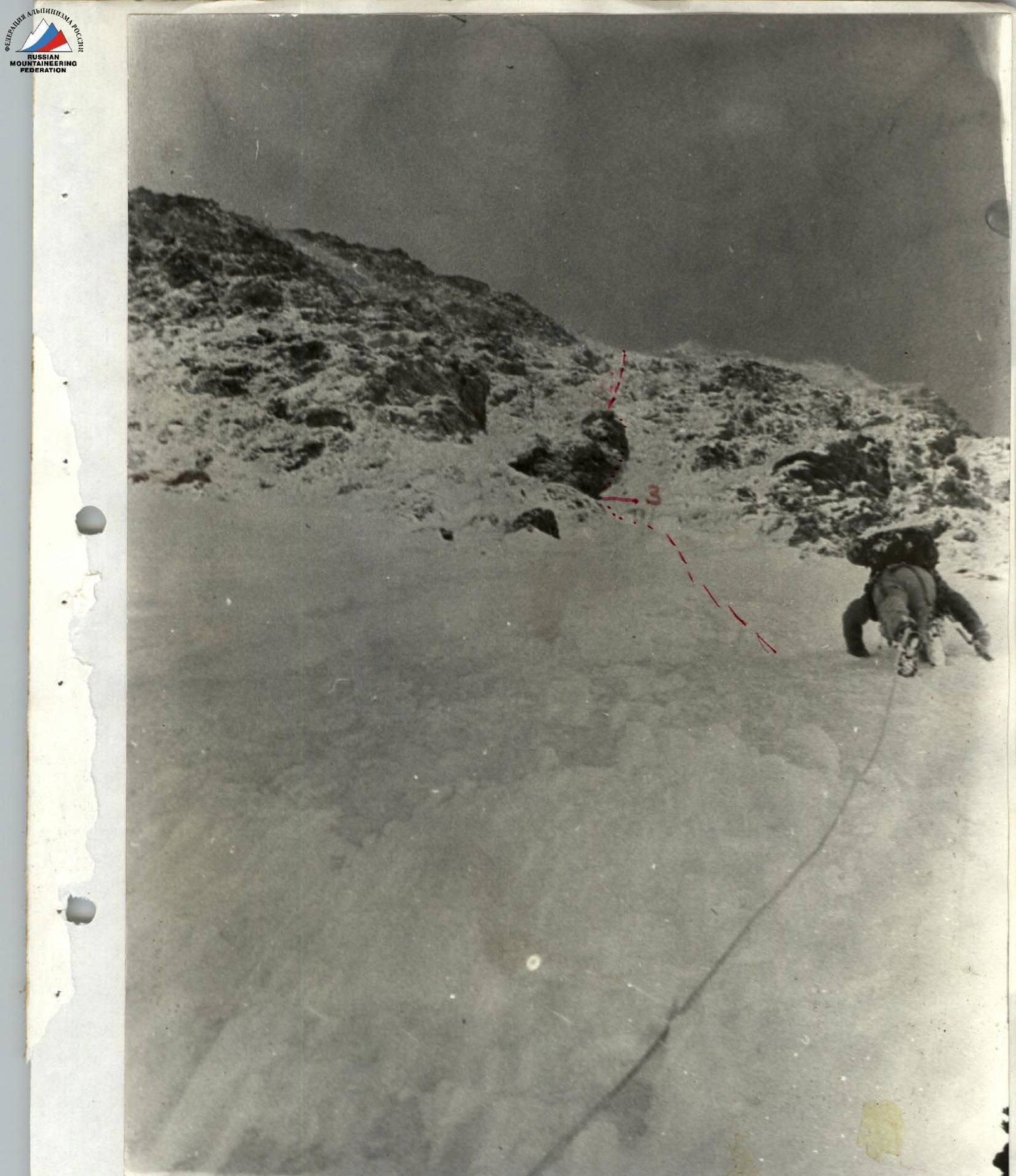
Photo №6. Start of the route. Section R0–R1. August 9, 1993. Camera "Smena". Shooting point №4.
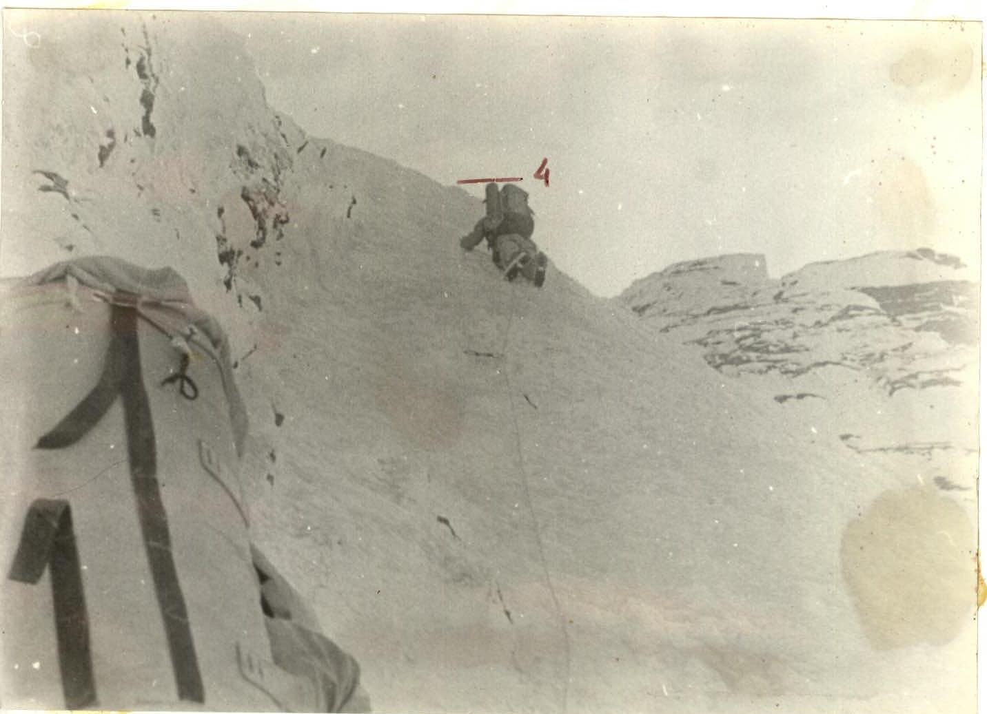
Photo №7. Passage of section R3–R4. August 9, 1993. Camera "Smena". Shooting point №5.
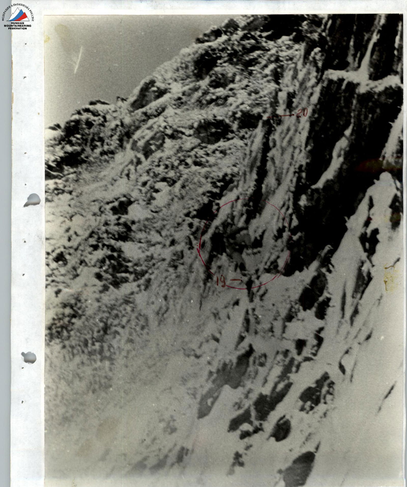
Photo №10. Entering the chimney. Section R18–R19. August 11, 1993. Camera "Smena". Shooting point №8.
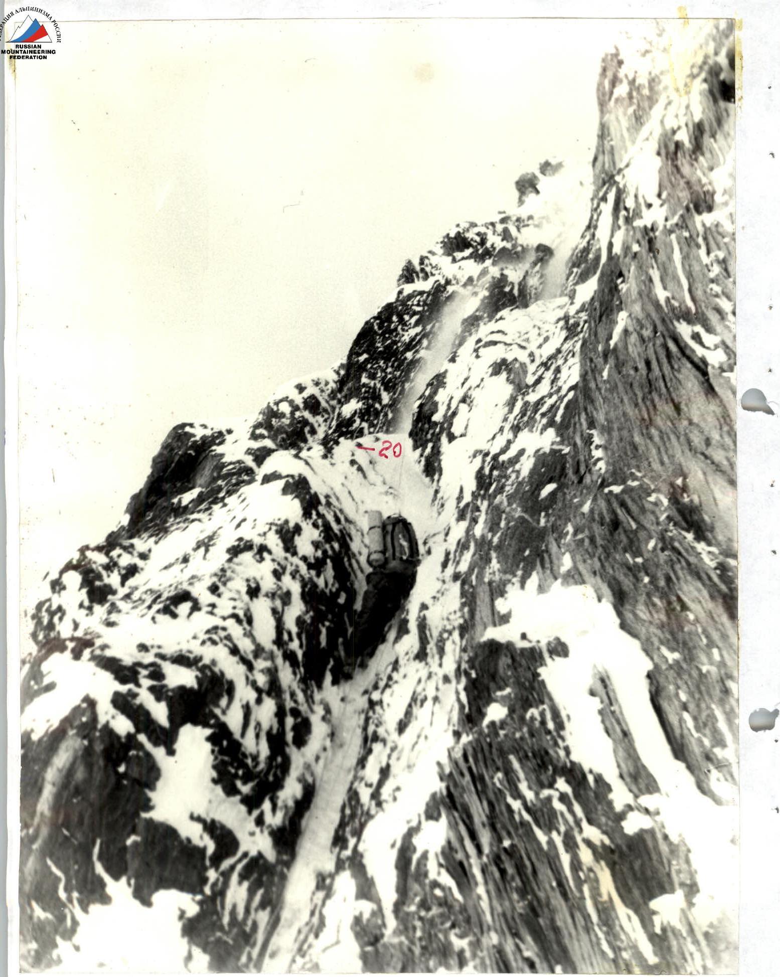
Photo №11. Passage of the chimney. Section R19–R20. August 11, 1993. Camera "Smena". Shooting point №9.