
1988 USSR Alpine Championship
High-altitude Climbing Category
Report on the Ascent to Khan-Tengri Peak (6995 m) via the Right Part of the North Face (First Ascent) by Team 12, SAVO Army Sports Club
All inquiries regarding the report should be directed to:
- City: Alma-Ata
- Postal Code: 480051
- Address: Army Sports Club, 12
- Position: Club Chief
- Name: Novikov Pavel Maksimovich
- Phone: 63-56-39
Ascent Leader: Moiseev Yuri Mikhailovich, Alma-Ata, microdistrict Taugul, building 35, apartment 19, home phone 29-63-74
Team Coach: Sedelnikov Viktor Nikolaevich, 480003, Alma-Ata, Dzerzhinsky Street, building 24, apartment 36, home phone 39-37-63
The absolute height data provided in this report are taken from the map. The height of camps, the level of the bergschrund of the glacier, and the base camp are based on reports from previous climbers (V. Koroteev, A. Studenin, etc.).
Passport
- Class: High-altitude.
- Region: Central Tien Shan, North Inylchek Glacier.
- Peak Khan-Tengri, 6995 m, via the right part of the North face.
- Proposed category: 6B, first ascent.
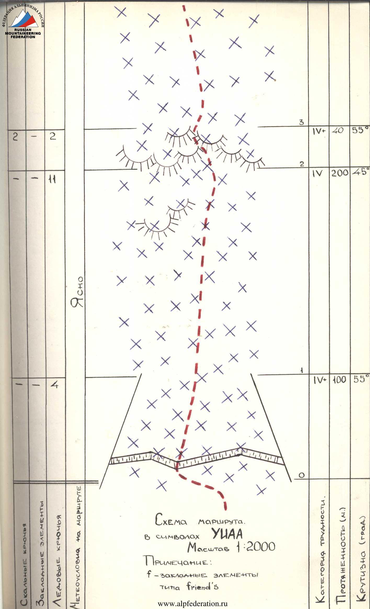
- Height difference — 2700 m, length — 3600 m (wall section) + 400 m (summit ridge). Length of sections with 5–6 category complexity — 1680 m (including 250 m of 6th category complexity). Average steepness of the wall section — 58° (4300–6850 m), average steepness of the "black wall" — 72° (5650–6200 m), with 6th category complexity sections: 70° (5060–5100 m), 80° (5915–5935 m), (5955–5965 m), (6070–6100 m), (6170–6180 m), 85° (5670–5710 m), (5780–5800 m), (6010–6020 m), 90° (5935–5955 m), (6020–6070 m).
- Number of pitons used:
| Rock | Bolt | Nuts | Ice |
|---|---|---|---|
| 189 | – | 85 | 74 |
| 14 | – | 3 | 0 |
-
Team's total climbing hours: 86.5 hours and days — 8.
-
Camps:
- 1–2 — sitting camp on an ice-rock shelf.
- 3–4 — lying camp on a constructed platform.
- 5 — semi-reclining camp on an inclined rock shelf.
- 6 — lying camp on a rock platform.
- 7 — sitting camp on a rock shelf covered with ice.
-
Leader: Moiseev Yuri Mikhailovich (MS)
Participants:
- Kovalenko Petr Konstantinovich (MS)
- Studenin Andrei Borisovich (MS)
- Tashmambetov Khudaybergen Sadvakasovich (CMS)
- Tugalev Vladimir Gennadievich (CMS)
- Tselishev Andrei Vasilievich (CMS)
-
Senior Coach: Ilyinsky Ervand Tikhonovich (Honored Coach of the USSR)
Coaches:
- Sedelnikov Viktor Nikolaevich (Honored Coach of the Kazakh SSR)
- Moiseev Yuri Mikhailovich
-
Departure on the route: August 10, 1988. Summit: August 17, 1988. Return: August 18, 1988.
-
Organization: Army Sports Club, 12 SAVO.
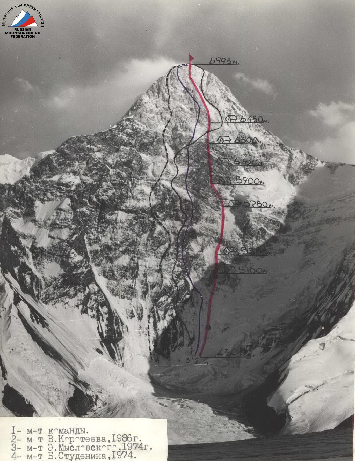
Photo # 1. General view of the summit. August 10, 1988, 17:00. Lens "Xenar" F-105 mm, distance 5 km, point # 3, height 4600 m.
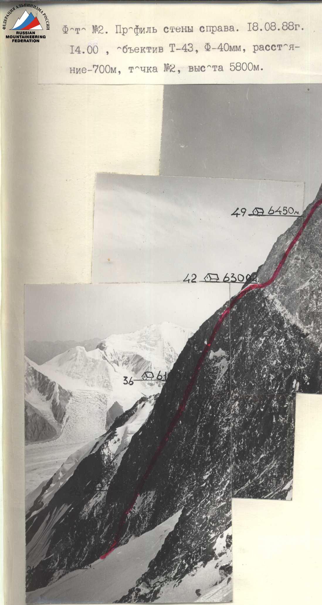
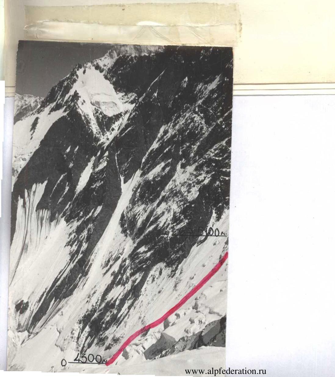
Photo # 3. Profile of the wall from the left. August 9, 1988, 14:00. Lens Industar-26, F-105 mm, distance 7.5 km, point # 1, height 4400 m.

Legend: from the observation point
- Route to Saladin Peak via the North face, 5B category.
- Route to Khan-Tengri Peak by K. Kusano, 5B category.
- Route to Khan-Tengri Peak by O. Khudkov, 6B category.
- Route to Khan-Tengri Peak by B. Studenin, 6B category.
- Route to Khan-Tengri Peak by V. Koroteev, 6B category.
- Route to Khan-Tengri Peak by E. Myslovsky, 6B category.
- Route to Khan-Tengri Peak by V. Khrishtchaty, 5B category (1988) — team's descent route.
- Route to Chapayev Peak (6731 m), 5B category.
Brief Overview of the Climbing Region
Khan-Tengri Peak is located in the eastern part of Central Tien Shan, in the Tengri-Tag ridge. The area is well-studied and developed for mountaineering.
Neighbouring peaks in the ridge:
- to the west — 6250 m (Galkin Peak) and Chapayev Peak (6371 m)
- to the east — 6200 m (Saladin Peak) and 6637 m (West Shater Peak)
The Tengri-Tag region is characterized by:
- high precipitation and, consequently, powerful glaciation
- harsh winds
- predominantly cloudy days and bad weather.
The base camp of the expedition was located on the North Inylchek Glacier, opposite the North face of Khan-Tengri Peak.
Observing the wall is convenient from the camp and from the eastern spur of the 6250 m peak.
The expedition was transported by helicopter from the village of KarNary. The approach to the wall via the North Inylchek Glacier is straightforward and takes no more than 3 hours.
Pre-Climb Preparation
General physical preparation was conducted at the SCA sports base and in the foothills of the Trans-Ili Alatau. Control normalcy tests were taken at the Tuyuksu base (altitude 2200 m) on May 23–24, 1988, during a gathering where selections for the Kazakhstan national teams were made. All team members passed the tests according to the USSR Championship methodology, scoring "excellent" and "good".
Improvement of technical skills for moving on complex rock terrain and practicing tactical and technical techniques in rope teams was conducted during training sessions at the rock climbing wall on the Ili River and in the Tuyuksu gorge.
Functional training was carried out in the mountains of the Trans-Ili Alatau. During the winter-spring preparation and at the gathering in Tuyuksu in June, participants completed up to ten ascents of 2B–4B category complexity.
Familiarization with the region and the object of the ascent was based on studying reports from previous ascents and materials from the Kazakh Mountaineering Club on Central Tien Shan (M. Grudzinsky, E. Kolokolnikov) and expeditions by 12 SCA in 1974 to the North Inylchek Glacier.
In the summer season of 1988, all team members had ascents on seven-thousanders (Central Pamir), and additionally, V. Tugalev and P. Kovalenko completed a series of complex technical ascents of 5B–6B category in the Ak-Su region (Pamir-Alay). The team captain has extensive experience in climbing in this region, including an ascent of Peak Pobeda via the "dollar" route in 1982, a traverse of East Pobeda — Main Pobeda in 1984, an ascent of Khan-Tengri Peak via the Sviridenko route, and a winter ascent of Lenin Peak in 1987.
Out of the two planned objectives, preference was given to the North face of Khan-Tengri, known in the mountaineering world for its complexity and harshness. Routes laid out on this face have consistently won gold medals. The most extensive and complex routes have been laid out on the central part of the wall. In our opinion, the right part of the wall presents the greatest technical difficulty, particularly the 700 meters of the "black wall" at an altitude of 5600 to 6300 m — the steepest part of the wall. Structurally, it is a series of vaguely defined spurs consisting of individual steep rock walls converging approximately at one point on a snowy shoulder under the yellow pre-summit wall. There are no convenient places for camps. The rocks are fragile, which suggested the possibility of artificially creating platforms (camps # 3, # 4). A particular difficulty could be the passage of rock belts covered in ice in the lower part of the route.
Given the geographical location, the considerable length (over 3.5 km) of the route, the harsh climatic conditions, and purely psychological factors of climbing in this region, special attention was paid to preparation and development of issues such as:
- organization of rope team movement (see "Tactical Plan" and "Tactical Actions of the Team"), taking into account individual technical mastery and high-altitude experience of the athletes;
- preparation of equipment, practicing techniques and insurance methods, with elongated pitons-clinches (35–40 cm) prepared for fragile rocks. For overcoming ice-covered rocks, the use of ice-axes and ice-hammers was planned. Insurance on stations was planned using a combination of rock and ice pitons;
- actions of the team and rescue team in case of an emergency situation, with options for passing and emergency descents from various sections of the route outlined (see "Tactical Plan"). Tactical safety measures included the deployment of a backup group via the northeast shoulder of Chapayev Peak and further along the western ridge during the team's ascent to the summit area.
Considering the special climatic conditions, particular attention was given to equipment. All participants had double plastic boots "Koflak" and a set of high-quality down gear. The group had a specially made insulated tent for 6 people. Particularly complex rock sections were planned to be climbed in galoshes.
Concerns were raised by the hanging glacier on the right part of the wall, from where pieces of ice and avalanches could fall. However, observations showed that the path of avalanches did not intersect with the planned route line, which was to start near the rock bastions in the lower part (see avalanche track on Photo 1).
For communication between the team and the base camp, a VHF radio station was used with a spare set of batteries. The base camp had long-range communication with:
- CSP Central Tien Shan
- Alma-Ata
- other expeditions in the Khan-Tengri region.
A rescue team led by Zhukov N.A. (CMS, 2nd category) consisting of eight people was stationed at the base camp under the North face of Khan-Tengri Peak. Members of the rescue team had completed three ascents on seven-thousanders in that season:
- Lenin Peak
- Communism Peak
- E. Korzhenevskaya Peak.
On August 15, five army participants from the USSR Himalayan alpine team arrived at the base camp, significantly increasing the potential capabilities of the rescue team.
On August 2, the expedition was transported by helicopter to the North Inylchek Glacier. From August 3 to 5, reconnaissance exits were made to the northeast shoulder of Chapayev Peak up to an altitude of 5600 m. The objectives of these exits were:
- reconnaissance of the path to the route
- study of the wall's relief
- clarification of the first ascent route
- selection of camp sites
- assessment of the danger from the hanging glacier on the right part of the wall
- determination of the possibility of photographing the wall from the right.
Observations were also conducted from the base camp using a 60x spyglass.
On August 9, the duo E. Sedelnikov and Z. Aubekirov ascended to the slopes of Marble Wall Peak to photograph the profile of the wall from the left.
On August 10, the duo V. Sedelnikov and I. Khanin ascended to the pass Eleven for photographing:
- a panoramic photo
- a general photo
- technical photography of the route.
Three cameras were planned to be taken on the route for photography.
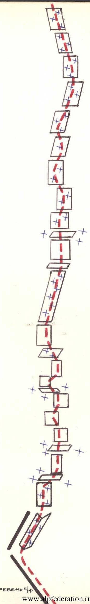
Ascent Schedule

Legend
- □ — clear, sunny
- * — cold, frost
- □ — cloudy, ground blizzard
- ** — very cold
- □ — bad weather, snowfall, strong wind
Tactical Actions of the Team
The team's actions during the ascent were determined by the tactical plan. The plan was largely fulfilled, with minor deviations due to the specific situation on the route, resulting in:
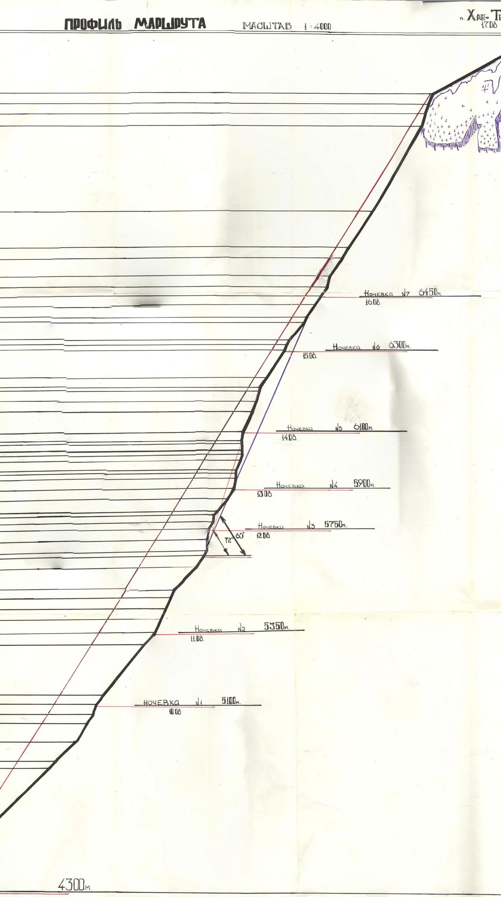
- a change in the number of camps on the route due to bad weather: seven instead of five. This situation was anticipated in the tactical plan, which included two reserve days for bad weather, which were utilized;
- a change in the location of camp # 2 to 60 m below the planned site due to safety concerns — under an overhanging part of the 2nd rock belt (R12).
The route was climbed without prior processing of its beginning. The ascent was primarily done by free climbing, except for sections: (R8–R9 (6 m)); (R13–R14 (3 m)); (R22–R23 (2 m)); (R28–R29 (3 m)); (R33–R34 (8 m)); (R39–R40 (2 m)); (R50–R51 (3 m)) — which required the use of artificial climbing techniques (ITE), as well as techniques like "pendulum" and "Zalzug".
Practically all participants worked as first on the route, taking turns and thus evenly distributing the physical and psychological load.
Each day of the ascent had a designated leading rope team. Team members agreed among themselves on the change of leaders within the team. The change of leading teams occurred on sections: R3–R4; R6; R9; R12; R14; R18; R22; R28; R32; R34; R36; R37; R41; R43; R49; R51; R54; R55.
The average duration of work for the first on the route was approximately 5 hours per day.
Schedule of rope team work on the route:
- August 10, 1988 (1st day)
- Leading team: Studenin — Moiseev — until 15:00
- Closing team: Kovalenko — Tselishev — until 19:00
- August 11, 1988 (2nd day)
- Leading team: Tashmambetov — Tugalev
- Closing team: Kovalenko — Studenin
- August 12, 1988 (3rd day)
- Leading team: Moiseev — Studenin
- Closing team: Kovalenko — Tugalev
- August 13, 1988 (4th day)
- Leading team: Tselishev — Kovalenko
- Closing team: Tashmambetov — Studenin
- August 14, 1988 (5th day)
- Leading team: Tugalev — Kovalenko
- Closing team: Moiseev — Tashmambetov
- August 15, 1988 (6th day)
- Leading team: Tselishev — Moiseev
- Closing team: Tugalev — Studenin
- August 16, 1988 (7th day)
- Leading team: Moiseev — Studenin
- Closing team: Kovalenko — Tashmambetov
- August 17, 1988 (8th day)
- Leading team: Tselishev — Tugalev
- Closing team: Tashmambetov — Kovalenko
During the ascent, in the second half of the day (excluding the 1st and 8th days), preliminary processing of the route was carried out simultaneously with the organization of a camp site (see UIAA scheme).
Ropes were organized along the entire route, except for:
- 1st day of ascent — sections R1–R2, R3–R4 — work on an ice slope by parallel rope teams. Insurance through ice pitons.
- 8th day of ascent — sections R51–R52, R53–R54 — movement by independent rope teams along hooks set by the "leading" team.
- 8th day of ascent — sections R58–R59 — simultaneous movement of rope teams.
Organization of movement and rest: each day of ascent included two hot meals (morning and evening). Around 14:00, there was a snack from individual packs (sausage, meat, chocolate, dried apricots, nuts, vitamins, drinks (tea, juice)) in flasks.
The team's movement regime is reflected in the ascent graph (sheet 6).
Camps were chosen and organized in safe locations, protected by cornices, awnings, or on the edge of a spur. Camp sites were studied by observing the wall. The effort put into setting up the platforms was fully justified by the quality of rest.
Problematic sections of the route included:
- Sections R6–R10, R12–R14 — rock belts covered in ice, requiring careful climbing in crampons with ice-axes and ice-hammers and combined insurance using rock and ice pitons (see Photo 3).
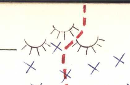
- "Black wall", sections R18–R42. Climbing the black wall required a wide range of technical means and techniques (Photos 5–11). The black wall is composed of slate rocks — non-uniform in structure and strength. The height difference is 700 m, with an average steepness (sections R18–R41) of 72°. The steepness of individual sections (20–40 m) reaches 85° or more (see UIAA scheme).
A wide selection of rock pitons and the use of various nut placements, including "friends", facilitated quick insurance organization and significantly eased the passage of this most problematic part of the route.
Climbing some complex sections of the "black wall" required artificial climbing on ITE using techniques such as:
- "Zalzug"
- "pendulum" (sections R13–R14; R22–R23; R31–R34; R50–R51).
The state of the wall's relief required the first climber to work:
- in crampons (Photo 11)
- in Vibram shoes (Photo 7)
- in galoshes (Photo 8).
Particularly challenging sections of the wall were:
- R32–R34 (see Photo 7)
- R34–R36 (see Photos 8, 9).
The first section is a crevice with a cornice and an overhang at the top, requiring complex climbing on ITE using "Zalzug" and significant physical effort when hammering pitons — the altitude and steepness of the wall took their toll.
The second section is also a crevice with a cornice — an awning, followed by a 30-meter wall, characterized by steepness, a small number and size of holds, and limited opportunities for insurance organization.
The rocks composing this section are non-uniform, with belts of monolithic strong rocks interspersed with fragile, tile-like rock.
This section was climbed in galoshes, using free climbing to the limit of possibility. Insurance on fragile areas was achieved by hammering specially prepared clinches (35–40 cm) directly into the rock.
Bad weather, a frequent visitor to Central Tien Shan, affected the group's actions on the route. Poor weather conditions and the state of the route (see movement graph) required an increase in the number of ascent days, reducing daily work time and distance covered. Notably, the group ascended every day, regardless of weather conditions. Participants were well-equipped and prepared for the capricious weather.
Each participant's personal gear included:
- down jacket
- vest
- down pants
- mask
- gaiters (Photo 10).
For bad weather, the team brought a 10-day supply of food and fuel on the route.
Safety measures taken during the ascent included:
- Movement (work) of the first and last in the group on a double rope.
- The first worked on one domestic rope and one UIAA rope (Photos 7, 8, 11, 12).
- Passage of rockfall-prone sections of 6th category complexity on ropes and with top insurance.
- Availability of a well-stocked first-aid kit and individual medical packs for each participant.
- Emergency descents from various sections of the route.
- Early start of the assault on the first day — 5:00.
- Early start of work on the route when climbing the lower, icy part.
- Deployment of two backup groups under the leadership of V. Khrishtchaty and A. Bukreyev, with a one-day interval, to meet the team near the summit.
There were no accidents, injuries, or illnesses during the ascent. Communication with the observer group was regular via a VHF radio station, according to schedule. The base camp maintained contact with CSP Przhevalsk, Alma-Ata, and other teams in the Khan-Tengri region via a HF radio station.
Observers constantly monitored the team's actions using binoculars and a 60x spyglass.
Food and Fuel Table
| # | Name | Quantity | Weight (kg) |
|---|---|---|---|
| 1. | Rye crackers | 3.0 | |
| 2. | Soup packets | 12 packs | 1.2 |
| 3. | Buckwheat groats | 0.5 | |
| 4. | Hard-smoked sausage | 2.5 | |
| 5. | Meat with onions and spices, fried | 2.0 | |
| 6. | Smoked lard | 0.8 | |
| 7. | Chocolate (20 g bar) | 60 pcs. | 1.2 |
| 8. | Lump sugar | 2.5 | |
| 9. | Instant coffee | 16 pcs. | 0.1 |
| 10. | Dried apricots | 1.0 | |
| 11. | Dutch cheese | 0.7 | |
| 12. | Sprats | 26 pcs. | 0.5 |
| 13. | Black caviar | 12 cans | 1.2 |
| 14. | "Fry" potatoes | 1.5 | |
| 15. | Tea | 6 packs | 0.3 |
| 16. | Cookies | 6 packs | 1.2 |
| 17. | Multivitamins | 0.2 | |
| 18. | Honey | 0.5 | |
| 19. | Various nuts | 1.5 | |
| 20. | Salt | 0.2 | |
| 21. | Chocolate candies | 1.5 | |
| 22. | Spices | 0.1 | |
| 23. | Cranberry jelly in tubes | 4 tubes | 0.8 |
| Total: | 24 kg |
Fuel: 11 cans × 0.5 l + 1 refill = 6 l.
Total weight of backpacks when departing on the route — 105.75 kg.
Route Description by Sections
- Section R0–R1. Exit to the route. Overcoming the bergschrund, the upper part of which forms a snowy cornice, we exit onto an ice slope.
- Section R1–R6. Ice slope with belts of "ram's foreheads".
- Section R6–R7. Up and to the right along the ice-filled inner corner, bypassing the overhang in the right part of the rock island.
- Section R7–R8. "Ram's foreheads" covered in ice.
- Section R8–R9. Exit and movement along the rock belt. In the middle part of the belt, there are steep rock walls covered in ice. Overcoming them requires ITE. Cracks in the rocks are filled with ice, making it difficult to find a place for pitons. Specially prepared clinches and boxes are used, hammered under overhanging rock slabs.
- Section R9–R10. In the upper part, the rock island becomes more gradual, gradually transitioning into a belt of "ram's foreheads". Insurance is combined through rock and ice pitons.
- Section R10–R12. Movement along the ice slope.
- Section R12–R14. Exit and movement along the second rock belt. In the middle part, there is a not very steep but very smooth and heavily ice-covered slab. Complex, careful climbing with exit onto a shelf under an awning. Movement is complicated by heavy snowfall. Further, a small pendulum to the right (2.5–3 m). Bypassing a protruding rock forehead covered in ice, we exit onto a narrow inclined shelf. The shelf is covered in ice. Along the shelf, to the right and upwards, through a belt of "ram's foreheads". Insurance is combined through rock and ice pitons. The insurance location in the middle part of the rock belt is inconvenient, under an overhang in a semi-suspended position.
- Section R14–R16. Belts of "ram's foreheads" covered in ice. Require attentiveness and care during passage. Insurance is combined.
- Section R16–R17. Movement along the ice slope.
- Section R17–R19. Exit to the base of the "black wall". Movement along rocks heavily covered in ice, through a series of inner corners to the base of a large "black chimney".
- Section R19–R20. A steep, wide chimney in the lower part. Above, it narrows. At the top, there is a large stone plug. To the right of the chimney is a steep, "black wall" of fragile, very unreliable, plate-like rocks, ending in a ceiling-cornice at the level of the "plug". To the left is a series of overhanging rock blocks. Complex, careful (Watch out for loose rocks!) free climbing. Insurance through elongated rock pitons — clinches and nut placements — large and medium.
- Section R20–R21. Exiting through the "plug", we enter the 2nd part of the large chimney. The chimney turns left, becomes narrower and more constricted, greatly complicating the passage for participants with backpacks.
- Section R21–R22. Movement along a series of snow-covered rock walls and shelves to the base of a large rock inner corner.
- Section R22–R23. A large inner rock corner, movement along its right wall. The wall is monolithic, steep. In the middle part of the wall, there is a small (approximately 2 m) pendulum to the right part of the outer corner formed by a rock protrusion. Further, exiting onto a rock protrusion along a crevice passable by free climbing, we exit onto an inclined shelf behind the right edge of the large inner corner. Climbing is complex, exacerbated by the fact that the crevice is filled with ice and snow. Insurance through rock pitons, boxes, and medium nut placements. "Friends" are also used.
- Section R23–R26. Along a series of rock shelves and walls, snow-covered, местами залитых льдом, we exit onto the edge of a spur.
- Section R26–R27. Movement along an inclined rock wall with a small inner corner.
- Section R27–R28. A steep rock wall. Complex free climbing using a wide range of insurance means (piton, boxes, nut placements, "friends"). Exit to the base of a chimney.
- Section R28–R29. A vertical chimney with a plug. A very complex transition to the right from the wall into the chimney. Requires tense, difficult free climbing. The walls of the chimney are slippery, covered in ice. The overhanging plug is passed with ITE. It's hard to find a place for pitons.
- Section R29–R30. The chimney becomes more gradual, turns into an inner corner. Climbing is complex, exacerbated by an ice crust on the rock.
- Section R30–R31. A snow-covered, ice-filled wall leading to the start of the next chimney. Free climbing.
- Section R31–R33. Movement along a steep chimney, which sharply narrows after 20 m and turns left. At the turn, there is a pendulum (approximately 5 m) to the right onto a steep snow-covered inclined shelf. Climbing is very complex. Along the shelf, we exit to a large vertical wall. The wall's structure resembles a "layer cake". Sections of strong, monolithic rocks alternate with sections of fragile, equally steep "tiles".
- Section R33–R34. Ascent along a large wall via a crevice using ITE. Clinches, boxes, medium and large nut placements are used. The crevice leads to a cornice formed by a rock protrusion. Passing the cornice requires the use of ladders. Very heavy, complex climbing on ITE. Uncomfortable positions for hammering pitons, the altitude is a factor. The insurance location at the bottom of the wall is poor — hanging on the wall in a harness. The rock in this part is stronger — more monolithic.
- Section R33–R35. After the cornice, there is a small shelf — a balcony, and then a vertical crevice with a cornice — an awning at the top. Very complex and tense free climbing, as this part of the "big wall" is made of fragile "tiles". Climbed in galoshes.
- Section R35–R36. Continuing movement along the big rock wall. Steep. The rocks are fragile with sections of monolithic slabs with micro-relief. Complex, tense climbing. Footwear — galoshes. Insurance — rock pitons, nut placements, "friends".
- Section R36–R37. Having passed the big rock wall, we exit onto a steep inclined shelf on the edge of a spur under a large "cracked" giant. We bypass the giant to the left and move along a large inner corner. The corner is heavily snow-covered. Climbing is tense, complex. On the path, there are small but steep rock walls, "ram's foreheads", covered in ice. It's hard to find a place for pitons, there are few cracks, and they are filled with ice. In the middle part of the inner corner, there is an inconvenient semi-suspended insurance location.
- Section R37–R38. The inner corner is heavily snow-covered, covered in ice. Passage requires tense free climbing.
- Section R38–R39. A steep wall. The rock is monolithic. On the holds — snow, ice. Tense free climbing.
- Section R39–R40. A short steep rock wall with an overhang to the right at the top. Micro-relief. Complex, tense free climbing. At the top, there is an exit using ITE.
- Section R40–R41. An inner corner. Heavily snow-covered. On the path, there are short steep rock walls complex to pass. The inner corner ends in a rock wall leading to an inclined shelf on the edge of a spur.
- Section R41–R42. Movement along the edge of a spur to the base of the "red" wall. The rocks are fragile slate.
- Section R42–R43. Movement in traverse to the right along the boundary of black and red rocks, bypassing a section of destroyed rocks — the base of the "red" belt.
- Section R43–R44. Along a steep rock wall with a chimney at the bottom — exit to the "red" wall. The chimney is snow-covered. Loose rocks. Complex climbing. Very cold. Insurance through rock pitons and nut placements.
- Section R44–R46. Movement along a series of inner corners, interspersed with rock walls, with a general direction towards a black giant. The rocks are snow-covered.
- Section R46–R47. Movement from right to left along a rock wall to the left of the black giant. Holds are in the snow. The rock is fragile, "tiles". Tense, careful climbing. Insurance — elongated clinches, boxes hammered directly into the rock.
- Section R47–R48. A relatively gentle snow-covered inner corner, not requiring significant technical effort to pass.
- Section R48–R49. A not very steep but complex inner corner with a steep rock wall in the middle part. The wall is smoothed and covered in an ice crust. At the top of the corner, there is an exit under an overhang, then along a crevice to an inclined shelf covered in ice. Insurance — boxes, nut placements.
- Section R49–R50. A rock wall with ledges in an ice crust. Movement is straight up with an exit to an inclined shelf to the right of the overhang.
- Section R50–R51. Along a narrow, steep, heavily snow-covered shelf — movement to the right and upwards into an inner corner. Up the corner to