Passport
I. Altitude class. 2. Central Tian-Shan, Tengri-Tag ridge. 3. Peak Khan-Tengri, 6995 m, via the right part of the north face. 4. Proposed — 6B category of difficulty, first ascent. 5. Elevation gain: 2760 m, length — 3795 m, length of sections with 5–6 category of difficulty — 2260 m.
Average steepness of the main part of the route 59.5° (4235–6895), including 6B category of difficulty 70° (5400–6030), 70° (6330–6620).
- Pitons driven:
| Rock | Nuts | Ice screws | Bolts |
|---|---|---|---|
| 251 | 162 | 69 | - |
-
Total climbing hours — 75, days — 7.
-
Overnights: R1 — on ice platforms; R2, R3, R4 — in tents on hammocks; R5, R6 — on rock platforms; R7 — on stone platforms.
-
Team leader: Zakharov Nikolai Nikolaevich, Master of Sports of International Class
Team members:
- Antipin Sergei Mikhailovich, Master of Sports
- Bakaleinikov Evgeny Dmitrievich, Master of Sports
- Bogdanov Vitaly Anatolyevich, Candidate for Master of Sports
- Karlov Alexander Petrovich, Candidate for Master of Sports
- Lebedev Vladimir Alexandrovich, Master of Sports
- Sereda Vladimir Alexandrovich, Master of Sports
- Yarovikov Yuri Mikhailovich, Master of Sports
- Coach: Zakharov Nikolai Nikolaevich.
II. Departure to the route: August 14, 1988. Summit: August 21, 1988. Return: August 22, 1988. 12. Organization: "Yenisei" sports club (State Committee for Sports of the RSFSR).

General photo of the summit. Taken on August 24, 1988, at 9:00. "Minitar-1" lens; F=32 mm, distance 3 km, height 5000 m, taken from a helicopter. Routes: Sudenin team (1974) Khudyakov team (1970) Myslovsky team (1974) Gorbenko team (1987) Koroteev team (1986) Kuzmin team (1964)
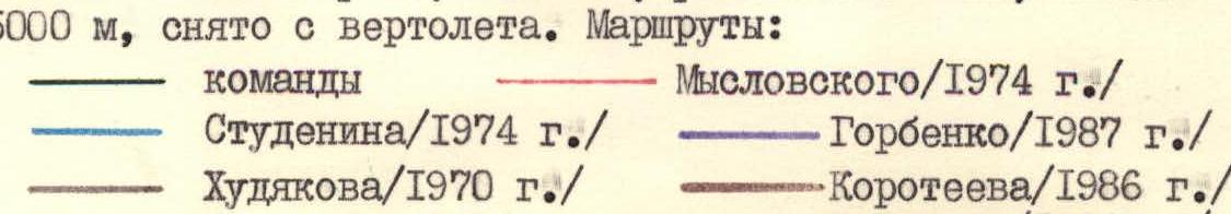
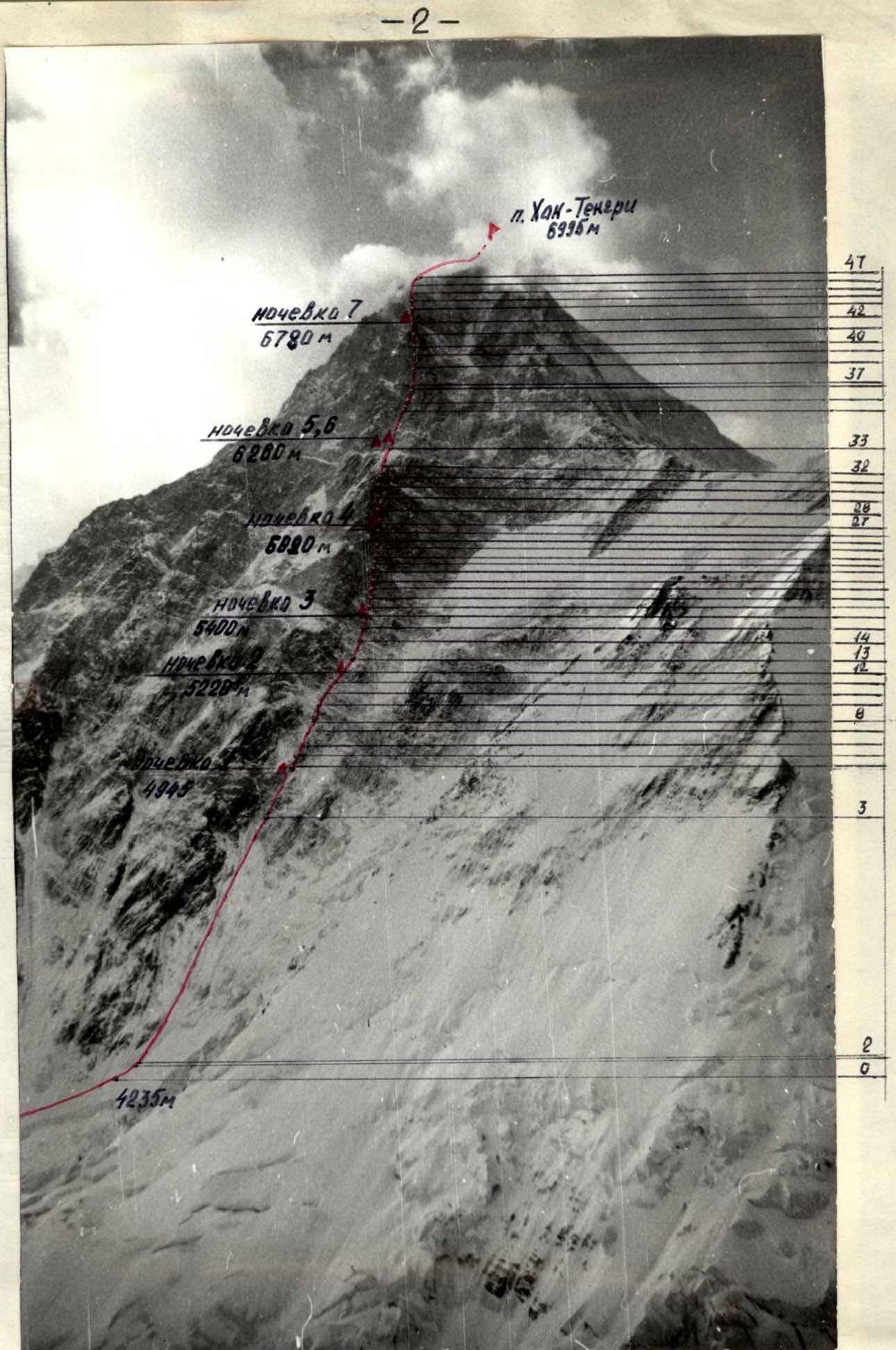
Photo of the route from the right. Taken on August 24, 1988, from a helicopter at 9:00. "Minitar-1" lens, F=32 mm, distance 4.5 km, height 5000 m.
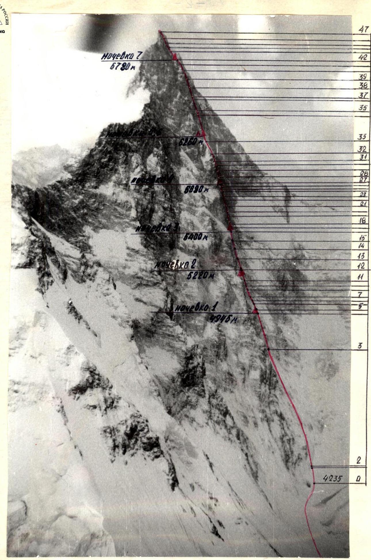
Photo of the route from the left. Taken on August 24, 1988, from a helicopter at 9:10. "Minitar-1" lens, F=32 mm, distance 3 km, height 5000 m.
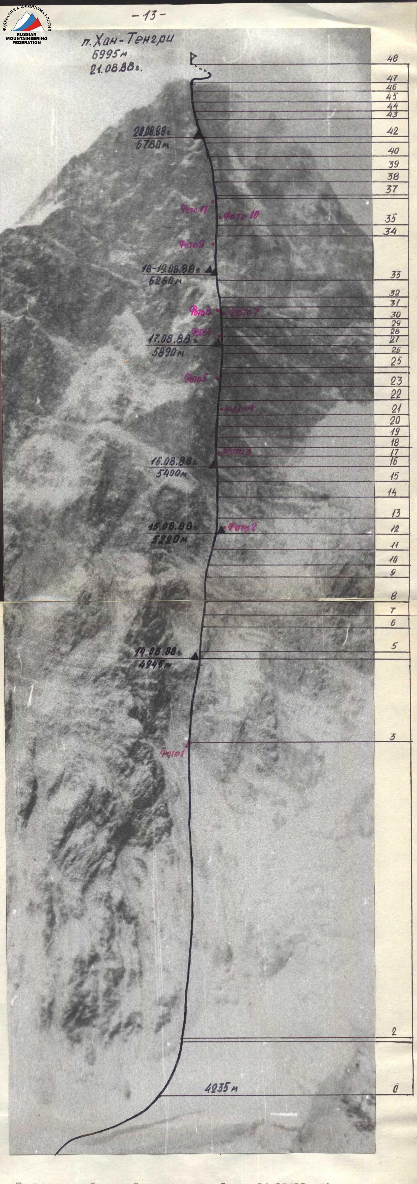
Route Profile
M 1 : 10000
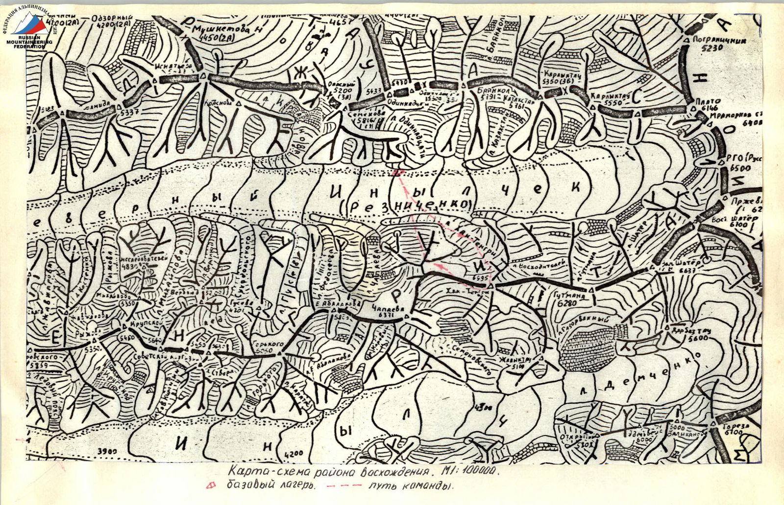
Tactical actions of the team.
The route of the first ascent up the north face of Peak Khan-Tengri was completed from August 14 to August 21. The route followed the planned tactical plan without deviations. It was planned to complete the route in 6 days with good weather, and two reserve days were planned in case of bad weather. One day was used on August 15, when heavy snowfall started at 10:20, reducing visibility to 40–50 m. In these conditions, an overnight stay was organized below the planned R12–R13 section. The second reserve day was used on August 19. On this day, the team "sheltered" as there was heavy snowfall from 18:00 on August 18 to 16:00 on August 19, with visibility of 30–40 m, making it impossible to continue movement due to the risk of avalanches. Overnight stays R1, R3, R4, R5, R6, R7 were organized at planned locations. The change in the R2 overnight location was due to objective reasons — severe weather.
The rotation of leading pairs by day was as follows (the leader in the pair is listed first):
- August 14 — Yarovikov, Bogdanov;
- August 15 — Karlov, Bakaleinikov;
- August 16 — Bakaleinikov, Sereda;
- August 17 — Lebedev, Zakharov;
- August 18 — Antipin, Sereda; processing — Bogdanov;
- August 20 — Zakharov, Yarovikov;
- August 21 — Sereda, Lebedev.
Throughout the route, teamwork was applied — organization of fixed ropes, except for sections R1–R2 and R47–R48 where they moved simultaneously. The lead climber used a double UIAA rope, Ø 9 mm, while the second climber moved on fixed ropes with top-rope protection and carried an Ø 11 mm rope, which was fixed as a handline for the team. The last climber in the team always used top-rope protection, and on sections R14–R15, R16–R32, R34–R41, top-rope protection was used for all participants. For protecting the first climber, a Sticht plate was used. Belay points were set up on 3–4 anchors. Blocking of anchors was done using custom-made loops, freeing the main rope for further work. The work mode for participants: the lead climber worked first for a full day, then was placed in the middle of the group, and then worked last for a day. On the route, all eight participants worked as lead climbers.
The team faced the greatest difficulties on the following sections: R4–R12. In bad weather, movement was complicated by heavy snow cover and icy rocks. Ice climbing equipment was used: crampons, ice axes, ice hammers, and for protection — ice screws. R14–R32. "Black wall". Climbing was very difficult. The average steepness of this section was about 70°. Sections R24–R25, R28–R29 were climbed with the aid of artificial aids. The passage was complicated by the crumbling nature of the rocks. All participants climbed on fixed ropes with top-rope protection. Section R34–R41. "Big chimney". After bad weather, the rocks were covered with snow, and cracks were filled with ice, making it difficult to find places to set up protection.
Food organization: hot breakfast from 7:30 to 8:00; hot dinner from 20:00 to 21:00; during the day, participants ate from individual packs, with rations prepared in advance according to their preferences.
For the north face of Peak Khan-Tengri, special equipment was manufactured:
- 2 double tents weighing 2.1 kg each;
- hammocks suspended on 3 points, used for setting up tent platforms;
- shortened ice screws for wet ice;
- down clothing;
- double boots made to order.
In bad weather, the team acted cohesively and in coordination, with their actions guided by the following objectives:
- ensuring maximum safety during movement on the route;
- organizing safe and comfortable overnight stays with full rest and nutrition;
- ensuring precise passage along the planned route.
Communication with observers was carried out three times a day. A rescue team was stationed at the base camp. Observers were equipped with:
- binoculars;
- 60x telescope;
- a team altimeter.
There were no falls or injuries during the ascent. The route was completed reliably, with a reserve of physical strength, and with technical and tactical competence. On the descent via the "classic" route, the team cleaned up the overnight platforms at 6700 m and 6400 m, packing and bringing down the trash.
Table of food and fuel:
| 1. Rusks | 4 kg | 11. Sausage | 3 kg |
|---|---|---|---|
| 2. Roasted meat | 2 kg | 12. Sports drink | 1 kg |
| 3. Buckwheat groats | 1 kg | 13. Crackers | 1 kg |
| 4. Semolina groats | 0.5 kg | 14. Salmon caviar | 2.5 kg |
| 5. Oatmeal groats | 0.5 kg | 15. Dry milk | 2.0 kg |
| 6. Soups, 16 packs | 1.6 kg | 16. Raisins | 1.0 kg |
| 7. Sugar | 3 kg | 17. Dried apricots | 1.0 kg |
| 8. Candies | 2 kg | 18. Prunes | 1.0 kg |
| 9. Tea | 0.2 kg | 19. Honey | 1.7 kg |
| 10. Lard | 2.0 kg | 20. Walnuts | 1.0 kg |
Total weight of food: 32 kg. Gasoline: 10 l, 9 kg. Total: 41 kg. The weight of backpacks when the team started the route was about 12 kg each, excluding equipment in use.
Description of the route by sections
- Section R1–R2. Bergschrund wall. Steep hard ice, climbed using "ice axes".
- Section R2–R3. Ice slope. Passage is complicated by the presence of a fragile snow crust. Recommended to be climbed before 13:00.
- Section R3–R4. The route passes through internal corners filled with wet ice. Ice climbing equipment is used, including short ice screws.
- Section R4–R5. At the start of the section, on a ledge covered with ice, is a bivouac site. From the bivouac upwards, a complex chimney is climbed using large "offset" protection. The chimney is crumbling, and there is a risk of falling rocks from under the rope, so when climbing the first, the team gathered on a safe ledge to the left.
- Section R5–R6. A large slab covered with wet ice is climbed upwards to the right towards a snow ridge. Cracks are filled with ice, and thin pitons are used for protection.
- Sections R6–R8. Snow ridge leading into the middle part of a snow-filled couloir. The couloir is crossed towards a steep black wall. Protection is mainly through short ice screws.
- Section R8–R9. Steep rock wall. The rock is fragile. The wall is climbed on the left part.
- Sections R9–R11. A series of walls and slabs. Protection is mainly through pitons.
- Section R11–R12. A rocky couloir filled with wet ice is climbed along the left wall of the couloir. The couloir leads to an ice ridge where the second bivouac is set up.
- Section R12–R13. From the bivouac, traverse right and upwards under a rocky overhang to a snow- and ice-filled chimney, then up to a rocky ledge.
- Section R13–R14. At the start of the section, a slab is climbed, followed by ice-covered "ram's foreheads". Cracks for piton placement are filled with snow. The section ends under a steep 50-meter wall — the "yellow belt" — crossing the entire right part of the North face.
- Section R14–R15. "Yellow belt". Climbed 40 m to the left of a chimney crossing the belt. The rocks are monolithic; thin pitons and "stopper" protection are used.
- Section R15–R16. An icy couloir is climbed. After the couloir, traverse left onto flattening rocks where tents are set up for the third bivouac. From the bivouac starts the steepest part of the route — the "black wall".
- Section R16–R17. From the bivouac, traverse right under the wall, then upwards using cracks and flakes for climbing. A belay point is set up on a small ledge under an overhang.
- Section R17–R18. A crumbling wall; finding cracks for protection is difficult.
- Sections R18–R20. Wide cracks are climbed using free climbing. Large-sized "nuts" are used for protection.
- Section R20–R21. A crumbling wall leads to a rocky ridge, from which the path goes left under a steep, snow-covered "ram's foreheads" (sections R21–R22).
- Section R22–R23. A steep internal corner with a split. The walls of the corner are smooth. The belay points are hanging.
- Section R23–R24. A wall with unstable blocks is climbed in the center along a barely visible counterfort.
- Section R24–R25. A crack; the rock is fragile. Climbing is done using artificial aids.
- Section R25–R26. Traverse left along a snow-covered slab under an internal corner.
- Section R26–R27. Traverse right under an overhang. In the internal corner and the lower part of the overhang, a wide crack is used for free climbing. The section leads to an inclined ledge where the fourth bivouac is set up.
- Section R27–R28. A crumbling wall; the rock is fragile, with loose stones on the ledges.
- Section R28–R29. At the start, a steep smooth wall with minimal holds is climbed, followed by a flake with a crack; climbing is difficult.
- Section R29–R30. The section starts on a large ledge, on the left part. The climb initially goes upwards along a 10 m wall, then right and upwards along smooth outcrops to a small ledge where a belay point is set up.
- Section R30–R31. A series of internal corners is climbed. "Nuts" and "stopper" protection are mainly used.
- Section R31–R32. The path goes along the left part of a smooth rocky couloir, bypassing an overhang. There are few cracks for protection; large "offset" protection is sought under the overhang. The section leads to the upper part of the "black wall".
- Section R32–R33. A ridge, initially rocky and very crumbling, then snowy. Movement along the ridge is directed towards a small rocky outcrop under the base of the rust-colored rocks.
- Section R33–R34. A series of snow-covered "ram's foreheads", walls, and wet ice gullies is climbed. The direction is from the rocky outcrop to the base of a large chimney. At 40 and 60 m from the start of the section, inclined ledges are used for bivouac sites.
- Section R34–R35. The start of a large chimney. An internal corner with very crumbling walls is climbed. The corner ends in an overhang, which is climbed directly.
- Section R35–R36. Initially, an internal corner with a wide crack is climbed, followed by a chimney, which is climbed using "bridging".
- Section R36–R37. A snow ridge dividing the large chimney into two parts is climbed.
- Section R37–R38. Traverse a monolithic wall with an exit into an internal corner. Thin pitons are mainly used.
- Section R38–R39. An icy internal corner is climbed. The upper part of the corner is very crumbling and is bypassed on the wall to the left.
- Section R39–R40. A chimney with smooth walls and cracks filled with ice is climbed.
- Section R40–R41. An internal corner with an overhang in the upper part is climbed. Many "loose stones" are present.
- Section R41–R42. A rocky rib with an overhang in the middle part is climbed. On the ledges, there are loose stones that can be dislodged by the rope, so the belay point is set up under the overhanging wall at the start of the rib.
- Section R42–R43. A snowy rocky ridge consisting of separate frozen blocks and slabs is climbed. At the start of the ridge, a ledge is used to set up bivouac platforms made of stones.
- Section R43–R44. A monolithic wall covered with wet ice is climbed vertically.
- Sections R44–R46. An internal corner turning into a wide chimney is climbed. "Nuts" and "channels" are mainly used for protection.
- Section R46–R47. A rocky rib leads to the summit snow dome.
- Section R47–R48. The summit dome is climbed. Movement initially goes right over rocks for 100 m, then left along the snow to the summit.
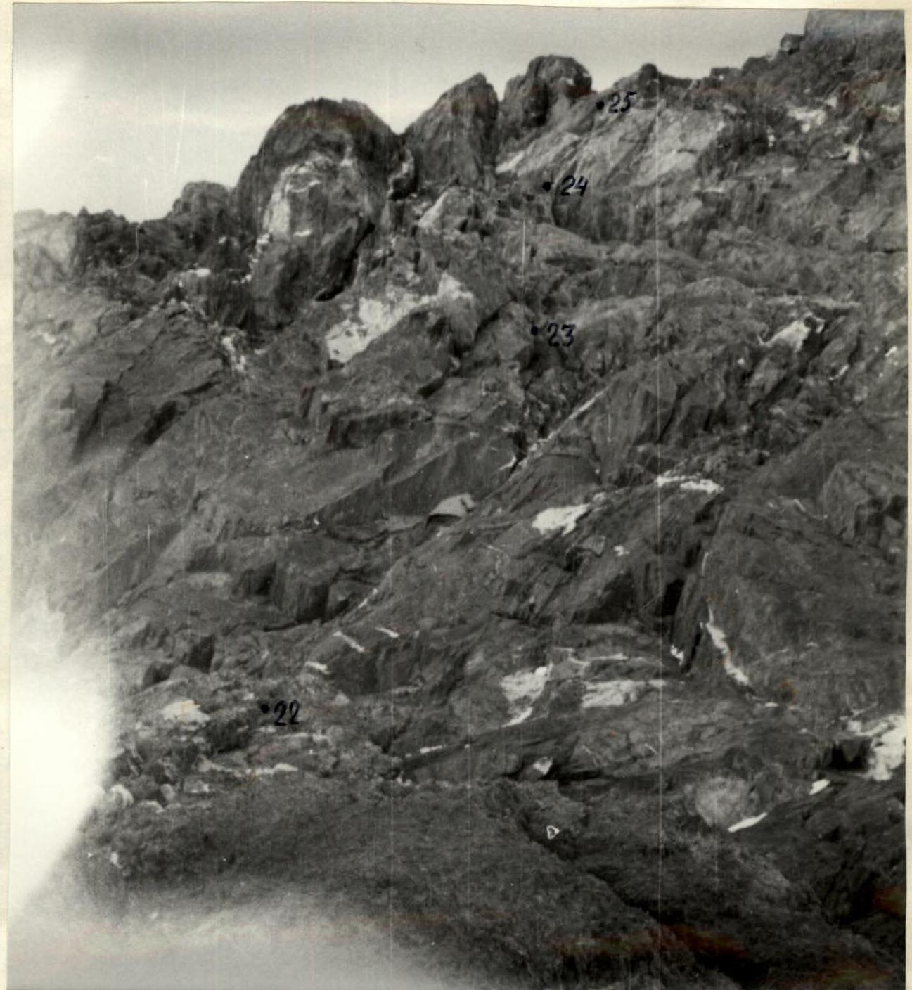
Photo 4. Sections R22–R25. The first climber ascending the internal corner. Taken on August 17, 1988, at 14:50.
Technical photo of the route. Taken on August 24, 1988, at 9:00 from a helicopter. "Minitar-1" lens, F=32 mm, distance 3 km, height 5000 m.
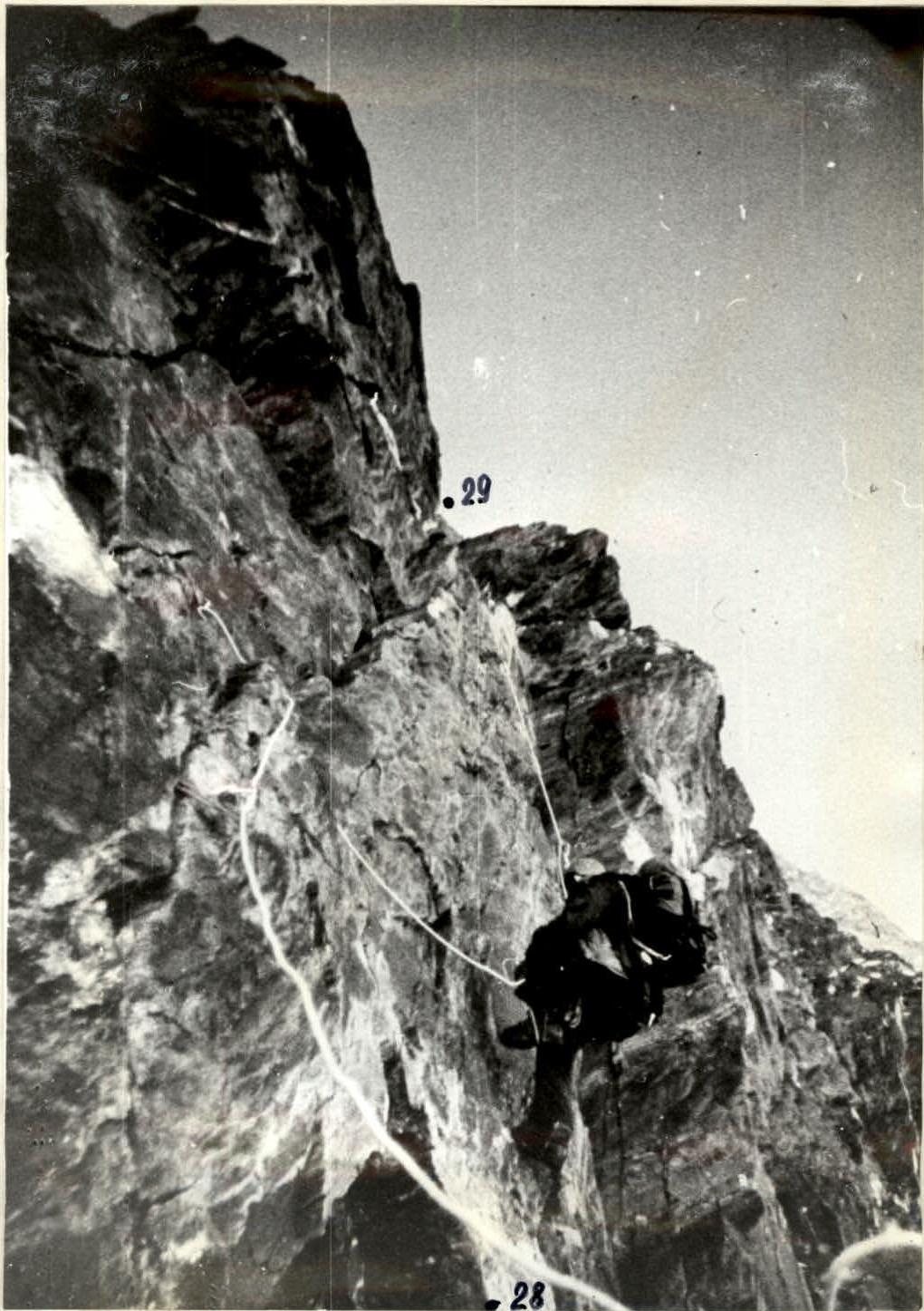
Photo 6. Section R28–R29. Climbers on fixed ropes. Taken on August 18, 1988, at 9:40.
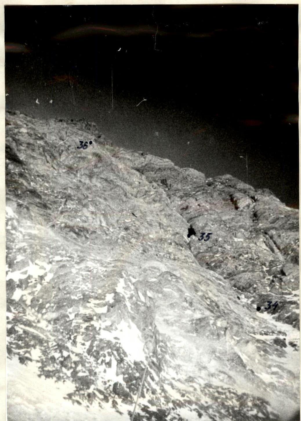
Photo 9. Lower part of the big chimney. Sections R34–R36. Taken on August 20, 1988, at 12:00.
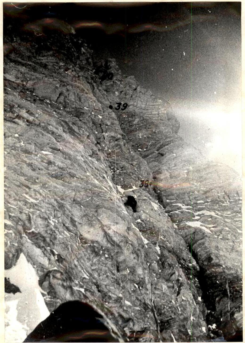
Photo 11. Upper part of the big chimney. Sections R37–R41. The first climber. Taken on August 20, 1988, at 15:20.

Photo 10. Climbers on fixed ropes on section R34–R35. Taken on August 20, 1988, at 12:50.