USSR ALPINISM FEDERATION 1973 USSR ALPINISM CHAMPIONSHIP HIGH-ALTITUDE ASCENT CLASS
Report
on the ascent of Khan-Tengri peak via the SSE ridge with access to the ridge via the counterfort of the eastern wall by the combined team of climbers from the Sports Committee of the Uzbek SSR, Tashkent 1973
1. Brief Geographical Description and Sporting Characteristics
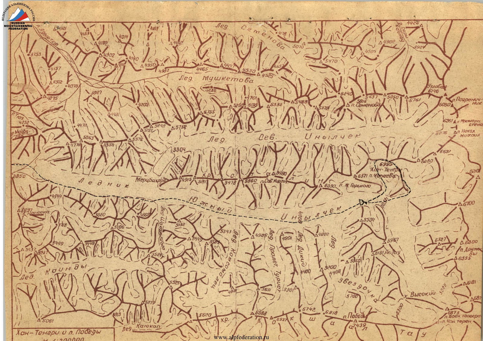
Khan-Tengri peak (6995 m) is the highest point of the Tengri-Tag ridge, one of the highest in Tian Shan. The Tengri-Tag ridge, located in the upper reaches of the Inylchek River, a left tributary of the Sarydzhas River (Tarim basin), starts in the east from the Meridionalny ridge in the area of Shaater peak, and in the west it ends at the confluence of the largest Tian Shan glaciers: the Southern (59.4 km²) and Northern (35 km) Inylcheks, near Bronenosets peak. The ridge is about 40 km long and about 8 km wide. The ridge has an asymmetrical structure (its watershed is strongly shifted to the south). The snow line on the southern slopes fluctuates at around 4500 m.
In the eastern part of the ridge, 10 km from its junction with the Meridionalny ridge, Khan-Tengri peak rises, a strikingly beautiful, perfect, and architecturally light summit, long considered the highest point of Tian Shan.
The first information about the peak was published by an Italian expedition in 1904–1905. The Munich researcher Merczbacher made a significant contribution to the study of the area. However, it was not until 1930 that the expedition led by Pogrebetsky M.T. reached the foot of the peak, and on September 11, 1931, Pogrebetsky's group conquered the seemingly impregnable summit via the route now known as the "classic" route.
In 1936, two groups reached the summit: E. Kolokolnikov on August 24 and E. Abalakov on September 5. After a long break, the peak was conquered again in 1954 by a group of Kazakh climbers led by Shipilov V.
In recent years, the peak, which has gained immense popularity and become a cherished goal for many climbers worldwide, has attracted more and more sports groups attempting new, increasingly complex routes: 1962 - Maryashev V.'s group 1964 - Romanov B., Kuzmin K., Voroshilov's group 1968 - Studenin B.'s group via two routes, including a traverse from Shaater peak 1969 - Golodov's group 1970 - Karasev's and Khudyakov O.'s groups 1971 - Putrin V., Ilinsky E., Alibekdashvili L.'s groups 1972 - Myslovsky E. and Putrin V.'s groups The potential of the peak is far from exhausted, with several excellent routes available from both the northern and southern sides.
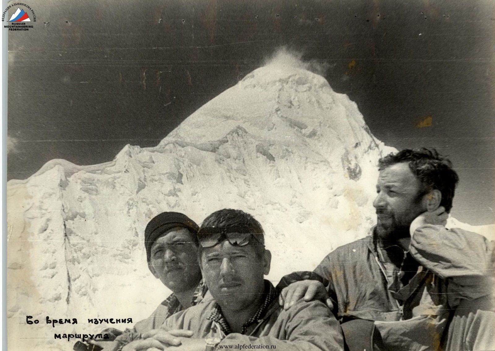 During route reconnaissance
Organizational and Tactical Plan
The organizational plan and schedule for the expedition were developed in advance. Unfortunately, it was not possible to follow it due to the absence of a helicopter.
On July 10, 1973, the entire expedition team arrived at the Inylchek outpost in two vehicles. By the end of July, it became clear that if a helicopter was to be used, it would only be able to drop off cargo at the base camp. A group consisting of Lukin V.N. (leader), Bukhalov V.S., Sergeev N.Ya., and Shugaev S.D. headed to the glacier to meet the cargo.
Due to the delayed decision on the helicopter, another group, led by Kalinin G.V., and including Tkachenko A.N., Shingalov A.A., and Filyushkin V.V., set out to the glacier to supply the first group with food.
On August 2, 1973, a helicopter began operating, dropping cargo at the base camp and landing people at Chon-Tash near the tongue of the Inylchek glacier.
On August 8, 1973, almost a month behind schedule, the entire expedition team assembled at the base camp under the slopes of Khan-Tengri peak on the medial moraine of the Inylchek glacier. Due to the significant delay, it was decided to focus solely on the main task - ascending Khan-Tengri peak via the SSE ridge with access to the ridge via the counterfort of the eastern wall.
Taking into account the adjustments made due to objective organizational circumstances, the following tactical plan for the ascent was developed:
- August 10, 1973 - The assault group sets out in full composition with all gear.
- August 11, 1973 - Thorough examination of the route's condition.
- August 12, 1973 - Five team members begin processing the route, while the remaining five continue to study and monitor the group processing the route.
- August 13, 1973 - Rest day. Final preparations for the ascent. A group from the base camp approaches to observe the team until it reaches the ridge.
- August 14, 1973 - Ascent onto the route.
- August 15-16, 1973 - Passage through the counterfort.
- August 17, 1973 - Processing of the cornice.
- August 18, 1973 - Passage through the cornice.
- August 19, 1973 - Processing of the corniced ridge.
- August 20, 1973 - Ascent to the "marble rib".
- August 21, 1973 - Passage through the "marble rib".
- August 22-23, 1973 - Processing of the icefall.
- August 24, 1973 - Passage through the icefall and ascent as high as possible beyond it.
- August 25, 1973 - Ascent to the summit and commencement of descent to the saddle between Khan-Tengri and Chapayeva peaks.
- August 26, 1973 - Descent to the base camp.
- August 27-30, 1973 - Reserve for bad weather.
Due to the high technical complexity of the route, daily altitude gains were expected to be relatively small (averaging 200-250 m).
To facilitate the work of the lead climber, the team brought: two nylon ropes, eight 12mm ropes to provide reliable belays for the rest of the team, and two cordelettes. For navigating vertical and negative sections, climbing jammers were used.
The "hardware" was selected considering the challenging ice conditions on the route: long and short screwdrivers, ice screws, and a wide range of rock pitons, as well as profiled snow stakes and titanium avalanche shovels for snowy and firn sections. On complex sections, it was planned to pull up backpacks using two block-brake devices.
Given the lack of obvious safe areas for overnight stays on the route, the tactical plan allowed for using the time to create them to process the next section of the route.
The lower part of the route was snow-free, allowing the team to start in high-altitude footwear without worrying about getting it wet. The high-altitude footwear consisted of well-padded valenki boots with titanium crampons, and canvas covers with zippers were made to facilitate drying the boots at bivouacs.
The adopted ascent tactics proved to be entirely justified. Minor adjustments were made to the movement schedule during the route.
Until August 16, 1973, the route progressed according to plan. On August 17, 1973, the cornice on the main ridge was passed without additional processing. On August 18-19, 1973, the team progressed according to plan, with a one-day lead. On August 20-21, 1973, due to the onset of bad weather, the passage through the "marble rib" took two days. On August 22-25, 1973, due to continued bad weather and greater-than-expected technical complexity of the icefall, its passage took four days. On August 26, 1973, at 16:20, the group reached the summit. The descent proceeded according to plan via the classic route.
The long screwdrivers, ice screws, profiled snow stakes, and titanium shovels with cables adapted for belaying performed exceptionally well on the route.
The use of double ropes by the lead climber also proved to be entirely justified, given the large number of pitons hammered into the route. The quantity of ropes taken to the route allowed for reliable and uninterrupted work.
Composition of the Assault and Observation Groups
According to the application, the assault team was determined as follows:
- Voronin V.T. - captain
- Luman Z. - deputy captain
- Bloshtein B.E.
- Gromov L.V.
- Lukin V.N.
- Lyabin A.P.
- Putintsev A.V.
- Fink V.A.
- Kharechko N.G.
- Yakhin Kh.
The entire team that participated in the previous year's reconnaissance attempt has been climbing together for many years, with a wealth of joint ascents of the highest categories. They are physically, technically, and tactically well-prepared.
Due to changes in the organizational plans of the expedition, the observation group included the rest of the expedition team, totaling 14 people, led by the expedition leader and team coach, Honored Coach of the Uzbek SSR Elchibekov V.A.
To ensure observation of the team until it reached the main ridge, a group consisting of Kalinin G.V. (leader), Sergeev N.Ya., Shugaev S.D., and Filyushkin E.V. was sent to the Razorvanny glacier.
The observation group maintained constant visual contact with the assault team and also conducted daily radio checks at 9:00, 12:00, 15:00, 18:00, and 21:00 using the "Nedra-P" radio station, which operated flawlessly. The group's tasks also included maintaining communication with neighboring expeditions and providing assistance to the climbers if needed.
The tasks assigned to Kalinin G.V.'s group were:
- To observe the assault team until it reached the main ridge.
- To dismantle the assault camp on the Razorvanny glacier.
- To meet the assault team on its descent on the Semenovsky glacier.
The observation group successfully completed all assigned tasks.
Route Passage Details
After additional thorough examination and observation of the route, it became clear that the lower part of the route needed to be traversed before sunrise due to the risk of small avalanches from fresh snow (the hazardous zone is indicated by a dashed line on the photograph).
It was decided to start the ascent no later than 3:00 AM. The path through the glacier under the route was previously identified and marked.
On August 12, 1973, Lyabin A., Lukin V., Gromov L., Yakhin Kh., and Fink V. ascended from the glacier via the avalanche cone (section R0-R1), through the bergschrund filled with snow, onto the ice slope (section R1-R2), which was heavily smoothed by avalanches. The ice slope led to the first rocky outcrop (section R2-R3), where the rocks were heavily smoothed, and all cracks and ledges were filled with avalanched snow, making progress extremely difficult.
The rocks flattened out and led to another ice slope (section R3-R4), also smoothed by avalanches, followed by another rocky outcrop (section R4-R5), which was more pronounced and safer. The heavily destroyed rocks, filled with ice (section R4-R5), ended in an ice ledge.
Immediately behind the ledge, a нависающая стена (overhanging wall) (section R5-R6) rose, filled with vascular ice and bounded on both sides by couloirs, where small avalanches were triggered by the onset of bad weather. The wall was ascended head-on, starting from the upper point of the ledge. Gradually, the rocks flattened out (section R6-R7) and led to the next ice ledge.
Having securely fixed the ropes, the five-person team quickly descended.
On August 14, 1973, the team quickly progressed through the processed part of the route using jammers and pulled up their backpacks on the section R5-R6.
As they ascended the heavily destroyed rocks (section R7-R8), filled with flowstone and vascular ice on two cornices crossing the route, Putintsev led the way. The rocks ended in an ice ascent (section R8-R9).
A weakly held layer of porous half-ice, half-firn lay on the main ice mass, making progress extremely difficult: crampons were clogged and did not hold, and to cut steps or hammer in a piton, it was necessary to remove the entire top layer. This ice structure persisted throughout the counterfort.
The ascent led to an ice drop (section R9-R10), which dropped off to the right side of the counterfort. To the left, the drop narrowed, and after driving in a couple of anchor pitons, Luman continued upward, simply cutting steps.
Having spent an hour and a half, the team expanded the ledge to a reasonable size, and the pair continued further processing.
By traversing left around the нависающий сброс (overhanging drop) (section R10-R11) via a steep ice slope, they reached rocks of a similar character to the previous ones, beginning with a wall (section R11-R12). A control cairn marked the exit to the next section. The rocks gradually narrowed and continued as a narrow strip (section R12-R13), bounded by steep ice walls. Almost in the dark, the pair descended to their overnight stay.
The detailed description of the route continues in a similar manner, detailing the team's progress, challenges, and conditions faced on each section of the ascent.
Table of Key Route Characteristics
Ascent route: SSE ridge with access to the ridge via the counterfort of the eastern wall. Route elevation gain: 2300 m. Including the most challenging sections: 800 m. Route steepness: 50°. Counterfort steepness: 70°.
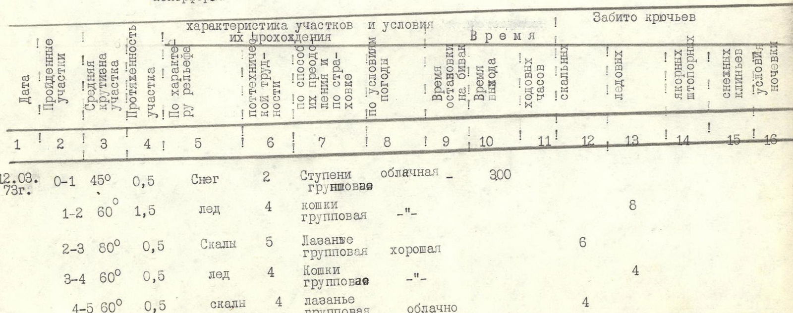
| Date | Sections Covered | Average Steepness of Section | Length of Section | Terrain Characteristics | Category of Difficulty | Methods of Overcoming and Belaying | Weather Conditions | Time of Biwak | Time of Departure | Climbing Hours | Rock Pitons | Ice Pitons | Anchor/Ice Screw Pitons | Snow Stakes | Conditions for Overnight Stay |
|---|---|---|---|---|---|---|---|---|---|---|---|---|---|---|---|
| 12.08.1973 | R0–R1 | 45° | 0.5 | Snow | 2 | Steps | Overcast | 3:00 | |||||||
| R1–R2 | 60° | 1.5 | Ice | 4 | Crampons, group | Same | 8 | ||||||||
| R2–R3 | 80° | 0.5 | Rocks | 5 | Group climbing | Good | 6 | ||||||||
| R3–R4 | 60° | 0.5 | Ice | 4 | Crampons, group | Same | 4 | ||||||||
| R4–R5 | 60° | 0.5 | Rocks | 4 | Group climbing | Overcast | 4 | ||||||||
| 14.08.1973 | R5–R6 | 95° | 0.5 | Rocks | 6 | Jammers, stirrups | Snow, fog | 12 | |||||||
| R6–R7 | 70° | 1.5 | Rocks | 5 | Group climbing | Same | |||||||||
| R7–R8 | 80° | 1 | Rocks | 5 | Group climbing | Fog, wind | 18:30 | 15:30 | 3:00 | 11 | 9 | ||||
| R8–R9 | 65° | 2 | Ice | 4 | Group step-cutting | Fog, snow, wind | 11 | ||||||||
| R9–R10 | 75° | 2.5 | Ice | 5 | Group step-cutting | Same | 14 | 2 | Semi-reclining | ||||||
| R10–R11 | 65° | 1.5 | Ice | 4 | Group step-cutting | Same | 9 | ||||||||
| R11–R12 | 85° | 0.25 | Ice | 6 | Group climbing | Same | 5 | ||||||||
| R12–R13 | 75° | 3 | Rocks | 5 | Group climbing | Same | 21:00 | 18:00 | 1:00 | 28 | |||||
| 15.08.1973 | R13–R14 | 70° | 2.5 | Ice | 5 | Group step-cutting | Fog | 9:00 | 13 | ||||||
| R14–R15 | 80° | 1 | Ice, rocks | 5 | Step-cutting, climbing | Same | 4 | 6 | |||||||
| R15–R16 | 70° | 0.5 | Ice, firn | 6 | Cornice removal, group step-cutting | Fog, wind | 4 | 3 | Semi-sitting | ||||||
| 16.08.1973 | R16–R17 | 70° | 1 | Ice, firn | 6 | Cornice removal, group step-cutting | Fog, wind | 20:00 | 11:00 | 11:00 | 11 | 5 | |||
| R17–R18 | 70° | 4.5 | Ice, firn | 6 | Same | Initially clear, then fog, snow, wind | 9:00 | 43 | 9 | Lying | |||||
| R18–R19 | 70°/20° | 2.5 | Ice, snow | 3 | Group steps | Fog, snow, wind | 4 | 2 | |||||||
| R19–R20 | 75° | 2 | Ice | 5 | Group step-cutting | Same | 21:30 | 12:30 | 12 | ||||||
| 17.08.1973 | R20–R21 | 90°/45° | 0.5 | Firn | 6 | Artificial handholds, group trench-cutting | Clear | 9:00 | 17 | ||||||
| R21–R22 | 50° | 2.5 | Firn | 3 | Crampons, group | Wind | 4 | ||||||||
| R22–R23 | 0°/20° | 8.0 | Snow | 1 | Simultaneous | Wind | 18:30 | 8:30 | Lying | ||||||
| 18.08.1973 | R23–R24 | 45° | 3.5 | Firn, ice | 4 | Crampons, group | Clear | 9:30 | 16 | ||||||
| R24–R25 | 0°/80° | 1 | Firn, ice | 5 | Crampons, group | Wind | 5 | ||||||||
| R25–R26 | 90° | 0.5 | Ice, firn | 6 | Stirrups, group cornice removal | Wind | 3 | 6 | 14 | ||||||
| R26–R27 | 0°/75° | 3 | Ice, firn | 5 | Crampons, group | Wind | 19:00 | 9:30 | 18 | ||||||
| 19.08.1973 | R27–R28 | 45° | 3 | Snow | 2 | Simultaneous | Fog, snow, wind | 9:00 | |||||||
| R28–R29 | 0°/40° | 1 | Snow | 2 | Same | Same | |||||||||
| R29–R30 | 50° | 5 | Snow | 2 | Same | Same | |||||||||
| R30–R31 | 0° | 4 | Snow | 1 | Same | Same | 20:30 | 11:30 | Lying | ||||||
| 20.08.1973 | R31–R32 | 50° | 5 | Snow | 3 | Alternating | Same | 15:30 | 11:00 | 4:30 | Semi-reclining | ||||
| 21.08.1973 | R32–R33 | 50° | 10 | Snow, rocks | 4 | Group climbing | Strong wind | 17:30 | 10:00 | 7:30 | 18 | ||||
| 22.08.1973 | R33–R34 | 70° | 1.5 | Ice | 5 | Group step-cutting | Fog, snow, hurricane-force wind | 16:00 | 11:00 | 5:00 | 11 | Lying | |||
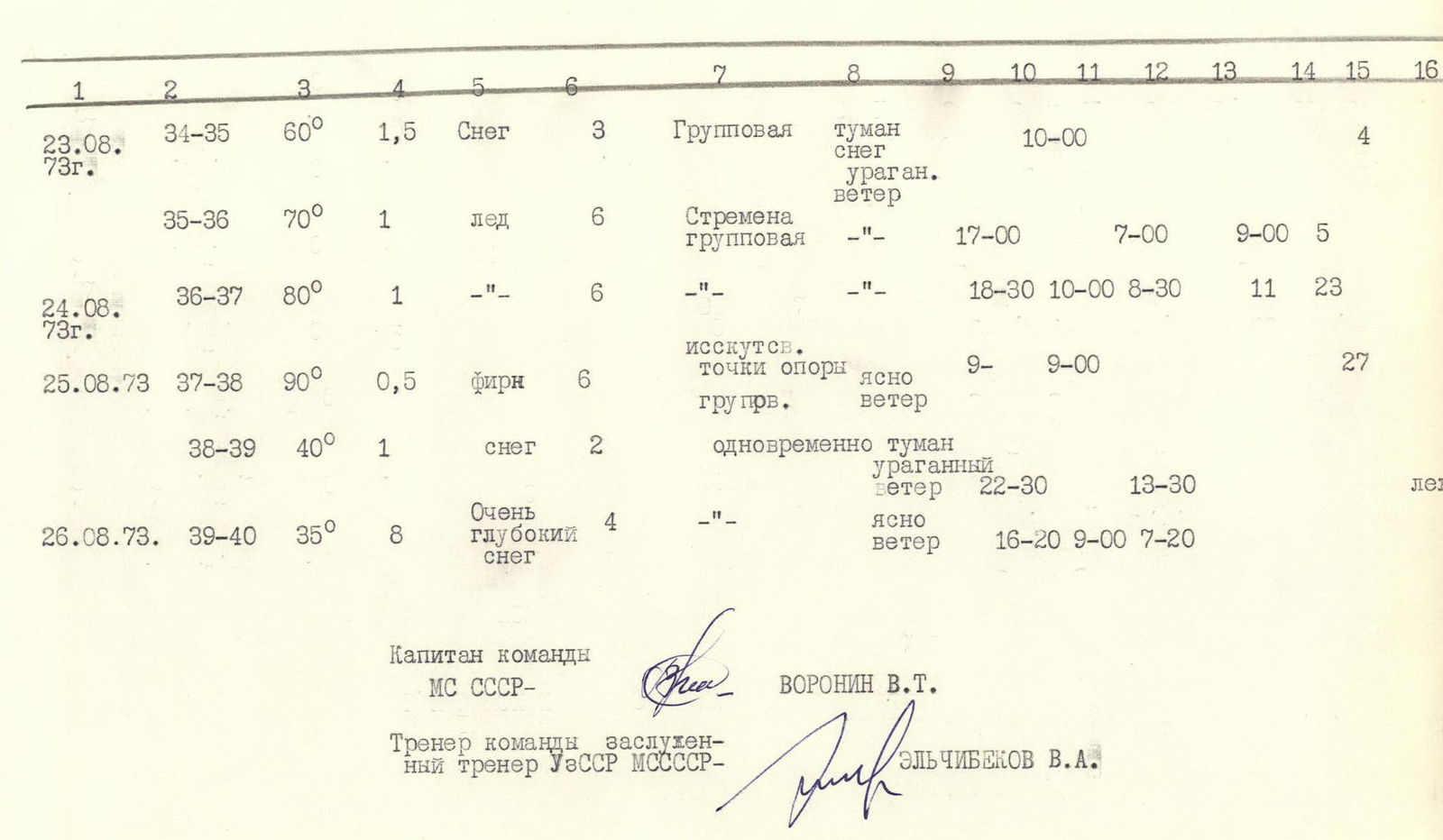
| 23.08.1973 | R34–R35 | 60° | 1.5 | Snow | 3 | Group | Fog, snow, hurricane-force wind | 10:00 | 4 | ||||||
| R35–R36 | 70° | 1 | Ice | 6 | Stirrups, group | Same | 17:00 | 7:00 | 9:00 | 5 | |||||
| 24.08.1973 | R36–R37 | 80° | 1 | Ice | 6 | Same | Same | 18:30 | 10:00 | 8:30 | 11 | 23 | |||
| 25.08.1973 | R37–R38 | 90° | 0.5 | Firn | 6 | Artificial handholds, group | Clear, wind | 9:00 | 27 | ||||||
| R38–R39 | 40° | 1 | Snow | 2 | Simultaneous | Fog, hurricane-force wind | 22:30 | 13:30 | Light | ||||||
| 26.08.1973 | R39–R40 | 35° | 8 | Very deep snow | 4 | Same | Clear, wind | 16:20 | 9:00 | 7:20 |
Overall Assessment of the Participants' Actions
Despite the significant disruption to the organizational plans of the expedition, which kept everyone in a state of constant nervous tension due to the threat of the entire expedition being canceled, all participants in the assault maintained a high level of motivation to reach the summit. Moreover, the compressed timeline mobilized not only the assault group but also the entire expedition team to work even more cohesively and proactively during the final preparations for the assault, which enabled them to start the ascent just a day after being dropped off at the glacier.
The entire team had participated in the previous year's reconnaissance attempt, which provided an opportunity for a detailed familiarization with the lower part of the route. Although the heavy ice conditions this year and changes in the configuration of the cornices almost completely altered the technique and tactics of the ascent, and in some places even the route.
The team members are a well-established collective with excellent physical, technical, and tactical preparation. They have a large number of joint ascents of the highest categories to their credit. All this allowed them to develop a correct tactical plan, successfully complete the ascent, working with full dedication, mutual understanding, and support.
Team captain, Master of Sports of the USSR - Voronin V.T. Team coach, Honored Coach of the Uzbek SSR, Master of Sports of the USSR - Elchibekov V.A.
Additional Information
This year, the route presented very challenging ice conditions. In more snowy years, more specialized snow equipment may be required for its passage. It is necessary to consider that the configuration of the corniced part of the route changes annually, as does the condition of the icefall on the summit cap. We reiterate the importance of traversing the lower part of the route with caution due to potential avalanche hazards.
The team members, who have to their credit such technically complex ascents as Engels (6th category of difficulty), Bodhon (6th category of difficulty), numerous routes of the 5th category, and high-altitude ascents like Lenin Peak via almost all routes, Peak Korzhenevskaya, Peak of the Revolution, Peak of the Communist Academy, Peak Victory, and Peak Communism via two routes, among others, consider the route significantly more challenging than all previously ascended routes and belonging to the highest category of difficulty.
On behalf of the team:
 (Voronin V.T.) (Bloshtein B.E.) (Putintsev A.V.)
Processing
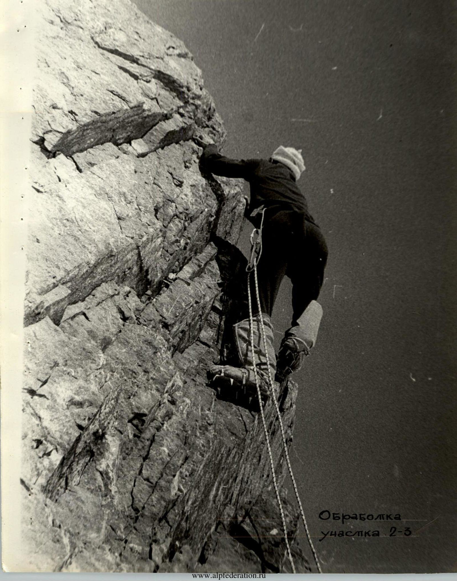 Processing of section R2–R3
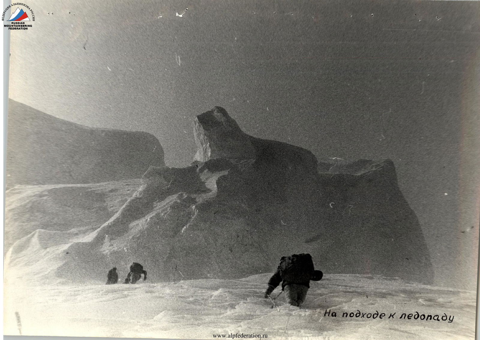 Approaching the icefall