Climbing Report for the USSR Alpine Climbing Championship
-
Climbing category — High-altitude.
-
Climbing area — North Inylchek Glacier, Central Tien Shan.
-
Climbing route — North slope of Khan-Tengri 6995 m, Kuzmin's route, 6B category of difficulty.
-
Climbing characteristics:
- Elevation gain — 3000 m
- Average slope approximately 50°
- Length of most challenging sections — 1300 m
-
Pitons used:
- Rock pitons — 82
- Ice pitons — 39
- Bolts — none.
-
Time taken to reach the summit — 42 hours.
-
Number of bivouacs and their characteristics:
- 4 lying-down bivouacs.
-
Team name — Kazakh Alpine Club.
-
Participant names and positions:
- Coach and team captain — Ilyinsky Ervand Tikhonovich, Master of Sports of the USSR.
- Participants: Golodov Yuri Fedorovich, Master of Sports of the USSR Kondrashov Igor Vasilyevich, Candidate Master of Sports of the USSR Klekovkin Vladimir Fedorovich — ditto — Repin Evgeny Ivanovich — ditto — Khrebtov Nikolai Petrovich — ditto — Ivanov Nikolai Petrovich — ditto — Chepchev Sergey Georgievich — ditto — Smirnov Vadim Anatolyevich — ditto —
-
Climbing date: August 25, 1971.
-
Team's final position —
6995
08/27/71
Khan-Tengri (view from Peak Marmor Marble Wall)
"Behold, Khan-Tengri — the Lord of the Sky!"
(M.T. Pogrebetsky)
Historical Background
Starting from 1856, one scientific expedition after another ventured into the depths of Tien Shan. Notable visitors included:
- Prominent geographer P.P. Semenov-Tian-Shansky
- Mining engineer I.V. Ignatyev
- Hungarian zoologists Georg Almani and Stummer Traunfels.
The first attempts to reach the Khan-Tengri peak area date back to 1900 when a group of Italian climbers led by Cesare Bargese entered the Inylchek valley and realized the extreme difficulty of the route.
In 1902, an expedition led by geographer and renowned alpinist Dr. Gottfried Merzbacher arrived in Tien Shan. To gain orographic orientation, he conducted several ascents and was the first to reach the foot of Khan-Tengri, determining its exact location. Merzbacher later wrote: "The peaks of Tien Shan are unsuitable for alpine pursuits."
Only during the Soviet era did the conquest of Central Tien Shan truly begin.
Moscow climbers first reached the upper reaches of the North Inylchek Glacier in 1931 under the leadership of Sukhodolsky, attempting an unsuccessful ascent of Khan-Tengri from the north. Since then, the North Inylchek Glacier remained uncharted territory for climbers until 1964. The first ascent of Khan-Tengri was achieved by a Ukrainian expedition team led by M.T. Pogrebetsky in 1931, via the South Inylchek Glacier along the SW ridge.
In 1936, two groups reached the summit of Khan-Tengri:
- A Kazakh team led by E.M. Kolokolnikov
- A sports team from the I All-Union Trade Union Spartakiad led by E.M. Abalakov, a few days later.
In 1954 and 1962, Kazakh climbers (teams led by V.P. Shipilov and A.N. Maryashev) again reached the summit, following the same route.
In subsequent years, climbers focused on previously unattempted and considered inaccessible routes to Khan-Tengri:
- From the south
- Southeast
- North.
In 1964, two teams were dispatched to Central Tien Shan. The "Trud" Sports Society expedition, led by B.T. Romanov, targeted Khan-Tengri from the south, achieving success with a group of six climbers ascending via the Marble Rib (category 6B).
On the North Inylchek Glacier, an expedition from the USSR Academy of Sciences, led by E.I. Tam, was underway. K.K. Kuzmin's group from this expedition successfully ascended Khan-Tengri from the north with a team of five, marking a new route classified as 6B category of difficulty.
In 1968, a combined expedition from the Kazakh Republic "Spartak" and "Burevestnik" sports societies traversed the North Inylchek Glacier via the Karly-Tau pass, adopting a new route. A group led by B.A. Studenin ascended Khan-Tengri twice from the north:
- Ascent from the north via the plateau
- Traverse: Peak Shater — 50 Years of VLKSM — Peak Saladina — Khan-Tengri.
This marked the first traverse ascent of the peak.
In 1969, a group led by Yu.F. Golodov from the Kazakh Republic "Burevestnik" Sports Society ascended Khan-Tengri from the south via the Marble Rib.
In 1970, a "Dynamo" Central Council team ascended the NE counterfort of the North face of Khan-Tengri, category 6B.
The route via Kuzmin's path from the north was of particular interest to our team, representing a challenging yet feasible and prestigious goal.
The North face of Khan-Tengri posed significant interest, with one of the expedition's objectives being to scout this face.
Geography of the Area
Khan-Tengri (6995 m) is situated in the Tengri-Tag range, being the second-highest peak in Central Tien Shan. The range stretches latitudinally, separating the North and South Inylchek glaciers.
Khan-Tengri is the most prominent peak in the range.
The North Inylchek Glacier:
- Relatively gentle and less dissected in its upper part.
- Reaches an elevation of 4000 m above sea level in the vicinity of Khan-Tengri.
The Khan-Tengri glacier is a cirque glacier. The Tengri-Tag range lacks any significant col, attributed to the nature of its constituent rocks. The range features 14 peaks and 57 glaciers, with 21 glaciers on its southern slope. Peaks in the Tengri-Tag are more accessible from the south; ascents from the north are more challenging due to extensive glaciation and snow cover. According to recent unofficial data, the height of Khan-Tengri is 7010 m above sea level.
Climbing Conditions
The remoteness and inaccessibility of the Khan-Tengri area are notable challenges.
The expedition's journey began from Almaty, involving:
- A car journey to Maydanabad settlement (approximately 500 km).
- A helicopter flight (piloted by I. Tselman) to the North Inylchek Glacier.
The base camp was located opposite the intended route, within a 20-30 minute walk.
Access to the upper North Inylchek Glacier is complicated by the need to circumvent Lake Merzbacher, making it a significant challenge. Consequently, only three mountaineering expeditions had reached the North Inylchek Glacier before ours.
In 1968 and 1970, expeditions used the route via the Karly-Tau pass to reach the North Inylchek Glacier, but this route is also complex and requires helicopter support.
Relief
The northern slopes of Khan-Tengri feature significant glaciation. Rock outcrops are composed of sedimentary rocks from two suites. The lower suite includes:
- Carbonaceous-clay shales
- Limestone-clay shales
- Other types of shales.
These contain remnants indicating the presence of life several hundred million years ago.
The upper suite consists of marbleized limestones and marbles. The boundary between the two suites is observable at around 6300-6400 m elevation, particularly on the north face of Khan-Tengri.
The rocks are fragile and unreliable. The north-facing slopes are less accessible than the southern ones. The ice and snow slopes are very steep (average slope more than 50°) with numerous steep ice ledges and active seracs. Large ice blocks frequently break off and slide down.
Only the nearly three-kilometer North face is largely ice-free.
A characteristic feature of ascending Khan-Tengri is that the route's difficulty does not decrease with altitude; it arguably increases.
Meteorological Conditions and Snow Cover
The weather in Central Tien Shan is highly unpredictable, with abundant precipitation and strong gusty winds. The harsh weather conditions significantly impact the success of the ascent.
To address this, a weather forecasting program was developed in Almaty in collaboration with the Hydrometeorological Center of the Kazakh SSR. Meteorological observations were conducted in the base camp to provide data for weather forecasts.
The observations were led by the expedition's radio operator, V. Cherkaykin, under the guidance of I. Kondrashov, a senior engineer from the Snow-Avalanche Station of the Hydrometeorological Center of the Kazakh SSR. Data was transmitted to Almaty.
Necessary meteorological instruments and instructions were obtained from the Hydrometeorological Center of the Kazakh SSR, including:
- Temperature observations using an aspiration psychrometer
- Wind speed and direction measurements using an anemometer and a makeshift wind vane
- Cloud cover and atmospheric phenomena observations conducted visually.
Daily weather forecasts from Almaty were received via radio and used to plan the expedition's activities.
The forecasts were found to be highly accurate, significantly contributing to the expedition's success.
During a training ascent to "Marble Wall" peak from August 15 to 18, a favorable weather forecast was received, allowing for:
- Reconnaissance
- Planning an interesting ascent route.
The North Inylchek Glacier was mostly snow-free up to 4600 m during this period. Above 6100 m, the SW slopes were covered with a radiation crust that softened during the day, hindering progress.
Slopes steeper than 20° were icy in the second half of August, complicating the ascent.
From 6100 m to 6400 m, the ridge crest was covered with a hard wind crust and ice, not posing additional difficulties.
During the ascent of Khan-Tengri from August 21 to 24, the weather was relatively warm and dry, but deteriorated on August 25, the day of the summit push.
Weather changes on August 25:
- Significant cooling, with temperatures dropping to -18.3°C at noon at around 6850 m.
- Snowfall
- Wind speed increased to 10-15 m/s.
Snowfall continued on August 26-27, with about 1 m of snow falling on the 6200 m plateau, forcing the group to shelter in a cave.
On August 27, a hurricane-force wind with speeds up to 20 m/s blew away much of the fresh snow, allowing the group to descend safely to the base camp.
During the ascent to the north shoulder of Khan-Tengri, NW-facing slopes were largely snow-free and icy, complicating the climb.
The late start (August 21, 1971) complicated the route but minimized avalanche risk.
Meteorological observations from August 15 to September 8 yielded the following temperature results:
Average Air Temperature
| Observation Time (Moscow) | Clear Days | Cloudy Days | |
|---|---|---|---|
| 21.08–0-1 | 7:00 | −2.1 | −1.2 |
| 12:00 | 8.0 | 2.1 | |
| 15:00 | 1.2 | 0.7 |
Ascent Report for Khan-Tengri
North Route, 6B Category of Difficulty (Continued by Kuzmin's Group in 1964)
Day 1. August 21.
Dawn breaks, it's cold! The group of 9 sets out from the base camp at 5:00 AM. We proceed quickly but cautiously towards the avalanche cone, where we link up and put on crampons. We traverse the mouth of the couloir (1 rope) and enter the lee of the serac — a safe area. We ascend directly up the serac face (4 ropes), a 40-45° ice slope, then turn onto the lower part of the "sickle." This section is less hazardous. We move quickly, enjoying the relatively safer terrain.
The "sickle" offers a variety of routes and isn't particularly dangerous; we maintain a good pace. By 14:30, we reach the top of the "sickle," where we rest and eat, as the weather remains favorable.
Everyone puts on crampons again. The Hrebtov-Ivanov team begins processing the ice ascent at 12:00.
The lower section (1 rope) features hard, wind-packed snow; the upper section is pure ice. We ascend using crampons on fixed ropes, with the lead team changing. Under the "Chicken Breast" rocks, the ice slope steepens to 55°. We then move onto the heavily weathered rocks of the "Breast" (1 rope) and onto a firn ridge (1 rope), reaching the first rock band. Here, the entire team can gather.
The weather deteriorates; snow falls, and it's windy. At 17:00, we decide to have the Klekovkin-Golodov team fix ropes while the others set up camp. By 19:30, 100 m of fixed ropes are in place, and resting platforms are prepared.
For the night's bivouac:
- 4 ice screws were fixed into rocks
- 2 rock pitons were placed.
The weather improves, clearing up. We settle into tents, with the sound of the stove providing comfort. The team deserves the rest after 12 hours of climbing, having ascended to 5200 m. We used:
- 26 ice screws
- 54 rock pitons.
Day 2. August 22, 1971.
We leave the bivouac at 8:00 AM, moving along a steep rock shelf to the left, often heavily weathered and icy, until we reach the edge of the rocks — beneath a cornice. Here, a previous group of Leningrad climbers had camped in 1970. A frayed rope hangs down, likely left by them.
From the platform, we ascend an almost vertical wall onto the roof of the cornice and continue along the rock ridge, sometimes icy, using piton protection. We enter a couloir that is partially ice and rock, with the left side featuring smooth slabs and steps, and the right side being ice. We navigate this challenging boundary.
The couloir leads to a wall that we bypass on the right (1 rope) and emerge onto weathered rocks with ice.
-34-
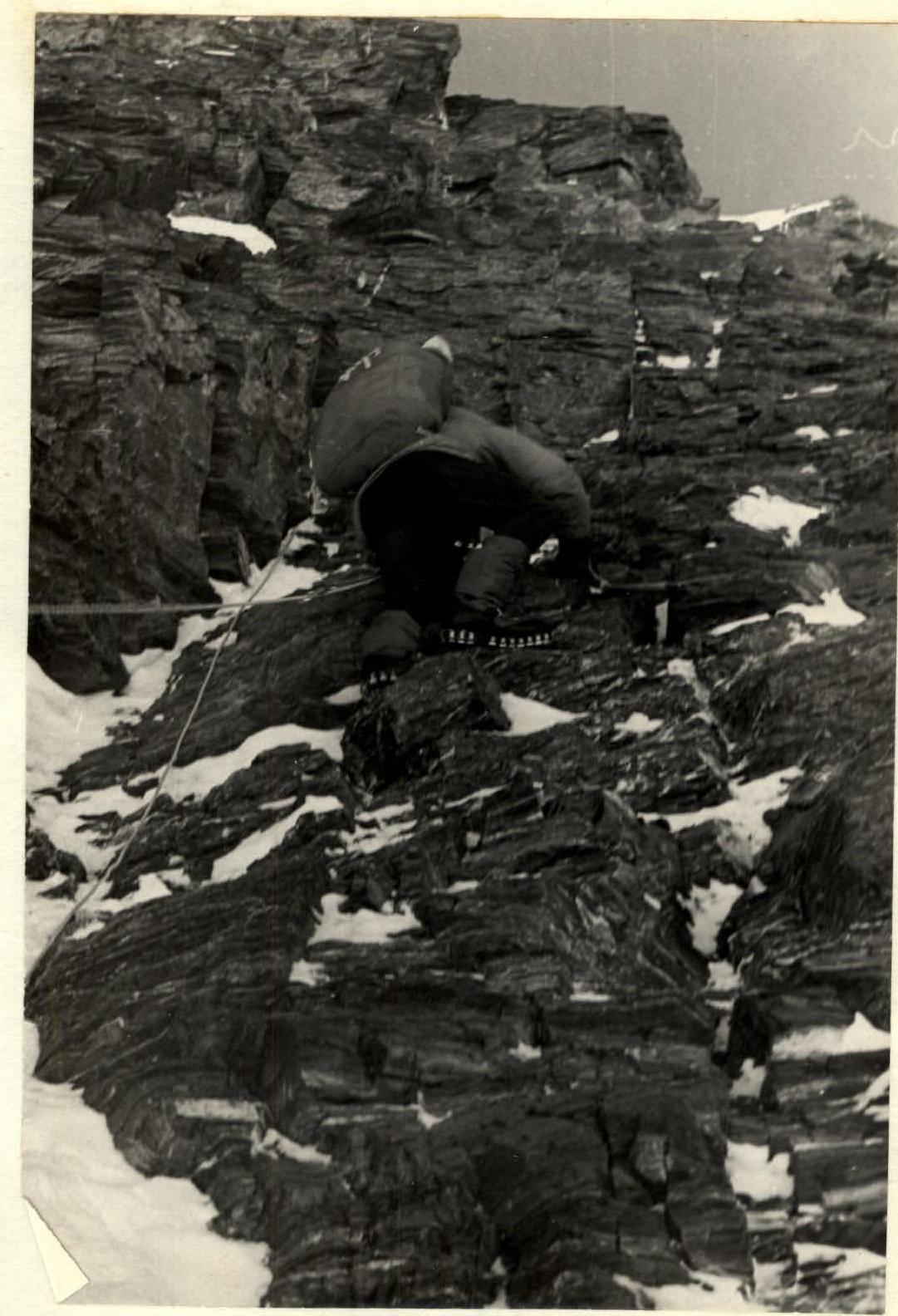
Photo 11. Section 17–18.
Day 3. August 23.
The section is rockfall-prone. We proceed along a firn slope towards a pinnacle, enjoying simple climbing. We reach its summit and continue along a sharp ridge to a snowy slope, where the snow is deep in places. We use ice axe protection.
A short, 30 m rock climb follows, with steep, crumbling, and icy rocks. Vadim Smirnov, the lightest climber, makes his way up carefully. The ropes are fixed, and we continue with an easy traverse across snowy fields, encountering only one 10 m ice wall that is quickly passed. We turn right after an icefall and, following a rocky ridge on our right, reach the upper plateau. We head to our planned bivouac site, an isolated rock 300 m towards Peak Saladina. It's 15:00, and the plateau is warm.
We dig a cave and settle in. We also cache supplies and fuel for the next stage.
We celebrate:
- Repin's birthday.
In 6 hours, we've ascended to 6200 m, using:
- 17 rock pitons
- 3 ice screws.
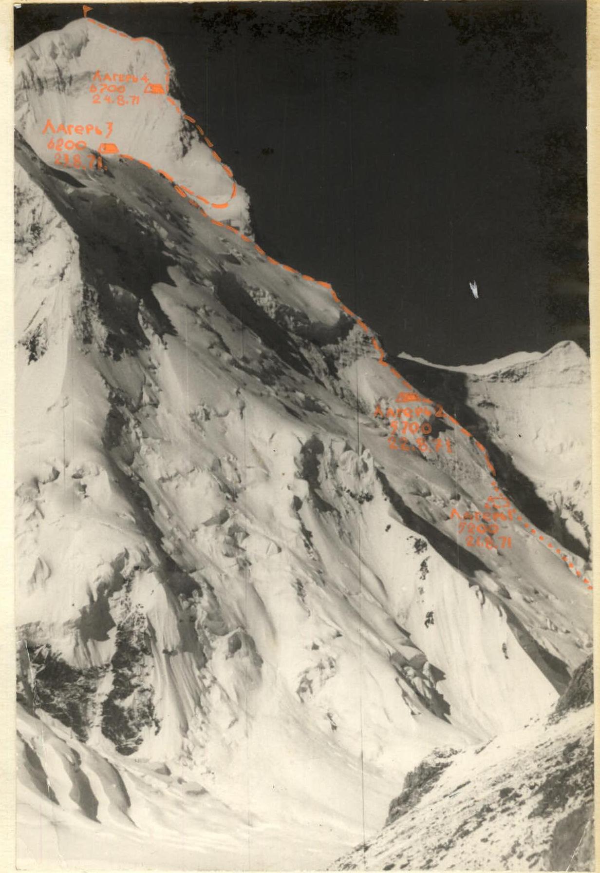
Day 4. August 24.
The weather is perfect, not a cloud in sight. We depart at 9:00 AM, traversing snowy fields on the plateau (soft snow up to 20 cm deep) at a good pace. It's hot, and we even remove our down jackets. There's no wind.
We reach the first ice drop and continue right to the edge of the rocks and snow for safer passage. Along this boundary, we approach an ice-firn ascent. We use piton and ice axe protection.
We then reach the base of the "red rocks." The rocks are step-like and weathered. We gradually move right under a wall — a critical section of the route. The rock wall is 80-85° steep, with the upper part reaching 90° over 2-3 m, spanning 40 m. Here, a ledge serves as a resting point and belay stance. Two to three people can gather.
Beyond this, a complex, fractured wall with rock blocks leads to an internal corner and then to step-like rocks. We initially move 1.5 ropes to the right and then 2 ropes to the left to a saddle in the ridge. Ahead lies a steep firn-ice slope (see Photo 15), with "sheep's foreheads" on the right. We begin on firn and ice, then transition to rocks. This section is challenging. The wind picks up.
Above this section lies a depression — our Camp 4. It's 17:30.
We've ascended to 6700 m in 8 hours 30 minutes, using 12 rock and 6 ice pitons. Ropes were fixed on the rocks.
Day 5. August 25.
The decisive summit push. We depart at 9:00 AM, carrying a tent and stove as a precaution. The sky is partly cloudy, with wind. It's cold.
We ascend a snowy ridge to the base of a rock. To the left lies snow and ice; the rocks are highly polished slabs over 120 m. We decide to ascend via the rocks. Hrebtov and Ilyinsky take turns on this section, and we reach a snowy-icy slope in the upper part, steep up to 60°.
Progress becomes harder as the wind strengthens and snow falls. The firn slope, with patches of ice, leads to rocks: first, a steep rock wall to a narrow, snow-covered ledge, then a broad internal corner that exits onto the ridge. From here, we traverse on the boundary between rocks and snow, reaching a snowy dome that transitions into a broad ridge with minor undulations.
We reach the summit at 15:30. Weather conditions:
- Cold
- Strong wind
- Snowfall
In the summit cairn, we find a note from a Moscow team led by Putrin, who ascended via Romanov's route on August 22, 1971. "Happy Birthday to E. Ilyinsky!"
We begin our descent at 16:00, reaching Camp 4 (6700 m) by 19:30.
The night is marked by bad weather and strong winds. The ascent from 6700 m to the summit took 6 hours 30 minutes, using:
- 16 rock pitons
- 2 ice screws.
Day 6. August 26.
We depart at 9:00 AM. The wind is strong, and it's cold. We descend to the cave. The plateau is covered with fresh snow, making progress difficult due to poor visibility. We reach the cave by 14:00, where we can rest.
Day 7. August 27, 1971.
Snow falls, with wind and cold. We decide to wait out the avalanche danger. Supplies and fuel are sufficient for over a week.
Later in the day, a strong wind develops, almost reaching hurricane force. The entrance to the cave is snowed in. We plan to descend the next day if the wind continues.
Day 8. August 28.
We depart at 8:00 AM. It's cold, with strong winds. The fresh snow has been blown away. We quickly descend from the plateau, reaching the "sickle" by 20:00 (4700 m). The weather improves significantly, with clear skies and almost no wind. We camp here, using the previous night's bivouac site of the Leningrad climbers from 1970.
The descent involves 26 rappels and sports descents.
Day 9. August 29.
We depart at 9:00 AM. It's warm and clear. By 12:00, the entire group has descended from the route and arrives at the base camp by 13:00.
The descent involved 6 sports descents. The total time taken to ascend Khan-Tengri (6995 m) was 42 hours.
The descent followed the ascent route, taking 26 hours. A total of 82 rock pitons and 39 ice pitons were used throughout the climb, with the entire route completed using free climbing techniques.
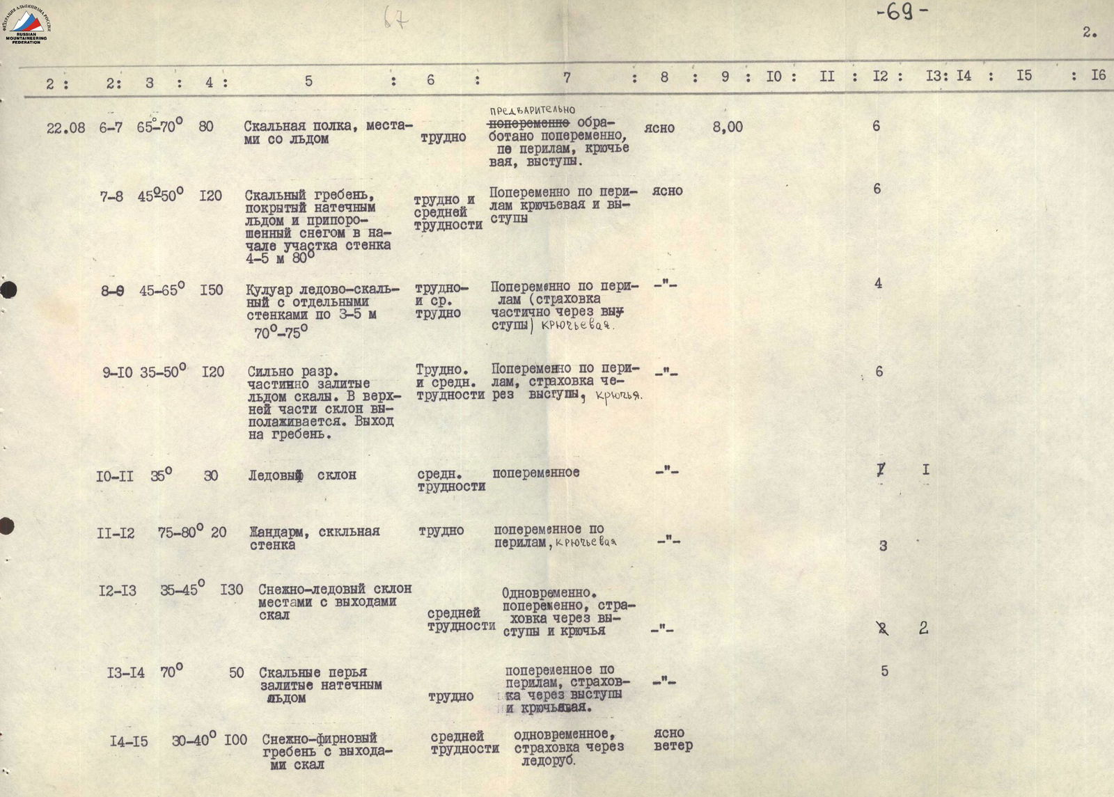
Table of Main Climbing Route Characteristics
- Climbing route — Khan-Tengri, north route, Kuzmin's path, 6B category of difficulty.
- Elevation gain — approximately 3000 m.
- Length of most challenging sections — around 1300-1400 m.
- Average slope of the route (excluding the plateau) — approximately 50°.
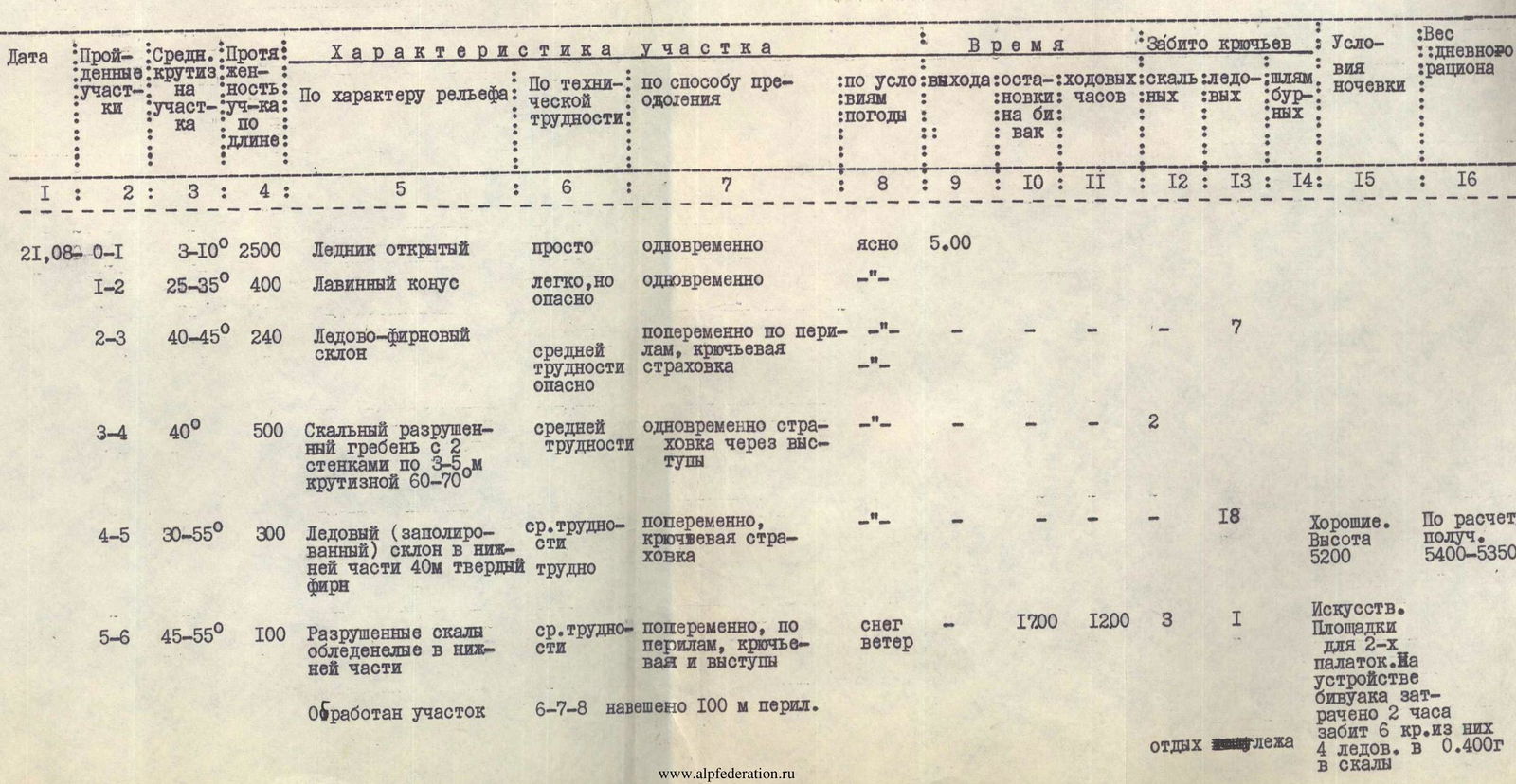
| Date | Sections Covered | Average Slope | Length | Section Characteristics | Technical Difficulty | Climbing Method | Time | Pitons Used | Bivouac Conditions | Daily Ration Weight (kg) |
|---|---|---|---|---|---|---|---|---|---|---|
| Weather | Rock | Ice | Bolt | |||||||
| Departure | Stop for Bivouac | Climbing Hours | ||||||||
| 21.08 | ||||||||||
| 0–1 | Open Glacier | 3–10° | 2500 m | Simple | Simultaneous | Clear | 5:00 | |||
| 1–2 | Avalanche Cone | 25–35° | 400 m | Easy but hazardous | Simultaneous | — | ||||
| 2–3 | Ice-Firn Slope | 40–45° | 240 m | Medium difficulty, hazardous | Alternating, piton protection | — | 7 | |||
| 3–4 | Weathered Rock Ridge | 40° | 500 m | With two walls 3–5 m, 60–70° | Medium difficulty | Simultaneous, protection through outcrops | — | 2 | ||
| 4–5 | Polished Ice Slope | 30–55° | 300 m | Lower part 40 m, hard firn | Medium difficulty | Alternating, piton protection | — | 18 | ||
| 5–6 | Weathered Rocks | 45–55° | 100 m | Icy in lower part | Medium difficulty | Alternating, piton and outcrop protection | Snow, Wind | 17:00 | 12:00 | 3 |
| Section processed | 100 m fixed ropes | |||||||||
| 22.08 | ||||||||||
| 6–7 | Rock Shelf | 65–70° | 80 m | Icy in places | Difficult | Alternating, processed, piton and outcrop protection | Clear | 8:00 | 6 | |
| 7–8 | Rock Ridge | 45–50° | 120 m | Icy, snow-covered | Difficult and medium | Alternating, piton and outcrop protection | Clear | 6 | ||
| 8–9 | Ice-Rock Couloir | 45–65° | 150 m | With walls 3–5 m, 70–75° | Difficult and medium | Alternating, partial outcrop protection, piton | — | 4 | ||
| 9–10 | Rocks | 35–50° | 120 m | Weathered, icy | Difficult and medium | Alternating, outcrop and piton protection | — | 6 | ||
| 10–11 | Ice Slope | 35° | 30 m | Medium difficulty | Alternating | — | 7 | |||
| 11–12 | Pinnacle | 75–80° | 20 m | Rock wall | Difficult | Alternating, piton protection | — | 3 | ||
| 12–13 | Snow-Ice Slope | 35–45° | 130 m | With rock outcrops | Medium difficulty | Simultaneous and alternating, outcrop and piton protection | — | 5 | ||
| 13–14 | Rock Needles | 70° | 50 m | Icy | Difficult | Alternating, piton protection | — | |||
| 14–15 | Snow-Firn Ridge | 30–40° | 100 m | With rock outcrops | Medium difficulty | Simultaneous, ice axe protection | Clear, Wind | |||
| 23.08 | ||||||||||
| 15–16 | Snow-Firn Slope | 20–30° | 300 m | Simple | Simultaneous | Clear, Wind | 17:00 | 9:00 | ||
| 16–17 | Snow-Firn Slope | 25–45° | 250 m | Transitions to ice 20 m | Easy and medium | Simultaneous, then fixed ropes | Clear, then Cold | 9:00 | 1 | |
| 17–18 | Rock Chimney (85°) | 60° | 30 m | With icy couloir | Difficult | Alternating, piton protection | — | 4 | ||
| 18–19 | Rock Wall | 40–55° | 100 m | Weathered, icy | Difficult — rockfall hazard | Alternating, piton protection | — | 8 | ||
| 19–20 | Firn Slope | 30–45° | 180 m | Pinnacle. Sharp firn ridge, deep snow. | Medium difficulty | Simultaneous, ice axe protection | — | |||
| 20–21 | Steep Rocks | 70–85° | 30 m | Weathered, icy | Difficult | Alternating, fixed ropes, piton protection | — | 5 | ||
| 21–22 | Weathered Rocks | 50–60° | 50 m | Icy, exit to ridge | Medium difficulty | Alternating, outcrop protection | — | |||
| 22–23 | Snowy Fields | 10–30° | 350 m | Easy | Simultaneous | Good | ||||
| 23–24 | Ice-Firn Wall | 40° | 10 m | Medium difficulty | Alternating, fixed ropes, piton and ice axe protection | — | 2 | |||
| 24–25 | Snowy Fields, Plateau | 15° | 1000 m | Deep snow | Not difficult but tiring | Simultaneous | Clear, Warm | — | 15:00 | 6:00 |
| 24.08 | ||||||||||
| 25–26 | Plateau. Snowy Fields | 0–25° | About 2000 m | Soft, deep snow | Simple | Simultaneous, changing lead | Clear, Very Hot | 9:00 | ||
| 25.08 | ||||||||||
| 26–27 | Ice-Firn Ascent | 35–40° | 150 m | Medium difficulty | Alternating, fixed ropes, piton and ice axe protection | Clear, Moderate Wind | 4 | |||
| 27.08 | ||||||||||
| 27–28 | Firn Fields | 25–35° | 250 m | Simple | Simultaneous | Wind | ||||
| 28–29 | Weathered, Step-like Rocks | 30–40° | 100 m | With ledges | Easy | Simultaneous | — | |||
| 29–30 | Rock Wall | 80–85° | 85 m | Transitions to wall with niche | Complex | Alternating, fixed ropes, piton protection | Wind | 8 | ||
| 30–31 | Steep, Step-like Rocks | 55–60° | 120 m | With debris | Medium difficulty | Simultaneous and alternating, outcrop protection | Wind | |||
| 31–32 | Firn-Ice Slope | 65–70° | 60 m | With "sheep's foreheads" on right | Difficult | Alternating, fixed ropes, piton protection | Wind | 4 | ||
| Fixed ropes on section 34–35 | 17:30 | 8:30 | ||||||||
| 25.08 | ||||||||||
| 32–33 | Snowy Ridge | 30° | 100 m | Easy | Simultaneous | Partly Cloudy, Wind | 9:00 | |||
| 33–34 | Polished Slabs | 60–65° | 120 m | Ice on left | Difficult | Alternating, fixed ropes, piton protection | Wind | 20 | ||
| 34–35 | Snow-Ice Slope | 30–60° | 250 m | Medium difficulty | Alternating, ice axe and piton protection | Snow | ||||
| 35–36 | Rock Wall | 55–60° | 140 m | Ledge on wall, broad internal corner | Complex | Alternating, fixed ropes, piton and outcrop protection | Wind | 6 | ||
| 25.08 | ||||||||||
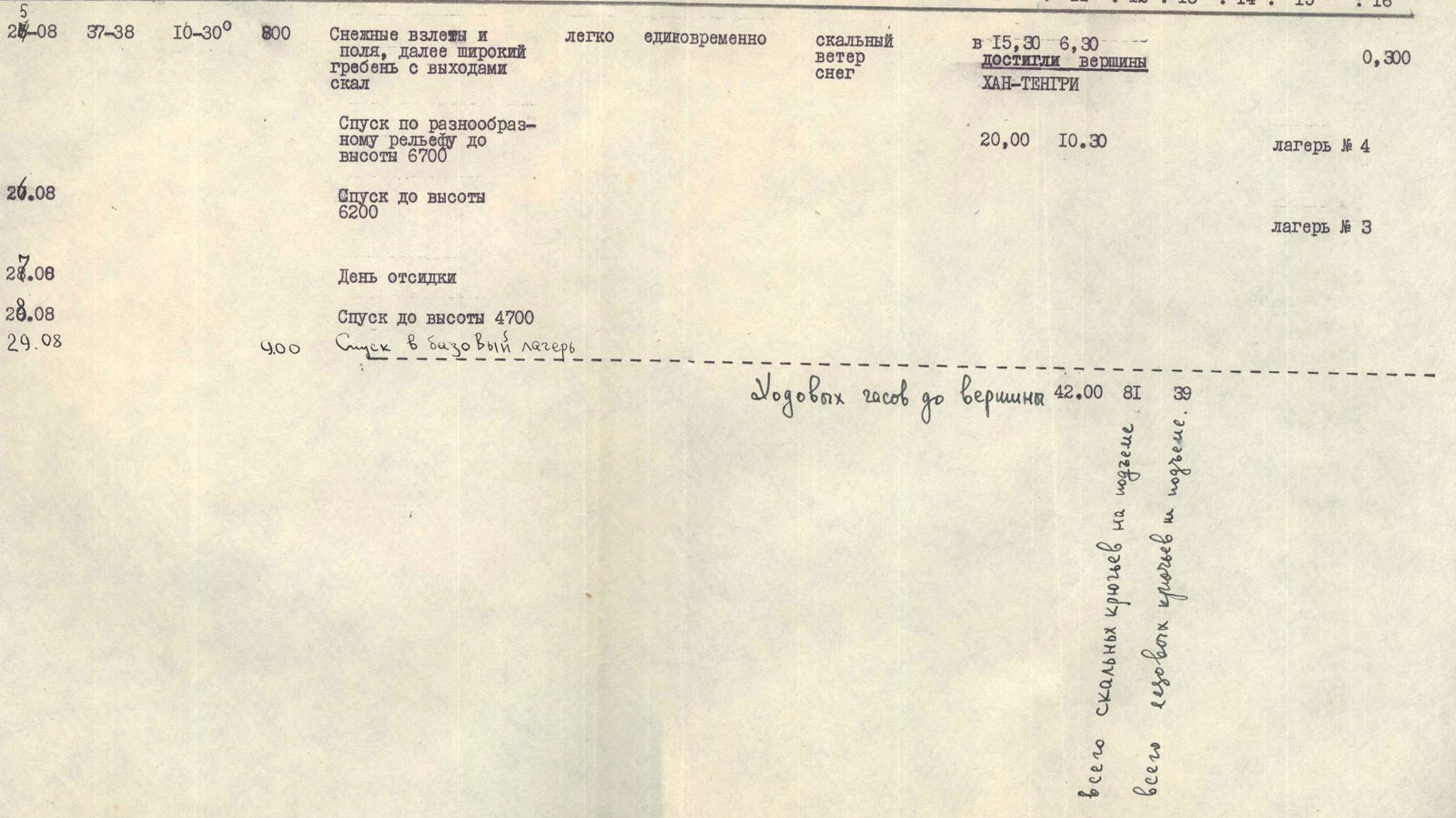
| 36–37 | Snowy Ascents and Fields | 10–30° | 800 m | Broad ridge with rock outcrops | Easy | Simultaneous | Windy, Snow | 15:30 | 6:30 | |
| 26.08 | Descent along varied terrain to 6700 m | 20:00 | 10:30 | |||||||
| 27.08 | Descent to 6200 m | |||||||||
| 28.08 | Day of rest | |||||||||
| 29.08 | Descent to 4700 m | |||||||||
| 29.08 | Descent to base camp | 400 m | ||||||||
| Total climbing hours to summit — 42:00. Total rock pitons on ascent — 82, ice pitons — 39. |