World Mountaineering Championship
High Altitude Class
National team of the Republic of Kazakhstan
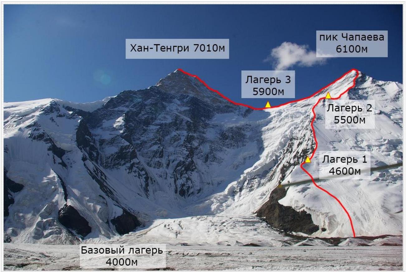
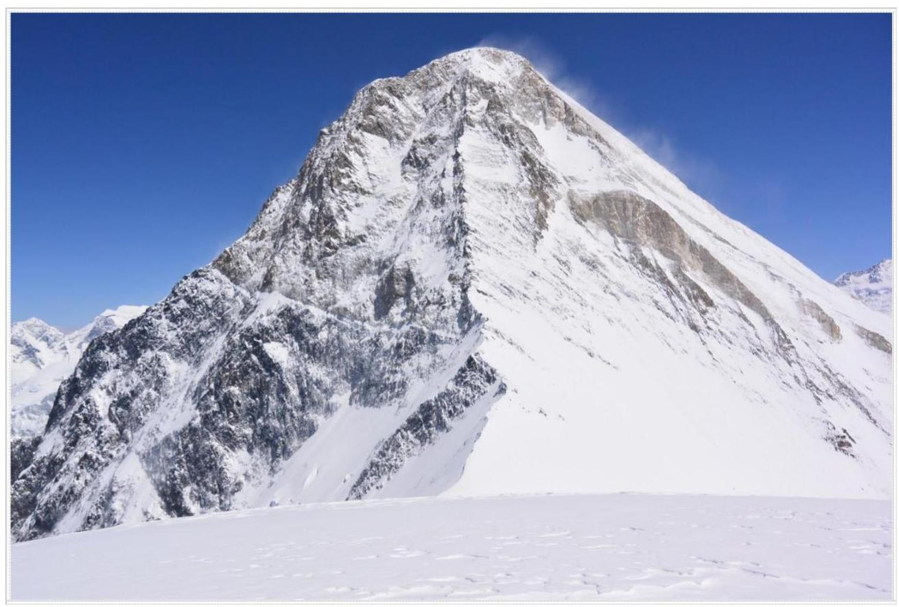
Peak Khan-Tengri, 7010 m
via NE edge of Chapayev Peak's shoulder (classic route), Solomatov route 5A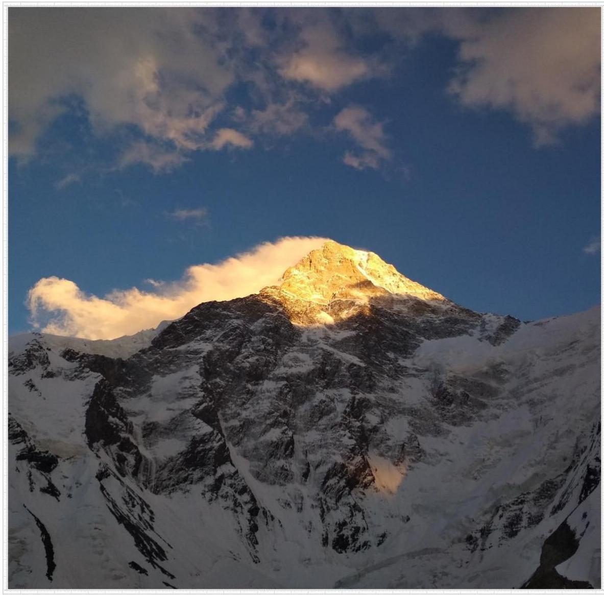
2019
Ascent Passport
- Region, gorge: Tian Shan, Tengri-Tag ridge
- Name of peak, route name: Peak Khan-Tengri, 6995 m, NE edge of Chapayev Peak's shoulder (B. Solomatov route, 1974)
- Complexity category: 5A
- Route type: combined
- Route elevation difference:
- Route elevation difference — 2900 m;
- Wall section — 40–50 m;
- Route length — 3500 m;
- Wall section length — 40–50 m;
- Length of sections with complexity category 5 — 50 m, including category 6 — 0 m.
- Average steepness of the entire route — 40°, main part — 40°.
- Team's working hours: 10 days including acclimatization.
- Team leader: V.T. Pivtsov (Master of Sports of International Class) Team member: T.M. Aubakirov (Candidate for Master of Sports) Coach: V.T. Pivtsov (Master of Sports of International Class)
- Route start — August 5, 2019 Summit — August 9, 2019 at 14:00
- Organization: FA and SS RK
General photo of the peak
Characteristics of the region and ascent object
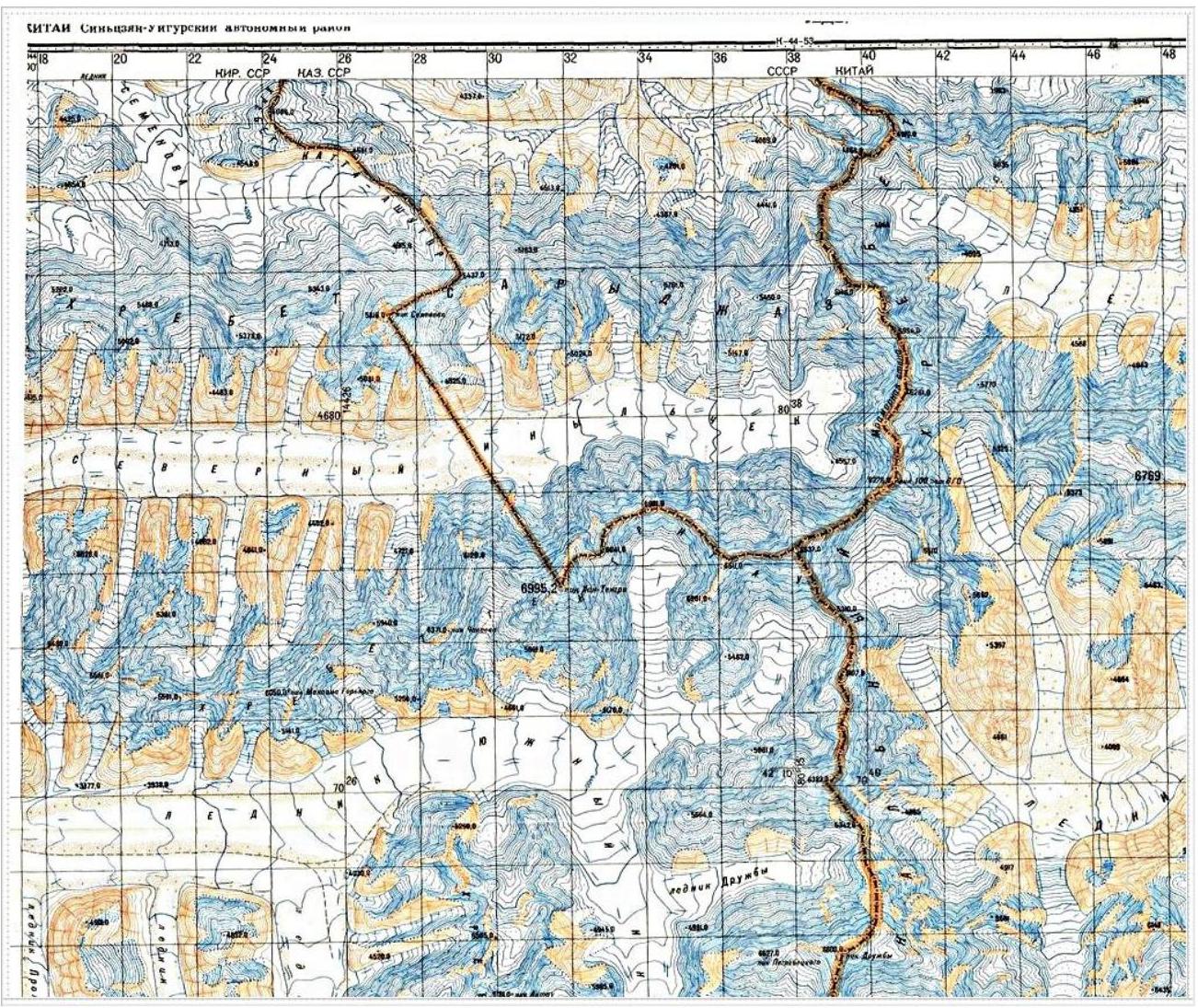
Central Tian Shan is located in Central Asia, mainly in Kyrgyzstan (western part) and China (eastern part), partially in Kazakhstan and Uzbekistan. Its length from west to east is about 2500 km, and from north to south — 300 km.
Khan-Tengri is a mountain peak, the highest point of the Republic of Kazakhstan on the border with Kyrgyzstan and China. According to some data, its height is 6995 m, according to others — 7010 m. Khan-Tengri is located in the eastern part of Central Tian Shan on the Tengri-Tag ridge.
Highest points: Peak Pobeda (7439 m) and Peak "Khan-Tengri" (7010 m). Central Tian Shan is characterized by alpine landscapes: sharp ridges are emphasized by gray-turquoise glaciers and dazzling snowfields; the diversity of alpine meadows is adjacent to dark coniferous forests of Tian Shan spruce. High-altitude tourism is mainly developed in this region. Ascent routes are diverse:
- rock
- snow and ice
- combined
Peak Khan-Tengri is the northernmost seven-thousander in the world. Approaches to the peak lie through large glaciers:
- South Inylchek (Kyrgyzstan)
- North Inylchek
Until mid-August, the approaches to the North Inylchek glacier are blocked by the mysterious Merzbacher Lake (3400 m), which suddenly fills and suddenly disappears. The northern side of the peak is rocky, descending like a wall to the North Inylchek glacier and is almost devoid of glaciation due to its great steepness.
Khan-Tengri was first mentioned in Chinese chronicles 1200 years ago. The first description of Khan-Tengri was made by Petr Semenov, later Semenov-Tian-Shansky. The peak was first conquered by Ukrainian mountaineer M.P. Pogrebetsky in 1931.
Region diagram
Route diagram in UIAA symbols
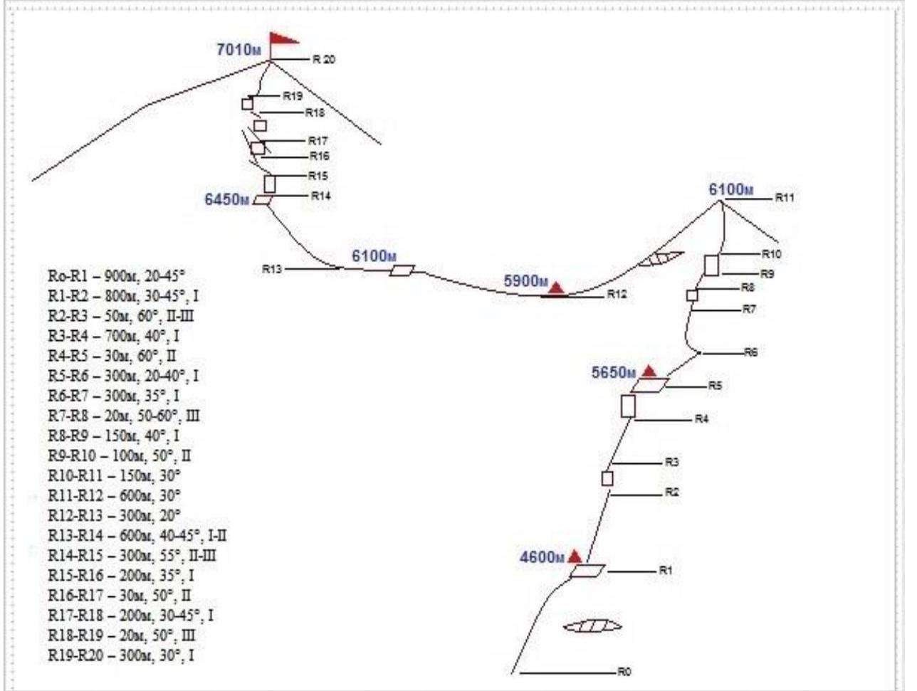
- R0–R1: 900 m, 20–45°
- R1–R2: 800 m, 30–45°, complexity category 1
- R2–R3: 50 m, 60°, complexity category 2–3
- R3–R4: 700 m, 40°, complexity category 1
- R4–R5: 30 m, 60°, complexity category 2
- R5–R6: 300 m, 20–40°, complexity category 1
- R6–R7: 300 m, 35°, complexity category 1
- R7–R8: 20 m, 50–60°, complexity category 3
- R8–R9: 150 m, 40°, complexity category 1
- R9–R10: 100 m, 50°, complexity category 2
- R10–R11: 150 m, 30°
- R11–R12: 600 m, 30°
- R12–R13: 300 m, 20°
- R13–R14: 600 m, 40–45°, complexity category 1–2
- R14–R15: 300 m, 55°, complexity category 2–3
- R15–R16: 200 m, 35°, complexity category 1
- R16–R17: 30 m, 50°, complexity category 2
- R17–R18: 200 m, 30–45°, complexity category 1
- R18–R19: 20 m, 50°, complexity category 3
- R19–R20: 300 m, 30°, complexity category 1
Technical description of the route
The section from the glacier to the first camp is a snowy slope 25–40°, before reaching the ridge, the slope steepness increases to 45°. This steep section, 100 m long, leads to the ridge. Here, on a talus shelf, is the first camp (4600 m). The site can accommodate 12–15 tents. 100 m higher up the ridge, there is another convenient site, but its capacity is only 3–4 tents. The campsites are completely safe. The snow condition on the slope depends on the weather and season. The path from Base Camp to Camp 1 takes an average of 3 hours.
The path from Camp 1 to Camp 2 takes 6–7 hours at an average pace and represents a snow-ice edge with rock outcrops. In the middle of the ascent, there are simple, destroyed rocks, 50 m, with a steepness of 60°, and before reaching the shoulder, there is a 120 m snow-ice ascent with a slope of 55°. Ropes are stretched along the entire length. Camp 2 is located at an altitude of 5650 m on a clearly defined shoulder. The site is very convenient.
The transition from Camp 2 to Camp 3 passes through the shoulder of Chapayev Peak (6100 m). The ascent starts along a snowy slope, 35°, approximately 150 m long, to a narrow snowy knife-edge. Just before reaching the knife-edge, a rope is fixed and continues to the shoulder of Chapayev Peak. The length of the knife-edge is about 30 m, followed by a slope, 250 m long, with a steepness of 30°, leading to rocks. When passing along this slope, it is necessary to be extremely attentive — it can be avalanche-prone at the beginning of the season. 40 m of rocks with a steepness of up to 70° end on a talus slope with a steepness of 30–35° and ice sections, 200 m long. Then, again, there are rock sections, 40–60°, 150 m, requiring cautious passage due to loose stones! After the rocks, there is a final ascent to the shoulder of Chapayev Peak along a snow-firn slope, 150 m. The transition to this point from Camp 2 takes an average of 5–6 hours. The descent from the shoulder towards the saddle is technically simple but passes along a narrow ridge between massive cornices hanging to the north and a steep snowy slope with southern exposure; in case of snowfall, it can be avalanche-prone here. It is recommended to move in rope teams. Camp 3 (5900 m) is located in the widest part of the saddle. The descent from the shoulder to Camp 3 takes 1 hour. In recent years, a bergschrund with an almost vertical 20-meter wall has opened up in this section.
The path from the saddle to the summit leads along the western ridge. Ropes start at an altitude of 5900 m from the ascent to a rock wall, 50°, 40 m. Further, bypassing a gendarme on the right, to the exit into a talus couloir and along it to the next rope, 100 m. From the end of the couloir, ropes continue practically to the summit without interruption. The path mainly passes along rocks, sometimes bypassing steep sections. A rocky ridge, 35°, leads to an altitude of 6700 m. From here, there is a traverse, 100 m to the right, into a couloir, and an ascent along the couloir, 150 m. In the couloir, there is firn; in the middle, there is a rock wall, 70°, 15 m. The exit from the couloir is to the right onto the ridge, 70 m. On the ridge, there is a narrow firn knife-edge (10 m), leading to rocks. The rocks are simple; after 40 m, they end on a snowy dome (6900 m). A firn slope, 150 m, with a steepness of 30°, leads to a narrow snowy ridge, behind which, 120 m away, on the border of snow and stones, a tripod is installed.
Team's tactical actions
On August 5, they departed to Camp 1; the weather was clear, temperature was –5 °C.
On August 6, they departed at 9:00 to Camp 2; the weather was clear, wind 15 m/s. The trail was snowed under, so they had to trailblaze again.
On August 7, from Camp 2, they departed at 9:00; wind 20 m/s, closer to the dome 20–25 m/s. They trailblazed again, pulling out ropes from the snow. The weather was clear. On this day, they received a forecast for August 8, expecting wind up to 80 km/h. They stayed in camp. A rumble was heard in the summit area.
On August 8, they stayed in Camp 3.
On August 9, they made a summit push from Camp 3 (5900 m). The temperature at night was –10 °C. They departed at 6:00; the weather was changeable. Closer to 12:00, clouds rolled in, visibility became 100 m. The wind was gusty, from 10 to 30 m/s. The summit push and return to the assault camp took 8 hours.
On August 10, they descended to Base Camp.
Photos from the route
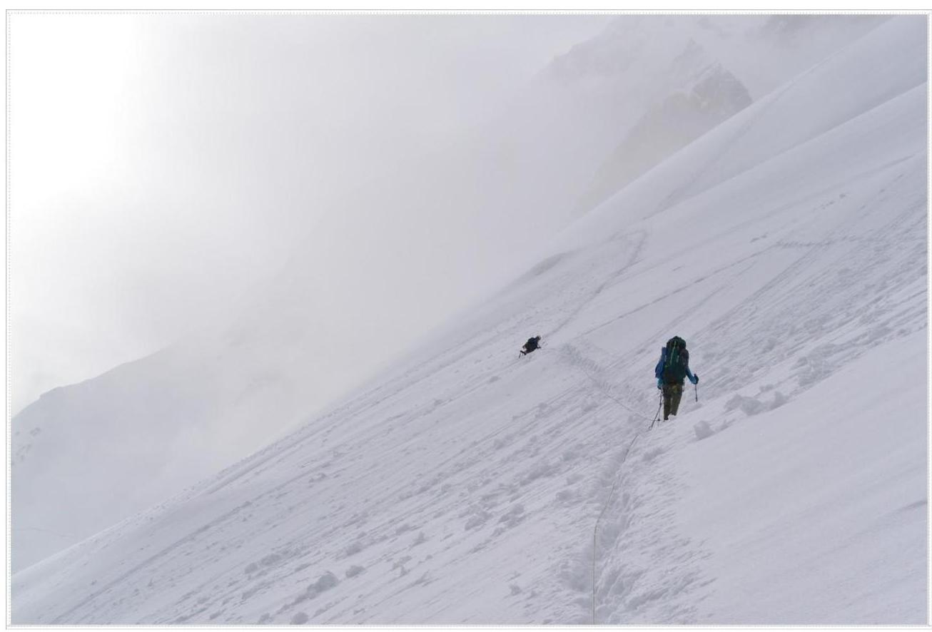
Traverse on the way to Camp 1
Start of the path to Camp 2
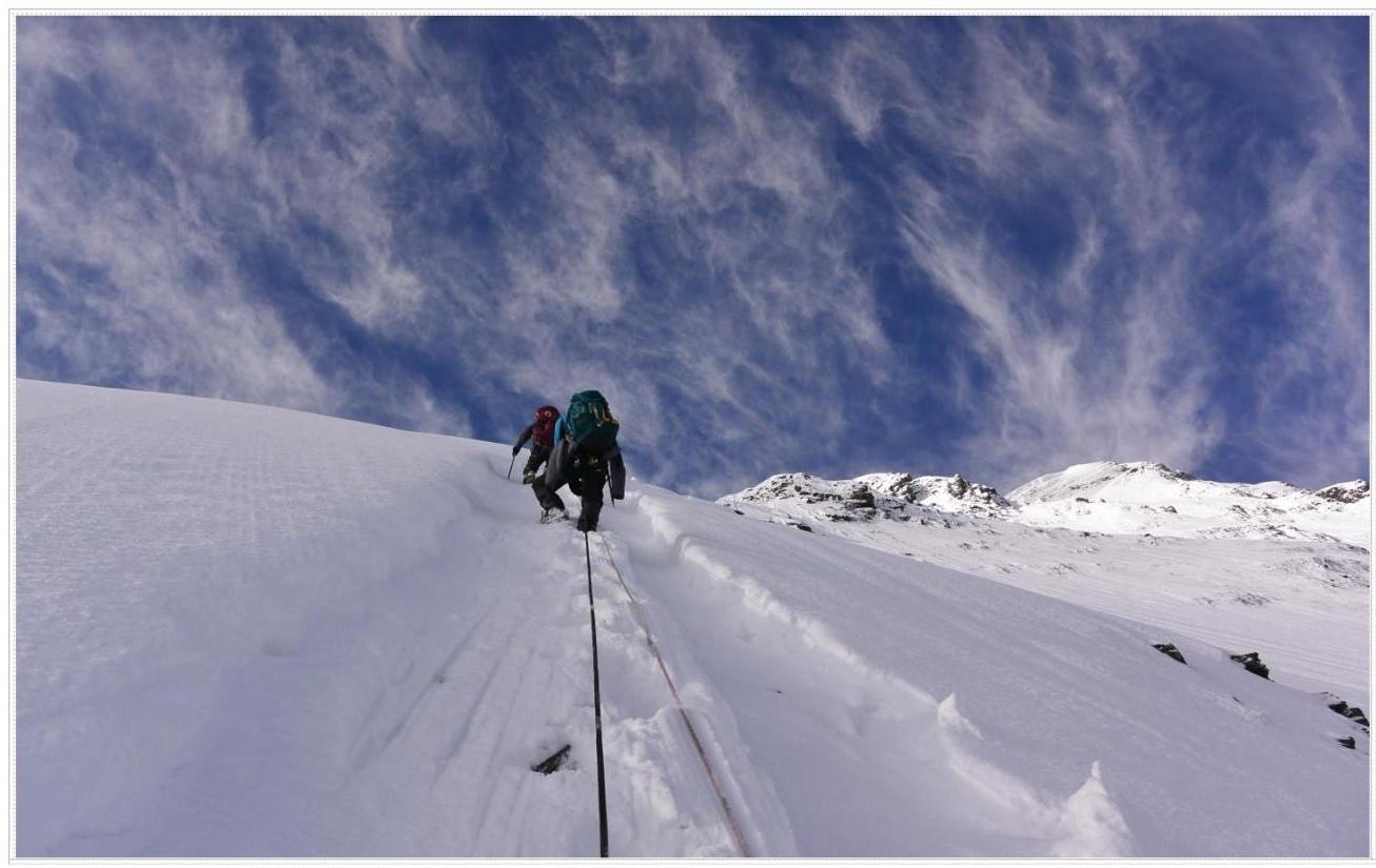
Summit ridge

Section before reaching the summit dome
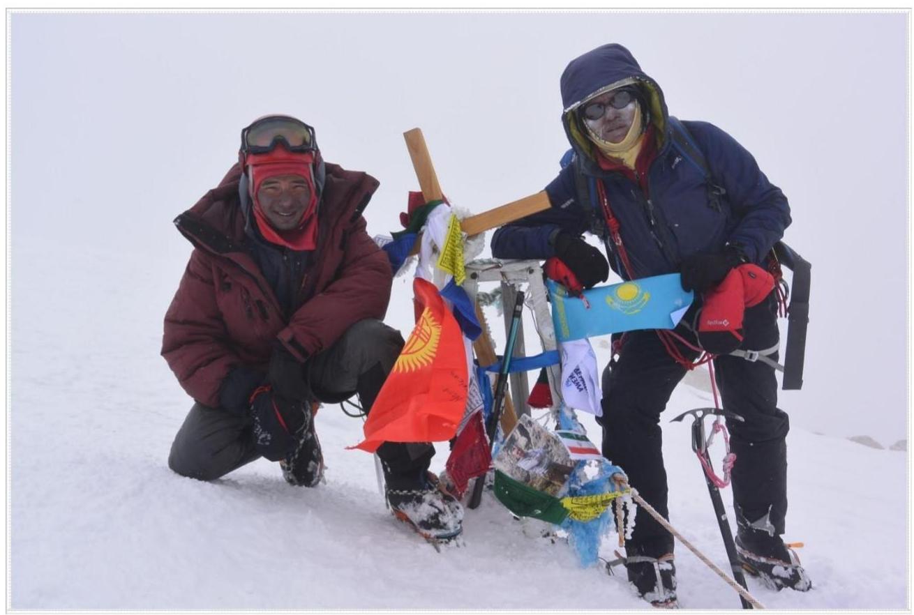
Photo on the summit