
Ascent Passport
- Class of high-altitude ascents;
- Tian-Shan, Tengri-Tag ridge;
- Khan-Tengri peak via the NE edge of Chapayev peak's shoulder;
- Difficulty category – 5B;
- Elevation gain – 2910 m; Distance – 6160 m; Distance of sections with V cat. diff. – 960 m; Average steepness of the main part of the route – 40°;
- Team's travel hours – 18; days – 3;
- Overnights: 1 – in a tent, at an altitude of 5600 m; 2 – in a tent on the saddle at an altitude of 5950 m;
- Leader: Moiseev Alexander Anatolyevich, Master of Sports, 344000, Rostov-on-Don, Kosmonavtov Ave., 14/15, apt. 235; Participants: Makovkin M.V., Candidate for Master of Sports, Podlesny D., 1st sports category, Politiko I.E., 1st sports category, Shishkin D., 1st sports category;
- Senior coach Artsishevsky Yu.Yu., Master of Sports of International Class;
- Departure to the route: August 12, 2005; Summit: August 14, 2005; Return to base camp: August 15, 2005;
- Rostov Region Federation of Mountaineering and Rock Climbing, 344028, Rostov-on-Don, 1st Konnaia Armiya St., 4.
Brief Geographical Overview of the Ascent Area
Khan-Tengri peak (7010 m) is located in the Tengri-Tag ridge of Central Tian-Shan. The area where it is situated represents a hub of the highest elevations of the entire Tian-Shan mountain system. Here are located peaks:
- Peak Pobeda (7439 m)
- Peak Voennykh Topografov (6870 m)
- Peak Druzhby (6800 m)
- Peak Pogrebeцкого (6527 m)
- and others.
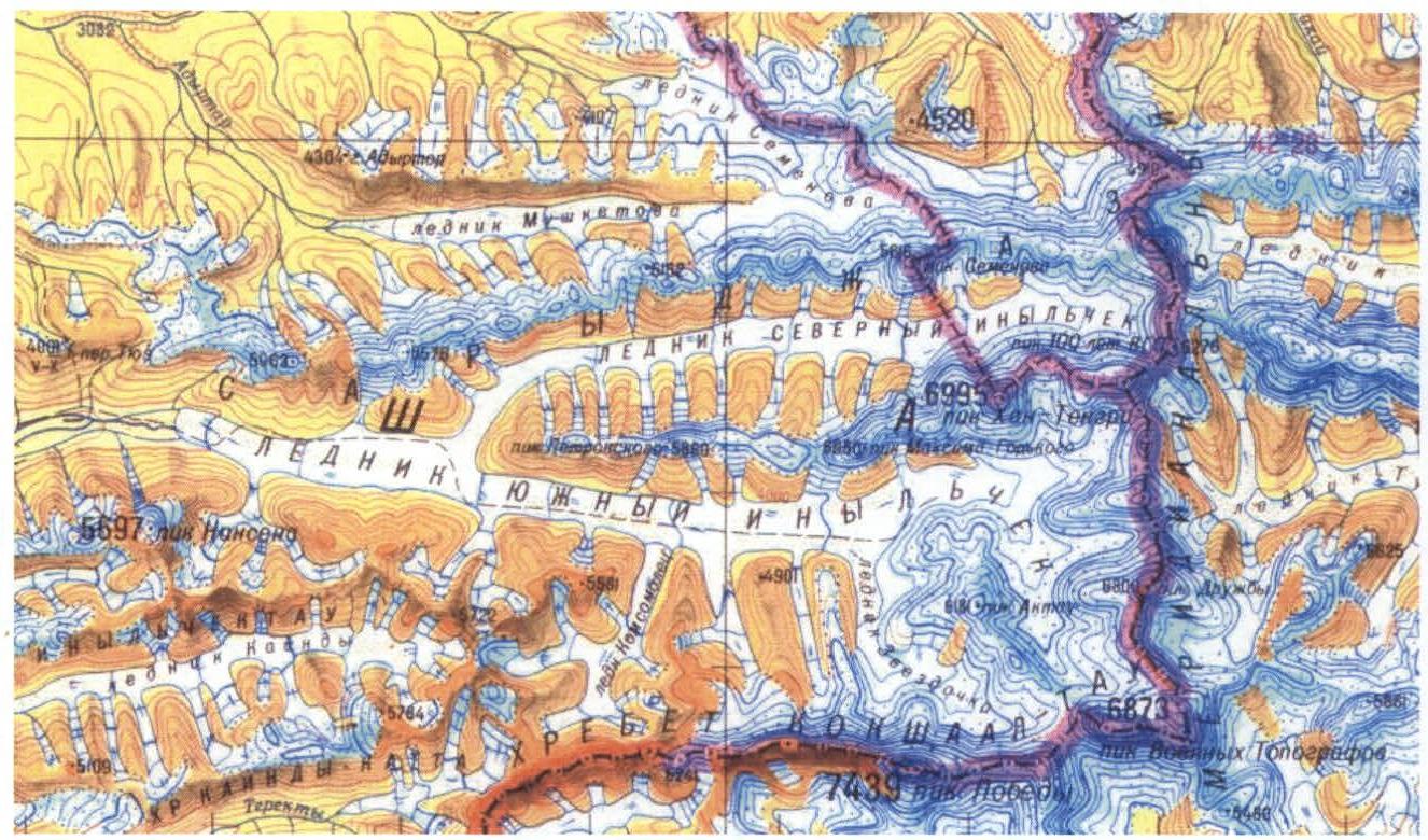
To the north of the Tengri-Tag ridge lies the Sary-Jaz ridge, which is more extensive. The ridges are separated by the North Inylchek glacier. To the south of the Tengri-Tag ridge lies the Kokshaal-Tau ridge with the highest peak of Tian-Shan – Peak Pobeda. Its northern slopes descend to the Zvezdochka glacier.
The area is well-developed for mountaineers. The base camp is located on the lateral moraine of the North Inylchek glacier. Helicopter delivery is possible from:
- Karkara
- Bayankol
- Maydaadyr
Flight time – 35–40 min.
Khan-Tengri peak drops to the north and east with walls having an elevation gain of over 2500 m. From the west and east, it is accessible via two steep ridges, and from the south and southwest, it is bounded by steep slopes with two edges, one of which (south-southwest) drops with a one-and-a-half-kilometer wall.
18 routes have been laid to the summit. Neighboring peaks on the ridge:
- To the west – Chapayev peak (6371 m)
- To the east – Peak 6200 (Saldin's peak)
The approach to the route from the base camp takes 40 min.
Preparation for the Ascent
The plan for preparing for the ascent, along with training in Rostov-on-Don (functional, technical, and tactical), included training camps and sports gatherings in the Caucasus:
- In February, the team conducted training camps in Prielbrusye
- In May – in the Uzunkol valley
Tactical Actions of the Team
The ascent was made according to the tactical plan. On the first day, August 12, the team ascended to an altitude of 5600 m and spent the night in tents.
On the second day, August 13, the team ascended to the shoulder of Chapayev peak, to an altitude of 6300 m, descended further to the saddle at 5950 m, and spent the night in tents.
On the third day, August 14, 2005, the team ascended to the summit of Khan-Tengri and descended to the camp at 5950 m and spent the night in tents.
The next day, August 15, 2005, the team descended to the base camp on the North Inylchek glacier.
Time spent on the route:
- August 12, 2005: 8:00–14:00
- August 13, 2005: 10:00–14:00
- August 14, 2005: 6:00–14:00 (summit) – 17:30 (saddle)
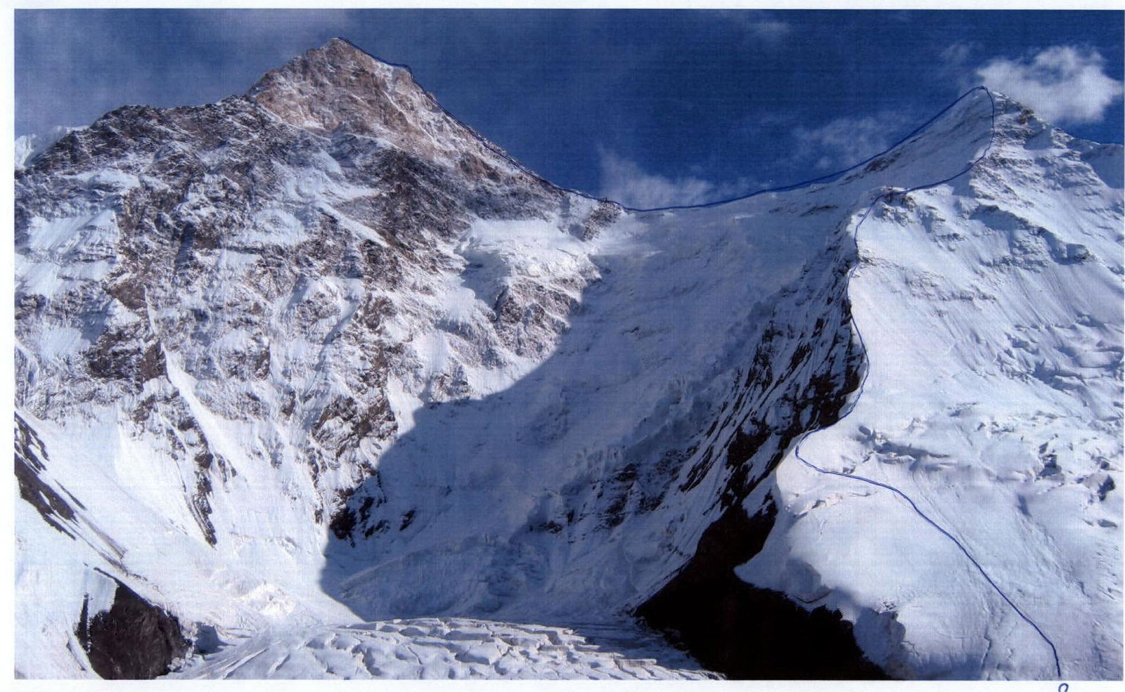
General photo of the summit. Taken from the base camp on the North Inylchek glacier.
1 – Khudyakov's route, 1971, N counterfort of N wall; 2 – Gorbenko's route, 1987, N wall; 3 – Pogorelov's route, 1993, left part of N wall; 4 – Studenin's route, 1974, center of N wall; 5 – Myslovsky's route, 1974, center of N wall; 6 – Koroteev's route, 1986, center of N wall; 7 – Moiseev's route, 1988, right part of E wall. 8 – Route of the team of the Rostov Regional Federation of Mountaineering and Rock Climbing, 2005.

In the photo: On descent. Rocky belt at an altitude of 7800 m.
In the photo: passing the rocky belt at 6100 m before reaching the shoulder of Chapayev peak.