-
High-altitude technical class.
-
Central Tien-Shan (Tengri-Tag).
-
Peak 6250 m via the right part of the N wall and W ridge.
-
Proposed — 5B category of difficulty, first ascent.
-
Height difference 2250 m, length — 2900 m.
Length of sections with 5 category of difficulty — 1710 m, 6 category of difficulty — 80 m. Average slope — 50°
- Pitons hammered:
Rock 42, chocks 25, ice screws 102
- Team's working hours: 30 hours, days — 5
- Overnights: 1, 2, 3, 4 — in a tent, lying down, platform cut out in a snowy ridge; 5 — in a tent, lying down on a scree shelf; 6, 7 — in a tent, lying down on a saddle.
- Leader: Moskalyov Vladimir Borisovich, Candidate Master of Sports
Participants:
- Nikolaev Oleg Bazyrovich, Candidate Master of Sports
- Obikhod Vladimir Nikolayevich, Candidate Master of Sports
- Petrov Nikolay Yevgenyevich, Candidate Master of Sports
- Yanochkin Vladimir Ivanovich, Candidate Master of Sports
Coach: Zasetsky Vladimir Georgiyevich, Candidate Master of Sports.
-
Departure to the route: August 12, 1985, summit — August 18, 1985, return — August 20, 1985.
-
Organization: MGS DSO "Burevestnik"
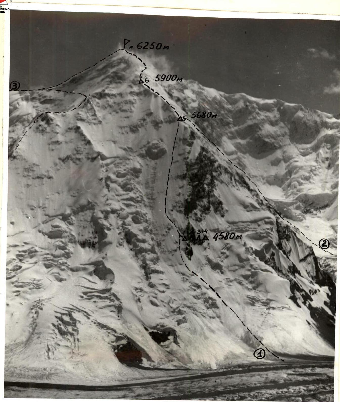 (1) Team's route; (2) — Grebenshchikov's route in 1975 on p. 6250 m; (3) — path to p. 6250 m from the saddle.
Photo 1. General photo of the summit. Taken from the moraine of l. S. Inylchek (4100 m) on August 4, 1985, S = 3 km, "Lyubitel" camera, lens No.4.
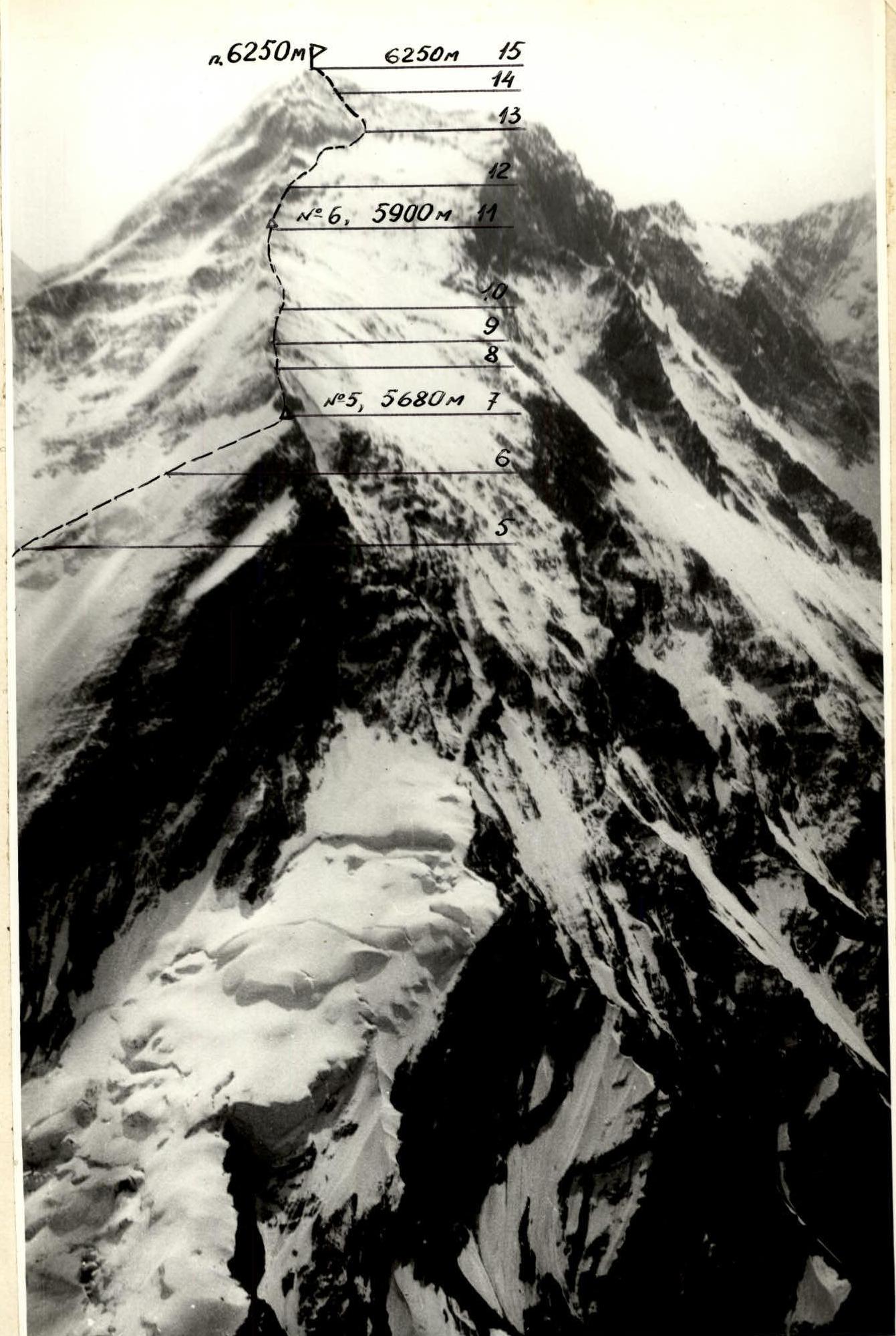
Photo 2. Profile of the wall of p. 6250 from the West. The photo was taken from a helicopter on August 22, 1985. S = 2 km, FED-3 camera.
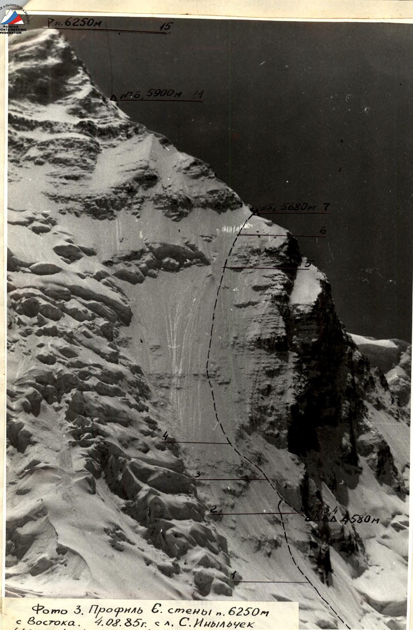
Photo 3. Profile of the N wall of p. 6250 m from the East. August 4, 1985, sl. S. Inylchek (4000 m), S = 2 km, "Lyubitel" camera, lens No.2.
Tactical actions of the team
The team's actions on the route were determined by the tactical plan of the ascent. To avoid avalanche and rockfall danger, the lower part of the route to the first overnight stay was traversed in the early morning hours. We stopped for the night at 12:00. Thus, the group had a day to observe the most complex part of the route. However, bad weather forced us to observe for three more days. The overnight platform was cut out in a snowy ridge and lined with flat stones.
The observation confirmed the tactical assumptions of the plan, and also showed the possibility of safe passage of the wall in the daytime.
The sections of the route (R2-R7) are characterized by a complete lack of platforms for rest. At best, steps were cut out at the belay points. Therefore, water was stored in a flask. Snacks were taken while moving.
Possible overnight stays in case of bad weather — to the right on the edge 100-120 m from the route.
The first pair moved, leaving pitons for the second trio. Movement — alternately with a change of lead.
The first in the rope team used an "ice axe hook" and an ice axe.
Overnights:
- Overnight 5 — cut out in the snow.
- Overnight 6 — laid out on a ridge shelf made of flat stones.
Around the overnight stays, belay stations were organized. All overnight stays — lying down.
Belay lines were set up on sections R1-R2 — in the upper part, R3-R4, R7-R8, R9-R10, R13-R14. The entire route was traversed in crampons by all participants.
Particular difficulty was presented for the first to pass sections R1-R2 (in the upper part), R3-R4, R6-R7, R14-R15. Here it was extremely difficult to organize belay — ice on the rock.
Under the ice crust, there are voids and ice bridges. In order to organize a belay or simply move from a spot, it is necessary to chop off a large amount of this snow-ice mass.
Throughout the route and at overnight stays, regular and stable radio communication was maintained with the camp and other groups.
After descending to the saddle between p. 6250 and Khan-Tengri, in accordance with the tactical plan and instructions from the rescue team leader, the team observed the descent of Urbansky's group from p. Khan-Tengri.
The descent to the north was associated, according to Urbansky, with increased avalanche danger and technical difficulties, so both groups, in agreement with the base camp, descended to the south, to l. Yu. Inylchek.
It should be noted that the good organization of overnight stays, a spacious high-altitude tent, good "food" and established "everyday life" allowed the team to painlessly endure the forced prolonged sit and maintain high performance and good morale.
UIAA Scheme. Scale 1:2000
 Total: 30 hours, 5 days

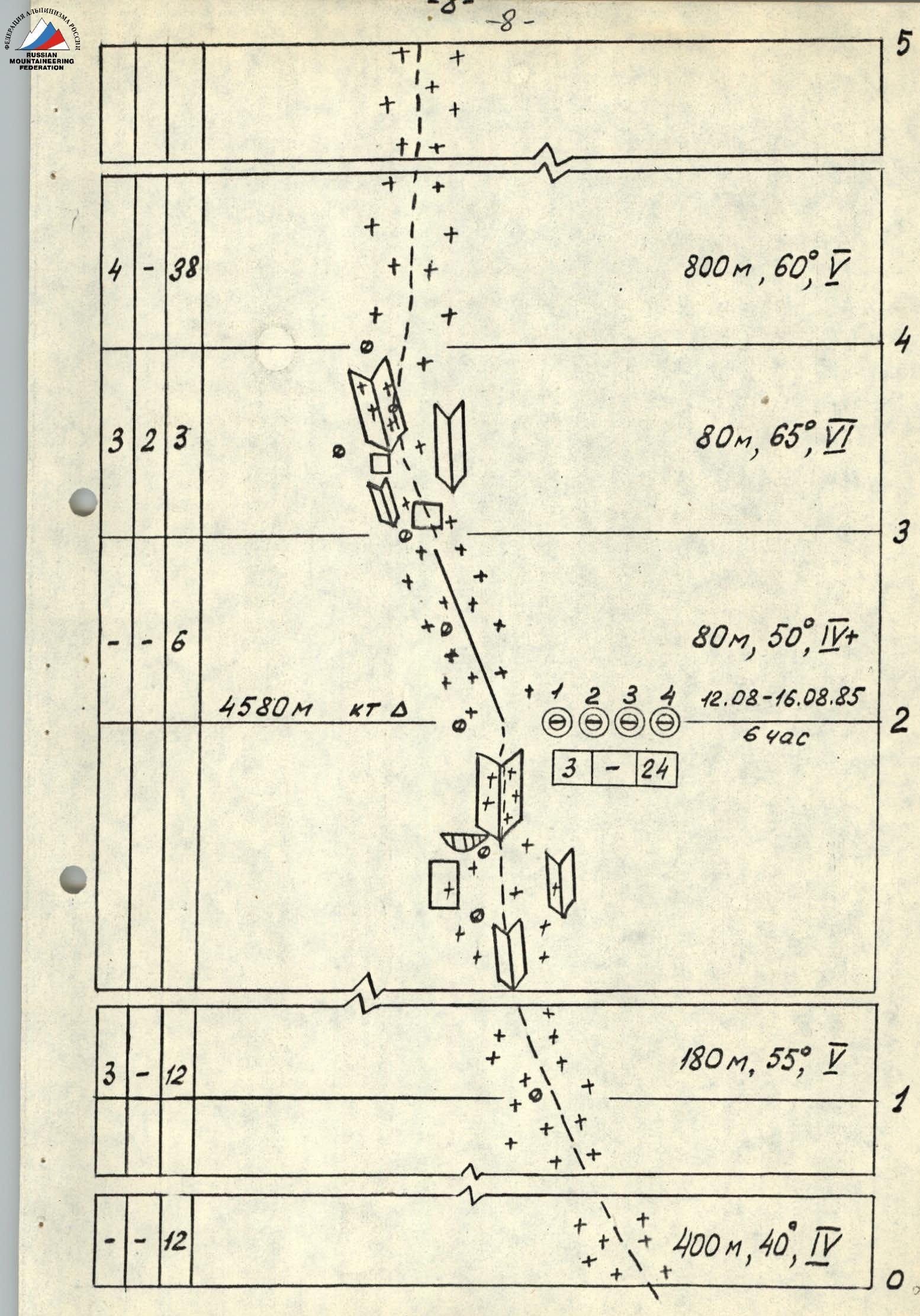
Description of the route by sections
Section R0-R1. Snowy, then icy slope with avalanche debris in the lower part (deep snow), slope up to 45° in the upper part.
Section R1-R2. Ice with rock outcrops covered with ice. Ice screws rest against rocks, do not go in fully. Shortened ice screws work well. Overnight stay on a snowy ridge, lying down. Below the overnight stay, a control cairn is set up on a rocky ridge.
Section R2-R4. From the overnight stay along the snowy rocks of the ridge to the left upwards, exit to the icy slope and along it 120 m under the wall 10 m. Icy, destroyed rocks. It is very difficult to find a place to hammer in a reliable piton.
Section R4-R5. Icy slope, slope 50-55°. In some places — outcrops of destroyed rocks covered with a layer of porous, fragile ice, which has to be chipped away in search of a place to hammer in a rock piton. Long rock pitons made of "hard steel" help, which "hold" in ice-bound, destroyed rocks. We use "ice axe hooks".
Section R5-R6. Bypass of rock outcrops. Ice screws go in with great difficulty and not fully (rest against rock). Ice under a layer of snow up to 30 cm.
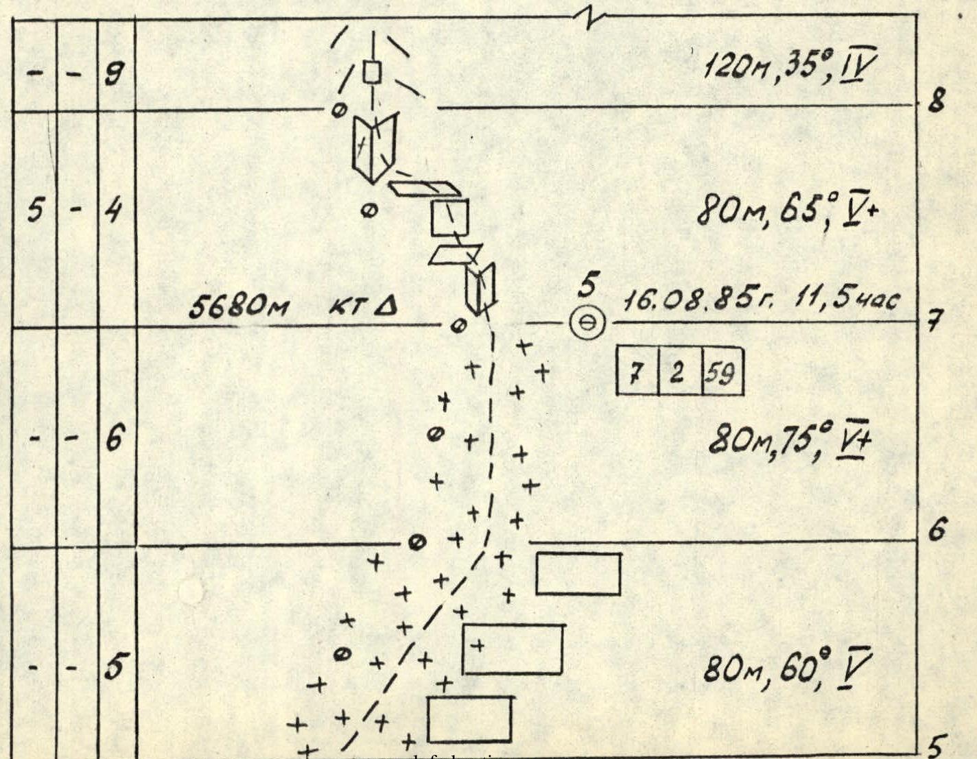
Section R6-R7. Steep, polished, very hard ice. Chips off under crampons and ice axe like lenses. In the upper part — snow-covered firn. Exit to the ridge. Overnight stay on a platform in a small depression. Here, on the rocky ridge, is the second control point.
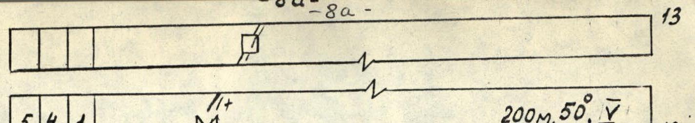
Section R7-R9. From the overnight stay — exit to the ridge along an icy couloir 20 m (hard, smooth ice), then along the ridge.
Section R9-R11. A series of steep walls on the ridge. Rocks are unstable, bound by ice. Further 200 m — a simple ridge. Overnight stay on a scree ridge, lying down.
Section R13-R14. Internal corner, icy, composed of complex, destroyed rocks. It has a series of small walls. Handholds have to be chipped out under the snow; belaying is difficult due to the destroyed rocks.
Section R14-R15. Internal corner, with a shelf, ending in a chimney leading to the snowy summit dome.
The descent along the E ridge to the saddle with Peak Khan-Tengri requires increased attention due to the cornices hanging from the ridge to the north.