
Ascent Passport
- Class of high-altitude ascents
- Tian Shan, Tengri Tag ridge
- Peak Khan Tengri via NE edge of p. Chapayeva's shoulder;
- Difficulty category — 5B.
- Elevation gain — 2910 m.
Distance 6160 m. Distance of sections with V difficulty category 960 m. Average steepness of the main part of the route 40°.
- Team's travel hours — 18, days — 3.
- Overnights: 1 — in a cave, at an altitude of 5600 m, 2 — in a cave on the col, at an altitude of 5950 m.
- Leader:
Moiseev Alexander Anatolyevich, Master of Sports, 344095, Rostov-on-Don, Shtakhanovskogo, 20, apt. 614. Team members: Pogorelov Alexander Grigoryevich, International Master of Sports; Koshelenko Yuri Vladimirovich, Master of Sports; Kolisnyk Vasily Vladimirovich, Candidate for Master of Sports; Fedorchenko Roman Viktorovich, Candidate for Master of Sports;
- Senior coach:
Pogorelov Alexander Grigoryevich, International Master of Sports; 344093, Rostov-on-Don, Lenina, 251, apt. 68
-
Departure to the route: August 24, 1996. Summit: August 26, 1996. Return to base camp: August 27, 1996.
-
Federation of Alpinism and Rock Climbing of the Rostov Region, 344028, Rostov-on-Don, 1st Konnaia Armiya St., 4.

General Photo of the Summit
Taken from the North Inylchek glacier Lens "Industar-61" f = 50 mm. Distance to the wall 4.5 km. H = 3300 m.
- 1 – Khudyakov's route, 1971, N buttress of S wall
- 5 – Myslovsky's route, 1974, center of S wall
- 2 – Gorbenko's route, 1987, S wall
- 6 – Koroteev's route, 1986, center of S wall
- 3 – Pogorelov's route, 1993, left part of S wall
- 7 – Moiseev's route, 1988, right part of E wall
- 4 – Studenin's route, 1974, center of S wall
- 8 – route of the team from the Rostov Region Federation of Alpinism and Rock Climbing, 1996.
Brief Geographical Overview of the Ascent Area
Peak Khan Tengri (7010 m) is located in the Tengri Tag ridge of the central Tian Shan. The area where it is situated represents a node of the highest elevations of the entire Tian Shan mountain system. Here are located peaks:
- Peak Pobeda (7439 m),
- Peak Voennykh Topografov (6870 m),
- Peak Druzhby (6800 m),
- Peak Pogrebetskogo (6527 m), and others. Significant heights in the area act as a barrier to air masses, so Tengri Tag and nearby ridges, Kokshaal-Tau and Meridionalny, form a node with the largest glaciation of the entire Tian Shan system. The area is characterized by cold, unstable weather with a large amount of precipitation.
To the north of the Tengri Tag ridge lies the Sary-Jaz ridge, which has a significant extent. The ridges are separated by the North Inylchek glacier.
To the south of the Tengri Tag ridge lies the Kokshaal-Tau ridge with the highest peak in Tian Shan — Peak Pobeda. Its northern slopes descend to the Zvezdochka glacier.
The area is well-developed for alpinists. The base camp is located on the lateral moraine of the North Inylchek glacier. Helicopter delivery is possible from:
- Karkara,
- Bayankol, or
- Maydaadyr. Flight time – 35–40 min.
Peak Khan Tengri drops off to the north and east with walls with an elevation gain of more than 2500 m. From the west and east, two steep ridges lead to it, and from the south and southwest, it is bounded by steep slopes with two edges, one of which (south-southwest) drops off with a one-and-a-half-kilometer wall. 18 routes have been laid to the summit. Neighboring peaks in the ridge:
- to the west, Peak Chapayeva (6371 m)
- to the east, Peak 6200 (Saldina). The approach to the route from the base camp takes 40 min.
Tactical Actions of the Team
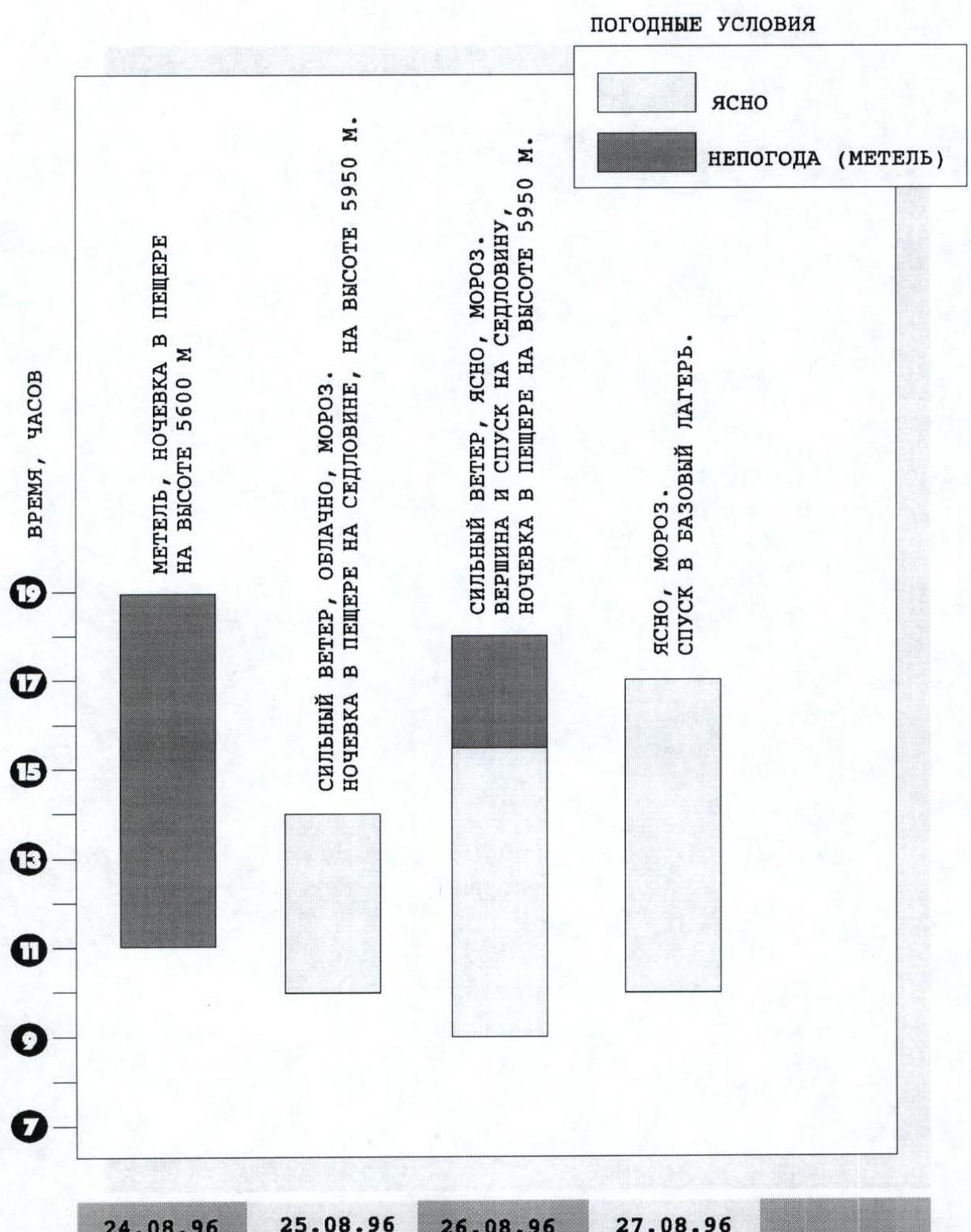
Overall, the ascent was made according to the tactical plan, although on the day of departure the weather worsened again and the whole day was bad weather. This could have again disrupted the ascent, as had happened several times during the stay on the glacier. Nevertheless, the task of the first day was accomplished, the group climbed to an altitude of 5600 m and spent the night in a cave.
On the second day of the ascent, in strong winds that blew snow off the ridge, the team climbed to the shoulder of Peak Chapayeva, 6250 m, and descended to the col between Peak Chapayeva and Peak Khan Tengri (5950 m), where a cave was dug. The task of the second day was accomplished.
On the third day, the ascent to Peak Khan Tengri was planned. In hurricane-force winds, the team made the ascent and descended to the col (5950 m).
On the next day, at 9:00, the descent to the base camp began.
Time Worked on the Route
August 24, 1996 — 11:00–19:00 August 25, 1996 — 10:00–14:00 August 26, 1996 — 9:00–14:30 (summit) — 17:30 (descent to the col)
Ascent Schedule
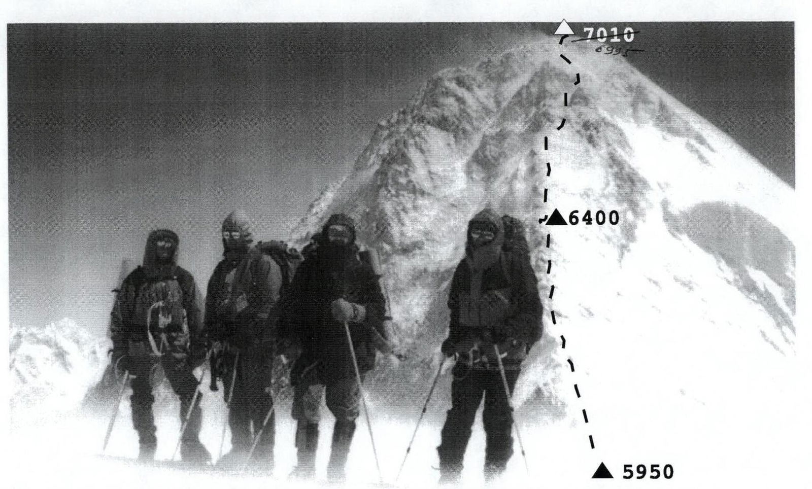
General Photo of the Route on the Section 5950–7010
Taken from the shoulder of Peak Chapayeva, 6250 m. Lens "Industar-61" f = 50 mm.