
Ascent Passport
- Class of high-altitude technical ascents.
- Region 7.9, Tian-Shan, Tengri-Tag ridge.
- Khan-Tengri peak via the W ridge from Semenovsky glacier (variant of M. Pogrebetsky's route-31 via the SW slope).
- 5A category of route complexity, combined.
- Height difference 1400 m, average steepness of the ridge 40°, route length 3000 m. Sections of 1st category of difficulty – 1100 m, 2nd category – 350 m, 3rd category – 1300 m, 4th category – 200 m, 5th category – 50 m.
- Used previously fixed ropes – 700 m, total 1200 m of ropes on the route from 6100 m to 6850 m.
- Climbing hours — 9, days — 2.
- Overnight stay in a snow cave under the col between Chapayev peak and Khan-Tengri peak, 5850 m.
- Dorro Konstantin Eduardovich — CMS, Shanavazov Shanavaz Eldarovich — CMS
- Coach: Murtazaliev Ziyabutin Murtazalievich — 1st sports category.
- Departure from Base Camp — August 9, 1996. Summit — August 10, 1996. Return — August 11, 1996.
- Dagestan Search and Rescue Service, EMERCOM of Russia.
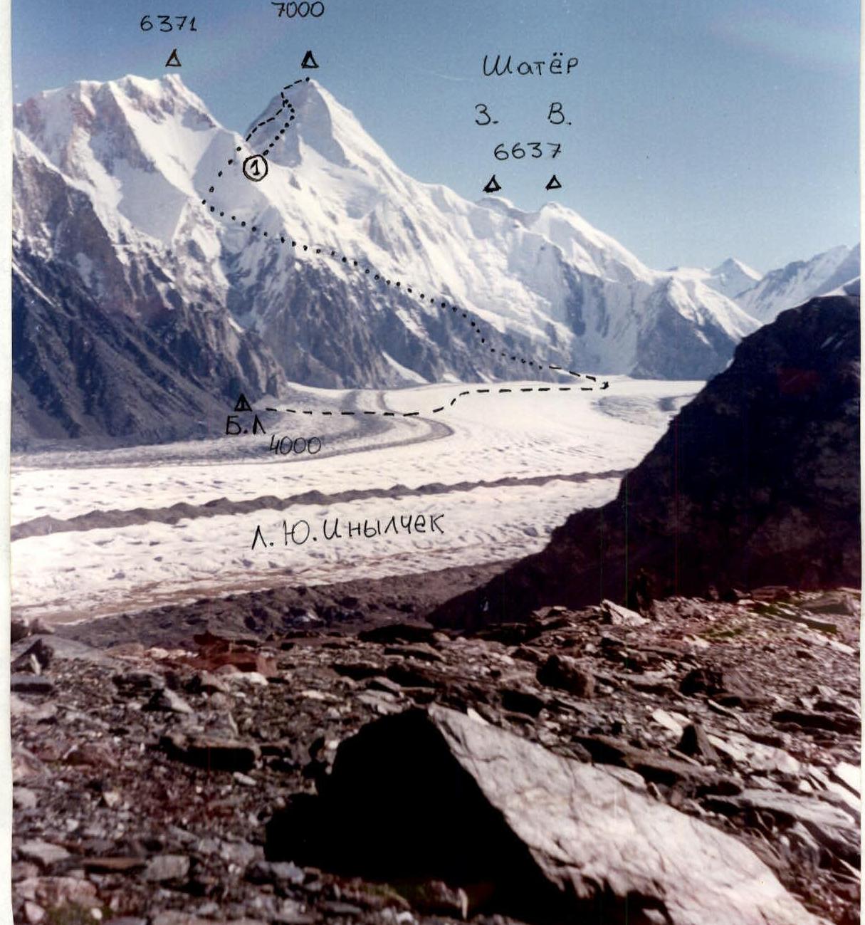
Photo 0 — general view of Khan-Tengri peak (7000 m). Approach route and ascent route, profile of the upper part of the route, from Semenovsky glacier and along the W ridge — 5A category of complexity. Panorama of the ascent area. — M. Pogrebetsky's route-31. Photo taken on August 14, 1995, 10:00 from the E slope of Pesni Abaya glacier at an altitude of 4400 m.
Tactical Actions of the Team
The team of two is making a high-altitude ascent for the first time, although team members participated in joint ascents to Korzhenevskaya peak (unsuccessful) and Engels peak. Dorro had previously made three ascents to Khan-Tengri peak.
The plan was to make a more complex ascent within the framework of the championship, but work at MTAC "Tian-Shan" and bad weather from August 10, 1996 to August 23, 1996 did not allow them to tackle a more serious route.
Based on the experience of previous ascents, the tactical plan was to complete the approach and route with one overnight stay, and the second — after the ascent, on the descent.
They left the base at 5:00 am, crossing South Inylchek and Semenovsky glaciers, and approached the start of the route at 11:00. They walked unroped but carried a rope (30 m, 9 mm, MAMMUT). By 13:00 they were in a cave dug during previous acclimatization outings. Then they rested and spent the night.
They left the cave at 8:00. They moved in crampons, unroped. Around 6100 m, they started using fixed ropes, and about a third of the way, they walked without clipping into the ropes.
At the 6400 m plateau — rest, snack. They traveled lightly, carrying:
- thermos with tea
- food
- crampons
- ice axe
- trekking poles
- in their backpacks — a gortex suit
After traversing, they exited through a wall into a couloir and then to the ridge. A particularly unpleasant section was the poor fixed ropes.
They approached the dome — poor, loose snow. When they reached the pre-summit ridge, they left their backpacks and ice axes and, with trekking poles, reached the summit. They did not find a note.
The weather was very bad: strong wind, no visibility, snow. On the summit, they met Kazakh climbers.
The descent to the cave took 4 hours. The next day, they left the cave at 7:00 and were back at base by 12:00.
Completing the route from cave to cave in 11 hours was a good result.
The ascent was complicated by:
- bad weather
- slushy snow on the approach and descent
- unreliable bridges after warm nights
UIAA symbol scheme: Khan-Tengri peak, via W ridge from Semenovsky glacier, 5A category of complexity.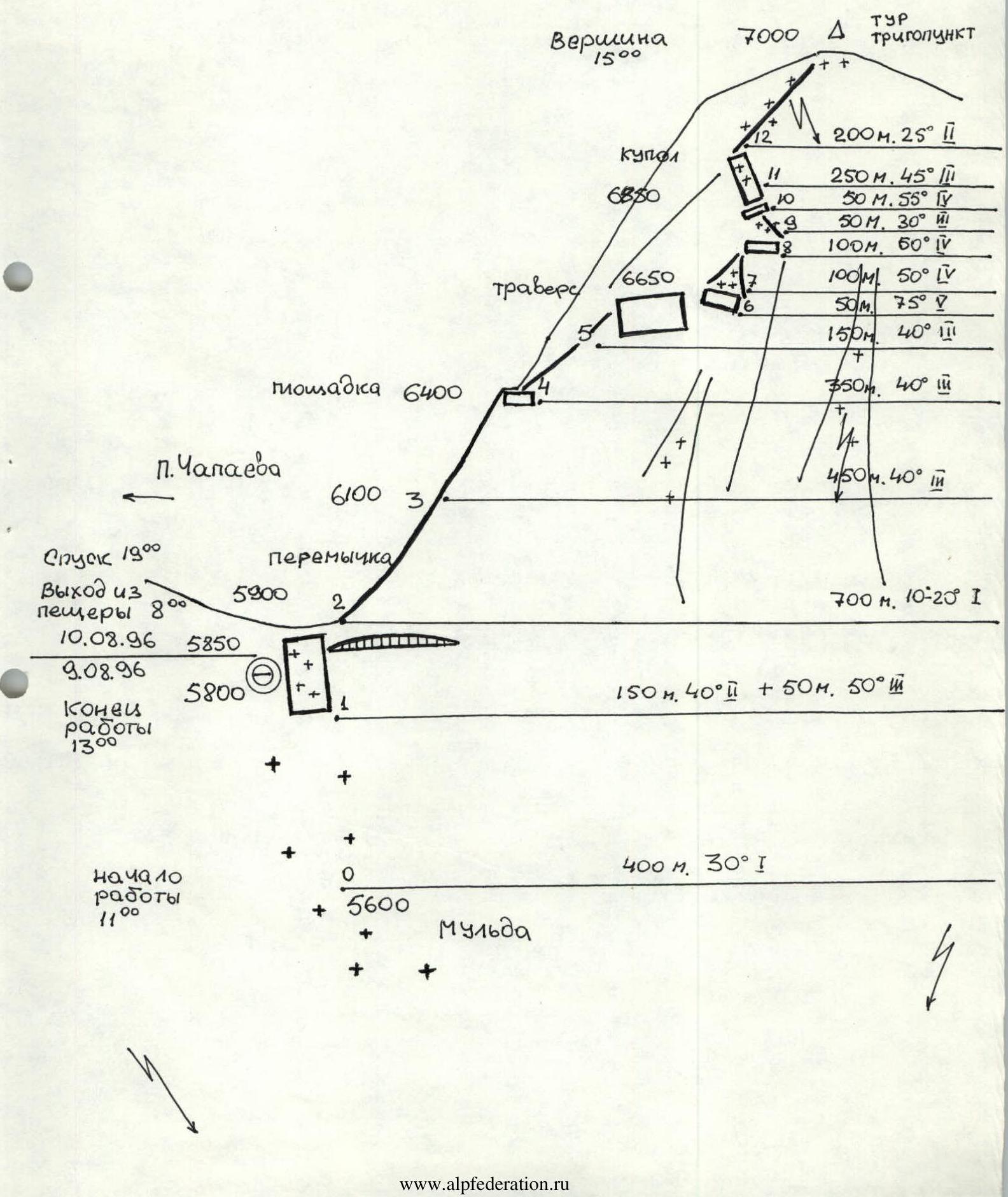
Route Description
The route begins in a depression at 5600 m. The first 400 m — a snowy slope leading to the base of the col. To the left of the bergschrund — caves (have a shovel after snowfall). Overnight stays are comfortable.
From the cave, ascend a steep slope to the col (better to fix a rope on the descent). On the col, at 5900 m, turn right and along a snowy ridge (attention: left side has cornices!) with two rock steps, reach the start of the fixed ropes.
Further:
- through slabs and numerous walls, reach the 6400 m camp site (3 hours), possible bivouac;
- continue along the walls and slabs of the W ridge to approach the summit tower, 6700 m.
Along the entire W ridge, it is possible to walk without fixed ropes and, in places, to bypass rock steps on the right via slabs. Before the tower — a traverse with a gain in height to the right. Through a complex wall, enter a couloir.
Attention! Careful work on fixed ropes is required. Steepness increases, the couloir is blocked by a wall, under which — a traverse to the right. Very poor fixed ropes.
Exit onto a snowy ridge and along it to the left. Through large-blocky rocks and slabs of a rock step, reach a snowy slope-dome. In places, old rope is visible among the snow. Steepness increases (attention! on the descent, be cautious, use ice axe and crampons).
Upon reaching the pre-summit ridge, turn right and, bypassing rock blocks on the left, reach the summit — a trigonometric point. 4 hours from 6400 m.
Descent along the ascent route to the cave takes 4 hours.
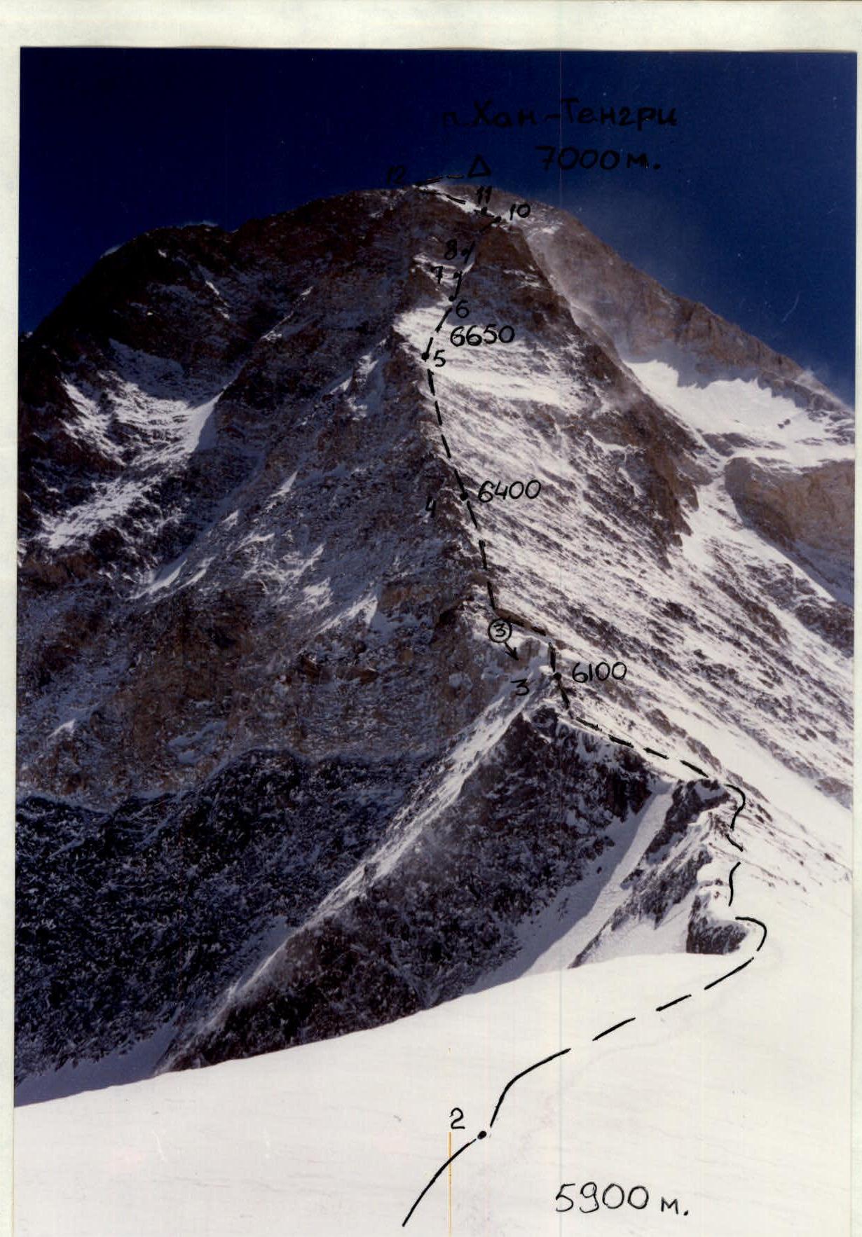
Photo 1. Technical photograph of the route:
- Shot from the col.
- Date: August 1, 1996, 11:00.
- Exposure 8 m.
- Kodak-100 and further.
 ≠ 0 m
≠ 0 m
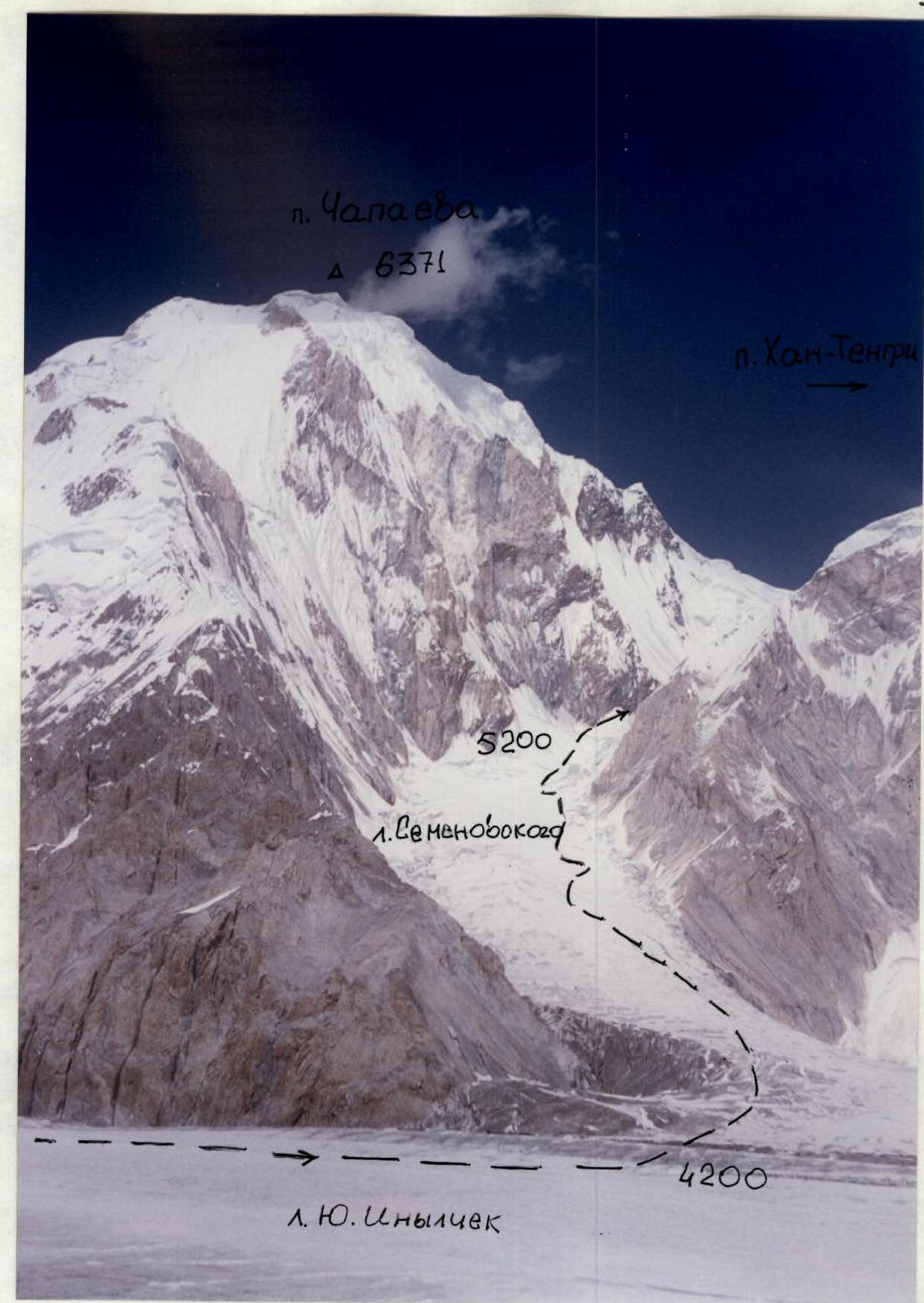
Photo 2. Approach to the route, shot from a Mi-8MTV flyover, altitude 4300 m, August 4, 1996, 11:00.