Passport
- High-altitude class
- Central Tian-Shan, South Inylchek Glacier
- Peak Khan-Tengri via the southwest slope (Pogrebetsky route)
- Category 5B difficulty
- Elevation gain — 1095 m, length — 1700 m (main part of the route). Total elevation gain — 2595 m. Length of category 5 sections — 590 m. Average steepness of the main part of the route 45°, category 5 sections — 55°–60° (6700–6850 m). Pitons used: Rock — 52, bolt — 0, chocks — 16, ice — 5.
- Team's travel hours: 18, days — 3.
- Overnight stays:
- Cave dug in a snow-firn slope — 5900 m.
- Platform on a snowy ridge — 6700 m.
- Platform on a snowy ridge — 6400 m.
- Leader: Yuri Vasilyevich Sannikov, CMS.
Participants:
- Gennadiy Nikolayevich Volkov, CMS.
- Yuri Aleksandrovich Kazakov, CMS.
- Igor Yevgenyevich Kolesnikov, CMS.
- Viktor Aleksandrovich Zaitsev, CMS.
- Igor Leonidovich Pavlov, CMS.
- Coach — Nikolai Nikolayevich Dyachenko.
- Departure to the route: August 9, 1987. Summit: August 11, 1987. Return: August 12, 1987.
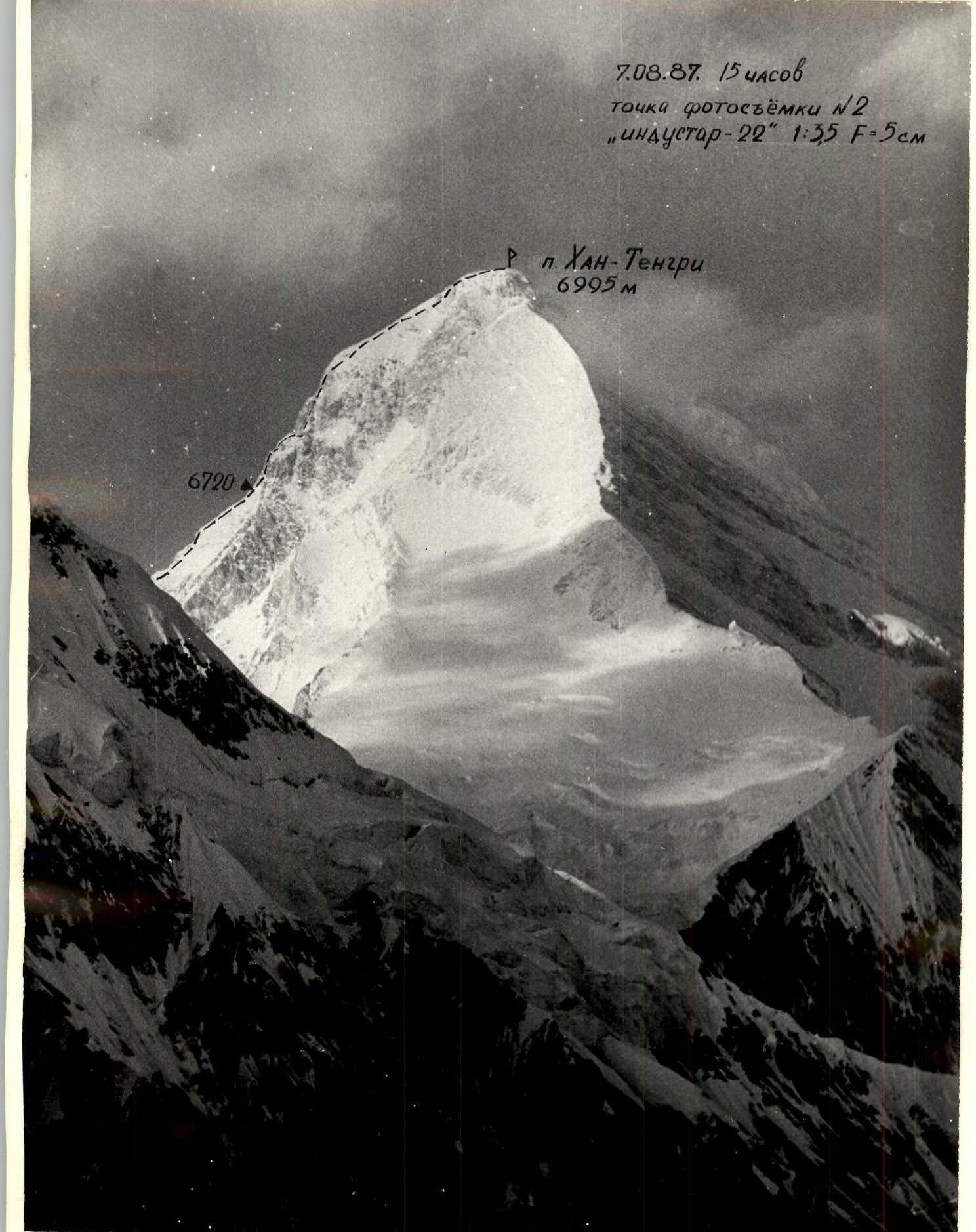
August 7, 1987, 15:00. Photo point #2: "Industar-22" 1:35 F=5 cm. Peak Khan-Tengri, 6995 m.
Tactical Actions of the Team
When compiling the tactical plan for the ascent, the team was guided by the possibility of organizing movement along the route sections without preliminary processing of the path from bivouac to bivouac. Preliminary processing of the route, unlike the tactical plan's provision for the interaction of rope teams, was applied only on the section above 6700 m, where the team arrived at 16:00 and, meeting a group descending from the summit, set up camp for the night.
While the main part of the team prepared a platform for the tent, the Volkov—Kazakov rope team processed 2 ropes for the further path.
The next day, up to a height of 6850 m, the Kolesnikov—Pavlov rope team worked ahead. In accordance with the tactical plan, the team moved with the interaction of rope teams.
Since the team members were practically equal, no special attention was paid to the order of the rope teams, as the speed of movement did not depend on which team was leading.
Thus, on the sections:
- 5900–6700 — Volkov—Kazakov;
- 6700–6850 — Kolesnikov—Pavlov;
- 6850–6995 — Sannikov—Zaitsev.
The time regime for departure and organization of overnight stays was strictly observed by the team. The nutrition regimen provided for:
- two hot meals a day with plenty of drinking water;
- individual rations for snacks during work on the route.
The ascent plan by days was fulfilled. There are quite a few good places for organizing overnight stays on the route:
- the first platform (6700 m) was trampled on a snowy ridge;
- the second platform (6400 m) — on the descent;
- at a height of 5900 m, they spent the night in a snow cave.
Belays on the route were provided using:
- rock pitons;
- chock stones.
The terrain of the route and clear weather allowed the team to be observed throughout the entire path. Communication was carried out using "Tulip" radios.
| Section # | Rock Pitons | Chocks | Bolt Pitons | Ice Pitons | Section Diagram | Difficulty Category | Length (m) | Steepness (°) | Notes |
|---|---|---|---|---|---|---|---|---|---|
| 1 | 4 | 1 | - | - | (see diagram) | 4 | 7 | 50 | |
| 2 | 4 | 2 | - | - | (see diagram) | 4–5 | 70 | 45 | |
| 3 | 3 | 2 | - | - | (see diagram) | 5 | 65 | 55 | |
| 4 | 6 | - | - | - | (see diagram) | 4–5 | 190 | 45 | |
| 5 | - | - | - | - | (see diagram) | 3–4 | 380 | 40 | |
| 6 | - | - | - | - | (see diagram) | 3 | 190 | 35 | 475 m, 27 pitons, travel hours — 4. Section not to scale. |
| 7 | 7 | 3 | - | - | (see diagram) | 5 | 55 | 55 | |
| 8 | - | - | - | - | (see diagram) | 4 | 85 | 45 | |
| 9 | 12 | 5 | - | - | (see diagram) | 5 | 145 | 60 | Overnight stay, travel hours — 9, 46 pitons, 1225 m. |
| 10 | 3 | 1 | - | - | (see diagram) | 3 | 155 | 40 | |
| 11 | 4 | - | - | 5 | (see diagram) | 5 | 100 | 45 | |
| 12 | 9 | 2 | - | - | (see diagram) | 6 | 65 | 45 | |
| 13 | - | - | - | - | (see diagram) | 5 | 145 | 45 |
Total: travel hours — 13, pitons — 73.
Description of the Route by Sections
- From the foot of Peak Khan-Tengri (4500 m) to the saddle between Peaks Chapayev and Khan-Tengri (6000 m), the route passes along the Semenovsky Glacier. In the middle (by height) part, the glacier is heavily crevassed, movement in rope teams. The slopes of Peak Chapayev and Peak Khan-Tengri are avalanche-prone, so the ascent to the saddle must be conducted at a rapid pace and early passage of the most dangerous section (4700–5600 m). Technically, the section (4500–6000 m) corresponds to category 2–3 difficulty, but requires significant physical effort.
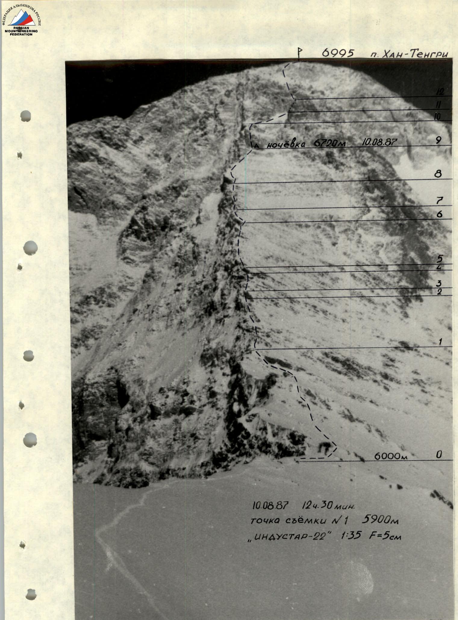
- The route directly begins at a height of 6000 m (saddle). The section 6000–6400 m — a snow-firn slope with outcrops of heavily destroyed rocks, average steepness 40°.
- The section 6400–6700 m passes along the edge of the southwest slope, which drops steeply towards the North Inylchek Glacier. This section is a heavily snow-covered rock slope with a steepness of 45°.
- The most technically difficult section is at a height of 6700–6850 m, with an average steepness of 55–60° and individual (10–20 m) rock walls. Passing this section requires increased attention and thorough piton belays.
- The ascent to the summit is along a snow-firn slope with rare rock outcrops, does not present technical difficulties for passage, and corresponds to category 3 difficulty.
A feature of the entire route is its combined nature and increasing technical difficulty with height.
- August 9, 1987 — departure from the camp at 4400 m and ascent to the saddle, overnight stay in a snow cave (5900 m).
- August 10, 1987 — departure directly onto the route along the southwest slope of Peak Khan-Tengri. Simultaneous movement in rope teams along a rocky snow-covered slope, initially bypassing individual rock outcrops, then through rocky sections. The Volkov—Kazakov rope team works ahead, belaying with pitons and using chock stones. Arrival at the site for organizing an overnight stay at 6700 m and processing the route above the overnight stay.
- August 11, 1987 — the Kolesnikov—Pavlov rope team works ahead. Movement along snow-covered destroyed rocks. Organization of rope belays. Piton belays, using chock stones is possible only after clearing rocks from snow. Ascent to a firn ridge. The Sannikov—Zaitsev rope team leads, moving simultaneously with intermittent belays along the ridge. In places, there are small (5–10 m) outcrops of destroyed rocks. Ascent to the summit along a snow-covered dome.
Peak Khan-Tengri, 6995 m. Overnight stay at 6720 m on August 10, 1987.
August 10, 1987, 12:30. Photo point #1: 5900 m, "Industar-22" 1:35 F=5 cm.