п. Petrovsky, via the SW wall – ZheSTKOV V.A. Tien Shan 7.9.
Passport
- Class: High-altitude technical
- Tien Shan, Tengri-Tag ridge
- Peak Petrovsky via the SOUTHWEST wall
- Proposed 6A category of difficulty. First ascent
- Elevation gain: 1460 m. Route length – 1950 m.
Length of sections with 6A and 6B category of difficulty – 260 m. Average steepness of the main part of the route 63° (4400–5595)
- Pitons left on the route (not removed) – 5
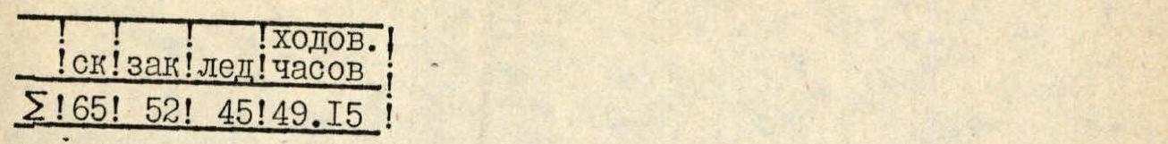
- Team's climbing hours: 49 hours and days – 5
- Overnights: 1st on a platform; 2nd – two standing on a ledge, three sitting on a ledge; 3rd on a platform carved on a snow-ice slope; 4th – snow platform in a rock niche.
- Team leader: ZHESTKOV VLADIMIR ALEKSEEVICH – Candidate Master of Sports
Team members: ZAKHAROV VLADIMIR GEORGIEVICH – Candidate Master of Sports, VOLKOV ANDREY EVGENIEVICH – Candidate Master of Sports, SABELNIKOV ILYA VLADIMIROVICH – Master of Sports of the USSR, BENKIN IGOR VLADIMIROVICH – Master of Sports of the USSR
- Coach: DUSHARIN IVAN TROFIMOVICH – Master of Sports of the USSR.
- Departure to the route: August 5, 1991.
Summit – August 9, 1991. Return – August 10, 1991.
- Organization – SAMARA ALPINE COMMITTEE.
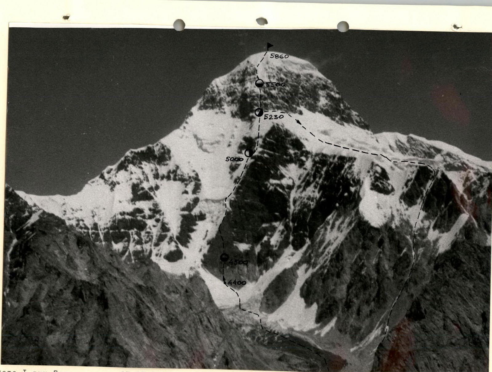
Photo 1. Peak Petrovsky. July 27, 1991, 13:00, Minitar-I, F-32, 2000 m, point 1, altitude 4500 m, taken from a helicopter.

Photo 2. Semi-profile of the upper part of the wall. July 27, 1991, F 32, 4000 m, point 2, altitude 4500 m, taken from a helicopter.
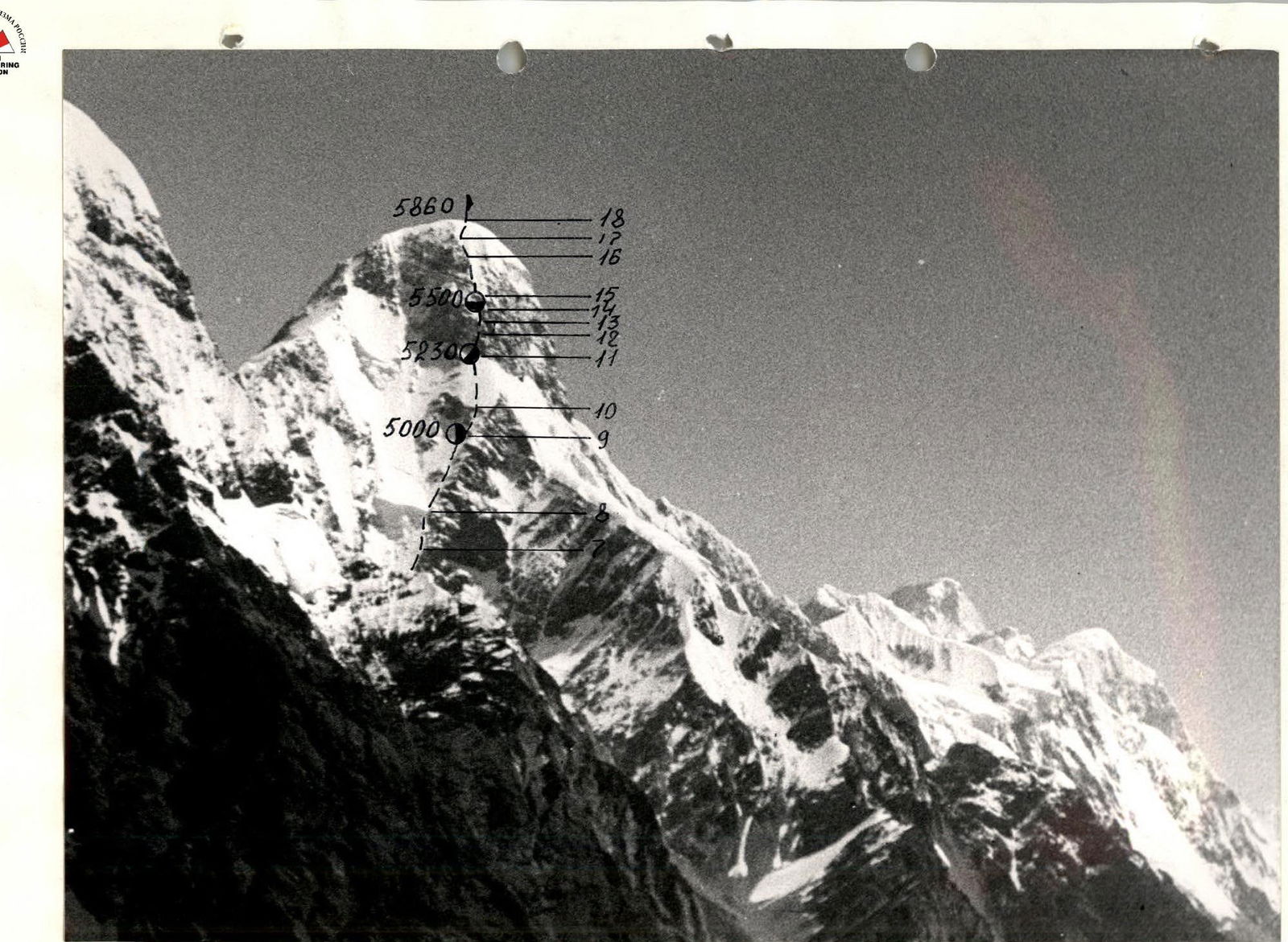
Photo 3. Semi-profile of the upper part of the wall. July 27, 1991, 13:00, Minitar-I, F 32, 4500 m, point 3, altitude 4500 m, taken from a helicopter.
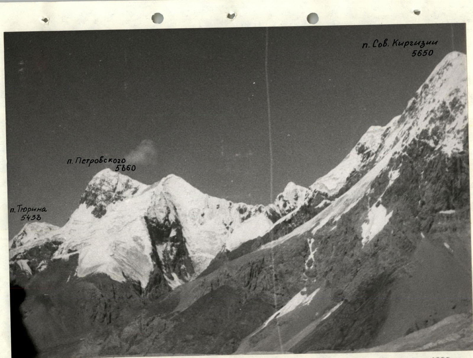
Photo 4. Photopanorama of the area. July 27, 1991, 13:00, Minitar-I, F 32, 9000 m, point 4, altitude 4200 m, taken from a helicopter.

Brief Overview of the Climbing Area
Peak Petrovsky – 5860 m is located in the most visited area of Central Tien Shan in the Tengri-Tag ridge. Starting 15 km from the end of the South Inylchek glacier tongue, the Tengri-Tag ridge stretches in a latitudinal direction for more than 60 km, crossing the Meridionalny ridge on the territory of China. Along with Peak Petrovsky, Tengri-Tag is crowned with such peaks as:
- M. GORKY – 6050 m
- Chapayev – 6371 m
- Khan-Tengri – 6995 m
Currently, hundreds of climbers, both Soviet and foreign, visit the South Inylchek glacier area every year. Most of them arrive by car from the city of Przhevalsk through the Inylchek settlement to the "Maida-Adyr" border post – 4.5–5 hours. Then by helicopter to the camp on the moraine under Peak Gorky or on the moraine of the Zvezdochka glacier.
The most interesting peaks for climbers are:
- Peak Pobeda
- Peak Khan-Tengri
- Peak Petrovsky
Peak Petrovsky, located 18 km west of Peak Khan-Tengri, is not visited by climbers, although it attracts their attention with its bold outlines. Studying mountaineering literature, you won't find data on ascents to this peak.
Geologically, the Tengri-Tag ridge from Peak Bronenosets to Khan-Tengri is composed mainly of sedimentary rocks:
- schists,
- limestones,
- marbles.
In some cases, small granite intrusions are noted, such as in the area of Peak Petrovsky.
The location of the area at 42° north latitude, large glaciation area, and relatively high peaks determine the harsh climatic conditions for climbing. More detailed information on the physical and geographical characteristics of the area can be found in M.E. Grudzinsky's review in the Yearbook of Soviet Mountaineering "Conquered Peaks" for 1954–1957, p. 167.
The approach to the observers' camp on the left moraine of the Tyurin glacier from the base camp on the moraine of the Zvezdochka glacier takes 8–10 hours. From the base camp, crossing the South Inylchek glacier, you need to reach the orographically right lateral moraine of the South Inylchek glacier under the slopes of Peak Gorky, where the MAC "Tien Shan" camp is located. Then follow a clearly marked trail to the Gorky glacier.
After crossing the Gorky glacier, the trail is practically absent, but movement is possible along the lateral moraine, crossing the glaciers:
- Stvor,
- Sovkirgizia,
- Krupskaya.
From the Krupskaya glacier, there is no trail at all, and the approach goes along the right edge of the South Inylchek glacier, sometimes under steeply falling rocks from the spurs of Peak Petrovsky, to the lateral moraine of the Tyurin glacier, where the observers' camp is located. From the observers' tent, the ascent to the Southwest wall of Peak Petrovsky is through the icefall of the Tyurin glacier in its orographically left part.
On the South Inylchek glacier, opposite Peak Petrovsky, a helicopter landing is possible, which shortens the time but can facilitate the organization of the ascent and, if necessary, rescue operations.
Team's Tactical Actions
On August 5 at 8:00, after examining the SW wall of Peak Petrovsky, the pair ZheSTKOV – ZAKHAROV began moving along its left part.
The lower part of the SW wall of Peak Petrovsky is a system of vertical granite blocks with partially overhanging sections. The rocks have few cracks, and the holds are directed downwards.
Three rope lengths from the start of the wall, a protruding rock "finger" was visible, covered from above by an overhanging section of the wall. Having passed three rope lengths to the "finger" using IT, the group organized a bivouac, and the pair ZheSTKOV – ZAKHAROV processed another 2 rope lengths above the "finger" towards the left edge of the wall, as continuing to move towards the center of the wall became problematic.
The nature of the terrain above the "finger":
- the rocks became increasingly destroyed with overhanging sections;
- often ending with 10–15-meter ice icicles;
- alternating with inclined shelves 50–65°, covered in ice.
Organizing reliable belay points became impossible.
On August 6, having passed two processed rope lengths and then three rope lengths of the wall (belay using pitons and chocks with the use of IT, photo 5), the team emerged from under the overhangs onto the left edge of the wall under the icefall. Having moved along the edge for 4 rope lengths (piton belay), they overcame the icefall (ice axe and crampons) and organized a hot snack under an overhanging rock.
Further, bypassing the overhang from the left, they moved along the edge with belay (see UILA scheme), passing another 8 rope lengths. No suitable places for an overnight stay were found during the day. Due to the onset of darkness, they organized a bivouac under an overhanging rock. Three team members spent the night sitting on shelves carved in the ice, and two standing on belay points.
On August 7, starting to move at 4:00, by 10:00, having passed 8 rope lengths, they approached under a vertical tower. Here, they organized belay points and carved out a platform for a semi-reclining overnight stay. After lunch, the pair VOLKOV – ZAKHAROV processed three rope lengths of the summit tower. The rocks were snow-covered. Overnight stay.
Weather conditions:
- snow is falling in the evening;
- fog is observed.
On August 8, departing at 7:00 and passing the belay points, then 5 rope lengths (photos 5, 6, 7), they reached a niche formed by two rock slabs. Overnight stay. The pair VOLKOV – SABELNIKOV worked on 3 rope lengths above the niche.
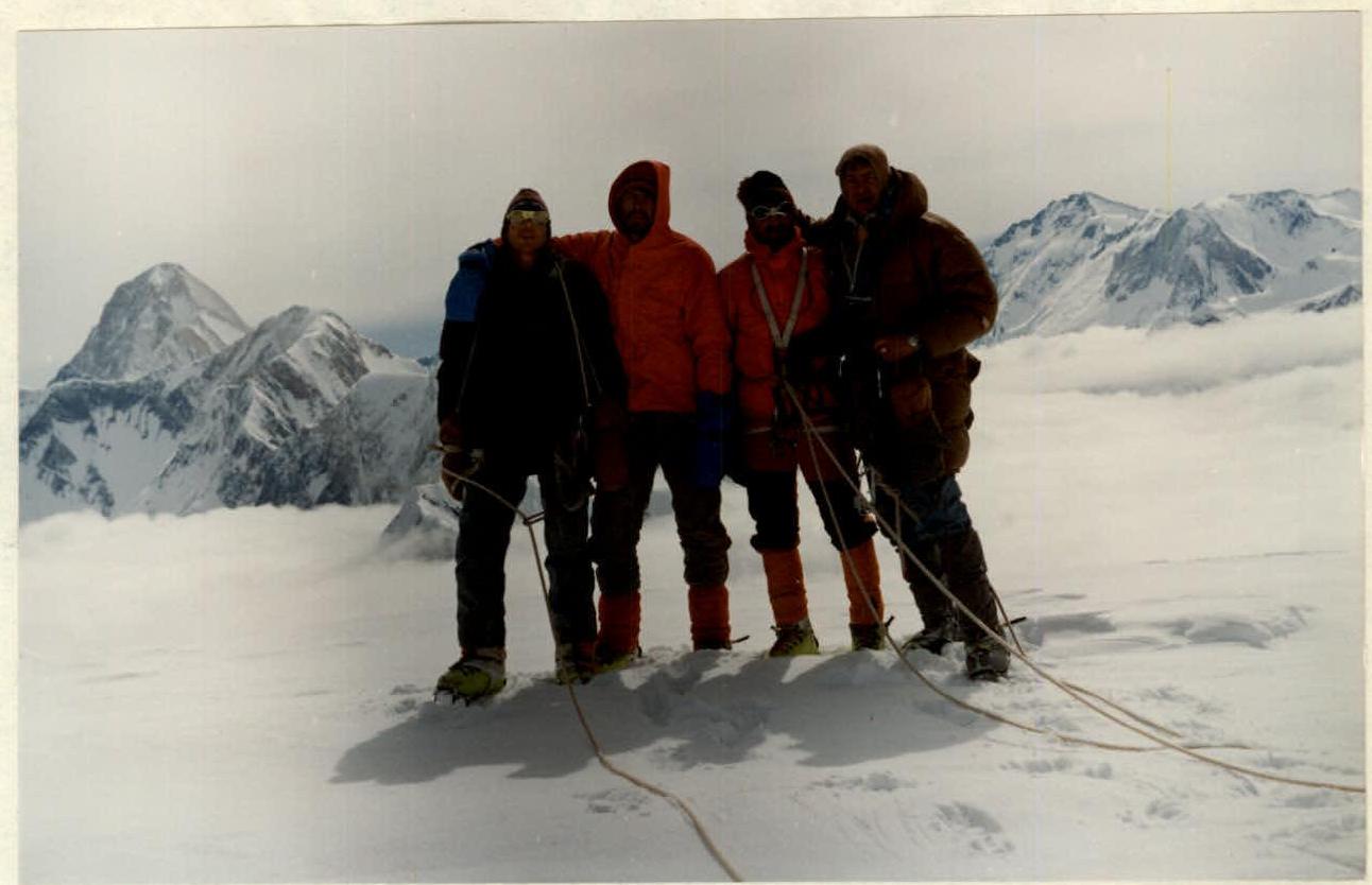
On August 9, departing at 6:00, they passed the belay points, and then along the snow-ice cap, they reached the summit (photos 9, 10, 11). The summit dome resembles the summit of Peak Khan-Tengri. No control cairn was found on the summit of Peak Petrovsky. They began their descent from the summit at 9:00, leaving a note in a cairn built on a rock island 80 m below the summit on the SW slope.
During the ascent, the team maintained regular radio communication with observers and through them with the base camp, where a rescue team was located. Members of the rescue team underwent acclimatization by making an ascent to 6000 m.
The ascent was provided with sufficient food supplies (see table).
Table of food and fuel supplies
| Name | Quantity (kg) |
|---|---|
| 1. Fried meat | 1 |
| 2. Smoked fat | 0.5 |
| 3. Cold-smoked sausage | 0.7 |
| 4. Freeze-dried shrimp | 0.4 |
| 5. Cottage cheese | 0.3 |
| 6. Buckwheat porridge | 0.5 |
| 7. Blackcurrant juice | 0.4 |
| 8. Condensed milk | 0.4 |
| 9. Dry milk | 0.4 |
| 10. Dried fish | 0.3 |
| 11.18 Instant coffee | 0.05 |
| 12. Tea | 0.1 |
| 13. Chocolate | 0.5 |
| 14. Sugar | 0.5 |
| 15. Bee honey | 0.1 |
| 16. Pocket food: nuts, raisins, apricots in sugar | 1.5 |
| 17. Garlic, onion | 0.1 |
| 18. Crackers | 1.0 |
| Total weight of products | 8.65 kg |
| Petrol | 3.5 l |
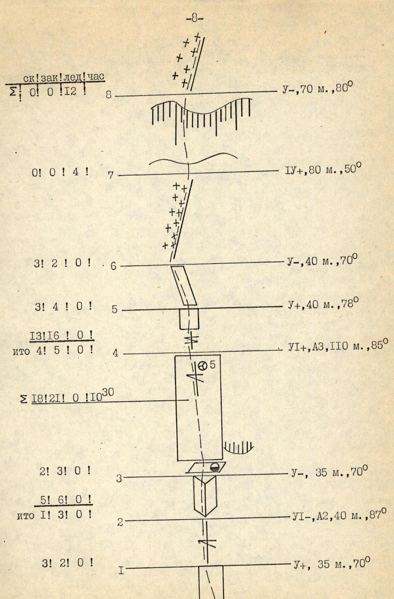
Scheme of the route M 1:20000
 www.alpfederation.ru↗
 www.alpfederation.ru↗
From the observers' tent on the moraine of the Tyurin glacier:
- The approach to the SW wall of Peak Petrovsky takes 1.5 hours.
- Passage through the icefall in its right part in the direction of movement (photo 12).
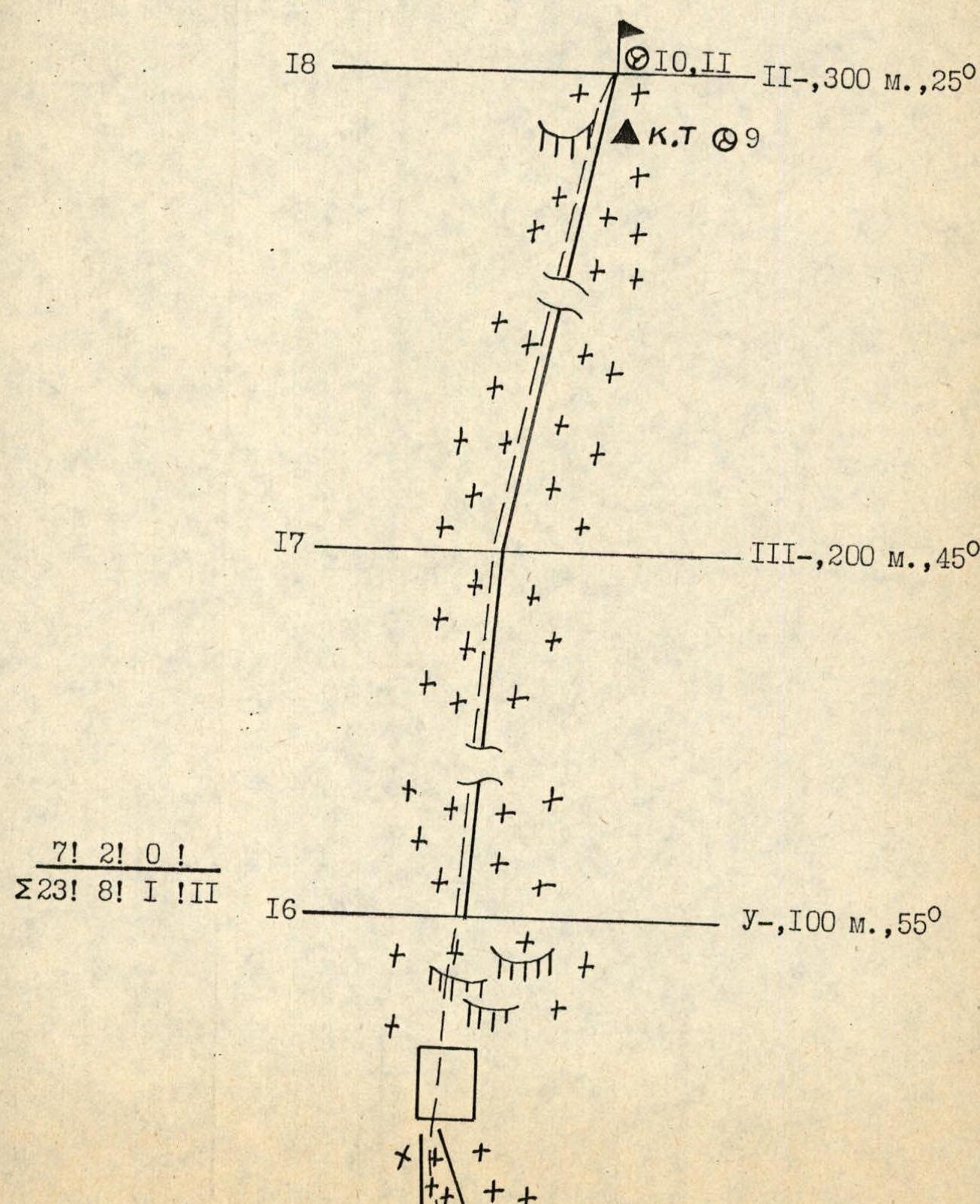
SECTION R0–R1. Passed by free climbing. Climbing is technically difficult. The rocks are firm with few cracks. Belay is reliable through pitons and chocks.
SECTION R1–R2. 40 meters of very difficult climbing using IT along a vertical crevice with few holds. Piton belay and chocks. Large chocks and friends are recommended. Movement is directed towards the rock "finger" to the internal corner.
SECTION R2–R3. Exit to the platform behind the rock "finger" along the internal corner with sufficient cracks. Free climbing. Belay:
- reliable through pitons and chocks;
- at the "finger," the rope is attached to a ledge. Behind the "finger" is a convenient place for an overnight stay.
SECTION R3–R4. Represents a rock wall with a series of predominantly vertical cracks, ending in a crevice. Movement starts from the left behind the "finger" upwards to the left towards the crevice. Climbing is difficult using IT. Passing first – only in crampons. Belay:
- through chocks;
- through pitons. To speed up movement, it is recommended to use rope pulls for all team members.
SECTION R4–R5. Initially 20 m along the crevice, and then along a 20-meter wall. Climbing is free. Rocks are more destroyed. Falling rocks are possible. Climbing uses pitons and chocks.
SECTION R5–R6. Rocks are destroyed. Movement is left and upwards with an exit to the left edge. Climbing is difficult, but there are small ledges crossing the wall.
SECTION R6–R7. Represents an ice slope with small rock outcrops. Movement only in crampons. Belay through ice screws.
SECTION R7–R8. Passed along the icefall on front points with the use of ice axe and organization of belay points. The safest passage is along the right part of the icefall with an exit under the overhanging rock wall.
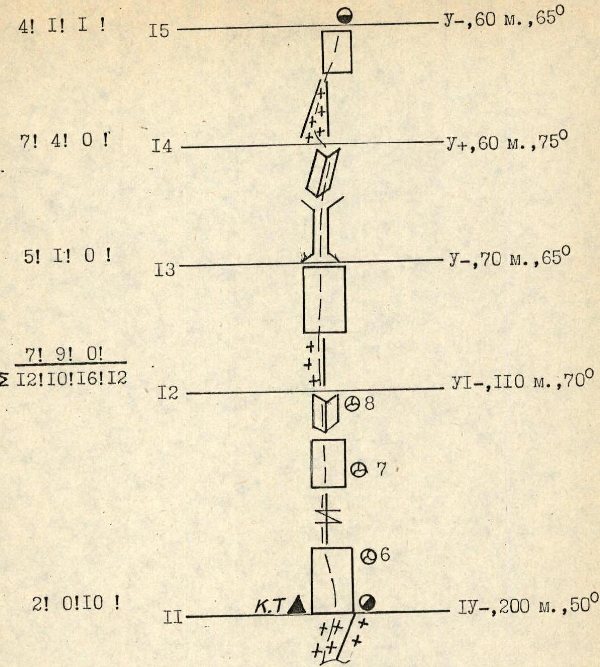
– 10 –
SECTION R8–R9. 300 m of relatively easy ice slope with rock outcrops. Belay through ice screws. Movement involves bypassing rock islands without going left under the overhanging icefall. DANGEROUS! There are no convenient places for overnight stays. Passage involves organizing belay points. The section ends under a rock wall cut by a chimney. Overnight stay:
- three sitting on shelves;
- two standing.
SECTION R9–R10. Starts with a 20-meter chimney, then an ice slope and a rock wall. Passed using rock and ice pitons. There are no major technical difficulties.
SECTION R10–R11. Ice slope with snow, leading to the base of the summit tower. Passage in crampons. Belay through ice screws. Under the summit tower, in the corner of a yellow rock block, a platform is carved out for an overnight stay. Control cairn.
SECTION R11–R12. The most difficult section of the summit tower. Composed of fairly firm rocks, predominantly with vertical cracks. Rocks are snow-covered and partly covered with ice crust. From the control cairn, 15 m to the right, then movement upwards along the wall for 40 m. After the wall, a crevice is passed, leading to the next wall, which ends in an internal corner. The internal corner leads to the summit of the section. Climbing is very difficult. Piton belay, through chocks.
SECTION R12–R13. A small ridge leads to the wall of the next rock bastion of the summit tower. The wall is passed by free climbing. Piton belay.
SECTION R13–R14. From the wall of the previous section, left and upwards into a steep 30 m chimney ending in an internal corner. Climbing is difficult. Belay:
- through pitons;
- chocks;
- organization of belay points.
SECTION R14–R15. Leaving the rock wall to the right, ascent along a snowy couloir under the wall. The wall leads to a characteristic rock niche formed by two rock slabs. In the niche – a snowy drift. Convenient place for an overnight stay.
SECTION R15–R16. From the niche, left and upwards along a snow-covered couloir through a rock wall and a series of rock brows – exit to the summit dome. Belay through pitons and chocks. Belay points.
SECTION R16–R17. Simultaneous movement along a snowy slope with the formation of steps. Passed in pairs, обязательно with ice axes.
– 11 –
SECTION R17–R18. Simple snowy slope leading to the summit. 80 m from the summit – a small rock outcrop, on which a control cairn is built (photo 9).
Descent from the summit follows the ascent route under the base of the summit tower. Here, under the rocks of the summit tower, – traverse towards the SE ridge (5 rope lengths) and 400 m down to the ice pad. Along the ice pad, through ice breaks, to the South ridge. Along the ridge to rocks with a sharp drop in the ridge. From the drop in the ridge – descent to the right into a snowy couloir with a visible turn to the left. Descent is steep, with possible rockfall. Sports descents and rappels are organized. The couloir leads to the orographically left moraine of the Tyurin glacier. Down the moraine to the observers' camp – about 20 minutes.
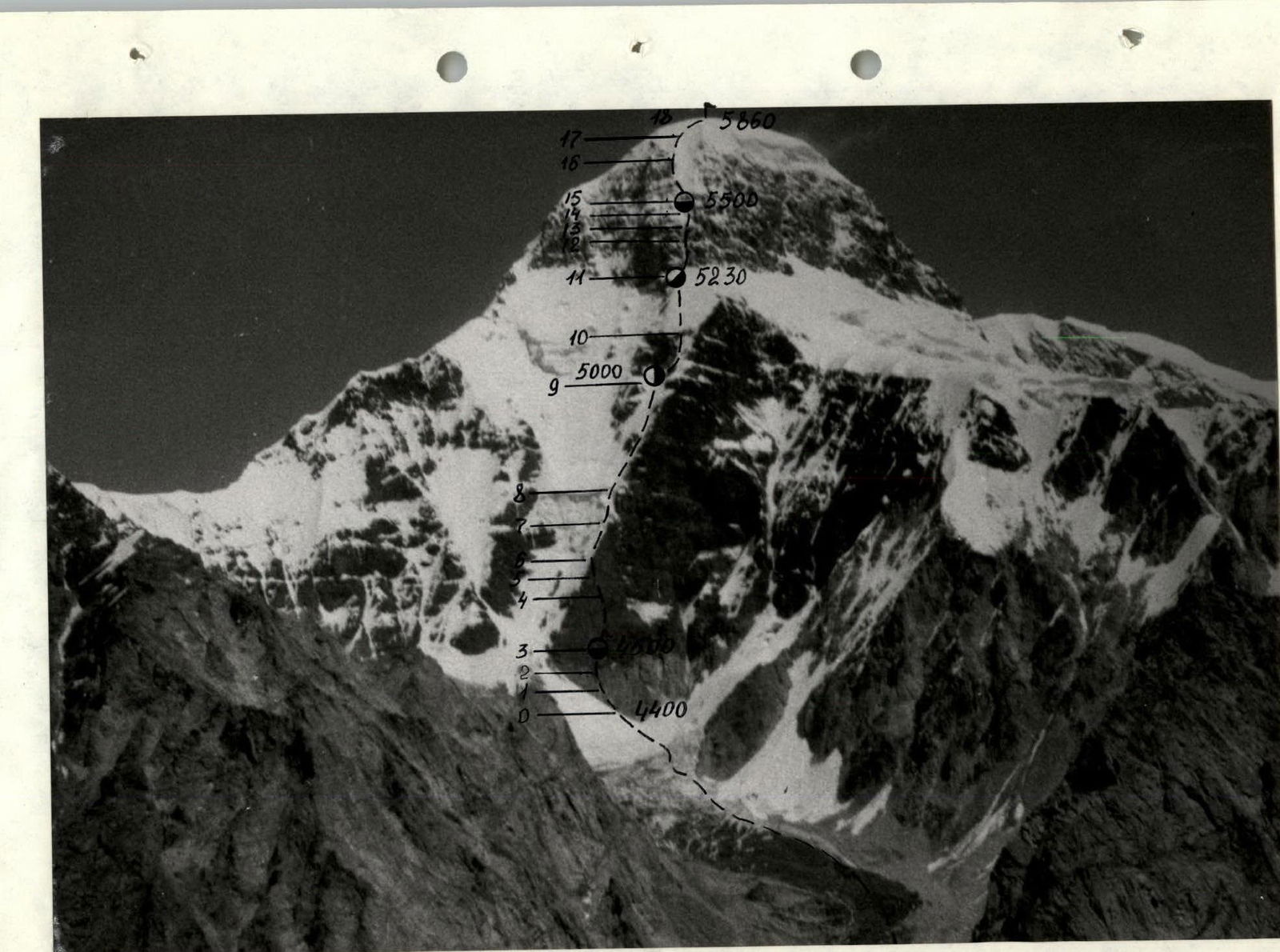
Photo 12. Peak Petrovsky. August 27, 1991, 13:00, Minitar-I, F 32, 2000 m, point 1, altitude 4500 m, taken from a helicopter.
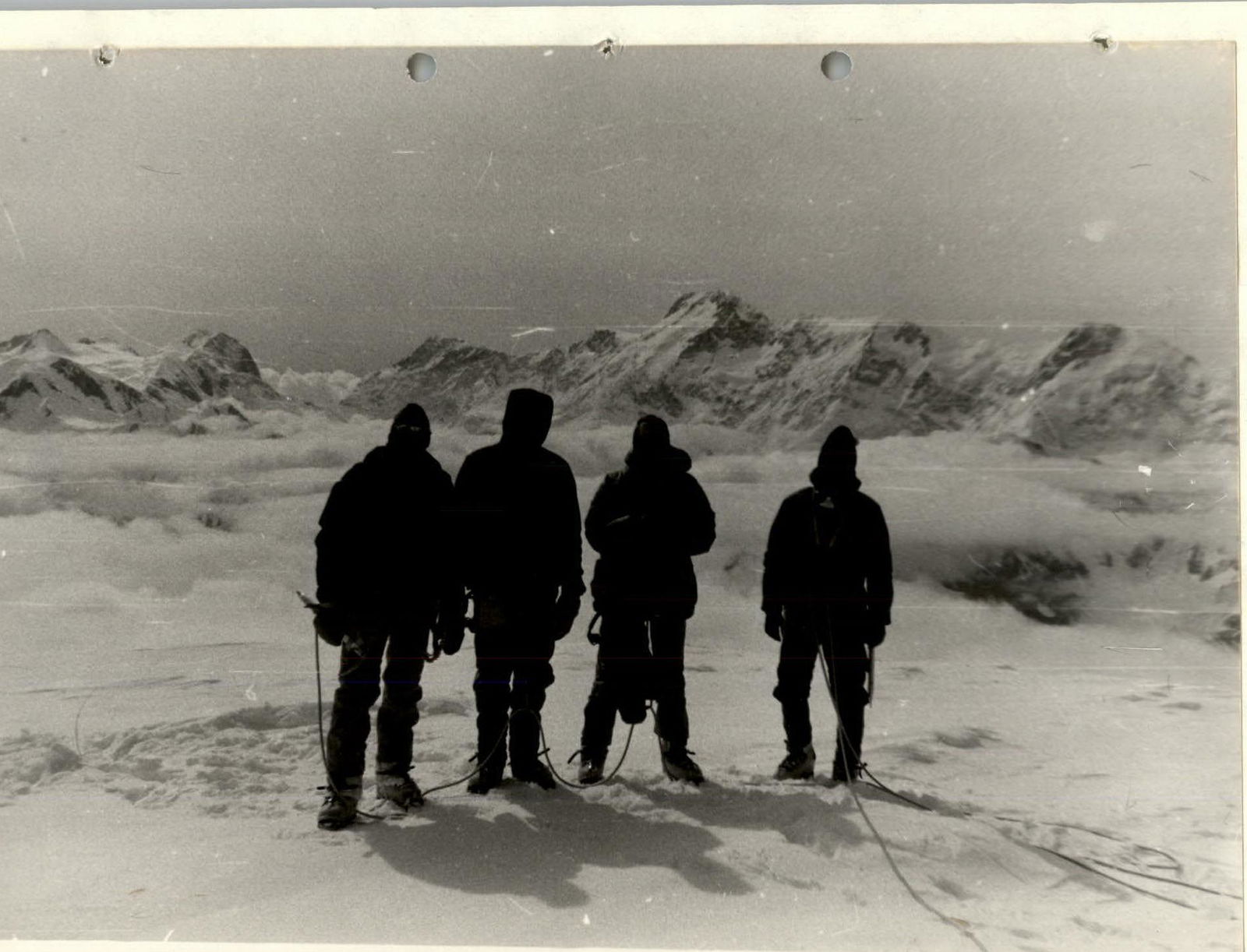
Photo 10. On the summit. In the background, Peak Pobeda. August 9, 1991, 8:45.

Photo 11. On the summit of Peak Petrovsky. To the left, Peak Khan-Tengri. August 9, 1991, 8:45.