1. Materials about the Semenov Peak area
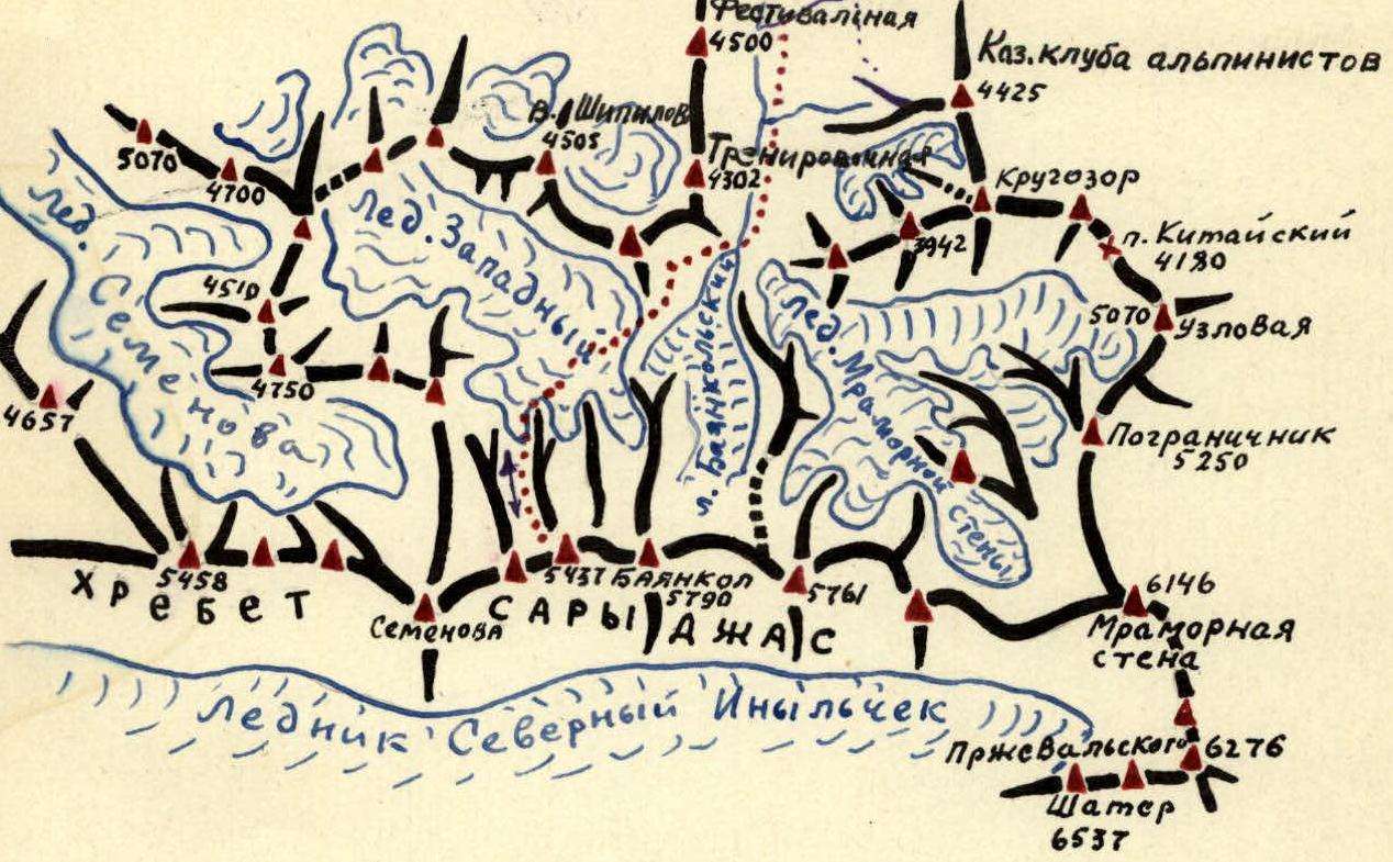
Semenov Peak (5816 m), one of the most famous peaks in the Central Tian Shan, is located in the eastern part of the Sarydzhas ridge in the upper reaches of the eponymous glacier. The huge glaciated mass of Semenov Peak is the highest point of this ridge.
East of Semenov Peak, in the Sarydzhas ridge, rises a two-headed peak (5437 m) - an important orographic node of Tian Shan. Here, the Terskey Alatau ridge (under the name of Katta-Ashutor) connects with Sarydzhas.
The orography of the Semenov Peak area is incorrectly shown on:
- the map of military topographers from 1943
- in the articles by A. Letavet and Timoshev "Conquest of the Marble Wall Peak"
- in the diagram by Nozdryukhin, etc.
The true structure of this area was first shown on the diagram by V. Kolokolnikov (1953).
And to the west (approximately 5 km away) is the unnamed peak "5488 m", which is also a photographic node (the Adyr-Tor ridge branches off from it, serving as a watershed between the Semenov and Mushketov glaciers).
In addition to the two main ridges mentioned, a powerful southeast spur branches off from the peak, from which in turn further branch off:
- the southern spur
- the southwest spur
All of them bear bright traces of glacial processing.
The powerful foundation of the peak consists of deposits of the schist stratum; in the summit area, light, sugar-like marbles are preserved.
Semenov Peak is the center of powerful glaciation. The masses of firn and ice sliding down the northern slopes of the peak feed the Semenov Glacier - the ninth largest glacier in Tian Shan.
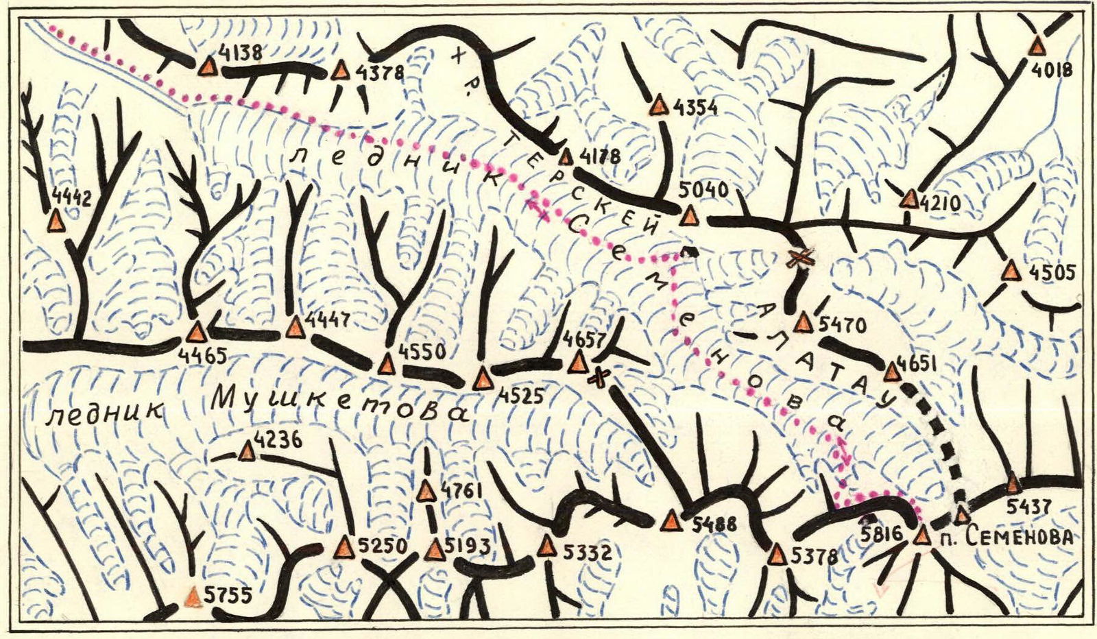
Diagram of the first ascent route to Semenov Peak (5816 m)
Conventional signs: ... Route Places of overnight stays
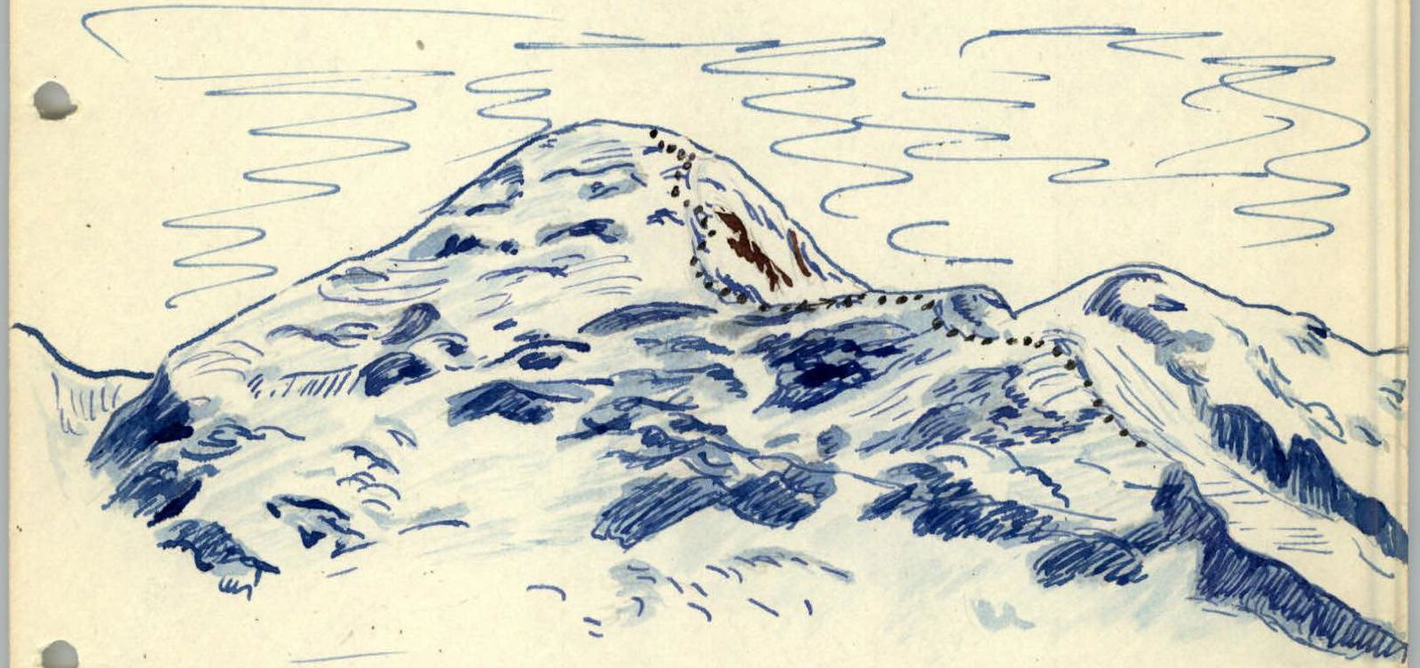
View of Semenov Peak from the northeast (from the upper reaches of the Zapadny Bayankol glacier). ... — Route of the group. Reaching 18.7 km in length with an area of 36.0 km².
The glaciation of the eastern slope feeds one of the large lateral tributaries of the Reznichenko glacier, and the firn masses of the western slope - a glacier similar to the one mentioned earlier. In two deep gorges on the southern slope lie small valley glaciers.
The first scientist to see the peak and discover a large glacier in the upper reaches of the Sarydzhas River was the great Russian traveler P.P. Semenov-Tyan-Shansky. 29 years later, in 1886, an expedition led by mining engineer Ignatiev investigated the tongue of the glacier discovered by P.P. Semenov, naming it after its discoverer.
In the summer of 1902, Professor V.V. Sapozhnikov's expedition visited the upper reaches of the Sarydzhas valley and gave the name "Semenov Peak" to the peak dominating the upper reaches of the Semenov Glacier.
For two years (1902-1903), an expedition led by German geographer and mountaineer G. Merzbacher worked in this and neighboring areas, aiming to ascend Khan Tengri and doing much to clarify the orography of this massif.
Merzbacher surveyed the Semenov Glacier and attempted to ascend Semenov Peak (engineer Poran, while attempting to ascend the "5488 m" peak, was caught in an avalanche at an altitude of 4300 m but survived by chance in a niche on the slope).
In 1931, a group from the OPRÉ led by V. Gusev penetrated the Reznichenko glacier (Severny Inylchek) and ascended the northern slope of Khan Tengri to a height of about 6000 m; they observed the southwestern slope of Semenov Peak.
In 1932, during the 2nd International Polar Year, Professor S.V. Kalesnik visited the upper reaches of Sarydzhas.
In the same year, a glaciological group from the Ukrainian scientific expedition - led by A. Zhavtrov (with the participation of V. Gusev) traversed and surveyed the entire Reznichenko glacier and visited the southern slopes of Semenov Peak.
In 1935, for the first time, one of the teams from the Tian Shan Alpine Expedition of the Red Army, led by Professor V.V. Nemyzky, crossed from the Bayankol glacier to the Semenov glacier via the eponymous pass (4400 m).
In 1946, Doctor of Geographical Sciences G.A. Avsyuk studied the Semenov Glacier.
The leader of the expedition of the Kazakh Club of Mountaineers and Tourists, V.M. Kolokolnikov, in 1953, ascended Peak 4761 m in the Terskey Alatau ridge, where it serves as a watershed between the Bayankol and Semenov glaciers, and established that the nodal peak is "5436 m", not Semenov Peak.
In 1954, a group led by V. Gusev visited the Bayankol area, repeating ascents of several non-difficult peaks.
In 1957, a group of mountaineers from the Kazakh Club worked in the area for an extended period. They ascended the Marble Wall and then Peak "5436 m", as well as several other peaks to scout the path to Semenov Peak.
Based on the gathered information, the most safe route was chosen, leading from the Semenov glacier along the western ridge.
Approaches
There are two convenient options for reaching the Semenov Peak area:
-
Along the Almaty - Narynkol highway to the village of Tekes, then along the Bayankol River valley and its source, Sary-Koynou, to the Zapadny Bayankol glacier, and then through the Semenov pass or the unnamed pass (located south of Peak 4761 m).
-
Along the Almaty - Frunze - Przhevalsk - Kok-Kiya highway, Chonamu pass - Ottuk - to the Kensu stream in the Sarydzhas valley, then to the Semenov glacier.
The 1958 expedition group, consisting of U. Usenov (group leader), V. Tsverkunov, B. Kuklichev, B. Krasilnikov, A. Semichenko, and V. Savukhin, followed this latter route. They reached the summit on September 10 at 12:00, with V. Savukhin and A. Semichenko achieving the ascent.
Description of the ascent from the base camp on the Semenov glacier
September 8. From the tongue of the Semenov glacier, the group moves up along the right (orographic) side of the glacier with pack horses. The path initially goes along the lateral moraine, crossing several water streams up to 10 m wide. The lateral moraine has steep, scree slopes. The horses are difficult to maneuver through these areas, requiring unloading and careful handling. The glacier's surface is heavily crevassed at first, so the group chooses a route bypassing this part of the glacier along the lateral moraine.
After about 3 hours, the group reaches a relatively flat and passable surface of the glacier and continues moving along the middle part. The glacier's slope gradually decreases to 2-5°. Upon reaching the middle part, on steeper sections, and when bypassing crevasses, there were instances of horses falling; it was necessary to cut steps.
Now, the group moves across a completely flat field covered with a thin layer of snow, under which deep, narrow water-filled pits are often encountered.
After 1.5 hours, the path is obstructed by crevasses, and the group turns left onto the lateral moraine, where they set up camp 5-6 hours after departing from the glacier's tongue. From here, the horses return downwards.
The elevation gain here above the camp at the glacier's tongue is 500 m. The altimeter shows 4030 m. The weather is clear and sunny.
September 9. Departure at 6:00. The path initially goes along the lateral moraine for about 30 minutes. Across the heavily crevassed glacier, the group gradually moves to the right and finds itself in the middle part of the Semenov glacier, which at this point is almost a horizontal vast field.
The snow layer is firm, making it easy to walk. There are almost no crevasses, or rather, they are all covered with strong, frozen "bridges". Gradually, the glacier turns to the right. The slope begins to increase but very gently. To the left remains a lateral glacier, 600 m wide, flowing into the Semenov glacier. This lateral glacier is short, flowing from the Terskey Alatau to the west.
Soon, the Semenov glacier sharply turns left to the east, encircling an unnamed height of around 5000 m in the Terskey Alatau ridge. The slope of the ascent increases to 20-25°. At 9:15, the group approaches the start of the ascent to the col between Semenov Peak and the unnamed peak in the Sarydzhas ridge to the west of the former. The altimeter shows 4460 m.
From here, a not very distinct ridge is visible, intersected by parallel, obliquely positioned rock outcrops. These rock sections are very noticeable, and even from a distance, this path appears to be the most convenient and safe.
Orientation here is reliable.
To the right and left of this path, the slopes are covered in ice, with many rockfalls and crevasses. The probability of avalanches and rockfalls is not very high. The weather starts to deteriorate.
State of the slopes:
- covered in ice
- many rockfalls
- crevasses
Hazards:
- high probability of avalanches
- rockfalls
The weather starts to deteriorate.
The ascent to the col took 6 hours. The approach to the start of the ridge is through deep, loose snow. The massive belt encompassing this


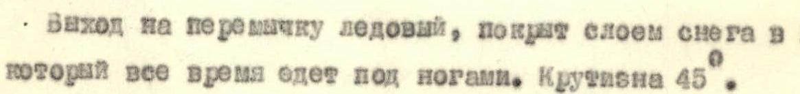

 ridge is approximately 1/6 of the height of the col. In this section, there are many deep crevasses up to 8-10 m wide, often covered with loose snow. The slope reaches 30-40°. Overcoming these crevasses requires great attention and caution. Then, the path goes directly along the ridge. The slope in some places reaches 50°. Rock inclusions are covered with ice, requiring ice axe work to clear. The exit to the col is icy, covered with a 20 cm layer of snow that constantly slips underfoot. The slope is 45°. On the col, an ice barrier with an overhanging cornice stands before us. We bypass it on the right and find ourselves before the very mass of Semenov Peak. Altitude 5205 m. Severe weather conditions. The wind makes it difficult to throw precipice (snow), or even talk. Visibility is poor. At 16:00, the group began digging a cave (snow shelter). The wind prevents snow removal. They create protective walls. Through the blizzard, a route for the assault on Semenov Peak via its western slope is discerned.
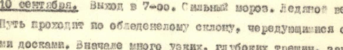
September 10. Departure at 7:00. Severe frost. Icy wind. The path goes along an icy slope, alternating with snow slabs. Initially, many narrow, deep crevasses are encountered, covered with a thin layer of snow. The ice is so firm that even the pick of the ice axe bounces off. The slope steepness quickly increases to 70° in places. The direction is kept towards a prominent ice "tooth" on the slope, 50-60 m high. The "tooth" is bypassed on the right. The ascent involves cutting steps. The sun only grazes the slope with its rays, making it even colder. The wind does not subside.
From the "tooth", the group ascends directly upwards, crosses a snow cornice and reaches under an ice wall 60 m high. They bypass it slightly to the right and, along a barely noticeable depression, overcome it "head-on". Soon, they reach the preliminary ridge. From here, 300 m of uncomplicated path leads to the summit, which is a wide, dome-shaped massif without rock outcrops. The panorama from here opens in all directions. Altitude 5910 m (these altimeter readings can only be used as relative elevation).
The group reached the summit at 12:00.
The descent followed the ascent route.
September 11. Return to the camp on the Semenov glacier.
September 12. Descent to the tongue of the glacier.
In the opinion of the group members, the ascent to Semenov Peak via the described route corresponds to category 4A difficulty.
Description compiled by:
(V. Tsverkunov)
(M. Grudzinsky)
Note: Section "Description of the ascent from the base camp on the Semenov glacier" was compiled by Comrade Tsverkunov, and the "chapter material" about the Semenov Peak area and approaches was compiled by Comrade Grudzinsky. April 4, 1959
Igor Zininov
Exit of the assault group from the base camp on the Semenov glacier.

On the summit of Semenov Peak (5816 m).
Diagram of the Bayankolsky cirque