
Ascent Passport
- Ascent class: high-altitude technical
- Ascent area: Central Tien Shan, Kuilyu-Tau ridge
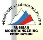
- Summit: Peak Sovetskoy Konstitutsii 5281 m, northwest wall.
- Proposed difficulty category 5B.
- Route characteristics: height difference 1181 m, section length 5–6 km, tp 945 m, average slope 70°.
- Pitons hammered:
- rock - 97
- ice - 60
- bolted - 0
- Number of travel hours - 70
- Number of overnight stays and their characteristics: 6 overnight stays, of which: 4 overnight stays (R1, R3, R4, R6) reclining; 2 overnight stays (R2, R5) semi-sitting.
- Surname, name, patronymic of the leader, participants and their qualifications. 9.1. Boshman Verner Frantsevich - Candidate Master of Sports, captain 9.2. Aizin Vladimir Borisovich - Master of Sports, participant 9.3. Kapanin Vladimir Aleksandrovich - Candidate Master of Sports, participant 9.4. Slepushkin Evgeny Filippovich - Master of Sports, participant
- Denisov Valery Georgievich - Master of Sports, team coach
- Date of departure on the route August 16, 1977
Date of return from the route August 22, 1977
- Route - first ascenders
- Ascent route (first ascent) of the combined team of Kir. SSR.
General view of Peak Sovetskoy Konstitutsii.
1977 is a significant year in the life of our country. This year marks the 60th anniversary of the Soviet state. No less important an event in the life of our state is the nationwide discussion of the draft Constitution of the USSR. These events played a significant role in our team's choice of the object of ascent (Peak Sovetskoy Konstitutsii) for the USSR championship.
Peak Sovetskoy Konstitutsii was first conquered in 1937 by a group of climbers from the Letavet expedition (Cherepov, Beloglazov, Ratsek, Popov) via the northern ridge - category 5A.
The next ascenders to the summit were climbers from Tashkent led by V. Elchibekov. In 1953, they deposited the text of the USSR Constitution.
In 1973, Chelyabinsk climbers ascended Peak Sovetskoy Konstitutsii via this route.
Our team, a team of climbers from the Committee for Physical Culture and Sports under the Council of Ministers of Kir. SSR, made an ascent of Peak Sovetskoy Konstitutsii via a new route - the northwest wall. In the final section, we left a draft of the new Constitution of the USSR in Russian and Kyrgyz, as well as flags of the USSR and the Kirghiz SSR.
Brief geographical description of the ascent area and approaches to the route. Peak Sovetskoy Konstitutsii is the highest point of the Kuilyu-Tau ridge, which is the watershed of the Kuilyu and Terekty rivers.
The ridge has a latitudinal orientation and represents the western continuation of the Saryjaz ridge, joining at an acute angle with the Terskey-Alatau ridge of east-northeast простирания. The Kuilyu-Tau ridge is composed of carbonaceous and carbonate-clay shales with limestones to a significant extent marmarized. These limestones, stronger and denser, are characterized in the relief by massive walls, edges, and counterforts, while weaker shale layers form depressions in the ridges: saddles, passes, and on the slopes - grooves, couloirs, etc. Very intense weathering, mainly frost weathering, causes significant destruction of the layers, so the route is replete with loose and "live" rocks, which poses an objective danger of rockfall on the wall.
The expedition of the Kyrgyz Sport Committee from Przhevalsk moved by car through the Chon-Ashu pass, the Inylchek settlement, to the confluence of the Terekty River into the Saryjaz River and further upstream along the Terekty River. 2 km from the mouth, the road was blocked, and further progress was made on foot. The path went upstream along the Terekty River for 15 km, then along the Ikichat River for 8 km to the glacial circus under Peak Sovetskoy Konstitutsii.
The base camp was located on the left-bank moraine under the tongue of the glacier descending from the northwest wall of the peak, at an altitude of 3800 m. The further path went under the tongue of the glacier and along the gentle right-bank moraine, bypassing the icefalls to the left. The assault camp was located on a lateral moraine 30 minutes' walk from the start of the route and 2 hours from the base camp.
— Path of the assault group — Approach

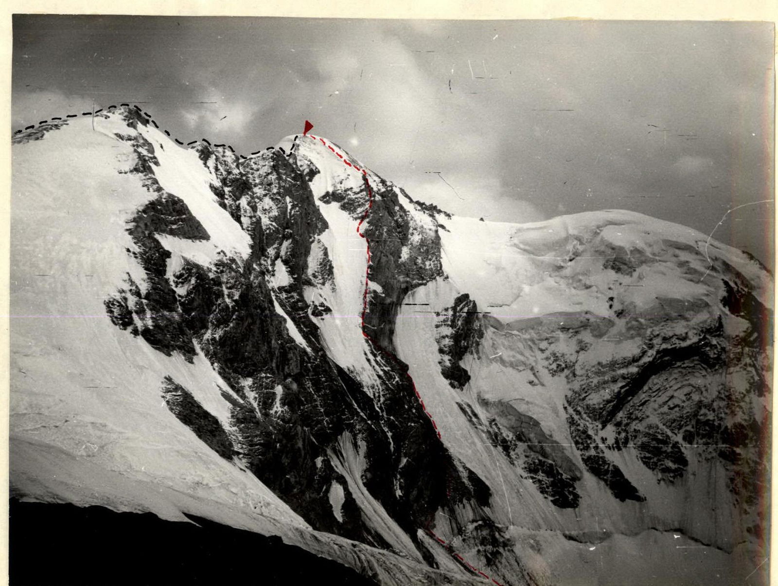
TABLE OF MAIN CHARACTERISTICS OF THE ASCENT ROUTE TO PEAK SOVETSKOY KONSTITUTSII 5281 m VIA THE NORTHWEST WALL. Height difference 1181 m, route length 1975 m, including most difficult sections 945 m, average slope of the wall section 70°.
PROFILE OF THE ROUTE. Marking of the start of the route 4100 m.

Explanation for the table
August 16. Departure for route processing from the assault camp according to the tactical plan (due to potentially hazardous rockfall sections R0-R4) at 4:30. The Kapanin-Slepushkin pair departs.
Along the ice slope, slope at the bottom 40°, in the upper part - 55°, length 190 m, they ascend to the bergschrund (section R0-R1). The bergschrund is overcome via an ice bridge. Further - ice slope, length 50 m, slope 55-65°, ice is accumulated (section R1-R2). Then along slopes with a slope of 80°, in the upper part up to 90°, up and to the right for 70 m (section R2-R3). Further - rocks with a slope of 70°, walls up to 5-10 m high, slope up to 90° (section R3-R4), which lead to a shelf with a slope of 45° under overhanging walls - the intended overnight bivouac site.
Using the fixed ropes, the pair descends to the bergschrund and below - to the assault camp. Movement is completed at 12:30.
August 17. At 6:00, we begin ascent via the "perils". Observers throw down excess ropes. At 11:00, the group reaches the previously designated shelf, where an overnight stay is organized. After lunch at 13:00, Kapanin and Slepushkin prepare the bivouac site (8 pitons hammered, semi-sitting overnight stay), and the Aizin-Boshman pair continues movement. First along the shelf to the right for 15 m, then a steep (90°) gully to the left and up for 15 m.
Further along "ram's brows" - 105 m, 75° (section R4-R5) under a 40-meter wall with a slope of 80-85°, ending in a small shelf for one person (section R5-R6). From here, a 3 m wall upwards, then to the right and up along a shelf for 4 m into a couloir 70 m long (section R6-R7), slope 85-90°. In the lower part, the first 7 m of the couloir and in the middle part 5 m, the slope reaches 100°. The couloir leads under an overhanging wall, under which there is a wide, convenient shelf for an overnight stay. At 20:00, the pair descends to the bivouac via the fixed ropes.
August 18. Start of movement at 7:00 via the previously fixed ropes. At 11:30, the group is on the shelf, where an overnight stay is organized. After lunch at 13:00, Aizin-Kapanin begins processing the wall (traverse to the left: first along the shelf, then along the wall). Aizin is in the lead. Progress is very slow, rocks are heavily destroyed, ladders are used for passage, and ice pitons are often hammered. In five and a half hours, only 30 m are covered. At 18:30, Aizin returns to the bivouac - bad weather sets in: snowfall, thunderstorm, further progress is impossible. Overnight stay is reclining.
August 19. Departure due to bad weather only at 12:00. The Kapanin-Boshman rope works. At 15:30, Kapanin reaches the shelf, having traversed the remaining ten meters of the complex section, and then along "ram's brows" to the left and up under the wall for 80 m. Very complex climbing. The pair returns to the bivouac at 20:00.
August 20. Departure at 7:00. The Boshman-Aizin rope is in the lead. In 5 hours, they cover the processed section (R7-R9) - 120 m. Then upwards along the counterfort (section R9-R10): movement is mainly along rocks, interspersed with short ice combes, slope up to 65-70°. At 19:00, they reach the "sickle" - the only place on the counterfort for an overnight stay. They chop an ice ridge - a semi-sitting overnight stay, quite satisfactory.
August 21. Departure at 7:00. The Aizin-Boshman rope is in the lead. Movement along the ice slope, slope 60-70°, in the upper part - step cutting (section R10-R11). Then an internal corner, upwards to the right for 20 m, covered in ice (section R11-R12), slope 75-80°. After the internal corner - a wall 20 m (section R12-R13): first 10 m upwards, slope 90-95°, then upwards to the left for 10 m - the wall passes into a steep, icy couloir, length 50 m, slope 80° (section R13-R14), leading under the wall of the pre-summit gendarme (section R14-R15). The wall is monolithic, few cracks, climbing is very complex, 4 ladders are hung. The wall's length is 35 m, slope 90°. The wall ends on a shelf with a slope of 45°, width 0.5 m, after which - a wall 25 m (section R15-R16), slope 80-85°, leading to the pre-summit ice ridge (section R16-R17) with a length of 220 m, slope up to 55° with a flattening towards the summit. In the lower and middle parts of the ridge - ice, and in the upper part - firn. At 18:00, the group reaches the summit.
The summit is a cornice facing southeast. A cairn is on rocks along the descent route via the northern ridge, on the route of category 5A, 70 m below the summit. We descend to the saddle between the summit and the gendarme and at 20:00 stop for a comfortable overnight stay. August 22. Departure at 7:00. Along the northern ridge (route of category 5A), we descend to the pass, and then along scree couloirs - to the moraine. The group descends to the base camp at 16:00.
Section R11-R12
Comments
Sign in to leave a comment