Ascent Certificate
- Ascent class — combined
- Ascent region — Tian-Shan, Kungey Alatau ridge
- Peak — Parus, height 4130 m via the East ridge from Parus glacier, comb
- Estimated difficulty category — 2B
- Route characteristics:
- height difference — 590 m
- average steepness — 25°
- sections of 5th category — none
- Pitons hammered:
- for belaying — 4, for creating belay anchors — none
- Overnights on the route — none
- Number of climbing hours — 9 hours
- Group composition:
- Ganyalin V.A. — Candidate Master of Sports
- Maydanyuk V.I. — 1st sports category
- Team coach — Ganyalin V.A.
- Date of departure on the route — August 15, 1981
TABLE OF MAIN CHARACTERISTICS OF THE ASCENT ROUTE
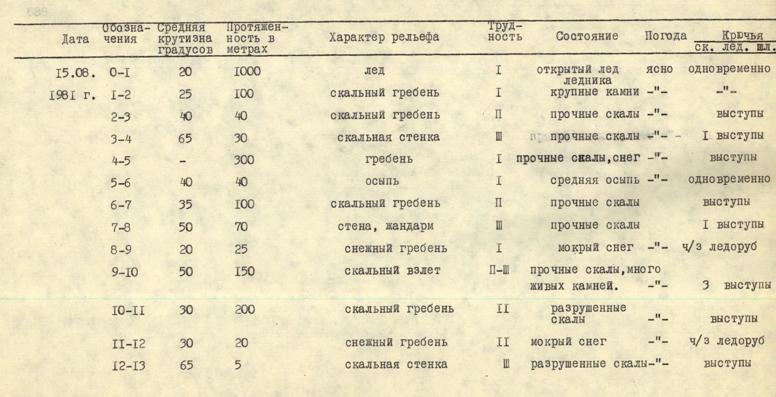
| Date | Designation | Average steepness in degrees | Length in meters | Terrain character | Difficulty | Condition | Weather | Pitons rock ice belay anchors |
|---|---|---|---|---|---|---|---|---|
| August 15, 1981 | R0–R1 | 20 | 1000 | glacier | 1 | open glacier ice | clear | simultaneously |
| R1–R2 | 25 | 100 | rocky ridge | 1 | large stones | -"- | -"- | |
| R2–R3 | 40 | 40 | rocky ridge | 2 | solid rocks | -"- | ledges | |
| R3–R4 | 65 | 30 | rocky wall | 3 | solid rocks | -"- | 1 ledges | |
| R4–R5 | - | 300 | ridge | 1 | solid rocks, snow | -"- | ledges | |
| R5–R6 | 40 | 40 | scree | 1 | medium scree | -"- | simultaneously | |
| R6–R7 | 35 | 100 | rocky ridge | 2 | solid rocks | ledges | ||
| R7–R8 | 50 | 70 | wall, gendarme | 3 | solid rocks | 1 ledges | ||
| R8–R9 | 20 | 25 | snowy ridge | 1 | wet snow | -"- | via ice axe | |
| R9–R10 | 50 | 150 | rocky ascent | 2–3 | solid rocks, many loose stones | 3 ledges | ||
| R10–R11 | 30 | 200 | rocky ridge | 2 | broken rocks | ledges | ||
| R11–R12 | 30 | 20 | snowy ridge | 2 | wet snow | -"- | via ice axe | |
| R12–R13 | 65 | 5 | rocky wall | 3 | broken rocks | -"- | ledges |