Ascent Record
- Ascent class — combined
- Ascent area — Tian Shan, Kungey Alatau range
- Peak — MALENKIY PRINZ, height — 3860 m, route — from the West along the Northern ridge, combined.
- Estimated difficulty category — 2A
- Route characteristics:
- height difference — 550 m
- average steepness — 30°
- sections of 5th difficulty category — none
- Pitons hammered:
- for belay — 3, for creating belay anchors — none
- rock — 2, ice — 1
- Overnights on the route — none
- Number of climbing hours — 7 hours
- Group composition: Ganyalin V.A. — Candidate for Master of Sports, ascent leader Koreva A.M. — 2nd sports category, participant Khomogorov A.I. — 3rd sports category, participant Prokhorov A. — 3rd sports category, participant
- Team coach — Ganyalin V.A.
- Date of departure on the route and ascent — July 15, 1981
TABLE OF MAIN CHARACTERISTICS OF THE ASCENT ROUTE
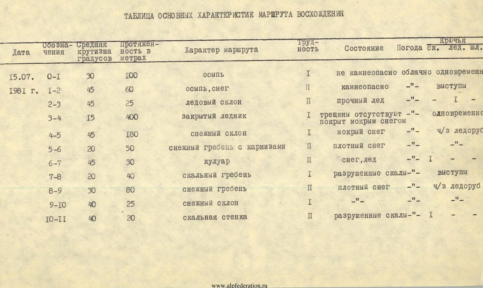
| Date | Designations | Average steepness, degrees | Length in meters | Route character | Difficulty | Condition | Weather | Rock pitons | Ice pitons | Hang. pitons |
|---|---|---|---|---|---|---|---|---|---|---|
| 15.07. | O–I | 30 | 100 m | talus | I | not rockfall-prone | cloudy | simultaneous | ||
| 1981 | 1–2 | 45 | 60 m | talus, snow | II | rockfall-prone | «–» | ledges | ||
| 2–3 | 45 | 25 m | ice slope | II | solid ice | «–» | I | |||
| 3–4 | 15 | 400 m | closed glacier | I | crevasses absent, covered with wet snow | «–» | simultaneous | |||
| 4–5 | 45 | 180 m | snow slope | I | wet snow | «–» | through ice axe | |||
| 5–6 | 20 | 50 m | snow ridge with cornices | II | dense snow | «–» | «–» | |||
| 6–7 | 45 | 30 m | couloir | II | snow, ice | «–» | I | |||
| 7–8 | 20 | 40 m | rocky ridge | I | destroyed rocks | «–» | ledges | |||
| 8–9 | 30 | 80 m | snow ridge | II | dense snow | «–» | through ice axe | |||
| 9–10 | 40 | 25 m | snow slope | I | «–» | «–» | ||||
| 10–II | 40 | 20 m | rocky wall | II | destroyed rocks | «–» | I | «–» | «–» |