Ascent Passport
- Ascent class — combined.
- Ascent area — Tian Shan, Kungey Alatau.
- Peak — KRISTALL, height 3830 m, route along the Southeast ridge from the saddle, combined rock.
- Estimated difficulty category — 3B.
- Route characteristics:
- height difference — 460 m;
- average steepness — 30°;
- sections of 5th difficulty category — none.
- Pitons hammered:
- for belay — 20, for creating belay stations — none;
- rock — 20, ice — none, bolt — none.
- Overnights on the route — none.
- Number of climbing hours — 9.
- Group composition:
| — Ganyalin V.A. | CMS | leader |
| — Budyko D.I. | 1st sports category | participant |
| — Zabara Yu.M. | 1st sports category | —"— |
| — Litvinov A.V. | 1st sports category | —"— |
- Team coach — Ganyalin V.A.
- Date of departure on the route and ascent — July 23, 1981.
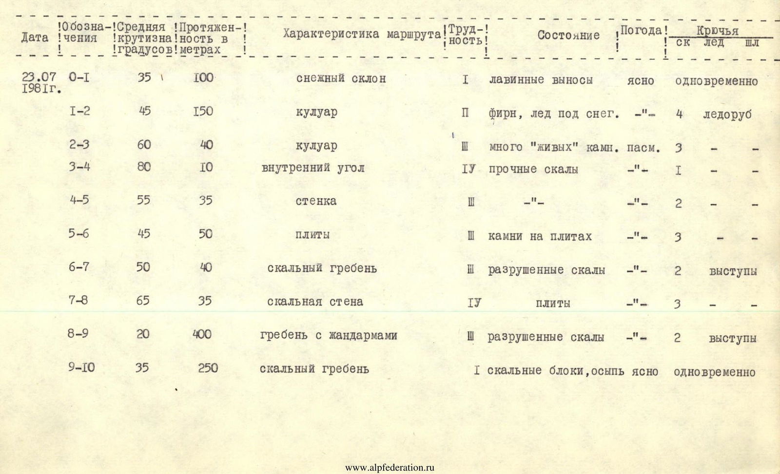
Table of main route and ascent characteristics
| Date | Designation | Average steepness | Length | Route characteristics | Difficulty | Condition | Weather | Rock pitons | Ice pitons | Bolt pitons |
|---|---|---|---|---|---|---|---|---|---|---|
| July 23, 1981 | R0–R1 | 35° | 100 m | snow slope | 1 | avalanche deposits | clear | simultaneous | — | — |
| — | R1–R2 | 45° | 150 m | couloir | 2 | firn, ice under snow | —"— | 4 | ice axe | — |
| — | R2–R3 | 60° | 40 m | couloir | 3 | many "live" stones | cloudy | 3 | — | — |
| — | R3–R4 | 80° | 10 m | inner corner | 4 | solid rocks | —"— | 1 | — | — |
| — | R4–R5 | 55° | 35 m | wall | 3 | —"— | —"— | 2 | — | — |
| — | R5–R6 | 45° | 50 m | slabs | 3 | stones on slabs | —"— | 3 | — | — |
| — | R6–R7 | 50° | 40 m | rock ridge | 3 | destroyed rocks | —"— | 2 | ledges | — |
| — | R7–R8 | 65° | 35 m | rock wall | 4 | slabs | —"— | 3 | — | — |
| — | R8–R9 | 20° | 400 m | ridge with gendarmes | 3 | destroyed rocks | —"— | 2 | ledges | — |
| — | R9–R10 | 35° | 250 m | rock ridge | 1 | rock blocks, scree | clear | simultaneous | — | — |