
Russian Mountaineering Championship
High-Altitude Technical Class
2023
Report
On the First Ascent
to the summit of Peak Uluun (5588 m) via the S wall and W ridge, category 6A (proposed) complexity by the team from St. Petersburg from August 23, 2023, to August 30, 2023.
Ascent Passport
| 1. General Information | ||
|---|---|---|
| 1.1 | Name, sports rank of the leader | Andrey P. Panov, Master of Sports |
| 1.2 | Name, sports rank of the participants | Oksana A. Kochubey, Candidate for Master of Sports; Sergey M. Seryanov, Candidate for Master of Sports; Ilya M. Zhdanov, 1st sports rank |
| 1.3 | Name of the coach | Tatyana I. Timoshenko; Vladimir A. Molodozhen |
| 1.4 | Organization | St. Petersburg Regional Public Organization "Federation of Alpinism" |
| 2. Characteristics of the Ascent Object | ||
| 2.1 | Region | 7. TIAN-SHAN 7.5. Kokshaal-Too ridge |
| 2.2 | Valley | Kechiksai glacier |
| 2.3 | Number of the section according to the electronic Russian classifier of routes to mountain peaks | 7.5 |
| 2.4 | Name and height of the peak | Peak Uluun (5588 m) |
| 2.5 | Geographical coordinates of the peak (latitude/longitude), GPS coordinates | N 41.01839° E 77.31484° |
| 3. Characteristics of the Route | ||
| 3.1 | Name of the route | via the S wall and W ridge |
| 3.2 | Proposed category of complexity | 6A |
| 3.3 | Degree of route exploration | First Ascent |
| 3.4 | Nature of the route relief | rock-ice |
| 3.5 | Height difference of the route (altimeter or GPS data) | 795 m (4793 m - 5588 m) |
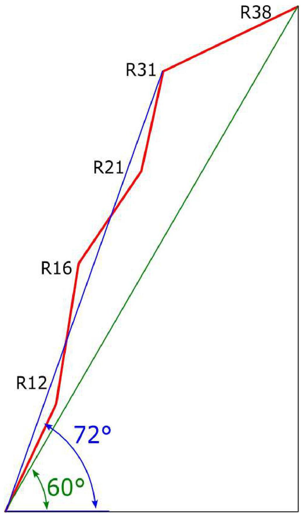
| 3.6 | Length of the route (in meters) | Total - 1240 m, wall part - 1050 m, ridge - 190 m |
| 3.7 | Technical elements of the route (total length of sections of various complexity categories with indication of relief nature (ice-snow, rock)) | II–III cat. compl. — 250 m, IV cat. compl. — 400 m, V cat. compl. — 400 m, VI cat. compl. — 190 m (including A2/A2+ — 120 m) |
| 3.8 | Average steepness of the route, ° | 60 |
| 3.9 | Average steepness of the main part of the route, ° | 72 |
| 3.10 | Descent from the summit | From the summit, rappelling down the ice slope to the SW, to the flattening of the S edge. Then rappelling to the E, first down the ice slope, then down the sheer rocks. Total ~20 rappels. |
| 3.11 | Additional characteristics of the route | |
| 4.1 | Time of movement (team's walking hours, in hours and days) | 36 h, 6 days, including 2 days of "sitting out" |
| 4.2 | Night camps | Lying in tents. Places for night camps were equipped by the team on steep snowy slopes. |
| 4.3 | Time of route processing | – |
| 4.4 | Exit to the route | 10:00 August 23, 2023 |
| 4.5 | Exit to the summit | 12:00 August 28, 2023 |
| 4.6 | Return to the base camp | 2:00 August 30, 2023 |
| 5. Characteristics of Weather Conditions | ||
| 5.1 | Temperature, °C | –15 °C – +5 °C |
| 5.2 | Wind speed, m/s | Gusts up to 15 m/s |
| 5.3 | Precipitation | During the ascent, heavy snowfalls occurred. More than a meter of snow fell in the area (Tents left in the base camp were buried "with a top") |
| 5.4 | Visibility, m | 10 m – 10 000 m |
| 6. Responsible for the Report | ||
| 6.1 | Name, e-mail | Andrey O. Panov aopanov@gmail.com |
General photo of the route
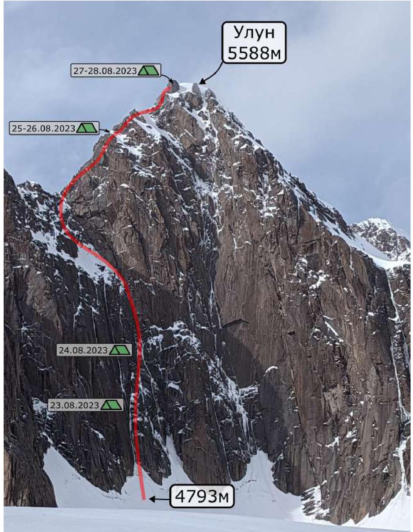
6A Panov 2023
photo taken: August 22, 2023 coordinates: N 41.00050° E 77.31229°
Profile of the route
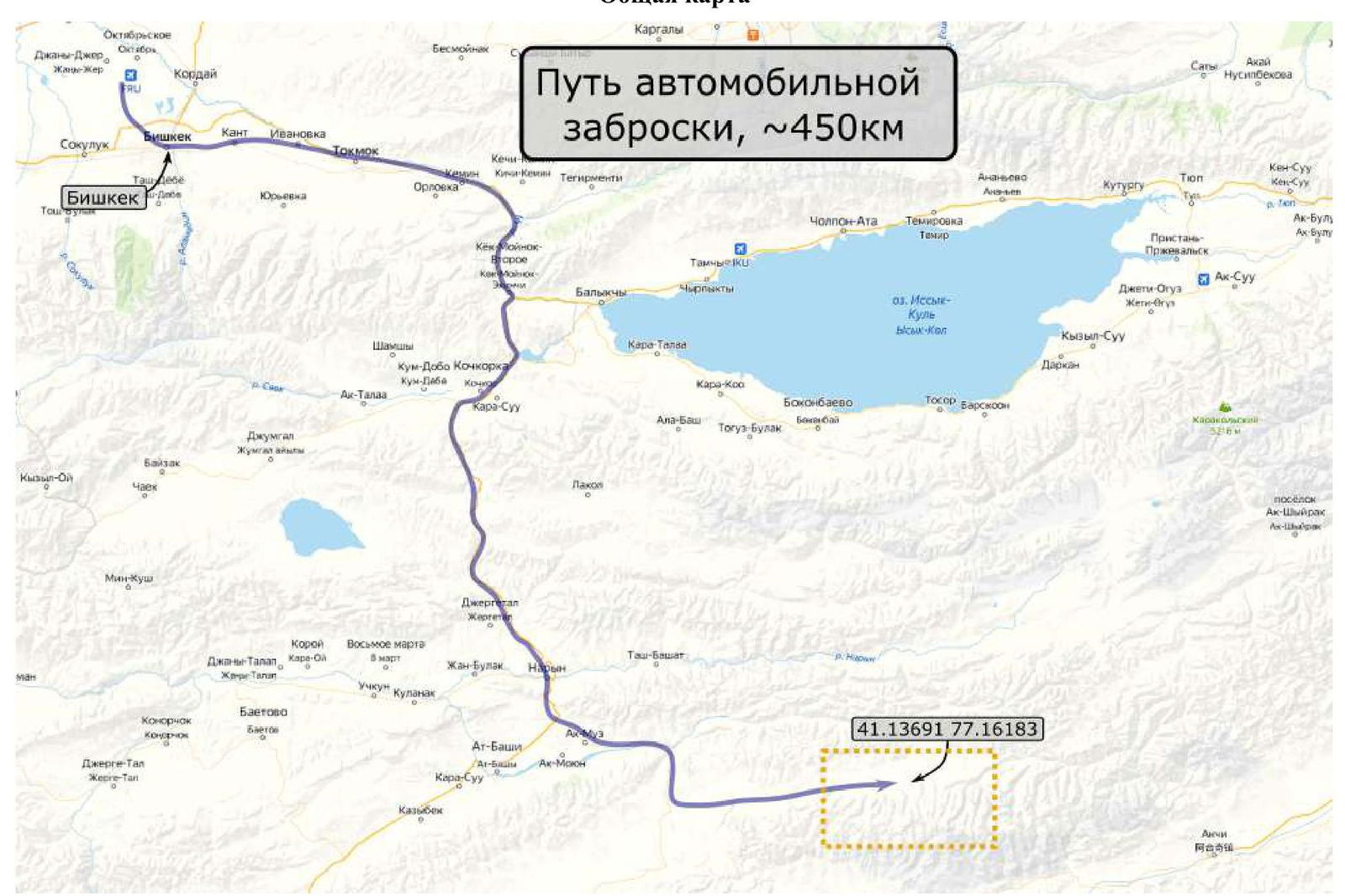
 General map
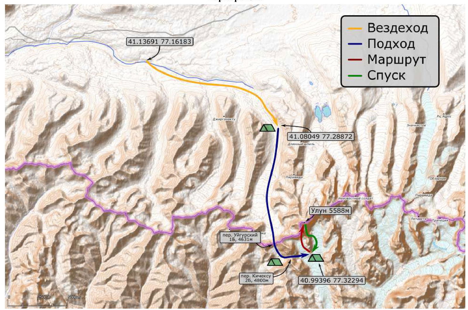
 Map of the area
Description of the Area
KOKSHAL-TAU (Koksal-Tau) is one of the highest mountain ranges in Tian-Shan, on the border between Kyrgyzstan and China. It borders the Inner Tian-Shan from the south, stretching 400 km in a southwest direction.
The area is relatively unexplored by mountaineers, although it is promising, with many peaks around 6000 m. Some of the most interesting peaks include: Kyzyl-Asker (5842 m), Peak Krylya Sovetov (5800 m), Peak Shmidt (5954 m), Peak Dankova (5982 m), Peak Chon-Turasy or Joldash (5729 m), Peak Alpinist (5641 m), Peak Sergey Korolev (5816 m), Peak White (5697 m).
The area is dominated by high-altitude relief with sharp ridges and sharp peaks carrying glaciers. It is characterized by a combination of typically alpine forms (many vertical rock walls with a height difference of up to 1.5 km) with vast glaciation, уступающим only the glaciation in the area of Peak Pobeda in Tian-Shan. The entire area, including lowlands, is a zone of permafrost. Often there are swampy areas up to altitudes of 4000 m.
The snow line is at an altitude of about 4000–4500 m above sea level. The valleys of the rivers have a high absolute height of about 3000–3500 m above sea level. The climate in the valley is harsh. The average monthly temperature in summer is about 5–8 °C, and the weather is unstable.
At the time of the team's arrival, Peak Uluun was unclimbed. The only known attempt to climb the peak was made by a team led by E.G. Murin in 2021. (Then their team passed several ropes through the center of the wall and was forced to descend.)
The road to the base camp can be divided into three stages:
- Off-road drive of about 450 km from Bishkek to the hunters' base.
- Off-road drive to the Dzhinar-Ak-Tash valley.
- Hiking approximately 15 km.
The hiking part of the approach took 5 days (due to the large amount of equipment and food, as well as bad weather, it was necessary to make multiple trips). The route of the hiking approach starts from the Dzhinar-Ak-Tash glacier and then through the passes: Uigur (1B, 4631 m) and Kechik-su (2B, 4800 m) respectively. The weather was unstable, with snow and thunderstorms in the afternoon. The total weight of the equipment for the entire group was about 200 kg.
Technical photos of the route:
- Lower part:
- Middle part:
- Upper part:
Approach (from the base camp under the wall of Peak Uluun):
From the base camp (N 40.99396° E 77.32294°), move northwest along the Kechik-su glacier, leaving the rocky massif to the right and the glacier tongue to the left. The peak is a dominant feature in the cirque and has a pronounced peak. Move in its direction for 1.5 km.
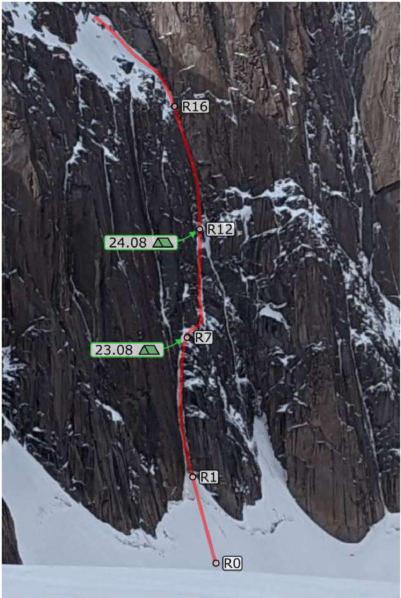
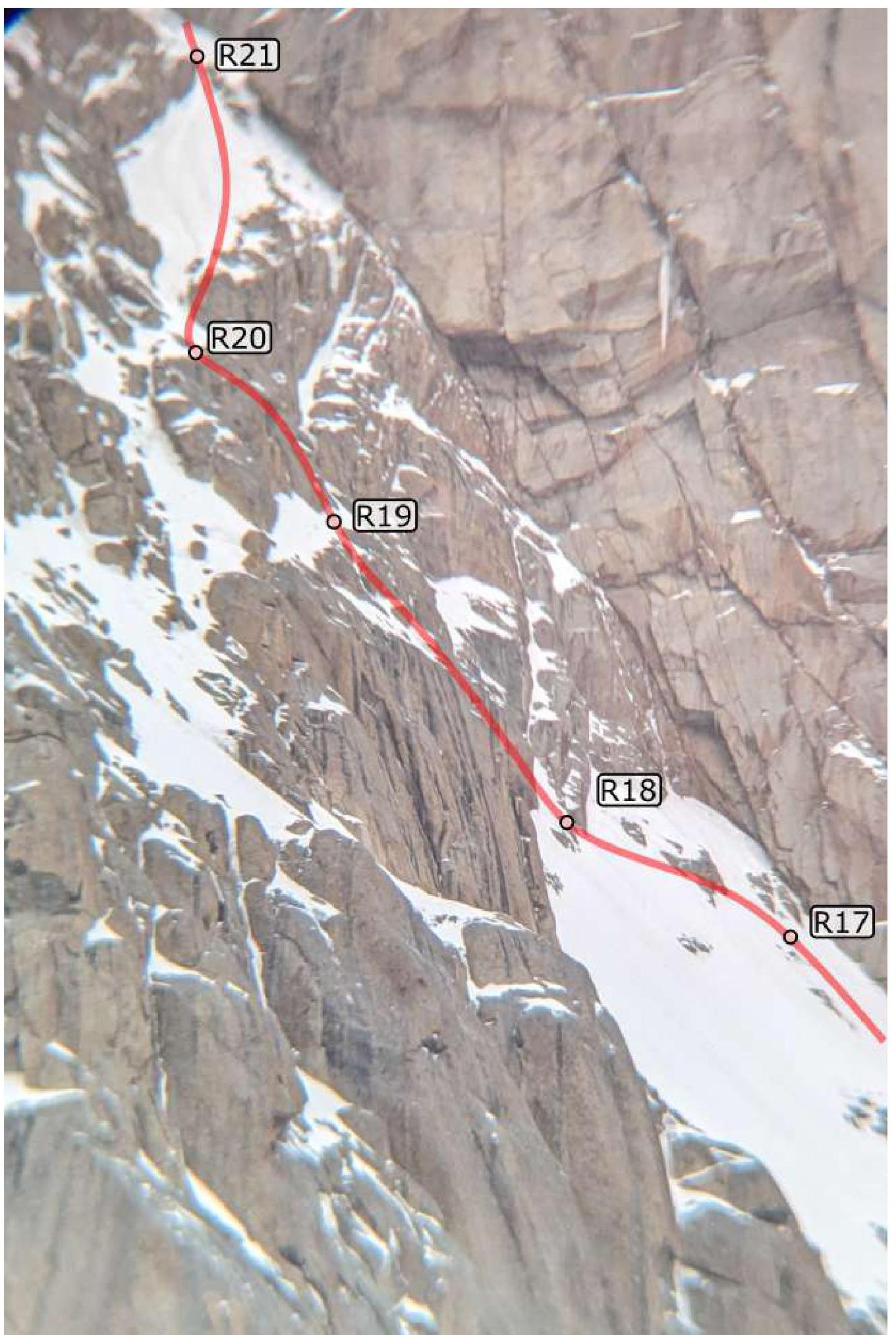
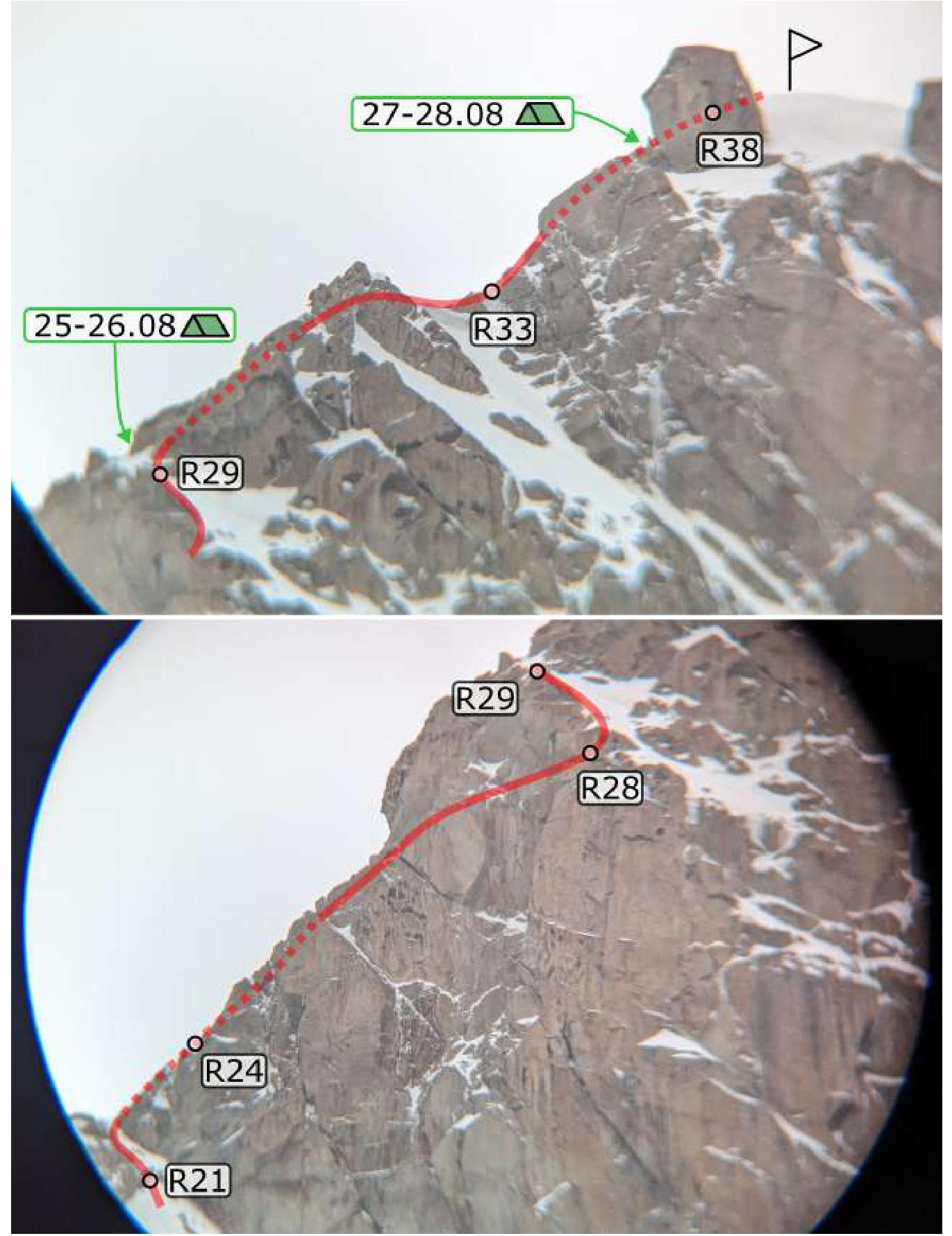
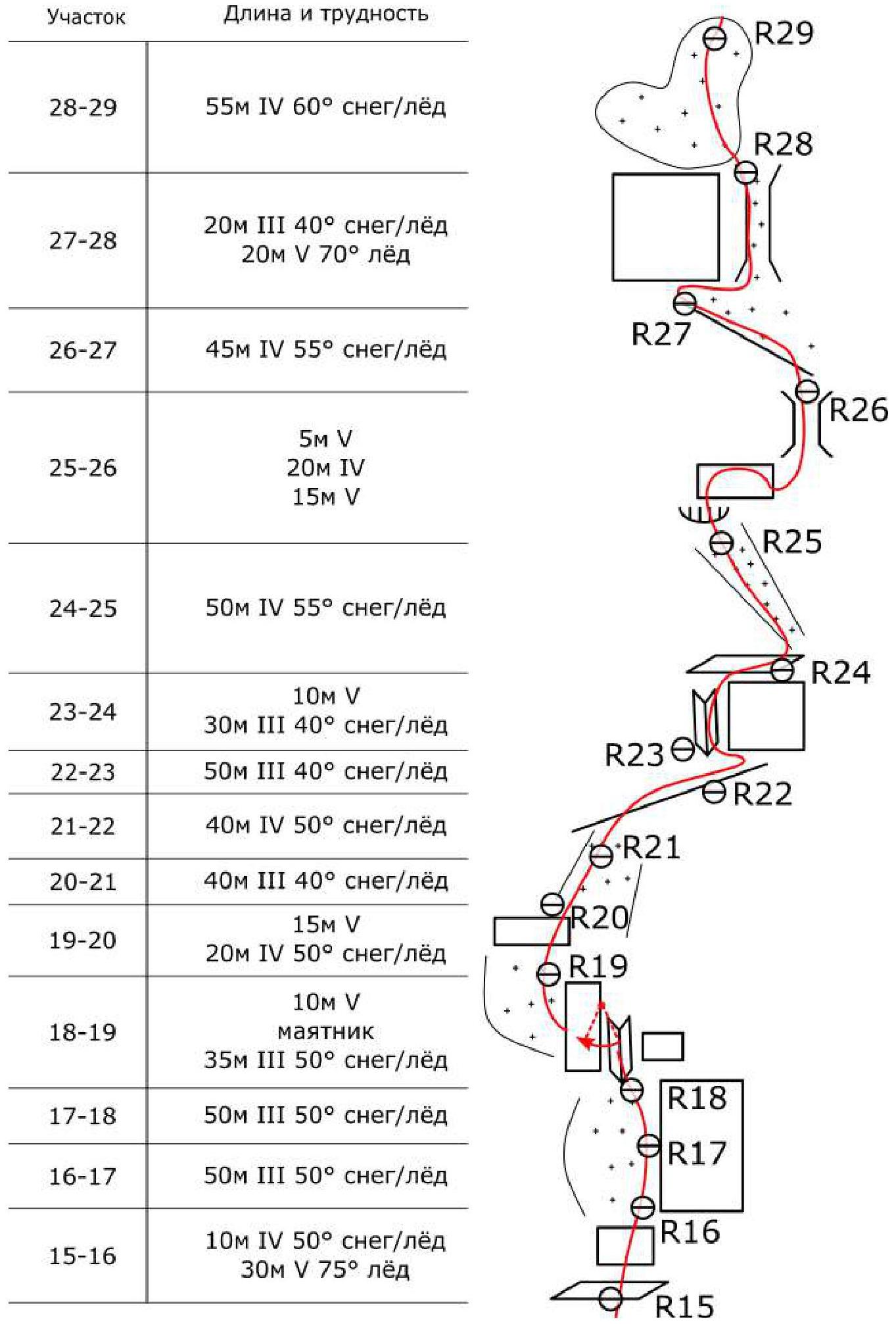
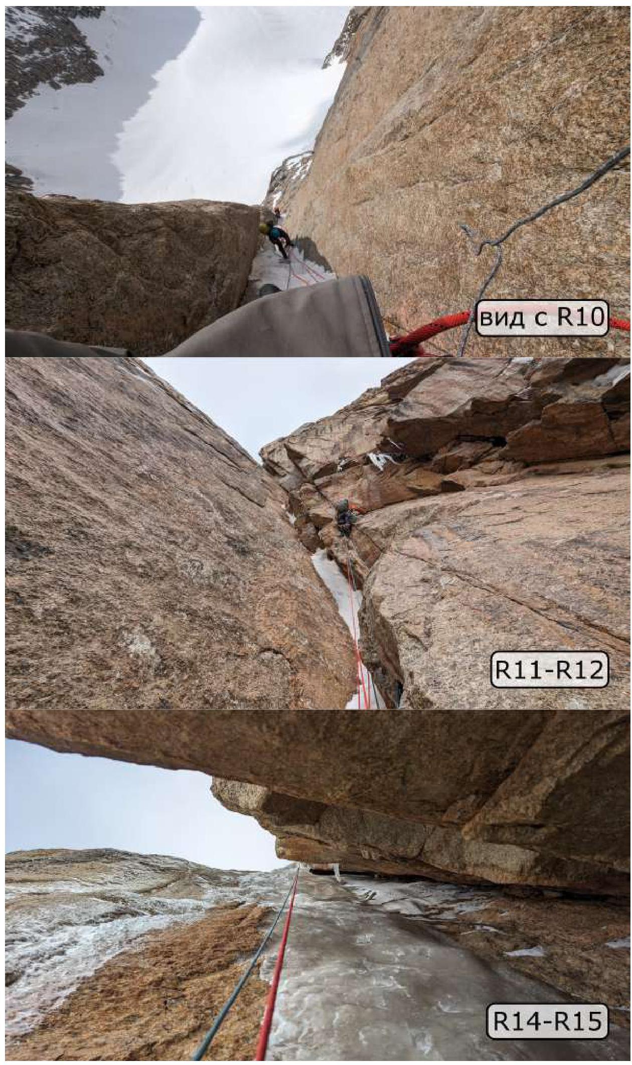
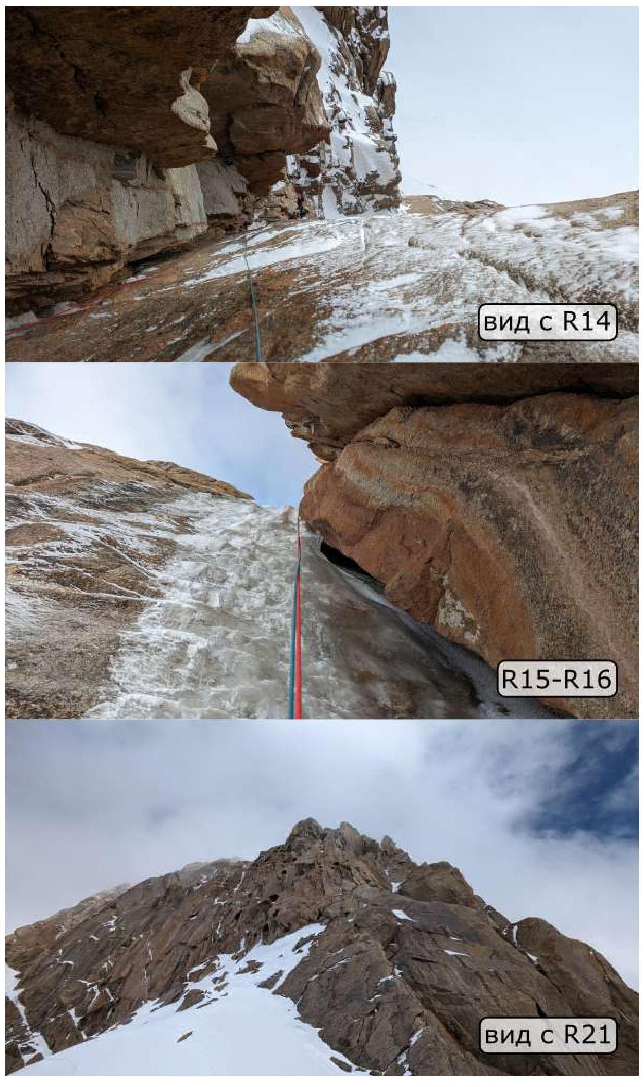
R0–R1 (150 m: 2 30°–40° firn) Move up the snow-ice outrun. Overcome the bergschrund from the right side and approach the rock wall. R1–R7 (235 m: 50 m 5, 30 m A2, 100 m 5 70° ice, 55 m 4 50° snow/ice) Move up a series of corners-cracks. Thin glacial ice on the "lamb brows", sometimes it is necessary to switch to IT - the ice melts under the sun and does not hold. At the end, the path is blocked by a small wall. R7–R8 (40 m: 5 m A2, pendulum, 15 m 6 80° ice, 20 m 5) Climb 5 m on IT, pendulum to the right to the corner (anchor left), on a thin internal corner filled with ice, traverse to the right along smooth slabs to the neighboring internal corner. R8–R9 (40 m: 10 m A2, 15 m 6 80° ice, 15 m 4 50° snow/ice) On the right side of the corner on IT, climb under the frozen waterfall, up, exit to the flattening. R9–R12 (120 m: 30 m 5, 30 m A2, 60 m 4 50° snow/ice) Move up a series of internal corners, sometimes the corners are interrupted by walls - IT, climbing. The ice is thin and fragile, melts under the sun. R12–R13 (40 m: 10 m 5 70° ice, 20 m 5, 10 m A2) From here begins a huge destroyed chimney. The rock is fragile. First, climbing, then on IT, move up the right part, through small overhangs. R13–R14 (40 m: 10 m 5, 20 m A2, 10 m 5) Move to the left part, cautious climbing through cornices, move up. R14–R15 (50 m: 7 m A2+, 43 m 6 90° ice) Carefully on IT, move to the left wall of the chimney. The wall is filled with glacial ice. The ice is very thin, even short ice screws are screwed in only halfway. Move very carefully up. At the top, the ice crust becomes thicker, insurance appears. Make a station on the flattening. R15–R16 (40 m: 10 m 4 50° snow/ice, 30 m 5 75° ice) After the flattening, climb another steep ice wall, exit from the chimney to the snow field. R16–R17 (50 m 3 50° snow/ice) Move up along the border of rocks and ice. R17–R18 (50 m 3 50° snow/ice) Continue moving up, turning left, approach the rock belt. R18–R19 (45 m: 10 m 5, pendulum, 35 m 3 50° snow/ice) Climbing, climb a small internal corner, at the top, make a pendulum and move to the left wall, to the next field. Along it, approach the next wall. R19–R20 (35 m: 15 m 5, 20 m 4 50° snow/ice) Up the wall, and then up. R20–R21 (40 m 3 40° snow/ice) Traverse to the right, into the snow-ice couloir. R21–R22 (40 m 4 50° snow/ice) Exit to the ridge, approach the rock belt. R22–R23 (50 m 3 40° snow/ice) Traverse to the left. R23–R24 (40 m: 10 m 5, 30 m 3 40° snow/ice) Climb a small internal corner, and then to the right. R24–R25 (50 m 4 55° snow/ice) Move up the couloir-chimney, to a small rocky cornice. R25–R26 (40 m: 5 m 5, 20 m 4, 15 m 5) Carefully climb the cornice on the right side, then along the rocky wall, traverse to the right, descend a bit. Through a small chimney, climb to the snow-ice field. R26–R27 (45 m 4 55° snow/ice) Up the field, the path is blocked by a large smooth wall. R27–R28 (40 m: 20 m 3 40° snow/ice, 20 m 5 70° ice) On the right side, at the base of the wall, a narrow chimney-couloir with ice begins. Along it, exit to the top of the rocky wall. R28–R29 (55 m 4 60° snow/ice) Then along the snow-ice fields. R29–R30 (45 m: 4 30 m 55° snow/ice, 15 m 5) Exit to the snow shoulder, through a small wall, climb to the large stone blocks. R30–R31 (20 m 5) Bypass the blocks from the right, through a small passage and then along the wall, climb up, return to the left. R31–R32 (40 m 4 60° snow/ice) Up the snow-ice field. R32–R33 (40 m 3 40° snow/ice) Traverse to the right, and then along the snow "knife" approach the rocky ridge. R33–R34 (40 m 5) Along the rocky ridge, climbing up. R34–R36 (100 m 3–5 40°–75° snow/ice) Up the snow-ice fields. R36–R37 (50 m: 10 m 5, 30 m 5 70° ice, 10 m 3 40° snow) Overcome a small internal corner-chimney, then bypassing the rocky "islands" to the right, move up. Exit to the summit ridge. R37–R38 (40 m 3 40° snow/ice) Along the snow "knife" for 20 m, descend into a hollow. Here is a control tour with a note. From the hollow, 10 m up the snow to the summit.
Descent:
Descent by rappelling, directly from the summit to the SE. First, along the ice slope on ice screws, then along the "lamb brows" (about 10 rappels). Descend to the flattening of the S ridge of Peak Uluun. Then to the E, first along the ice slopes and rocky "islands", then 300 m along sheer rocky "mirrors".
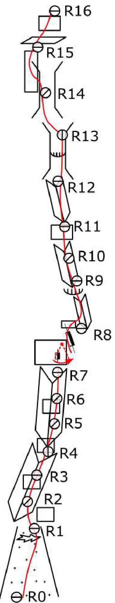
Scheme of the route in UIAA symbols lower part:
| Section | Length and Difficulty |
|---|---|
| R14–R15 | 7 m A2+, 43 m 6 90° ice |
| R13–R14 | 10 m 5, 20 m A2, 10 m 5 |
| R12–R13 | 10 m 5 70° ice, 20 m 5, 10 m A2 |
| R11–R12 | 30 m 5, 30 m A2 |
| R10–R11 | 60 m 4 50° snow/ice |
| R9–R10 | |
| R8–R9 | 10 m A2, 15 m 6 80° ice, 15 m 4 50° snow/ice |
| R7–R8 | 5 m A2, pendulum, 15 m 6 80° ice, 20 m 5 |
| R6–R7 | |
| R5–R6 | |
| R4–R5 | 50 m 5, 30 m A2 |
| R3–R4 | 100 m 5 70° ice, 55 m 4 50° snow/ice |
| R2–R3 | |
| R1–R2 | |
| R0–R1 | 150 m 2 30°–40° firn |
 middle part:
 upper part:
| Section | Length and Difficulty |
|---|---|
| R37–R38 | 40 m 3 40° snow/ice |
| R36–R37 | 10 m 5, 30 m 5 70° ice, 10 m 3 40° snow |
| R35–R36 | 100 m 3–5 40°–75° snow/ice |
| R34–R35 | |
| R33–R34 | 40 m 5 |
| R32–R33 | 40 m 3 40° snow/ice |
| R31–R32 | 40 m 4 60° snow/ice |
| R30–R31 | 20 m 5 |
| R29–R30 | 30 m 4 55° snow/ice, 15 m 5 |
Team Actions
By the start of the ascent, the area was under sustained bad weather. After lunch, it often snowed, and thunderstorms passed at night. The walls of the peaks were snow-covered.
The forecast for the next couple of days promised good weather, and the team decided to take advantage of the weather window.
The ascent was planned for 2–3 days, but considering that it was a first ascent, and due to bad weather, it was not possible to examine the route in detail, the team prepared for surprises. Food and gas were taken for 6 days.
The route was climbed in a capsule style with a tent without prior processing.
August 23, 2023
At 8:00, the team left the base camp with a supply of food for 6 days. By 9:00, they approached the route. The weather was clear and frosty. At 10:00, the leader began working on the route. The first three ropes were passed through the snow-ice outrun in crampons. Closer to the rock, under the snow, ice began to be felt. Ice screws and ice axes were used for insurance.
Before reaching the rock wall, an open bergschrund was encountered, filled with sharp icicles. They were lucky to be able to bypass it along a snow bridge to the right.
The first few ropes were passed through steep glazed "lamb brows" and glacial ice. Further, complex climbing followed through a series of corners-cracks. Due to thin ice covering the entire rock, it was sometimes necessary to switch to IT.
Under the influence of the sun, the ice melted and did not hold well. There was a risk of being hit by a piece of ice for everyone below the leader.
It was recommended to pass these ropes as early as possible to minimize the likelihood of large ice blocks falling.
Then they approached a smooth wall, from which it was necessary to make a pendulum to the right (R7–R8) to the neighboring internal corner - the first key to the route, at the end of which a frozen waterfall was visible.
At 15:00, the team on the route was caught in bad weather: a cloud rolled in, snow fell, and strong winds arose. Since there were no good ledges visible on the path, they decided to split up. One pair worked on the section with a pendulum, while the other built a platform for a tent.
The platform was built on a snow-ice slope, increasing its width with snow. It took about 3 hours to build the platform (overnight stay).
August 24, 2023
The rope was fixed, and the leader approached the base of a small ice waterfall. The waterfall was climbed head-on.
Further, through a series of internal corners, sometimes interrupted by walls.
It was recommended to pass this section as early as possible. There were many hanging snow masses and ice. When the sun warmed up, water began to flow down the walls, and small avalanches of snow, ice, and stones fell.
A very dangerous section.
Then, climbing and sometimes on IT, they approached the base of a destroyed chimney. Here was a sloping large ledge. The weather began to deteriorate. They decided to build a second overnight stay here. One pair went to process the route. Climbing was complex, with rocks covered in ice. Ledges were sloping. IT.
The second pair was engaged in construction work. The total time for arranging the overnight stay was about 3.5 hours.
August 25, 2023
After fixing three ropes, the leader continued working in the chimney. At the top, it expanded significantly, and the rock became less reliable. If the first part of the chimney was passed in rock shoes, the middle part was IT.
At the top of the chimney, the walls were covered with thin glacial ice. Climbing was difficult. Even short ice screws were not fully screwed in due to thin ice. It was not possible to pass the section on instruments. It was necessary to use "skyhooks" and climb almost without insurance for about 30 m - the second key to the route.
At the top of the chimney, the ice became thicker, and insurance appeared. A station was made on the flattening.
Then several ropes followed along snow-ice slopes, periodically passing "lamb brows" and small walls on IT. Insurance was mandatory! The snow was unreliable, loose, and slipped from underfoot.
The weather began to deteriorate significantly and did not improve much until the end of the ascent. Heavy snow began to fall. The team was looking for a possible place to spend the night but could not find one. They were preparing for a sitting overnight stay.
Movement continued up a series of corners-cracks, approaching a rock wall.
They traversed to the left along the snow, with insurance on rocks, and exited to the base of a small corner.
Further movement was up frozen ice-filled corners and rocks.
They moved slowly under heavy snow and wind. The movement of the team was hindered by iced-up ropes. The jumar slipped.
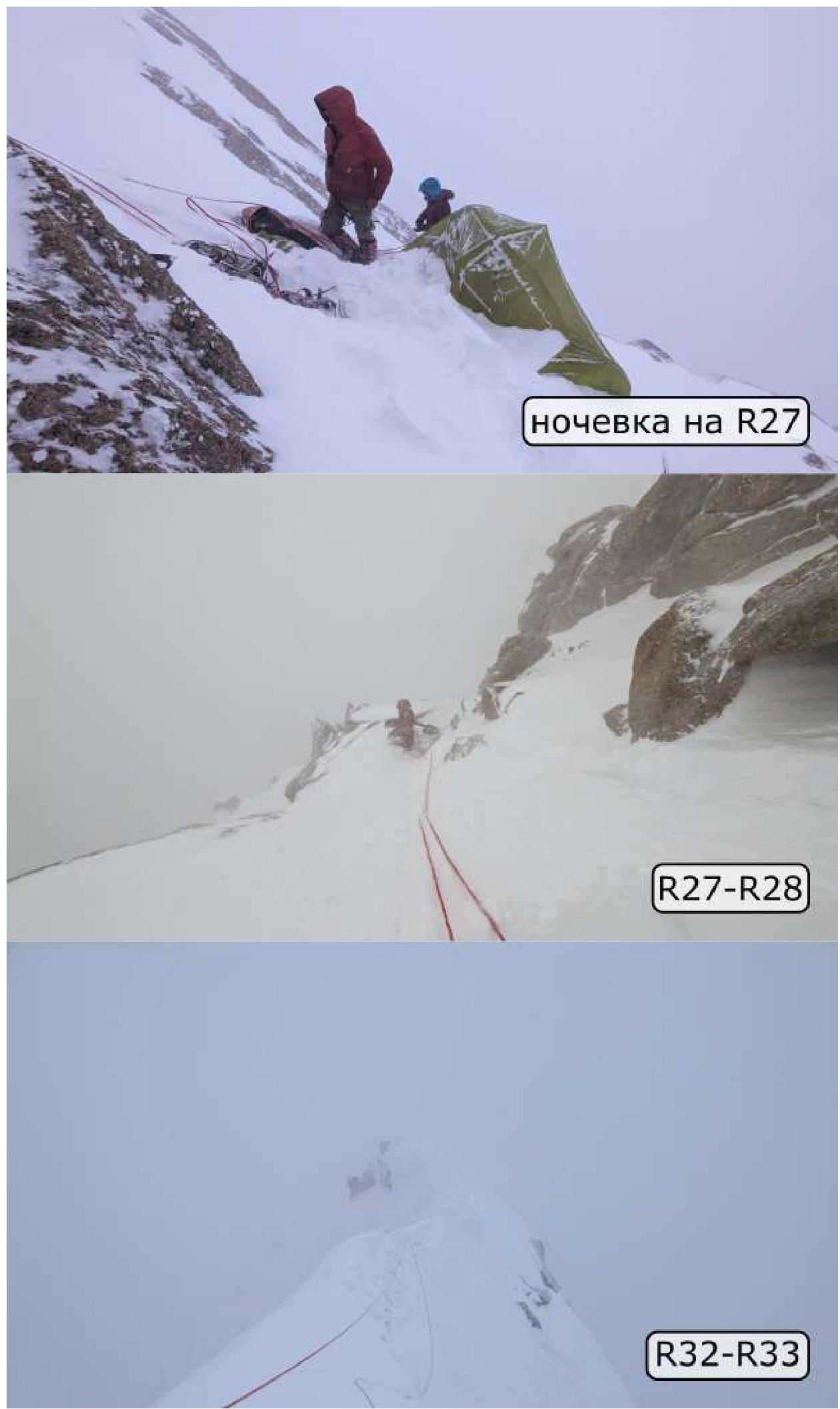
At 21:00, the team decided to build a platform where they had reached. "Lamb brows" mixed with sloping ledges. There were no flat areas. After the evening cooling, the snow was loose and dry. It was difficult to build, and the snow did not stick well. It took more than 4 hours to complete the construction work.
August 26, 2023
The weather had deteriorated significantly. A lot of snow had fallen overnight, and it was still snowing in the morning. The team decided to wait out the weather in the tent.
The snow did not stop during the day. Small avalanches came down the slope, sometimes covering the tent and pushing it away from the slope.
Every 4 hours, it was necessary to go out, dig out the tent and equipment. There were no shovels, so they had to dig out the tent with helmets.
August 27, 2023
In the morning, the weather had slightly improved. The intensity of the snowfall had decreased, but a strong wind had picked up, with drifting snow cutting at the face and eyes. Nevertheless, the team decided to continue moving.
From the tent site, they climbed up snow-ice fields. The snow condition was unstable. Small avalanches constantly came down from under the leader's feet.
Further, overcoming small walls, they exited to a small couloir. They kept to its left side, with insurance on rocky "islands", and exited to a ridge in the form of a "knife". Visibility was low. They had to move carefully. They approached a rock wall.
Then, through a series of walls and corners-cracks, they continued moving up.
They passed under steep snow fields. Due to the abundant snowfall, the snow condition was unstable and dangerous. Insurance was mandatory!
At the end of the snow field, there was a huge stone as a route landmark. They bypassed it on the left. It was necessary to be very careful, as avalanches came down from above, which were collected by a funnel near the stone.
They exited to a snow ridge-"knife". They descended into a hollow. The time was 13:00.
In a snowstorm, when the team reached the hollow, they decided to spend the night there.
Under the wind, they set up a tent. All night it snowed.
At 4:00, they woke up due to a lack of oxygen - the tent was almost buried under snow, and they tried to open the entrance, but it was blocked by snow. They decided to cut the tent with a knife to get out. Through a small cut in the entrance, they climbed out of the tent and dug it out with helmets.
August 28, 2023
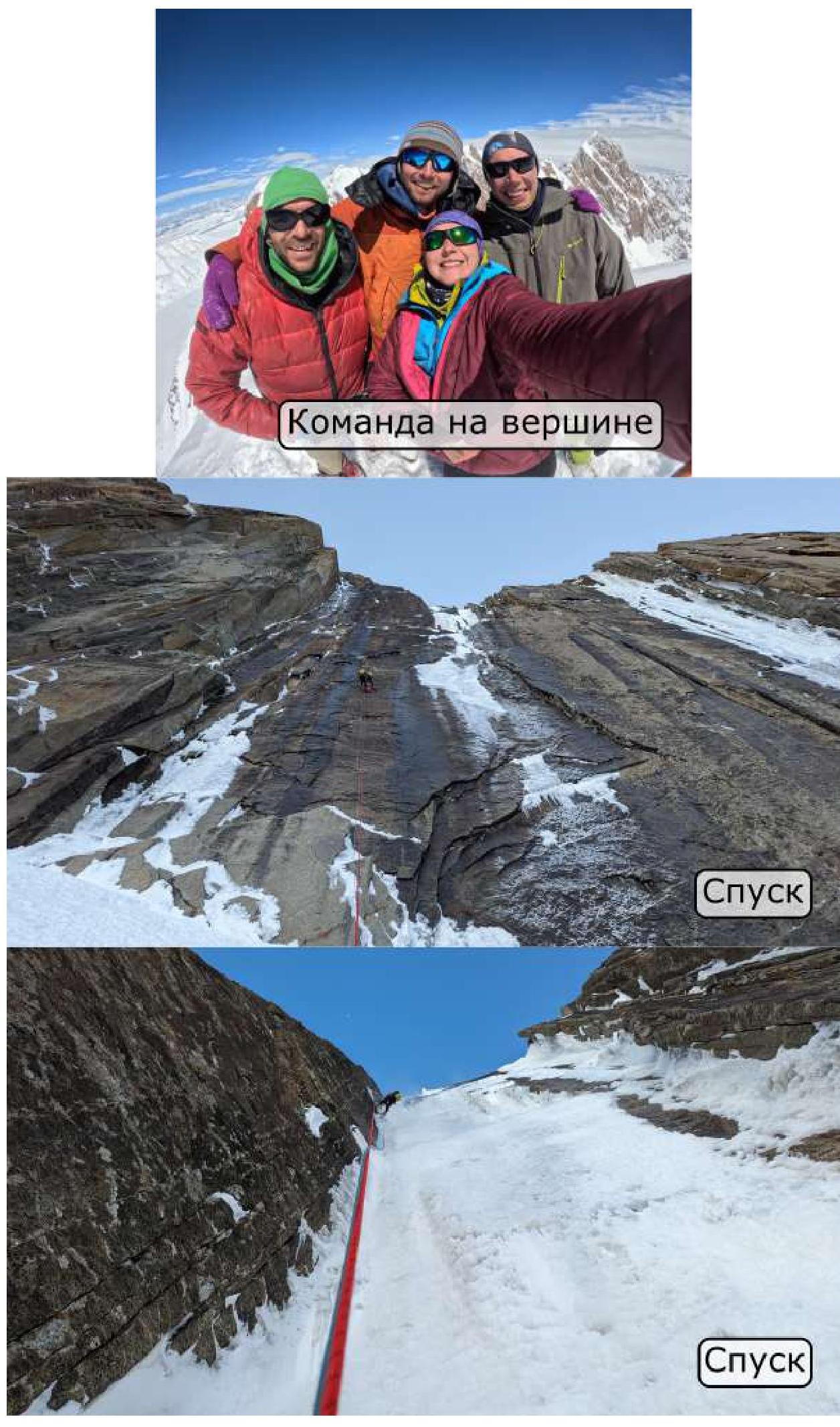
By 10:00, the snowfall had stopped, and the sun finally came out. They climbed out of the hollow onto the snow ridge - and realized that the summit was right there! It turned out that their overnight stay was only 15 m away from the summit. Thus, the team completed the first ascent of Peak Uluun! For about an hour, they enjoyed the excellent views and took photos. They roughly understood the direction of the descent but planned to descend the next day.
Via satellite communication, they received a forecast - a sharp deterioration in the weather was expected. After lunch, a hurricane began, lasting more than 8 hours. With the first gust of wind, the tent began to tear at the cut entrance. All night they held the tent by hand to avoid being left on 5500 m without protection in a hurricane. By morning, the wind had died down - they managed to somehow repair the tent.
August 29, 2023
The weather improved, and the team decided to begin the descent.
The first 10 ropes were descended on ice screws.
Reaching the flattening of the S ridge of Peak Uluun, the team decided to descend to the E:
- first along the ice slopes and rocky "islands";
- but soon the wall became much steeper - the last 200 m were descended along sheer rocky "mirrors".
After descending to the glacier, the snow condition was poor. It was not possible to "track" the path, as the snow had a hard crust on top and was soft inside - they sank up to their hips, and then the ice crust prevented them from pulling out their legs.
The only effective method of movement was on their knees, with a "cowbell" tied behind them on short ropes. The team had to crawl 2.5 km on all fours to the base camp. The journey took 4 hours and 4 pairs of pants torn on their knees. They arrived at the camp after 2:00.
Due to the bad weather that lasted more than 4 days and the huge amount of snow that fell:
- the base camp was completely buried under snow;
- the tents were not visible;
- it was necessary to search for them and then dig them out.
On the site, they decided that due to the сложившейся situation, it was necessary to end the expedition earlier, as:
- the return journey could take much longer;
- the passes became avalanche-prone.
Weather Conditions
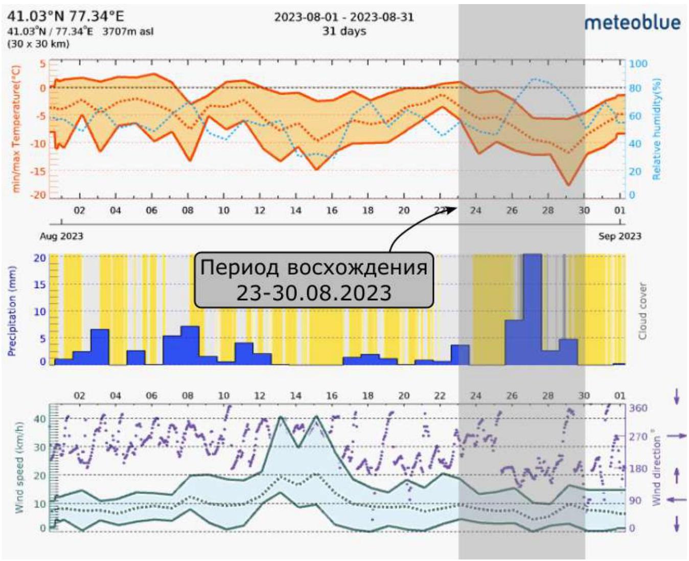
Ascent period August 23–30, 2023
Safety Assessment of the Route. Recommendations for Future Climbers.
We consider the route we passed to be logical, relatively safe, and interesting. No rockfall was observed during the observation and passage of the route. The condition of the route strongly depends on the weather. We had prolonged bad weather, and the likelihood of avalanches was quite high, especially in the upper part of the route.
Future participants should take into account the physically challenging approach to the base camp.
The approach to the route is not complicated if the snow condition is good. It is not necessary to carry water, as there is plenty of snow around.
In addition, future participants should consider that there are no good ledges for overnight stays. The team built all the platforms (except for the overnight stay in the hollow under the summit) themselves.
In terms of character and complexity, the route is category 6A according to the Russian classification.
If the weather window is large enough and the rock is dry, many sections can be climbed.
Recommendations for equipment:
- a set of "nuts";
- anchor hooks;
- rock "skyhooks";
- rock shoes (if there is a good weather window);
- crampons;
- ice screws;
- ice axes.
For weather forecasting and emergency communication, a Garmin InReach GPS messenger was used.
Photo Report

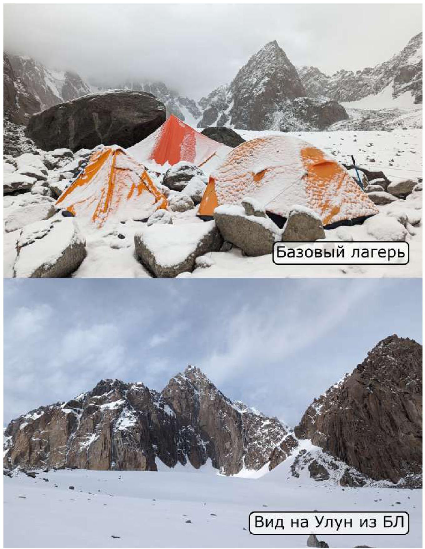
View of Uluun from BC
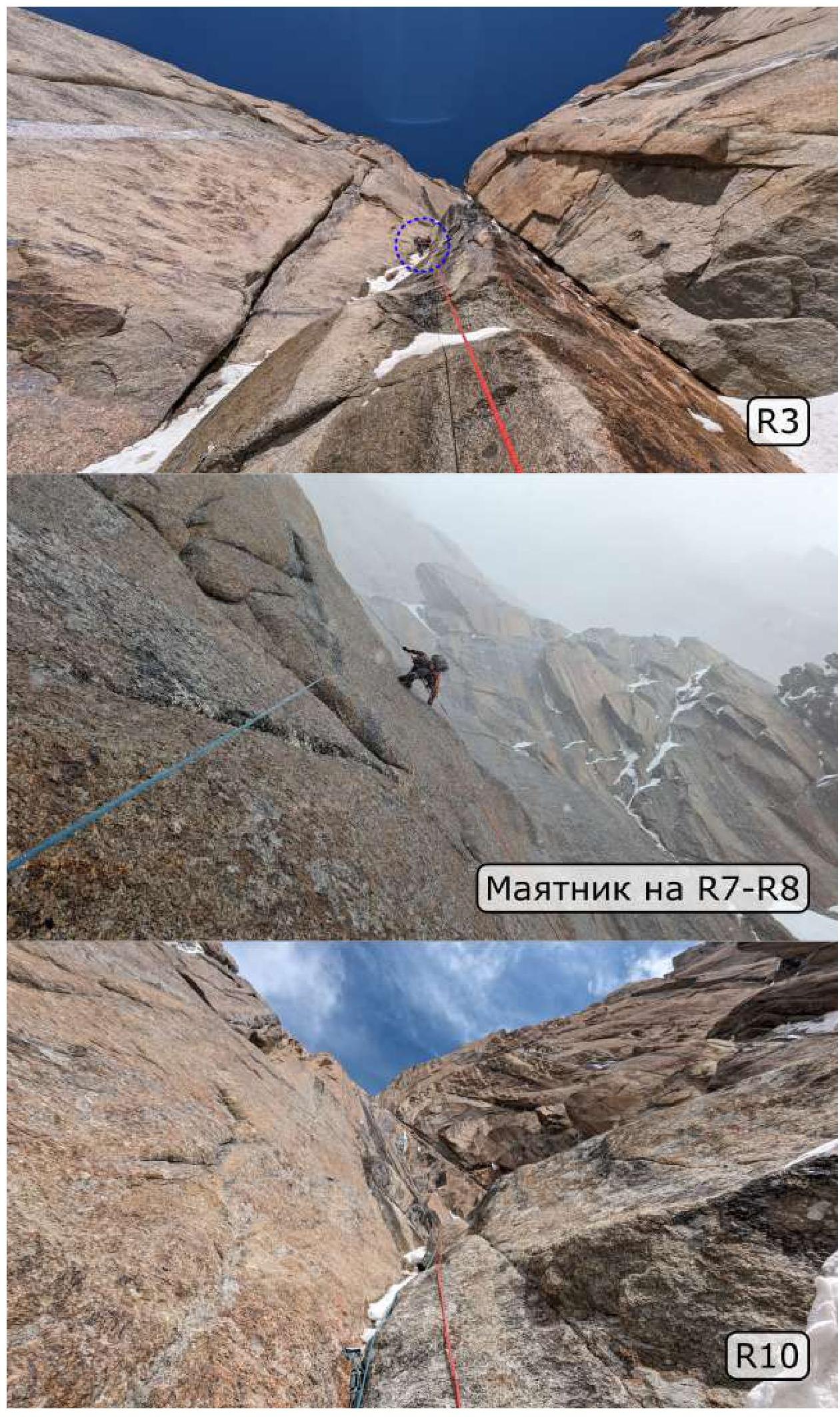
Pendulum on R7–R8
R14–R15
View from R21
 (R27–R28)
Comments
Sign in to leave a comment