Passport
I. Class — technical 2. Tian Shan, Western Kokshaal-Too 3. Pik Podmoskovny via North Ridge 4. Proposed 5B category, first ascent 5. Elevation gain 1133 m. Distance 1250 m.
Distance of sections with 5–6 category difficulty 730 m, including 120 m of 6 category. Average steepness of the main part of the route 65°.
-
Pitons driven: rock — 32/3, bolted — 0/0, chocks — 51/8, ice screws — 12/0
-
Team's travel time: 24 hours and 3 days.
-
Night bivouacs: 1 — on a col below the route, 2 — on the summit, lying down
-
Weather conditions: complex
-
Team captain: Akhmatov F.A., Candidate Master of Sports Team members: Vikulin S.I., Candidate Master of Sports; Shamonov I.S., 1st sports category; Romanov V.A., 1st sports category.
Approach to the route, overnight stay on the col — August 10, 1993. Departure for the route — August 11, 1993. Summit — August 11, 1993. Return — August 12, 1993.
 Profile of the wall from the right. Taken on August 10, 1991 at 10:00 (shot point #6). H = 3900 m; L = 1 km.
The weather in spring and summer 1993 in Kyrgyzstan was particularly unfavorable: regular precipitation, often very heavy, lowered average temperature. As a result, snow cover and especially glaciation were above average.
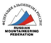

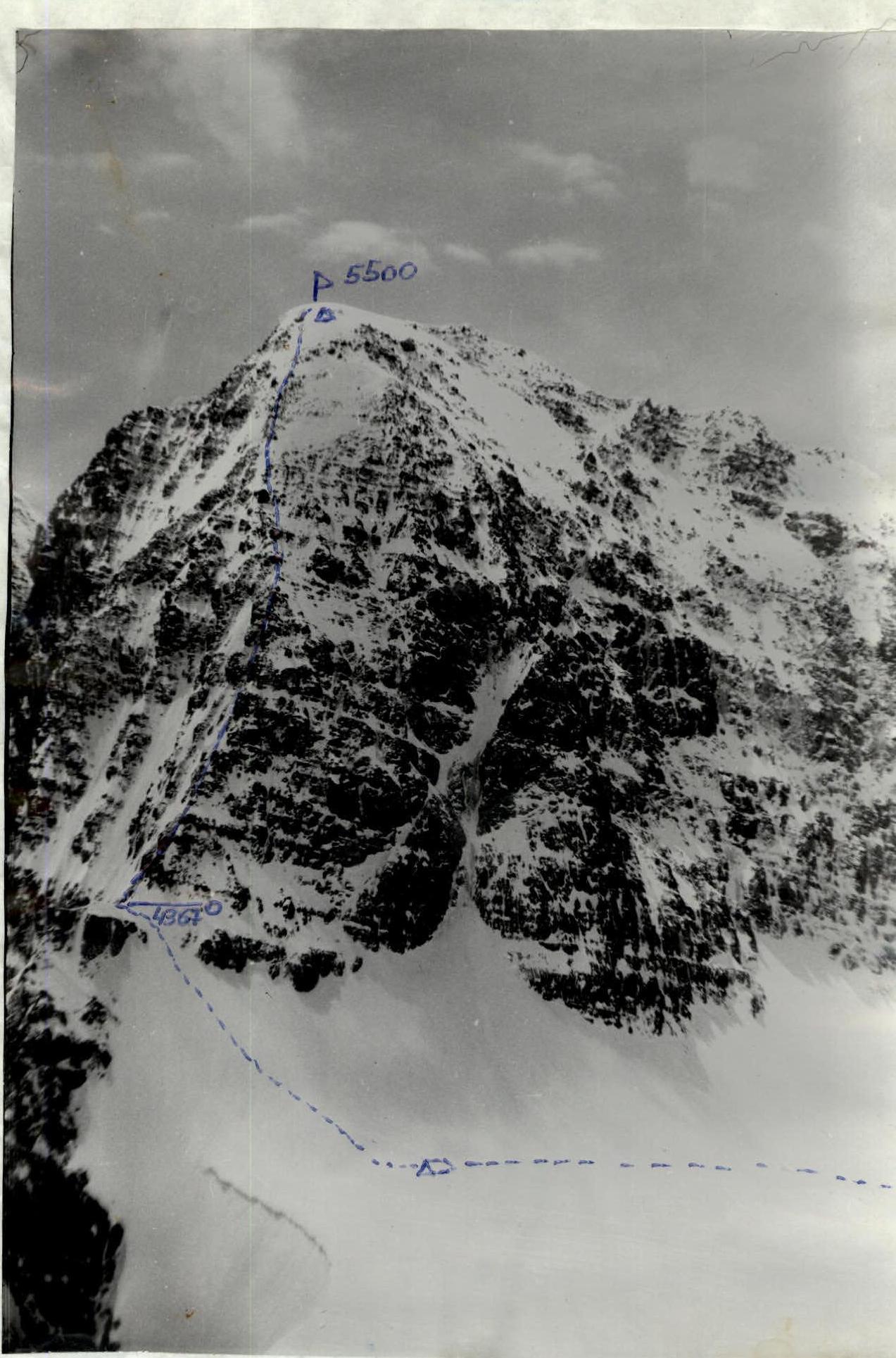 Photo: panorama of the area, including peaks Langepe, Podmoskovny (5500 m) and Zinaida (5560 m), as well as the observers' camp (shot point #5). Taken in 1969. H = 5000 m; L = 5 km.
 Technical photo of the summit. Taken on August 9, 1993 at 11:00. H = 4500 m; L = 15 km.
The weather in spring and summer 1993 in Kyrgyzstan was particularly unfavorable: regular precipitation, often very heavy, lowered average temperature. As a result, snow cover and especially glaciation were above average.
Chon-Turasu valley. Scale 1:100000.
Brief overview of the ascent area
Pik Podmoskovny is located in the Western Kokshaal-Too range. Climbing development in this area began with the Letavet expedition (1932). In 1969, an expedition of climbers from Moscow region worked in the area and traversed peaks Kibalchicha, Koroleva, and Tsander (4th place in the USSR championship). In the early 1970s, an expedition of Kazakh climbers from the "Enbek" society visited the area around peak Dankova. In the late 1980s, Kazakh expeditions led by Popenko, Valiev, Ilyinsky, and Sidelnikov (1989) worked in the more accessible western part of the range, in the area of peak Kzyl-Asker.
The Western Kokshaal-Too range is characterized by harsh climatic conditions and frequent bad weather. The rocks are of two types: monolithic smoothed black "ram's foreheads" with few thin cracks, or monolithic outcrops with few holds but wide cracks. The nature of the rocks, as well as the abundance of ice, greatly complicates the organization of protection and requires the use of the entire range of rock climbing equipment: a diverse set of chocks (including very large ones), rock pitons, including blades and friends.
The most convenient way to approach the Western Kokshaal-Too range is undoubtedly by helicopter via the cities of Bishkek or Karakol (Przhevalsk). There are also two possible options for approaching by car (we used the first option):
- Bishkek — Issyk-Kul — Barskoon settlement — Barskoon and Suek passes — into the Naryn river valley to the Karasai settlement, where a border outpost is located, then through the Barkaldai ridge — into the Uzengue-Gush river valley and further up to the Chon-Turasu river — a tributary of Uzengue-Gush. The entire journey from Bishkek to the base camp takes 2 days (500 km).
- Bishkek — Naryn — area of peak Kzyl-Asker — upper reaches of the Uzengue-Gush river.
The base camp was located 7 km from the mouth of the Chon-Turasu river.
The weather in spring and summer 1993 in Kyrgyzstan was particularly unfavorable: regular precipitation, often very heavy, lowered average temperature. As a result, snow cover and especially glaciation were above average.
Preparation for the ascent
To prepare for participation in the 1993 CIS Climbing Championship, the Coaching Council of FAMO developed a training program for the Championship, which included programs for technical, physical, and psychological preparation.
Initial familiarization with Pik Podmoskovny was done using photographs taken in 1969 by an expedition of climbers from Moscow region. Upon arrival in the area of Pik Podmoskovny, a systematic reconnaissance of the proposed route was carried out during ascents to peaks Zinaida and Tsander. The nature of the north ridge was studied, options for ascending to the proposed route were examined, as well as possible descent paths from the summit. Directly before departing on the ascent, the route was observed for a day using a 20x telescope.
To ensure safety, it was planned to maintain visual observation of the team by a group of 2–3 people, including a doctor, from a camp under the slopes of peak Koroleva. Communication between the team and the observation group was to be carried out using compact VHF radios "Indurmtechnika", and between the observation group and the base camp — using more powerful VHF radios "Rus".
The sports form of the team members was optimal by the start of the ascent. This was facilitated by good acclimatization obtained during training ascents (to peak Zinaida, 5560 m; to peak Burasha, 4900 m). The training ascents also allowed the team to get accustomed to the characteristics of the given area and the nature of the rock terrain. Regular training during preparation for the season also played a significant role. Particularly important were sporting ascents in Crimea, in the Laspi area (Kush-Kaya mountain).
Ascent schedule
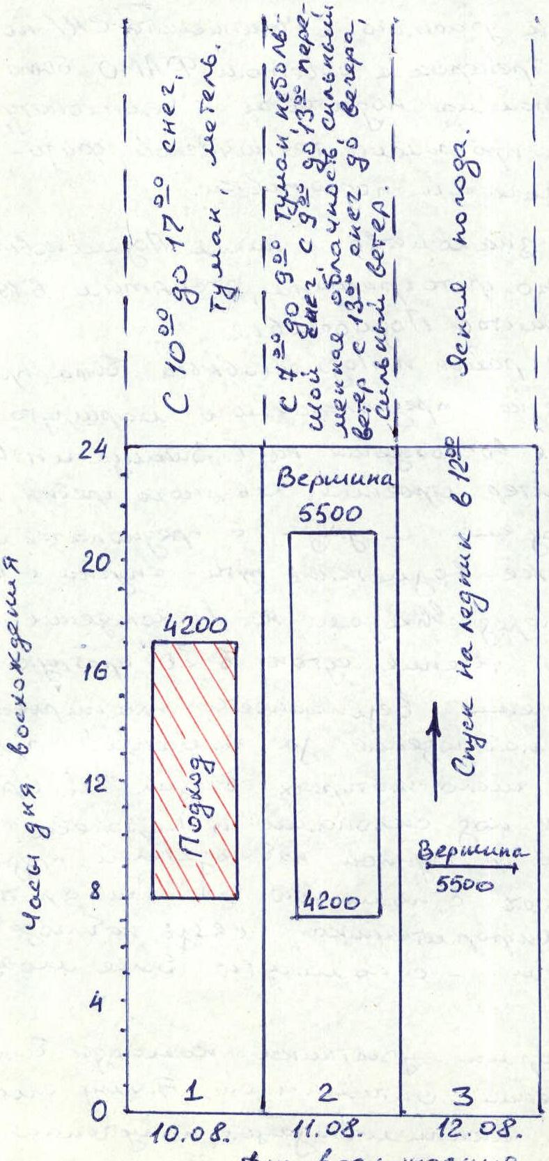
The schedule shows the time spent on the ascent, by day:
- Day 1 (August 10): Approach. Duration from 10:00 to 17:00. Maximum height 4200 m.
- Weather: From 10:00 to 17:00 — snow, fog, blizzard.
- Day 2 (August 11): Ascent to the summit (5500 m).
- Weather: From 7:00 to 9:00 — fog, light snow. From 9:00 to 13:00 — variable cloudiness, strong wind. From 13:00 — snow until evening, strong wind.
- Day 3 (August 12): Descent to the glacier at 12:00 from the summit (5500 m).
- Weather: Clear.
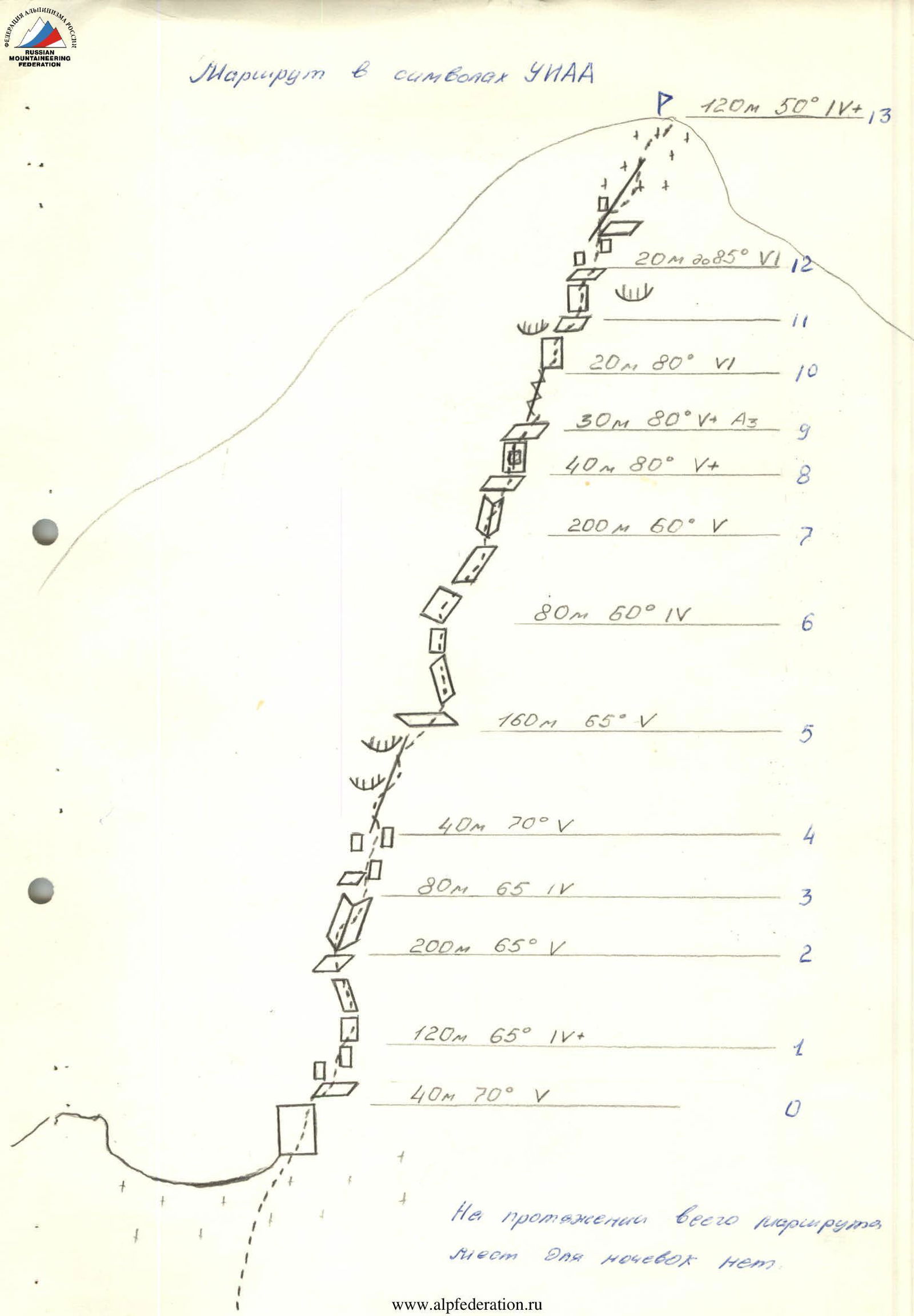
Route in UIAA symbols
Description of route sections:
- R0: 40 m, 70° (category 5)
- R1: 120 m, 65° (category 4)
- R2: 200 m, 65° (category 5)
- R3: 80 m, 65° (category 4)
- R4: 40 m, 70° (category 5)
- R5: 160 m, 65° (category 5)
- R6: 80 m, 60° (category 4)
- R7: 200 m, 60° (category 5)
- R8: 40 m, 80° (category 5)
- R9: 30 m, 80° (category 5, A3)
- R10: 20 m, 80° (category 6)
- R11: (connecting section)
- R12: 20 m, 85° (category 6)
- R13: 120 m, 50° (category 4)
There are no places for overnight stays along the entire route.
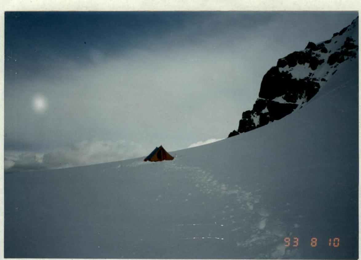
 Overnight stay on the col below the summit. Taken on August 10, 1993 at 18:30. Height 4200 m. Cassio camera, F = 35 mm.
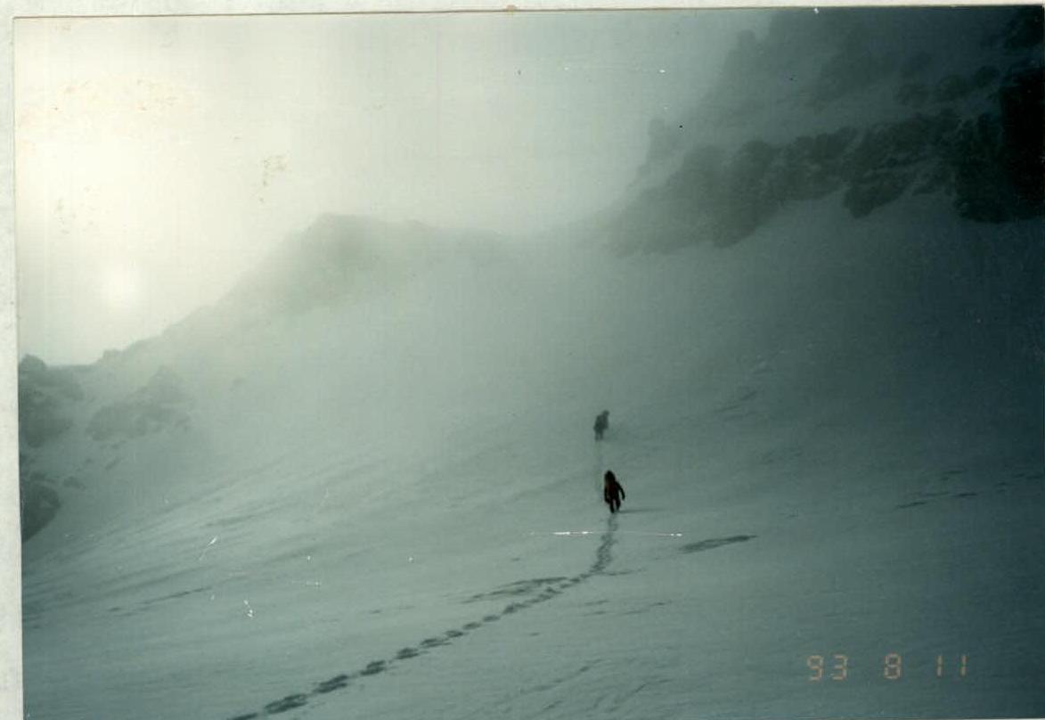
Departure for the route. August 11, 1993. Taken at 7:30. Light snow, fog.
The weather in spring and summer 1993 in Kyrgyzstan was particularly unfavorable: regular precipitation, often very heavy, lowered average temperature. As a result, snow cover and especially glaciation were above average.
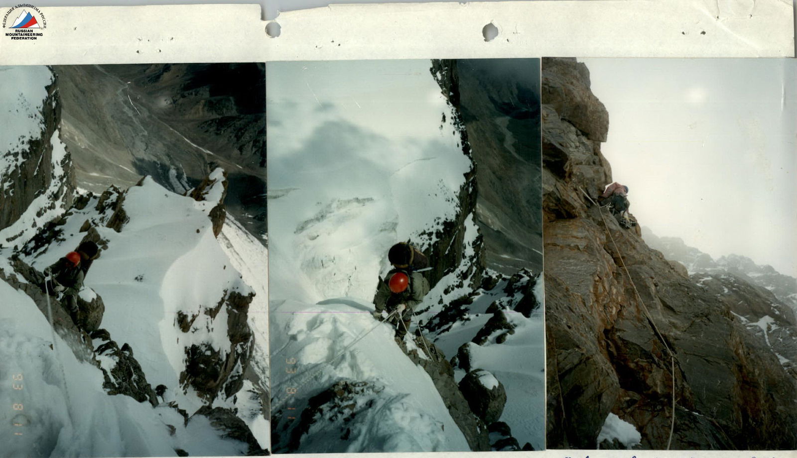 V. Romanov on the fixed rope section R4–R5. Taken on August 11, 1993 at 10:30.
V. Romanov on the fixed rope section R1–R2. Taken on August 11, 1993 at 9:00.
F. Akhmatov on section R9–R10. Taken on August 11, 1993 at 15:00. Fog, light snow.
The weather in spring and summer 1993 in Kyrgyzstan was particularly unfavorable: regular precipitation, often very heavy, lowered average temperature. As a result, snow cover and especially glaciation were above average.