
Ascent Passport
- Region: Central Tian-Shan, South Inylchek Glacier
- Peak name: Peak Pobeda, route name — Pobeda Main via v. Vazi Pshaveli with pass. Diky
- Proposed — 5B category of difficulty.
Route character: combined
- Route height difference: 3000 m
Route length: Section length: Average steepness of the main route part:
- "Hooks" left on the route: total; including pitons. Hooks used on the route: stationary pitons; including ITDs.
- Team's walking hours: 8 days
- In a rope team: Grigoryev Mikhail Gennadievich, MS. Nikitin Andrey Borisovich, CMS.
- Coach: Stepanov Igor Vasilievich, MS
- Departure on the route: 9:00, August 17, 2003. Summit ascent: 14:30, August 21, 2003. Return to BL: 21:00, August 24, 2003.
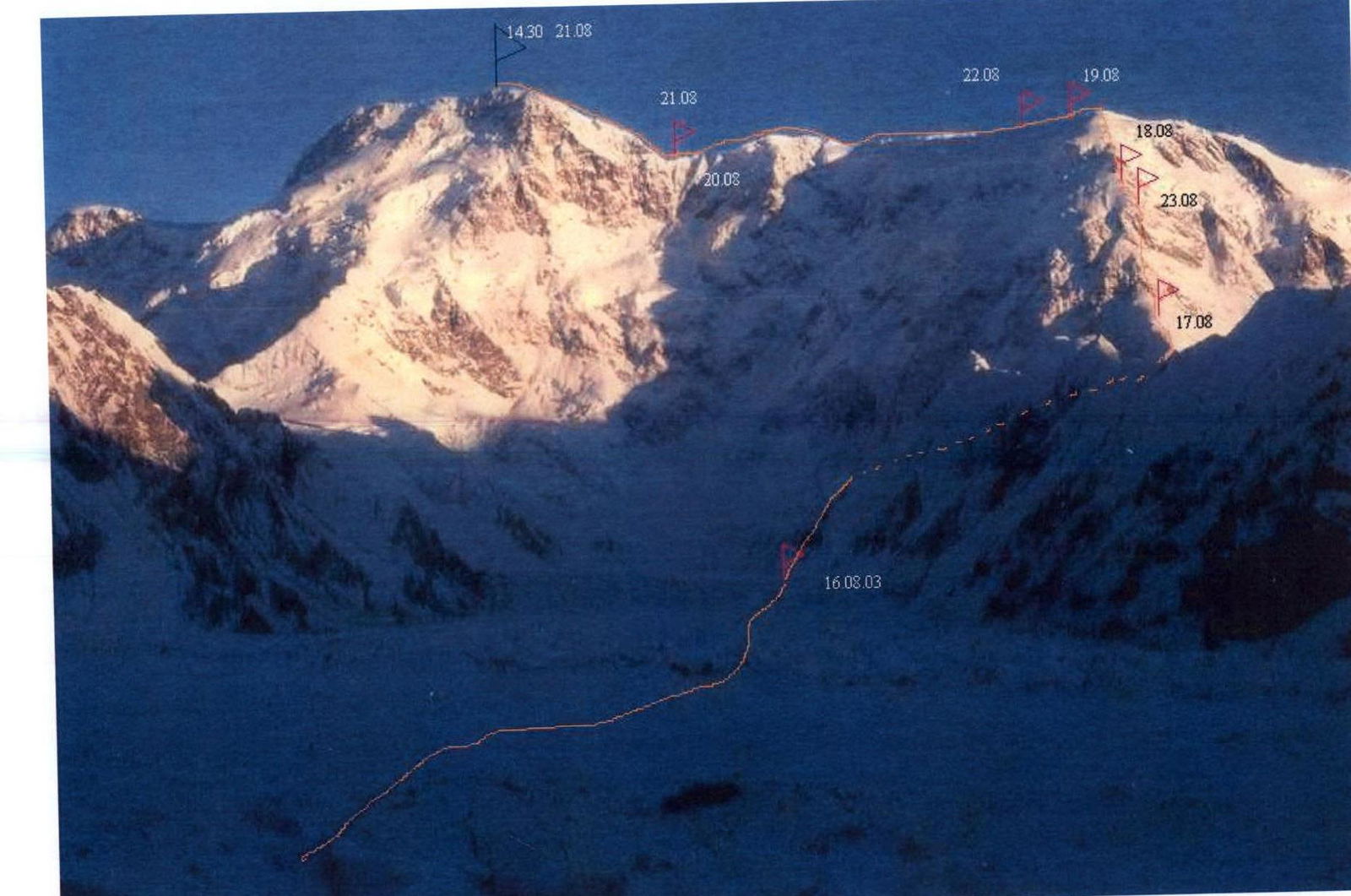
On the next page, there is a general photo of the summit with the route marked on it.
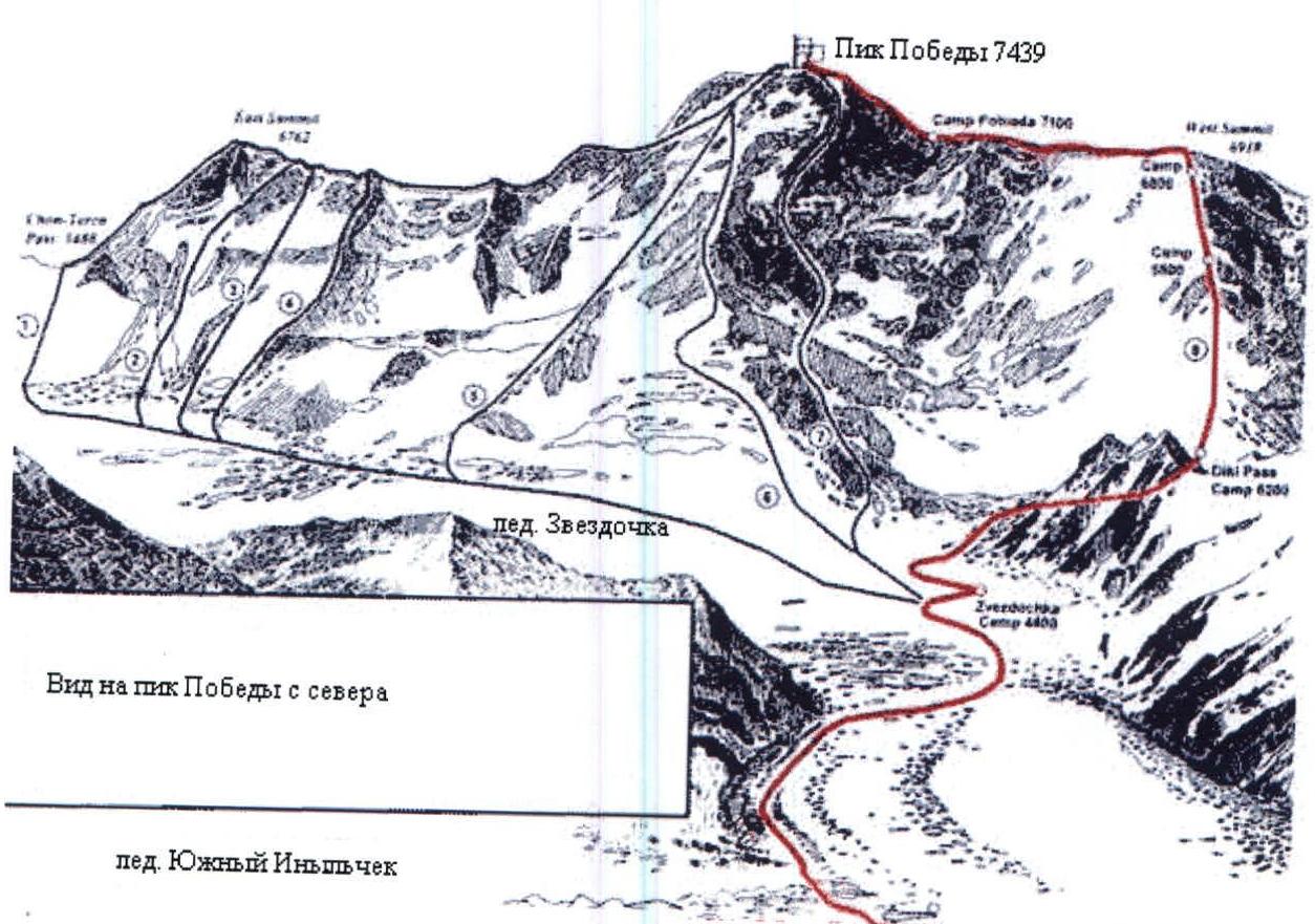
General scheme of the p. Pobeda massif with nearby routes
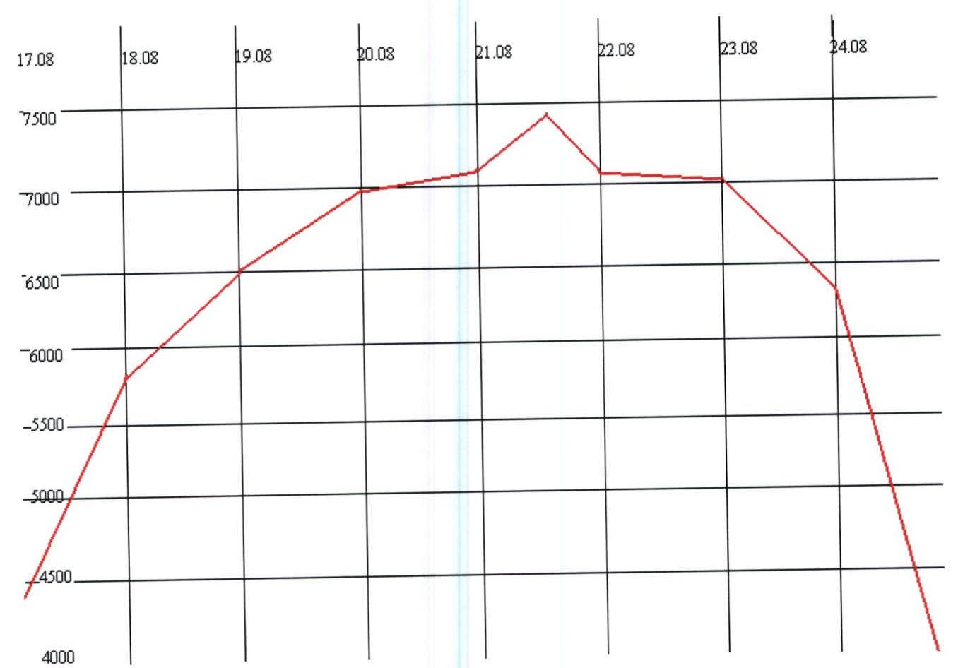
Ascent Graph
Team's Tactical Actions
The team arrived in Mayda-Adyr on July 25, 2003. To gain initial acclimatization, they decided to go to the base camp on l. South Inylchek on foot. The transition took 4 days. On the evening of July 29, they arrived safely at the base camp.
The first acclimatization exit was made on the saddle between p. Chapayev and Khan-Tengri. As the second acclimatization exit, they made an ascent to Khan-Tengri.
Taking into account the experience gained during previous exits, the rope team adhered to the following ascent schedule:
-
August 16 — departure under the route at 12:00 for night camps at 4400 m. Near the camps, they met two hiking tourists from Moscow region, g. Dmitrov. While setting up the tent, they heard cries for help — one of the tourists fell into a crevasse. They had to do rescue work, and then feed and put the tourists to bed — they didn't take any food with them for the hike, and sending them down in the evening without a rope was dangerous.
-
August 17 — at 9:00, after seeing off the "uninvited" guests, they started on the route. By 17:00, they reached 5800 m via a decent trail. A Danish duo had been camping there for the second day — they took a rest day — one of them had a headache. Rescuers with Merab and Spanish Maria were descending, and a couple of hours later, Dima Komarov with a Basque.
-
August 18 — they departed at 8:00, overtook the Danes, and met V. Panasyuk with a Swiss who turned back due to the wind. Strong wind. The Danes also turned back. By 16:00, they reached the night camps under the "triangle" and decided to camp there.
-
August 19 — at night, the strong wind tore the pockets for attaching the tent poles. They had to remove all the poles and sleep in the tent like in a bag. In the morning, they repaired the tent and departed around 11:00. By 16:00, they ascended to v. Pshaveli and, after walking a bit along the ridge, decided to stop.
-
August 20 — they departed at 9:00. The ridge to the "camel's hump" was in decent condition, and the "hump" itself turned out to be the most technically difficult section of the route. Due to a large cornice, they had to traverse the "hump" along a fairly steep slope, and the sun at its zenith made the snow soft, which clogged the crampons. They had to clear the snow from the crampons at every step. By 14:00, they reached the "obelisk" and saw a group of 8 people led by Gleb Sokolov descending from the summit. They set up a tent and had tea with the newcomers. The guys said they were already on the route for the 12th day, while they had planned to finish in 10. They shared some cubes and glucose. In the evening, they repaired the tent again.
-
August 21 — they departed at 8:30. Visibility was 150–200 m, with strong wind and snowstorm. Around 11:00, they left a backpack with a radio on the ridge, hoping to return to it before the daily communication session. Visibility kept worsening, and near the summit, it was 10–15 m. At the next "bump," they thought it was the summit — but there was no cairn. They went further and reached the summit in another half hour. Some kind of journal was sticking out of the cairn. By that time, the weather had completely deteriorated: strong wind was blowing, and there was no desire to write a note or retrieve Sokolov's note. They turned back. By 17:00, they returned to their tent near the "obelisk." The snowstorm intensified, and snowdrifts formed around the tent.
-
August 22 — The snowstorm ended by 10:00. The tent was in the center of a neat round pit about one and a half meters deep. They departed at 10:30. After an hour of difficult trekking, they stopped to review what else they could get rid of. They threw away some hardware, a thermos, and other trifles, leaving themselves 15 m of rope. By 18:00, they stopped for the night, not reaching their previous campsite near v. Pshaveli.
-
August 23 — In the morning, they continued trekking. Reaching v. Pshaveli, they saw that it was impossible to descend directly due to a large newly formed cornice. They had to descend further along the ridge and then carefully traverse back along the slope, trying not to undercut it. Fortunately, the slab went down below their tracks. Due to this maneuver, their coach Stepanov I.V., who was supposed to watch their descent from v. Pshaveli from the base camp with binoculars, didn't see them and raised a slight alarm. Around 17:00, they stopped for the night at 6400 m.
-
August 24 — They departed at 8:00. At 15:30, they met the support group on the Zvezdochka glacier and were back at the base camp by 21:00. The only photo on the route was taken by Dima Komarov descending down at an altitude of 5800 meters.
See (http://www.mountain.ru/world_mounts/tien-shan/2003/Pobeda_Komarov/ ↗)
November 9, 2003.
Comments
Sign in to leave a comment