XVIII EAAC (CIS) Championship in Alpinism, High-Altitude Technical Class 2009
Description of the ascent to Peak Pobeda Main (7439 m) via the Northeast Counterfort, 6A category.
The route was climbed by a team from FASIL St. Petersburg.
Team captain: Viktor Aleksandrovich Koval. Team coach: Oleg Viktorovich Kapitanov.
Ascent Passport
- Central Tian Shan, Kokshaal-Too range, South Inylchek, section No. 7.5 of the route classifier for mountain peaks.
- Name of the peak: Pobeda Main (7439), name of the route: via the Northeast Counterfort (V.Zhuravlev, 1990).
- Category of complexity: 6A.
- Nature of the route: combined.
- Height difference on the route: 2635 m (by altimeter).
Length: on the ascent (up to the ridge crest) – 3304 m; length of sections with 5th category complexity – 1785 m; 6th category complexity – 119 m. Average steepness of the main part of the route – 53°.
- Number of pitons hammered (in the denominator for ITO):
rock: 4/0 protection elements: 0 ice: 97/0 snow anchors: 3/0 bolts: 0 Total artificial points of support (ITO) used: 0.
- Team's travel hours:
ascent: 46 hours, 6 days descent: 20 hours, 3 days.
- Leader: Viktor Aleksandrovich Koval, 1st sports category.
Participant: Sergey Vladimirovich Kondrashkin, 1st sports category.
- Coach: Oleg Viktorovich Kapitanov, Master of Sports, 1st category instructor.
- Departure to the route: 9:30, August 2, 2009.
Reached the summit: 15:10, August 7, 2009. Returned to Base Camp: 16:30, August 9, 2009.
History of the Route, Description of the Area
The route to Peak Pobeda Main via the Northeast Counterfort was first climbed by a team led by Master of Sports Viktor Zhuravlev from Samara (V. Zhuravlev – leader, participants – I. Benkin, A. Volkov, V. Zhestkov, V. Zakharov, V. Nefedyev, S. Penzov) in 1990, which won third place in the USSR Championship in the high-altitude class. The route was repeated only once by a team led by Sergey Penzov in 1997 (S. Penzov – leader, participants – M. Ishutin, M. Strelkov), which won first place in the Russian Championship in the high-altitude technical class.
Tactical Actions of the Team
The team chose the route to Peak Pobeda Main via the Northeast Counterfort as the object for their ascent back in 2008. In August 2008, a team of four, including the participants of the current ascent, attempted to climb the route but had to stop at a height of 5800 meters due to an illness.
The 2008 attempt allowed the team to observe the route, assess its technical complexity, determine the necessary tactics, and prepare the required equipment.
Based on the 2008 attempt, it became clear that:
- the ascent is only possible if the route and adjacent slopes are not heavily snowed;
- due to highly unstable weather conditions, the ascent should be made in alpine style and at the highest possible pace;
- it is possible to climb the route as a team of two.
To ensure safe and rapid passage, good acclimatization was necessary. The team arrived at Achik-Tash for acclimatization and climbed Peak Lenin (7134 m). Only after this did the team arrive at the base camp on the South Inylchek glacier.
The final decision to ascend Peak Pobeda Main via the Northeast Counterfort was made after consulting with the head of the "South Inylchek" Mountain Camp, D. Grekov, and the rescue team regarding the snow and avalanche situation in the area.
Both V. Zhuravlev's team and S. Penzov's team chose to descend via Abalakov's route along the northern ridge (deviating onto this route is possible after reaching 7100 m). This descent route allowed both teams to ascend lightly from 7100 meters, leaving their bivouac equipment on the pre-summit slope. However, this route is objectively very avalanche-prone and requires a good knowledge of the route and terrain. Therefore, our team chose the classic route via Peak Vazha Pshavela (Western Pobeda) and then along the northern edge to the Diki Pass (D. Medzmariashvili's route, 1961, 5B category) for the descent. This route is much longer and requires traversing the entire summit massif of Peak Pobeda. However, several teams work on the classic route, which can provide assistance in case of an emergency during the descent.
Analyzing the reports of both teams that had climbed the route and our own experience from the previous year, we developed the following tactical plan: 1-2 days – approach to the route; 3-8 days – climbing the route; 9-10 days – descending from the summit via the classic route through Peak Vazha Pshavela to Base Camp. 11-12 days – reserve days.
Description of the Route
August 1 – Day One
At 6:30, the team started approaching the route from the "South Inylchek" Mountain Camp. The path lay along the Zvezdochka glacier towards the first camp on the classic route under the Diki Pass. The glacier was closed, and the team moved in ropes. About 300 meters before the first camp, they turned left and moved towards the upper reaches of the Zvezdochka glacier, heading for the Chon-Toren Pass. The path lay on the right side of the glacier, as the left side was heavily crevassed. After turning, the snow was knee-deep. Numerous closed crevasses were encountered. The team moved at a safe distance from the slopes of Peak Pobeda to avoid avalanches and icefalls. After 14:00, the snow became very soft, making movement difficult. At 19:30, they stopped for the night on the glacier at a safe distance from the slopes of Peak Pobeda (height – 4500 meters).
August 2 – Day Two
At 5:30, the team continued their approach to the route. Movement was in ropes. Within an 800-meter radius of the Northeast Counterfort, the glacier was heavily crevassed with crevasses over 10-15 meters wide. By 9:30, they reached the base of the counterfort (height – 4800 meters). Given the highly unstable weather, they decided not to make an additional night stop under the counterfort, as previous teams had done. They began work on the route, climbing a steep snow slope (150 meters), followed by an 8-meter ice wall (80°), then 70 meters of steep snow slope, and a 6-meter vertical ice wall under an overhanging serac. Twenty meters of traversing and 15 meters of very steep snow-ice slope (80°) led to a sharp snow ridge. Forty meters up, on the right side of the ridge (avoiding cornices on the left), they reached a gentle snow slope (180 meters). The snow was 40-50 cm deep, and movement was simultaneous. The counterfort was again disrupted by a wide ice crevasse, followed by a very steep (80°) snow slope (50 meters) under an overhanging serac. They descended into the right part of the crevasse and started ascending a steep snow slope, organizing reliable insurance in the ice to the left of the overhanging serac. From under the serac, they moved left-up (50 meters, 60°) and reached a gentle snow slope (160 meters). They organized a bivouac in a safe ice crevasse (height – 5300 meters).
August 3 – Day Three
At 6:00, they began moving upwards. Along the gentle snow slope, they approached a 15-meter ice wall, which they climbed head-on. Further, along a steep snow slope (snow depth about a meter), they moved vertically up to a rock island. The report of the first ascenders noted that "movement forward was at the limit of human capabilities." From the rock island, they moved right-up along a steep (55°) 140-meter ice slope (hard winter ice) to avoid a huge overhanging ice wall of the first icefall. They entered an ice gully (120 meters, 60°) between the seracs of the icefall on the left and the ridge with cornices on the right. Beyond the gully lay a steep snow slope with very deep snow. They moved straight up between the seracs on the left and the rock island on the right. Due to a snowstorm and lack of visibility, they stopped for the night in a safe ice crevasse (height 6000 meters).
August 4 – Day Four
After the snowstorm ended in the morning, they continued at 8:00. They moved towards the icefall, up a gentle snow slope leading to the ice walls of the hanging glacier, forming a shelf that went right from Peak Armenia towards the massif of Main Pobeda. As they approached the icefall, the slope became steeper. Under the ice walls of the hanging glacier, they moved right-up along a snow-ice shelf to avoid the ice walls. Due to a new snowfall, powder avalanches started coming down. They stopped for the night under the protection of an overhanging rock (height – 6700 meters).
August 5 – Day Five
Starting June 7, 2009, at 7:00, they continued right-up along the inclined snow shelf between the hanging glacier and the wall dropping down into the cirque between their counterfort and Abalakov's ridge. After 130 meters, they reached a wide gap between the ice walls. According to previous teams' descriptions, there should have been a passage through the icefall here. However, 180 meters of very steep snow slope with crevasses and gaps led them under a strongly overhanging ice wall (at least 70-80 meters high). There was no passage through the icefall here. They traversed the slope under the base of the ice wall to the right (200 meters) to a rock island. They moved up to the lower left edge of the rock ridge descending from the summit, first along a steep snow slope (180 meters) with deep snow, then along a gentle slope of hard winter ice covered with a thin layer of snow. They stopped for the night under an overhanging rock (height – 7100 meters).
August 6 – Day Six
Starting at 8:00, they bypassed the overhanging rock on the right along a snow slope (80 meters), then moved straight up towards the rocks resembling a "W" from below. Initially, they climbed a steep winter ice slope (100 meters) with careful insurance on ice screws, followed by a gentle snow slope (170 meters). The entire time, they faced a very strong stormy wind from the west and temperatures around –35 °C. Upon reaching the rocks, they decided to stop for the night, carving out a hollow in the ice for their tent. The night was in a semi-sitting position (height 7300 meters).
August 7 – Day Seven
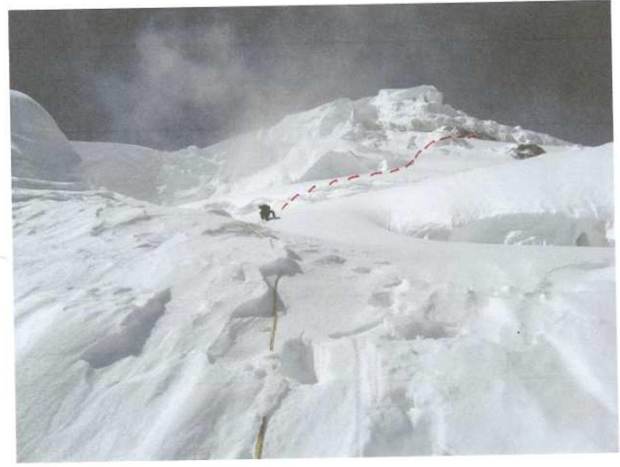
At 7:30, they began moving up a snow gully between the rocks (40 meters), then along a snow slope (170 meters) to the right of the rocks descending from the eastern edge of the summit massif, towards the summit ridge where there were no overhanging cornices. As they approached the summit ridge, the slope became steeper. The final 90 meters to the summit ridge were along broken rocks. After reaching the summit ridge (height – 7430 m), they traversed it to the west to the main summit of Pobeda. Movement was along the Chinese side to avoid huge snow cornices on the northern side. They did not find a summit cairn. After traversing the entire summit massif (about 400 meters), they reached the classic route on the western ridge of Peak Pobeda and began their descent. They set up a night camp under the "Obelisk" rock (height – 7100 meters).
August 8 – Day Eight
They departed at 8:00, moving along the western ridge towards Peak Pobeda West (Vazha Pshavela). After passing the "Camel" pinnacle, they were caught in a snowstorm, making further movement almost impossible due to poor visibility. From Peak Pobeda West, they descended along its northern edge to Camp 2 of the classic route at a height of 5800 meters. They spent the night in a comfortable cave.
August 9 – Day Nine
They departed at 7:30, descending along the snow ridge to the Diki Pass, and then through snow fields and an icefall, they reached the Zvezdochka glacier. By 15:00, they returned to the "South Inylchek" Base Camp.
The team's planned itinerary largely matched their actual progress (the approach took one and a half days, and they began working on the route on the second day).
Some sections of the route in 2009 differed from the descriptions in the 1990 and 1997 reports. The lower part of the route (up to 5200 meters) featured ice walls, crevasses, and seracs that were not present during the 2008 attempt.
The route is considered to merit a 6A category due to its length, logical progression, and the need for thorough tactical planning, physical and technical preparedness, good acclimatization, and high-altitude experience, as well as its diverse mountain relief forms.
- A note from the summit is not provided as the team did not find a summit cairn along the entire length of the summit ridge of Peak Pobeda Main.
- Due to the absence of a summit cairn, photographs are available only from the summit ridge towards China and on the summit ridge at the point of exit from the Zhuravlev route.
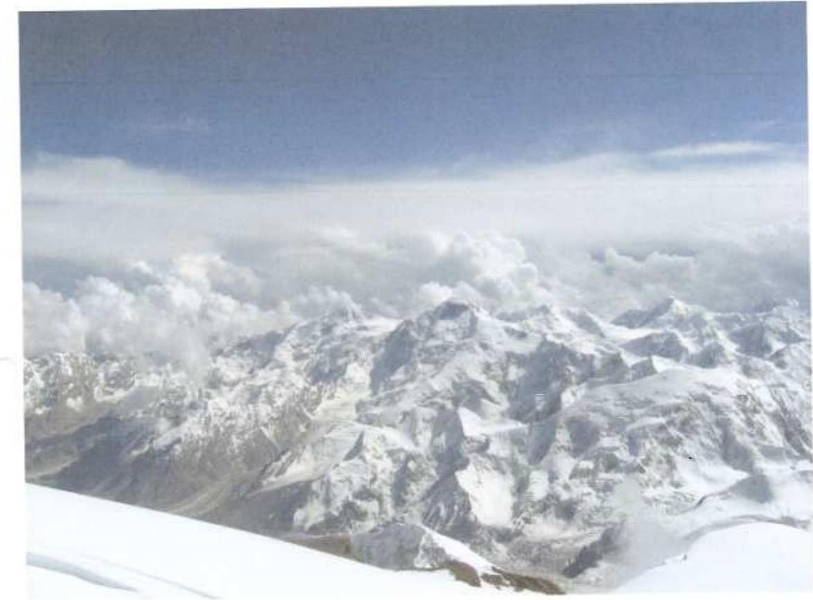
General photograph of Peak Pobeda massif from the slopes of Peak Chapayeva
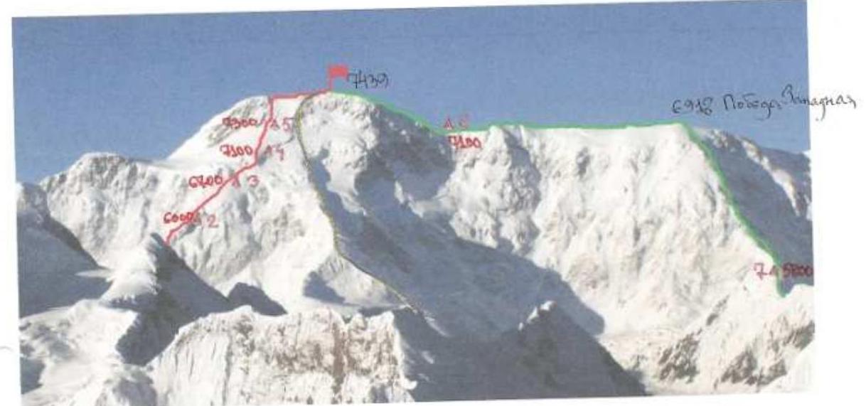
Red line – visible part (from 5800 m) of the team's route along the Northeast Counterfort, 6A category (V. Zhuravlev, 1990). Green line – classic route via Peak Pobeda West along the northern edge from the Diki Pass, 5B category (D. Medzmariashvili, 1961) – the team's descent route.


Descent to the "Obelisk" pinnacle. In the background: the western ridge of the Pobeda massif, "Camel" pinnacle. August 7, 2009, from 7150 m.
Technical photograph of the route. Peak Pobeda from the slopes of Peak Voennykh Topografov.
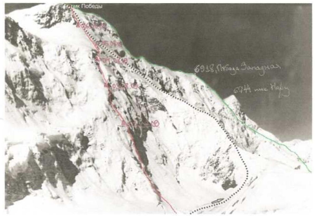
Red line – team's route along the Northeast Counterfort, 6A category (V. Zhuravlev, 1990). Dashed line – route of the first ascenders along the northern ridge, 6A category (V. Abalakov, 1956). Green line – classic route via Western Pobeda along the northern edge from the Diki Pass, 5B category (D. Medzmariashvili, 1961) – team's descent route.
Profile of the route. Technical photograph.
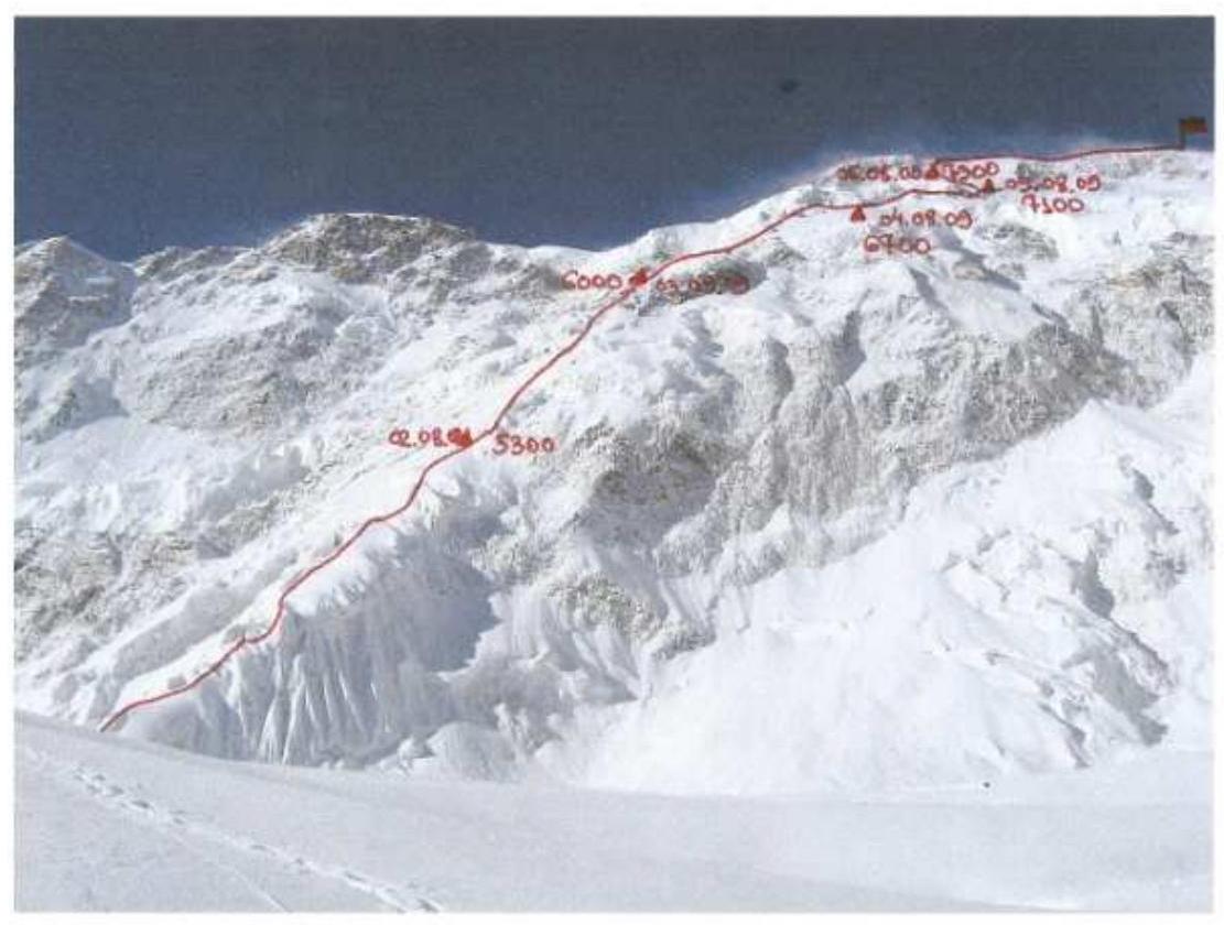
Photograph taken on August 1, 2009, from a bivouac on the Zvezdochka glacier at 4500 m.
Route of ascent to Peak Pobeda (Main), 7439 m, via the Northeast Counterfort, 6A category (V. Zhuravlev, 1990).
| Description of Section | Section No. | Category of Complexity | Length of Section, m | Steepness of Section, ° |
|---|---|---|---|---|
| Summit ridge | 29 | 2 | 400 | 3° |
| 28 | 5+ | 90 | 60° | |
| 27 | 4 | 170 | 45° | |
| 26 | 5+ | 40 | 50° | |
| 25 | 4 | 170 | 45° | |
| 24 | 5+ | 100 | 60° | |
| 23 | 5 | 80 | 50° | |
| 22 | 5 | 140 | 40° | |
| 21 | 4 | 180 | 50° | |
| Traverse right-up under overhanging ice wall to rock island | 20 | 5+ | 200 | 55° |
| 19 | 5+ | 180 | 55° | |
| 18 | 5 | 130 | 50° | |
| Traverse right-up under icefall wall | 17 | 5 | 250 | 45° |
| Traverse right under overhanging rock | 16 | 4 | 250 | 40° |
| 15 | 4 | 200 | 40° | |
| 14 | 5+ | 120 | 60° | |
| 13 | 5 | 140 | 55° | |
| 12 | 5+ | 100 | 50° | |
| 11 | 5+ | 15 | 70° | |
| 10 | 4 | 160 | 40° | |
| 9 | 5+ | 50 | 60° | |
| 8 | 6 | 50 | 80° | |
| 7 | 4+ | 180 | 35° | |
| 6 | 6 | 40 | 70° | |
| 5 | 6 | 15 | 80° | |
| 4 | 4 | 20 | 40° | |
| 3 | 6 | 6 | 90° | |
| 2 | 4 | 70 | 45° | |
| 1 | 6 | 8 | 80° | |
| 0 | 5+ | 150 | 45° |
View upwards towards the hanging glacier (height 6500 m).
R17. August 4, 2009, S. Kondrashkin in the photo.
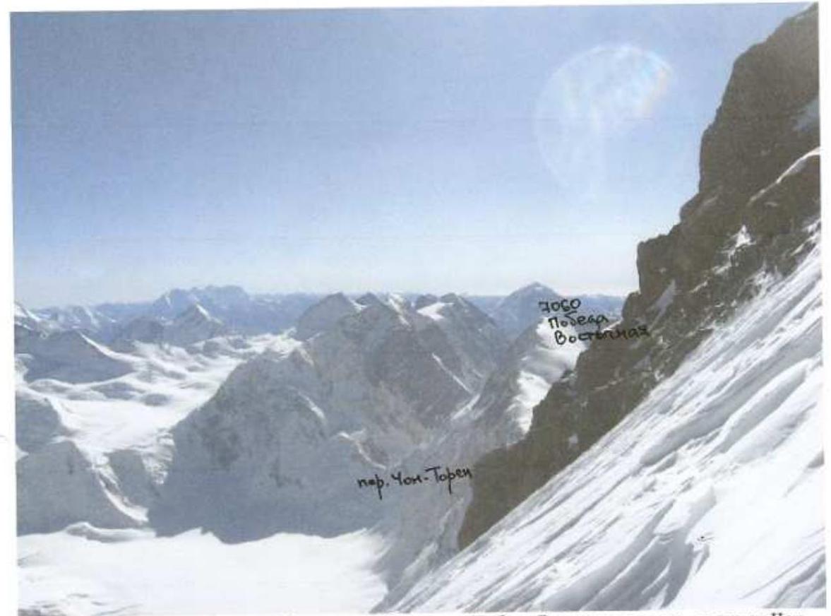
Photo from 7350 m towards the east. Right – ridge of Peak Pobeda East, further – Chon-Toren Pass and Peak Voennykh Topografov. August 6, 2009. R24.
R29. Viktor Koval after reaching the summit ridge (height 7430 m).
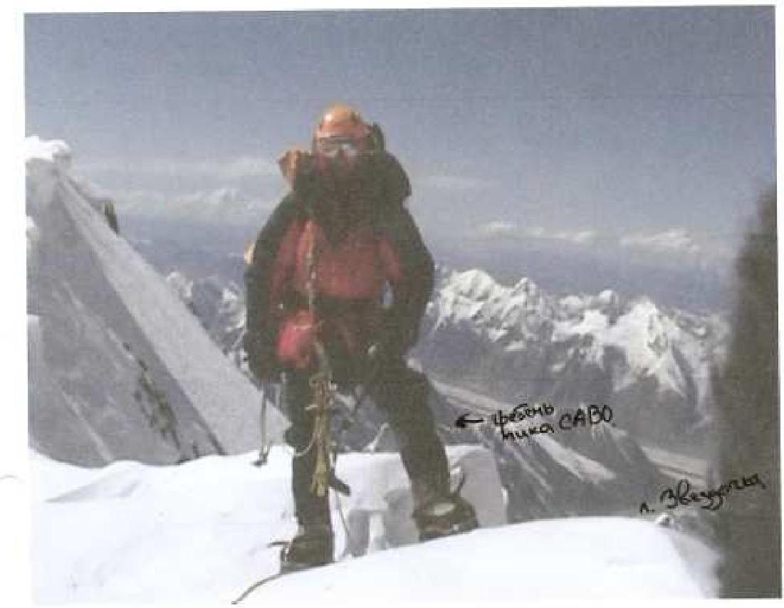
Photograph from a video camera, August 7, 2009.
Panorama towards China from the summit. August 7, 2009.