Pobeda Main 7439 m. Ascent via the NE buttress. Central Tian-Shan.
PASS
- Category of altitude ascents.
- Central Tian-Shan, Zvezdochka glacier.
- Peak Pobeda Main via NE buttress.
- First ascent, proposed category 5B.
- Elevation gain — 2639 m, route length — 3870 m.
Length of 6A category sections — 290 m. Average steepness of the route — 44°. Average steepness of 6A category sections: 50° (5192–5264); 70° (6026–6066); 50°, 65° (6144–6240); 60° (6608–6648); 75° (6816–6834).
- Pitons left on the route (not removed) — none. Insurance points organized on the route: rock — 12 ice — 109 snow anchors — 57
- Team's total climbing time 33 h 40 min and 4 days.
- Overnights: 1–2 in caves (lying down), 3 in a cave (semi-reclining).
- Team leader: Viktor Vasil'evich Zhuravlev, Master of Sports of the USSR
Team members:
- Igor Vladimirovich Benkin, Master of Sports of the USSR
- Andrey Evgen'evich Volkov, Candidate Master of Sports
- Vladimir Alekseevich Zhestkov, Candidate Master of Sports
- Vladimir Georgievich Zakharov, Candidate Master of Sports
- Vladimir Aleksandrovich Nefed'ev, Candidate Master of Sports
- Sergey Konstantinovich Penzov, Master of Sports of the USSR
- Coach: Sergey Petrovich Galkin — highest category coach, Master of Sports of the USSR
- Departure to the route: July 27, 1990. Summit — July 30, 1990. Return — July 31, 1990.
- Organization — Goskomsport RSFSR.
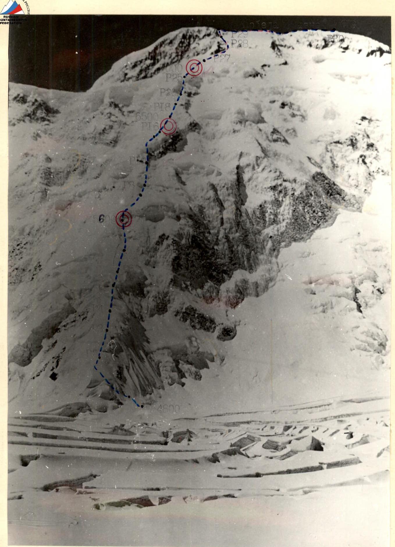
Photo 1. General photo of the route — route of the RSFSR team 1990. Taken on July 27, 1990 at 11:00. Lens "Industar-22", focal length 50 mm, shooting height 4700 m, distance to the route 3 km. Shooting point No. 1.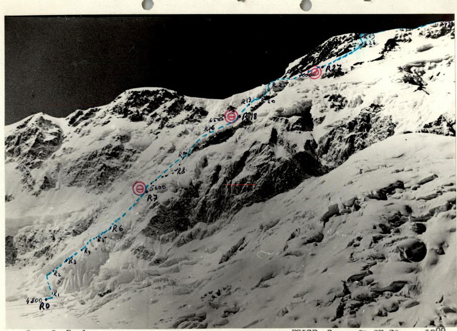
Photo 2. Profile of the route on the right — route of the RSFSR team. Taken on July 28, 1990 at 13:00. Lens "Industar-22", focal length 50 mm, shooting height 4600 m, distance to the route 6 km. Shooting point No. 2.
It is impossible to take a profile photo from the left due to the hanging glacier in the lower part and the wall of Peak Armenia.
TACTICAL ACTIONS OF THE TEAM
Route documentation was prepared on Issyk-Kul and certified by a representative of the KSP. According to the tactical plan, the departure to the route was scheduled for July 25 with a preliminary helicopter delivery of the team to the route. However, due to its absence on these days, the team was forced to approach the route on July 25 and 26 in bad weather during the first half of the day, having previously certified all documentation with the Championship judge and coordinating the departure to the route on July 27.
On July 27, 1990, at 8:00, the team departed in full composition from the cave under the route. The formation of rope teams was carried out according to readiness to depart. The rope teams worked mainly autonomously, and only on difficult sections were ropes used. Initially, everyone worked on the deep snow. During the day, a snack was organized in a safe niche for 1 hour. After restoring physical strength, the team continued working on the buttress. Choosing the optimal ascent option in good weather does not present difficulties: on the left, the buttress is bounded by a couloir in the lower part and then by the wall of the ridge from the Main summit to the East summit, and in the upper part at around 7000 m by a huge hanging glacier; on the right, the buttress is bounded in the lower part by a "cirque", and in the middle part by steep rock drops into the "cirque", and only at a height of 7000 m is it possible to deviate to the right onto Abalakov's route. Frequently changing leaders, the team maintained a high speed of ascent on the route. At 16:00, the team stopped for a bivouac to organize a cave in a snow overhang. For the day, 1305 m were covered, some of which required a colossal expenditure of physical and moral strength.
On July 28, 1990, having rested well, the team continued working at 6:20. The same principle of forming rope teams and changing leaders allowed for rapid progress on the route. During the day, a one-hour snack was organized in a safe niche to restore physical and moral strength. Understanding that good weather could deteriorate and due to the obvious danger, the team worked until 18:00 and organized a convenient bivouac in a deep crevasse on this day. 1350 m were covered, which was achieved with great difficulty.
On July 29, 1990, after resting, at 7:00, the team departed in full composition to continue on the route. Having passed the snowy and rocky part of the buttress, the team bypassed the hanging glacier on the right, which presented an objective danger, and organized a one-hour snack under a safe overhanging ice wall. Then, the team moved left-upwards into the upper part of the glacier. Passing through a steep wall to the right-upwards, the team broke free from the "captivity" of the glacier. Having reached around 7000 m, at 18:00, the team stopped for a bivouac, organizing a small cave in a depression on a firn slope. The cold and altitude had a significant impact, and the overnight stay was tolerable. On this day, 675 m were covered.
On July 30, 1990, at 9:00, the team continued working on the route. Severe cold, hurricane-force wind, and periodic fog significantly hindered progress towards the summit. Movement continued upwards and slightly to the left, and upon reaching the rocks, from below they appeared as a "W". Here, backpacks were left, as the team decided to descend via Abalakov's route. A bit more upwards to the left on steep rocks with snow and ice, and the team reached the summit ridge. Another half hour, and the team reached the summit of Peak Pobeda Main at 15:00! From the summit ridge, the team covered 540 m. After spending half an hour on the summit, at 15:30, the team began descending diagonally to the right towards the backpacks and then straight down, deviating onto Abalakov's route. Having descended to 6300 m, the team stopped for a bivouac on a safe platform, spending the night in a tent. Early in the morning, the team continued descending and met observers at 12:00. The team returned to the base camp in full composition at 17:00. By applying the tactic of an early departure, overnight stay in a cave, and having three hot meals on the route, the team ahead of the tactical plan by 1 day, having completed the entire route in good weather conditions but with very poor snow conditions. The first person worked with an attested rope. The gear taken corresponded to the route and was used. Special "combines" were used on the route for working on ice with an ice axe and on snow with an avalanche shovel, for digging caves. Good down gear and double boots in high-altitude balaclavas with high-altitude gloves that did not get wet in the snow allowed the team to avoid frostbite. There were no accidents or injuries on the route, nor any loss of gear. Communication with observers and the base was carried out via a "Kaktus" radio station and was regular and stable. Observations were conducted with a 12x binocular from the second day. A rescue team was located in the base camp with appropriate gear for the given route. Due to the rapid ascent, the team had reserve fuel, gas, and high-calorie food supplies that were brought back to the base. In case of an emergency, there was a plan to evacuate an injured person by helicopter to Przhevalsk.
Photo numbers reflecting moments of the ascent:
- Photo 5. Team work on the section R2–R3;
- Photo 6. Overnight stay during descent.
There are no other photos of the route due to the camera malfunctioning.
DESCRIPTION OF THE ROUTE BY SECTIONS
The route is very logical. Deviation left or right is not possible. To the right — steep drops, to the left — a rocky wall and icefall. The route begins to the right of a large crevasse with a steep snowy slope.
- Section R0–R1. Steep slope with deep snow up to 80 cm interrupted by a series of short crevasses. Movement on a full rope length with alternate belay. A lot of physical and emotional effort is expended.
- Section R1–R2. Quite long and gentle section. Simultaneous movement upwards to the right, bypassing steep ascents. Snow is denser, depth 40–50 cm.
- Section R2–R3. Quite steep ice wall with fresh snow on its irregularities. Ice is dense and requires organization of reliable belay using ropes.
- Section R3–R4. Simultaneous movement on a steep snowy slope, snow depth 30 cm.
- Section R4–R5. Long steep snowy slope with loose snow more than 1 m deep. Each step is formed in stages, multiple times, before the snow is loaded. Movement is alternate with the use of ropes to the right-upwards, bypassing an overhanging wall. An enormous amount of physical and moral strength is expended. Movement forward is at the limit of human capabilities.
- Section R5–R6. Quite steep ice wall with uneven relief, covered with fresh snow. Alternate movement.
- Section R6–R7. Long, quite gentle snowy slope. Passed with alternate and simultaneous movement. At the end of the section, a cave was organized under an overhang.
- Section R7–R8. Steep, long ice-snow-firn slope, where these three states often alternate. Movement on dangerous sections using ropes.
- Section R8–R9. Steep rocky walls, interspersed with "ram's foreheads", covered with snow, present great difficulty. Movement using ropes.
- Section R9–R10. Rope length on a steep snowy slope. Alternate movement.
- Section R10–R11. Very steep ice wall with hard ice. Special steel ice screws with long handles go in no more than 10 cm. Movement on ice axes using ropes.
- Section R11–R12. Steep snow-firn slope with a passage to the right of a large crevasse. Alternate movement.
- Section R12–R13. Quite steep rocky walls under ice. Movement from right to left using ropes requires very good technical preparation, where the factor of altitude also comes into play. Ice screws are screwed in up to 7 cm.
- Section R13–R14. Very steep ice wall with snow drifts on ledges and shelves. Passing it takes a lot of moral strength and requires good ice climbing skills. Ropes are used.
- Section R14–R15. Quite steep snowy slope is passed with alternate belay.
- Section R15–R16. Steep ice wall is passed using ropes. Ice screws go in very poorly. Ice is over-frozen, flakes off in lenses. Using ice axes requires skills of working on over-frozen ice.
- Section R16–R17. Long, quite steep ice-snow slope; alternate belay.
- Section R17–R18. Long, quite steep snow-firn slope. Deep snow — up to one meter. Requires clear organization of step formation. In places, movement is on "all fours" on a snow crust. Movement is alternate using ropes. The section ends with a deep crevasse where a cave is organized. Requires significant physical expenditure.
- Section R18–R19. Quite long, steep ice-snow section, where ice is unexpectedly interrupted by very deep snow and vice versa.
- Section R19–R20. Steep ice wall with very hard ice. Ice screws go in no more than 7 cm. Very high demands on technical preparation. Movement using ropes.
- Section R20–R21. Movement to the right upwards on steep rocks, in places with flow ice. Ropes are used.
- Section R20–R21. Movement in the direction of the ice wall, under it a snack, and then up the snowy slope to the left.
- Section R22–R23. Steep ice slope leads into the fractures of the hanging glacier to the right. Alternate movement.
- Section R23–R24. Simultaneous movement in the fractures on snow under the base of the ice wall to the right.
- Section R24–R25. Very steep ice wall with over-frozen ice. Requires skilled use of ice screws and ice axes. Ropes are used. High demands on physical and ice climbing preparation. Altitude and cold are significant hindrances.
- Section R25–R26. Gentle snowy slope. Simultaneous movement.
- Section R26–R27. Movement on a quite steep snow-ice-firn slope in the direction of the middle of the summit ridge using alternate belay. At the end of the section, a small cave is organized in a firn slope with great physical effort. A tent covered the entrance. Very cold.
- Section R27–R28. Quite steep ice-snow slope, long, in the direction of the left part of the rocky "W", and passage among rocks using alternate belay. Here, on the rocks, backpacks were left on belay.
- Section R28–R29. Steep rocky slope with ice requires significant physical expenditure. Alternate movement, ropes are used, and the summit ridge is reached!
- Section R29–R30. Almost horizontal rocky ridge with small snow drifts. Movement from the Chinese side to the right along the way to the summit. The route ends with simultaneous movement to the control tour. Summit! The note of Khrshchatyi's winter expedition 1990 was found. Our ascent was the first to Pobeda Main in the summer season of 1990.
Descent from the summit via V. Abalakov's route took 11 hours with an overnight stay in a tent at 6300 m.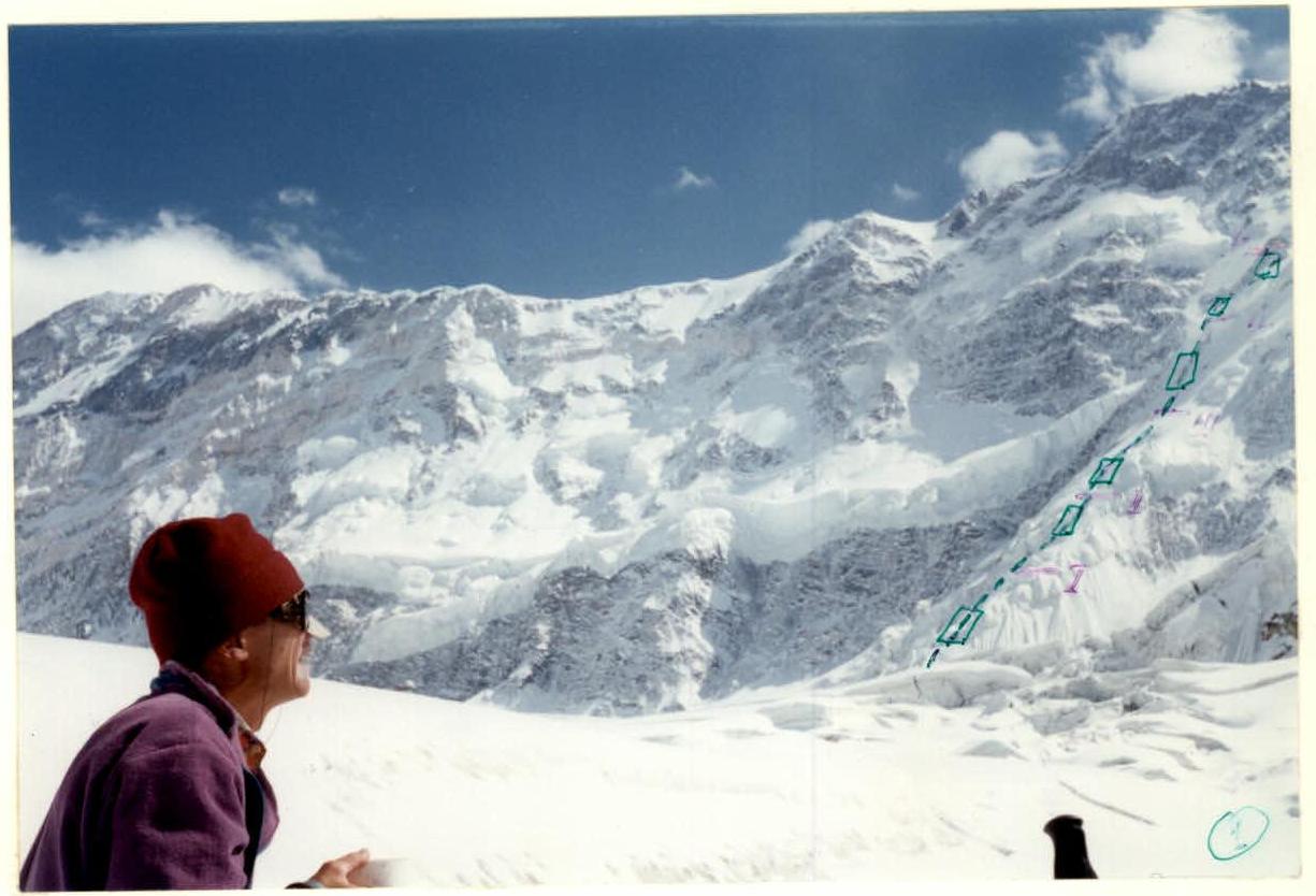
View of the lower section of the route from the overnight stay on the Zvezdochka glacier.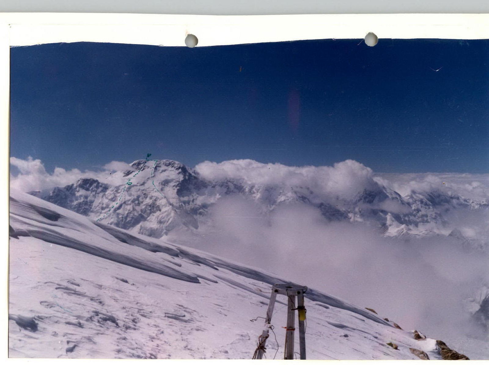
View of Peak Pobeda from the summit of Peak Khan-Tengri on August 2, 1992. By F. Strelkov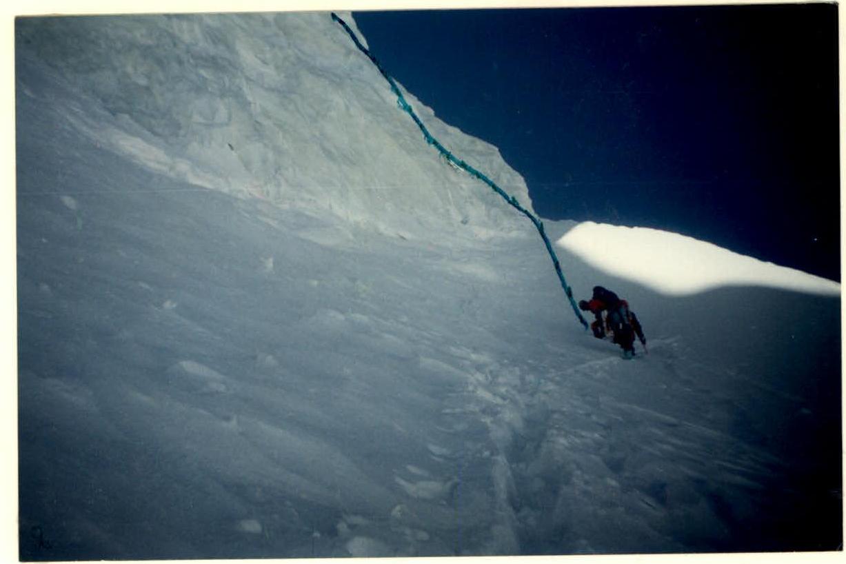
Strelkov and Penzov on the approach to the ice wall, 3rd section.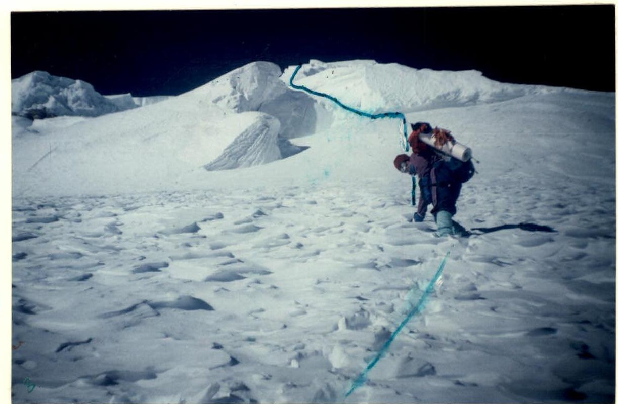
On the ice-firn slope before the wall. 4th section, August 19, 1987.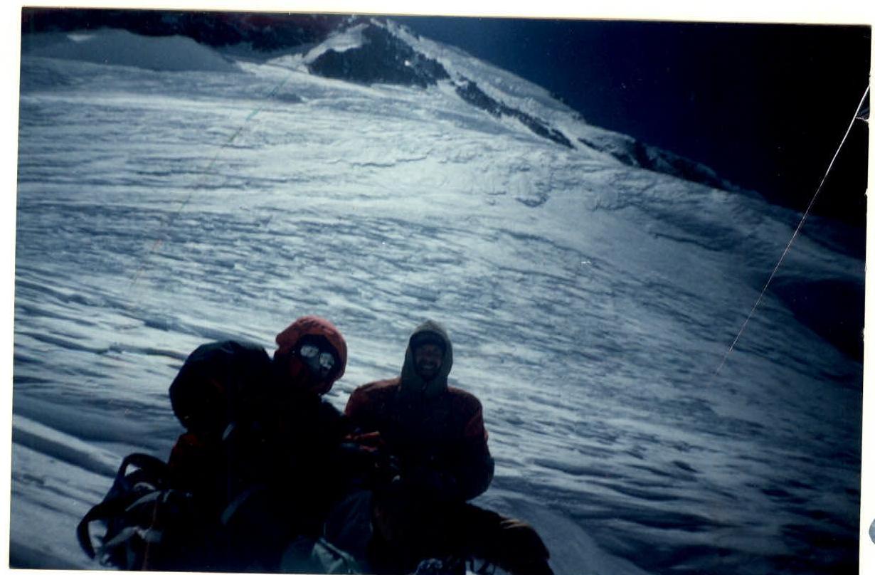
Before the upper rocky section, waiting for F. M. Ishutin's rope team.