XXXV USSR Alpine Championship 1984. High-altitude Class
REPORT on the ascent of Peak Pobeda (7439 m) via the north face of the eastern peak (first ascent) by the team of the USSR Armed Forces
Team leader: V.N. Khrishtatyy, coach: E.T. Ilyinsky, Honored Master of Sports, Honored Coach of the USSR
Addresses and phone numbers:
-
Team leader - Valery Nikolayevich Khrishtatyy
- Address: 480021, Alma-Ata, Kurganazy St., 15, apt. 8
- Phone: 61-27-25, p. 63-39-62
Team coach - Ervand Tikhonovich Ilyinsky
- Address: 480012, Alma-Ata, Seyfullin St., 537, apt. 4
- Phone: 67-79-52
-
Organization - 480051, Alma-Ata, 51, 12 SCA SAVO, tel. 681793, Olenin I.L.
-
Heights were determined using topographic maps, altimeter, and data from military topographers working in the area during the team's route.
PASSPORT
-
Class - high-altitude
-
Central Tien Shan, Kokshaal-Tau ridge, "Zvezdochka" glacier
-
Peak Pobeda via the north face of the eastern peak
-
Proposed - 6B category of difficulty, first ascent
-
Height difference of the wall section - 2020 m
Length of the wall section - 2600 m, length of sections with 5-6 category of difficulty - 610 m, including 140 m of 6th category, average steepness of the wall section - 58°
-
Number of pitons used:
rock - 195, bolt - 3, ice - 70, chocks - 28
-
Time taken to reach the summit - 76 hours, number of days - 13
-
Overnight stops: R1-R7 - carved into ice and partially artificially constructed, R6, R8-R9 - snow platform
-
Team leader: Valery Nikolayevich Khrishtatyy - Master of Sports of International Class (MSMK)
Team members:
- Kazbek Shakimovich Valiyev - MSMK
- Nikolai Fedorovich Vinokurov - Candidate for Master of Sports (CMS)
- Grigory Yevgenyevich Lunyakov - Master of Sports (MS)
- Yuri Mikhailovich Moiseev - MS
- Vadim Anatolyevich Smirnov - MSMK
- Vladimir Ivanovich Suviga - MS
- Viktor Vladimirovich Shkarban - MS
-
Coach: Ervand Tikhonovich Ilyinsky, Honored Master of Sports, Honored Coach of the USSR
-
Route reconnaissance: August 12, 13, 14, 1984
Departure for the route: August 17, 1984. Summit: August 24, 1984. Return: August 26, 1984.
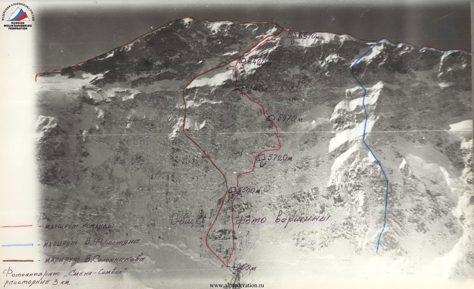
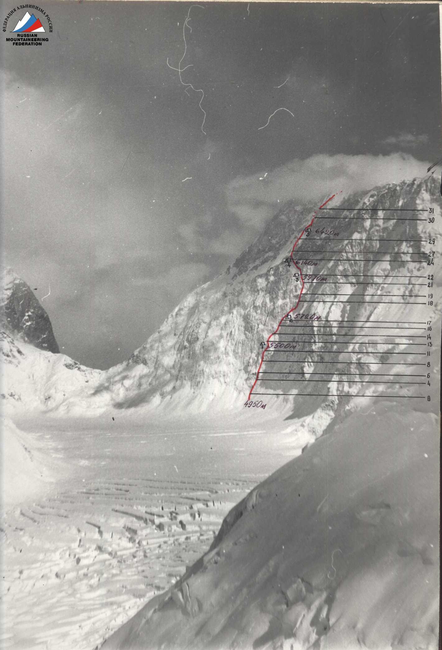
Profile of the wall on the right
15 hours. Distance 3.8 km.
Camera "Smena-Symbol"
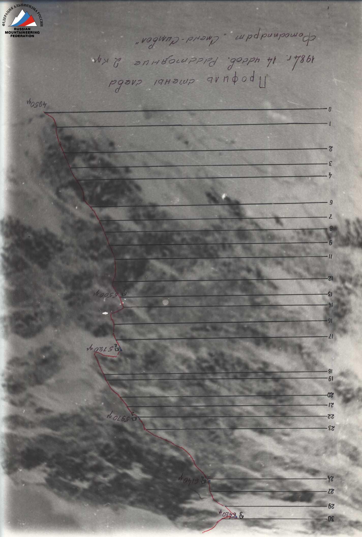
Profile of the wall on the left
1984. 14 hours. Distance 2 km.
Camera "Smena-Symbol"
Profile of the wall section. Scale 1:10 000

Map of the climbing area. Scale 1:100 000
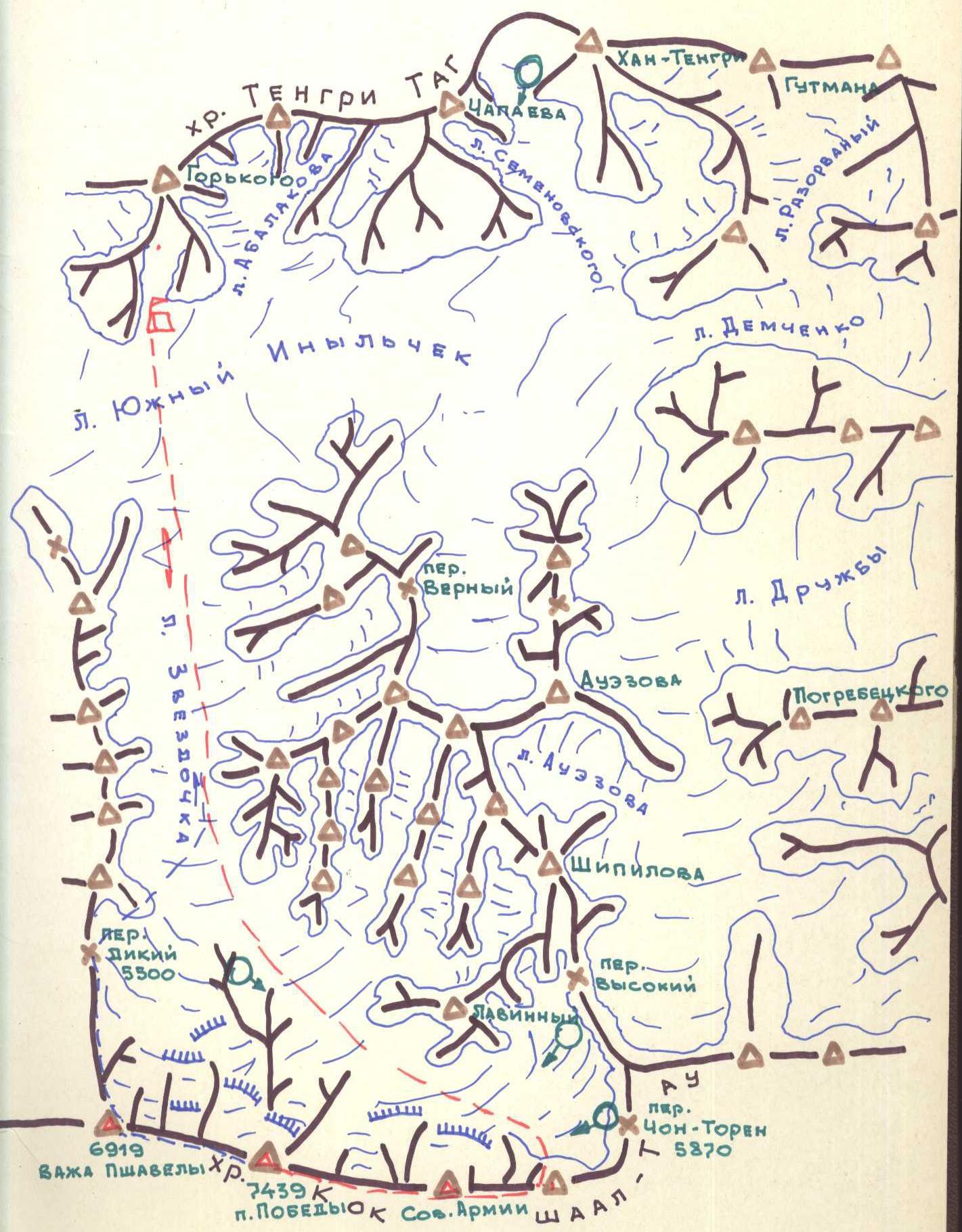
Photopanorama of the area

Brief overview of the climbing area
Peak Pobeda (7439 m) is the northernmost seven-thousander on the planet. The peak and the entire massif are located in the upper reaches of the "Zvezdochka" glacier (a left tributary of the "South Inylchek" glacier). The massif is situated in the Kokshaal-Tau ridge.
The main peak is a combined ridge about 1.5 km long. To the west, the ridge descends in three rather steep steps and then continues to a new rise (Peak Vazha Pshavela, 6918 m).
To the east, the massif descends to Eastern Pobeda (7003 m), forming the eastern shoulder of Peak Pobeda with a small rise towards the main peak (Peak Soviet Armenia). The eastern shoulder then drops steeply to the Chon-Teren pass (5470 m).
The length of the Peak Pobeda massif from the eastern peak to the western peak (Peak Vazha Pshavela) is about 15 km.
History of the peak's conquest
The first ascent of Peak Pobeda (7439 m) was made by a team from Moscow's "Spartak" sports club led by Vitaly Mikhailovich Abalakov via the north ridge of the main peak in 1956.
There are reports that in 1938, a team led by Gutman made an ascent of Peak Pobeda from the north and named it Peak "20 Years of VLKSM" to commemorate the anniversary of the Komsomol.
In 1958, a team led by I. Yerokhin made an ascent of the main peak from the Chon-Teren pass.
In 1961, Georgian climbers led by Medzmariashvili ascended Peak Pobeda via the western peak (Peak Vazha Pshavela) from the Diky pass.
In 1967, a team led by V. Ryabukhin completed the first full traverse of Peak Pobeda from the Diky pass to the Chon-Teren pass.
In 1970, a team led by V. Ivanov traversed the peaks of Nerer (6742 m) and Pobeda.
In 1982, a new, unconventional route was laid. A team from the Sports Club of the Army of the SAVO led by V. Smirnov ascended the main peak via the north face.
Preliminary familiarization and photography of Peak Pobeda from the north took place in 1974 during a helicopter flyover to the peak. The Pobeda massif was photographed from the north, and possible ascent routes were identified. One of these routes was taken by the team led by V. Smirnov in 1982 to the main peak.
At that time, a closer "acquaintance" with the peak and the area took place. The team experienced the harsh weather conditions of the area, which made it particularly challenging.
We were fortunate that four participants in the 1982 ascent of Peak Pobeda were part of the current team. Before starting the route, the team drew on their experience of high-altitude ascents of the highest category of difficulty to peaks such as:
- Peak Kommunizma from the Belyaev glacier (Kuzmin and Valiyev's route);
- Peak Rossiya (Ilyinsky's route);
- Peak Akhmad-Donis (Smirnov's route);
- Peak Khan-Tengri (Kuzmin's route);
- Traverse of Peaks Khan-Tengri - Mramornaya Stena;
- Peak Pobeda from the north (Smirnov's route).
At the first stage of preparation, particular attention was paid to:
- Further development of overall and special physical fitness;
- Improvement of tactical and technical techniques for overcoming complex rock and ice terrain.
At the second stage, starting from January, the main focus was on preparing for the specific ascent of Peak Pobeda. Training took place in a gym, in the Medeo area, and in the Tuyuk-Su alpine camp. Climbs were made with groups of novice and rated climbers. Each championship participant made between 10 and 20 ascents during this stage.
Just before departing for the area, most team members undertook acclimatization and training ascents to Peak Lenin and Peak E. Korzhenevskaya as part of their special technical training.
| Date | Activity/Weather | Height/Progress |
|---|---|---|
| August 12, 1984 | Reconnaissance | 4950–5400 m |
| August 13, 1984 | Reconnaissance | 5400–5500 m |
| August 14, 1984 | Reconnaissance | 5500–5600 m |
| August 15, 1984 | Heavy snowfall | |
| August 16, 1984 | Heavy snowfall | 5600 + 70 m |
| August 17, 1984 | Ascent | 5600–5720 + 110 m |
| August 18, 1984 | Ascent | 5720–5970 + 80 m |
| August 19, 1984 | Ascent | 5970–6140 + 160 m |
| August 20, 1984 | Ascent | 6140–6420 + 180 m |
| August 21, 1984 | Ascent | 6420–6970 m |
| August 22, 1984 | Ascent | 6970–7000 m |
| August 23, 1984 | Ascent | 7000–7430 + 9 m |
| August 24, 1984 | Hurricane-force wind, fog in the evening | |
| August 25, 1984 | Descent |
Tactical actions of the team
The tactical plan developed before the ascent fully corresponded to the time taken by the team to complete it.
During the ascent, the team used a tactic of processing the route from intermediate camps. The team was able to pass the sections processed the previous evening up to a suitable overnight stop. Then, a rope team would proceed to process further, while the rest prepared the campsite.
Therefore, we abandoned the planned paired overnight stops.
In the middle section of the route, we had planned to ascend the wall vertically, but the smooth rock terrain with ice required significant bolting work. So, we deviated to the right and followed the wall where the rock relief was more pronounced, taking advantage of the fact that the icefall's work line was to the right of our initial plan.
In the upper third of the route, upon receiving worrying news about a Ukrainian team, we decided to simplify the route by forcing our way to the ridge and, instead of traversing the "triangle" in the center, we turned to its lower left part and then bypassed the "triangle" on the left side.
When processing the lower part of the wall - the "mirror", we planned to process the section. This was due to the lack of suitable overnight stops on the "mirror".
There were no fixed rope teams. The leaders and the rope teams changed throughout the route.
Preliminary processing was carried out on the following sections:
- R0-R5 (Valiyev - Khrishtatyy)
- R5-R8 (Khrishtatyy - Valiyev)
- R8-R10 (Shkarban - Moiseev)
- R10-R11 (Smirnov - Vinokurov)
- R11-R13 (Moiseev - Shkarban)
- R13-R15 (Khrishtatyy - Valiyev)
Processing from intermediate camps with the establishment of fixed ropes:
- Camp 1, section R15-R16 (Smirnov - Vinokurov)
- Camp 2, section R17-R18 (Shkarban - Valiyev - Suviga)
- Section R18-R19 (Valiyev - Shkarban - Suviga)
- Camp 3, section R22-R23 (Smirnov - Suviga)
- Camp 4, sections R24-R26 (Valiyev - Vinokurov)
- Section R26-R27 (Vinokurov - Smirnov)
- Camp 5, section R29-R30 (Shkarban - Valiyev - Moiseev)
- Section R30-R31 (Moiseev - Valiyev)
The first to work on new sections during camp changes were:
- Section R16-R17 (Smirnov-Lunyakov)
- Sections R19-R21 (Khrishtatyy-Suviga)
- Section R21-R22 (Khrishtatyy-Smirnov)
- Section R23-R24 (Lunyakov-Vinokurov)
- Sections R27-R29 (Smirnov-Suviga)
- Section R31-R32 (Lunyakov-Vinokurov).
NOTE: The first person in the rope team is the leader. The team started moving at 9:00-10:00 and finished at 17:00-18:00 to prepare the overnight stop. At this time, the rope team would proceed to process further.
The team maintained radio communication between the wall, observers on the "Zvezdochka" glacier, the base camp on the "South Inylchek" glacier, and the Control Points (KSP) in Prjevalsk and Alma-Ata. Observers under the wall had a 6x binocular and a 60x telescope.
At the base camp, a rescue team was constantly present during the team's ascent.
The senior coach continuously monitored the team's progress and adjusted their actions via radio communication.
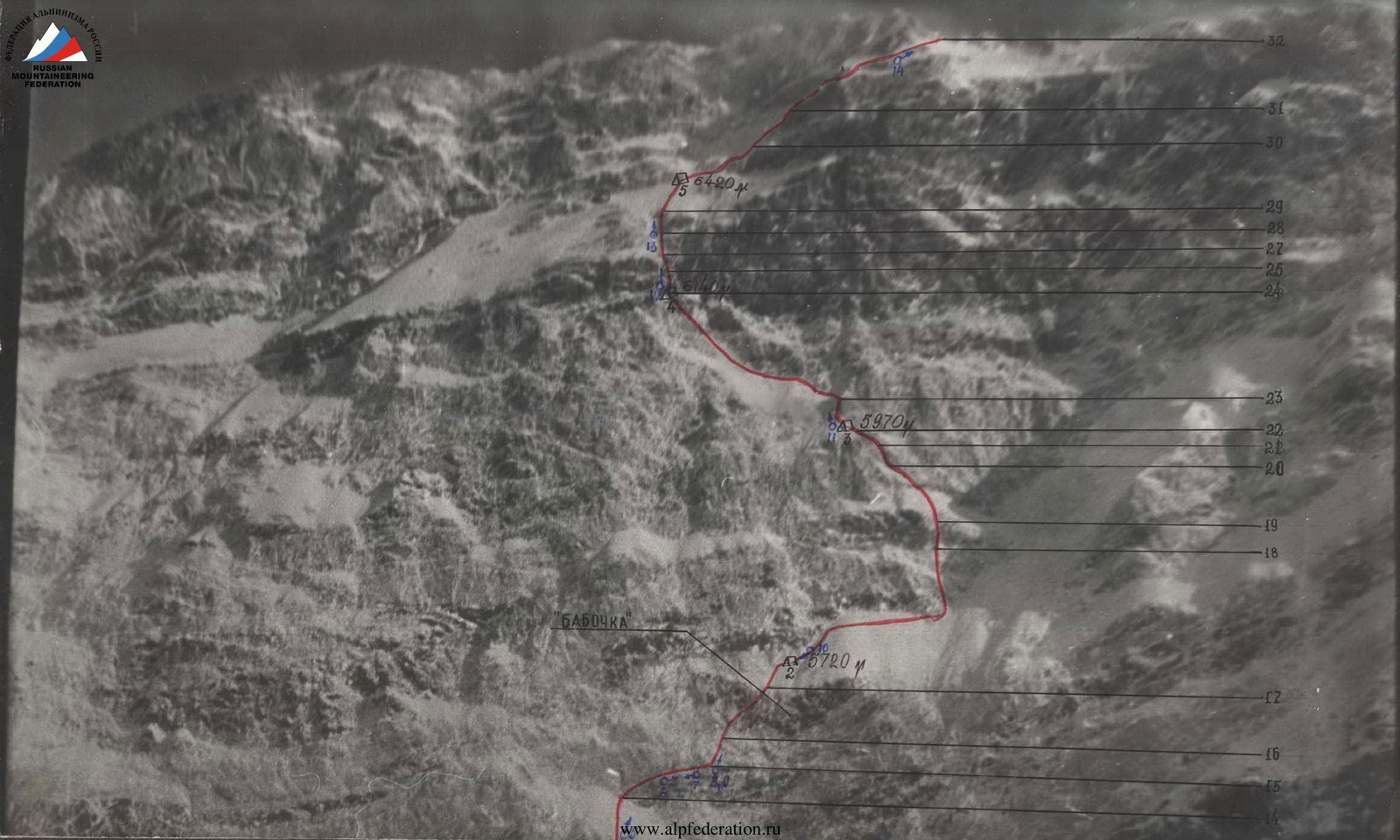
Description of the route by sections
August 12, 1984. At 6:00, the team began processing the lower part of the wall. After traversing 100 m of a snow slope (35-40°), they reached a bergschrund. The height was approximately 5000 m. For two weeks, the area had enjoyed fine, hot weather. Teams working on the wall (from Leningrad and Ukraine) reported working without gloves during the day. Now it was cooler, but still quite warm at 6:00 for this area. Fog was visible above, approximately at a height of 6000-6500 m.
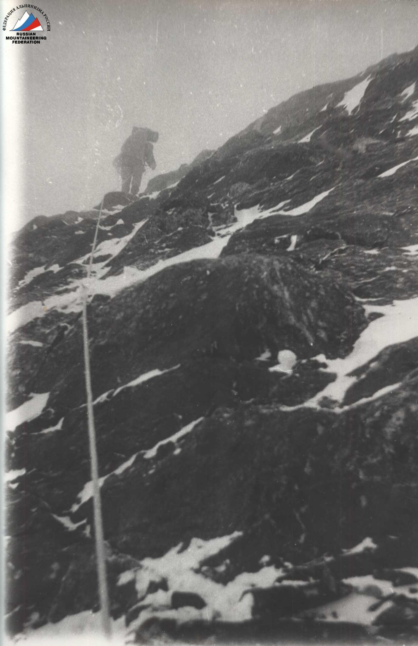
The bergschrund was crossed via a snow bridge. Immediately beyond it, a steep ice slope (section R0-R1) was encountered, followed by steep, smooth rock faces (sections R1-R2 and R3-R4) that were icy and snow-covered. Valiyev navigated these sections using an ice axe and ice hammer (section R2-R3 (Photo 1)).
A steep rock wall was challenging, with frequent hammering of pitons.
-
Section R4-R6 (Photo 2): Started via an internal corner, which was steep, with smooth rocks covered in ice. The internal corner led to a slightly less steep wall. To the right, the wall became even less steep, leading to an icy ridge.
-
Section R7-R9: Began via a gully. It was snowy and transitioned into a wall, then back into a snowy, icy gully. The weather was poor, with snowfall. Occasional dry avalanches descended from above. Clothing became soaked. At 20:00, the Shkarban-Moiseev rope team finished processing and began descending.
August 13, 1984. The Smirnov-Vinokurov rope team started moving along the fixed ropes at 7:00. Upon reaching the end of the ropes, they continued processing the wall.
-
Section R10-R11: The gully led to an almost vertical wall of marbleized limestone, making climbing very challenging. The wall (second white belt) was traversed via a vertical, wide, blunt crack using artificial aids (ITO). The weather was poor, with snowfall and fog. Clothing quickly became soaked.
-
Section R11-R12: A traverse to the left and upwards along a narrow, snowy ledge on a steep wall. By evening, the weather began to improve.
-
Section R12-R13: A series of walls with rib-like features. It was snowy, with frequent ice formations. At the top of the section, a possible overnight stop was identified on the left. By evening, it had cooled down significantly, with ropes becoming ice-encrusted and wet clothing covered in a layer of ice. Work on the wall ceased at 20:00.
August 14, 1984. The final day of processing. The morning was unusually warm, with fog and snowfall, and visibility was limited to 300 m. The previous day, they had processed up to a height of approximately 5500 m. At 6:00, the Khrishtatyy-Valiyev rope team ascended via the fixed ropes.
-
Section R13-R14 - a snowy-icy slope was traversed upwards and to the right, marking the beginning of the middle section of the wall, composed of marbleized limestone.
-
Section R14-R15 (Photo 5): A long traverse along a narrow ledge. As they traversed the ledge, dust avalanches began to fall continuously. Due to low productivity, processing was halted. At 17:00, the rope team began descending.
August 15 and 16, 1984. Bad weather, heavy snowfall. Due to increased avalanche danger, work on the wall was suspended. The team waited out the bad weather on the glacier at the observers' camp. On the evening of August 16, 1984, the weather improved, and it was observed that the Ukrainian team was finishing their route on the wall by ascending to the ridge. The entire wall was swept by strong winds.
August 17, 1984. The weather was good. It was cold and windy. The team departed in full at 8:00. After traversing 15 rope lengths, the Smirnov-Vinokurov rope team proceeded to process the further route, while the rest descended 40 m to the left and 20 m down from the end of section R12-R13 to set up an overnight stop. Upon clearing the area, they discovered bolted pitons, indicating a previous overnight stop by V. Solonnikov's team.
-
Section R15-R16 (Photos 8, 9): A steep, overhanging wall in the lower part. Climbing was very challenging; Smirnov used ITO three times during this section.
-
The wall then became less steep (section R16-R17, Photo 9) and led to a snowy-icy slope. At 20:00, the rope team returned from processing, having completed sections R15-R16 and R16-R17.
-
Section R17-R18: A snowy-icy slope with frequent embedded rock debris. The ice was relatively soft and presented no significant difficulties.
-
The overnight stop (Photo 10) was carved into the ice under the protection of the wall. By evening, the weather began to deteriorate, with fog rolling in. The Valiyev-Shkarban-Suviga rope team returned to the overnight stop after 20:00, having processed 7 rope lengths.
August 19, 1984. The morning was overcast, but relatively warm. The team ascended via the fixed ropes.
-
Section R20-R21: A rocky ledge covered in ice led to the entrance of a gully.
-
Section R21-R22 (Photo 11): The gully ascended, with a significant amount of ice. At the top of the gully, there was a kink, where the third overnight stop was set up in a sitting position. By evening, the weather cleared, and it became cold. From the overnight stop, they processed another 4 rope lengths. The height was approximately 6000 m. At 20:00, they received news that there had been no contact with the Ukrainian team for two days. Observers with a telescope had not seen them or their tracks. Everyone was very concerned. After consulting, they decided to simplify the route by forcing their way to the ridge. Assistance might be required.
August 20, 1984. The weather was good, and it was cold. A strong gusty wind blew.
- Section R22-R23: From the overnight stop, they ascended directly upwards. After the wall, they reached a snowy-icy slope (section R23-R24). At the end of the slope, upon reaching a kink under the wall, they encountered some straightforward rocks. At the kink, they set up an overnight stop. The height was approximately 6200 m. By midday, a very strong wind had picked up, blowing away clouds and reducing visibility. They received a weather forecast for the coming days, predicting a cyclone. That day, they processed 6 rope lengths ahead.
August 21, 1984. The morning was overcast, with fog, snowfall, and strong gusty winds. Visibility was limited.
-
Sections R24-R27 (Photo 12): From the overnight stop, they ascended a steep wall upwards, then to the right, and again directly upwards. Climbing was challenging, with Valiyev using ITO once.
-
Section R27-R28: After the wall, a snowy-icy slope was traversed directly upwards under another wall.
-
Section R28-R29: Two rope lengths of steep rock faces resembling "ram's foreheads" of medium difficulty were traversed directly upwards. Then, a relatively gentle snowy-icy slope was encountered, where small platforms were carved out for tents. By evening, the weather cleared. The Shkarban-Valiyev-Moiseev rope team processed further. By 20:00, having fixed 7 rope lengths, the rope team descended to the overnight stop.
August 22, 1984. The morning was clear and very cold.
- Sections R30-R32 (Photo 4) presented no significant technical difficulties. In the afternoon, a strong wind picked up, accompanied by fog. When the entire team reached the ridge (at 18:00), the wind became hurricane-force. They descended 100-150 m to the south and set up tents in a depression.
August 23, 1984. The wind was strong, with frequent low visibility. They ascended to the ridge. There was almost no loose snow; they only had to tramp down the snow in a few places. By 12:00, the wind had almost died down. Old tracks were visible along the ridge. By evening, they reached Peak Soviet Armenia. The wind picked up again. They set up an overnight stop under the dome of the main peak of Pobeda. At 20:00, they established direct radio contact with the base camp for the first time.
August 24, 1984. The morning brought very strong winds, which completely exposed the ice. It was decided to abandon the original plan due to the strong wind and abundance of ice and instead follow the Abalakov route via the north ridge to the main peak of Pobeda. Around 17:00, despite continuous hurricane-force winds, they reached the summit dome. Not far from the summit cairn, they set up one tent.
The Valiyev-Vinokurov-Khrishtatyy rope team went to explore the eastern part of the summit dome. As the dome was large and the search might take a long time, they took a tent, primus stove, and supplies with them. The wind remained strong, and there was dense cloud cover. After 40-50 minutes of moving, they stumbled upon Tolstoy's burial site. About an hour later, on the eastern edge of the dome, in a kink, Khrishtatyy came across a frozen corpse. At 20:00, they reported their findings via radio and headed back to the first tent. The wind intensified, and it began to get dark. They decided to set up a tent and spend the night 40-50 m before reaching Tolstoy's burial site.
Due to bad weather, they couldn't level the ground properly, resulting in a semi-reclining overnight stop.
August 25, 1984. Around 8:00 in the morning, the Shkarban-Smirnov rope team joined them from the first tent. The weather was good, but a strong wind was blowing, and there was drifting snow. They visited the site where the Ukrainian climber lay.
They didn't find a note in the cairn the previous day. Their repeated search yielded nothing. They left their own note and, at 12:30, began their descent towards Peak Vazha Pshavela, following the first rope team.
During the day:
- The weather improved by midday.
- The wind almost ceased.
- Only by evening did sharp gusts resume.
The team spent the night on the Diky pass.
Equipment table
 |  |  |
|---|
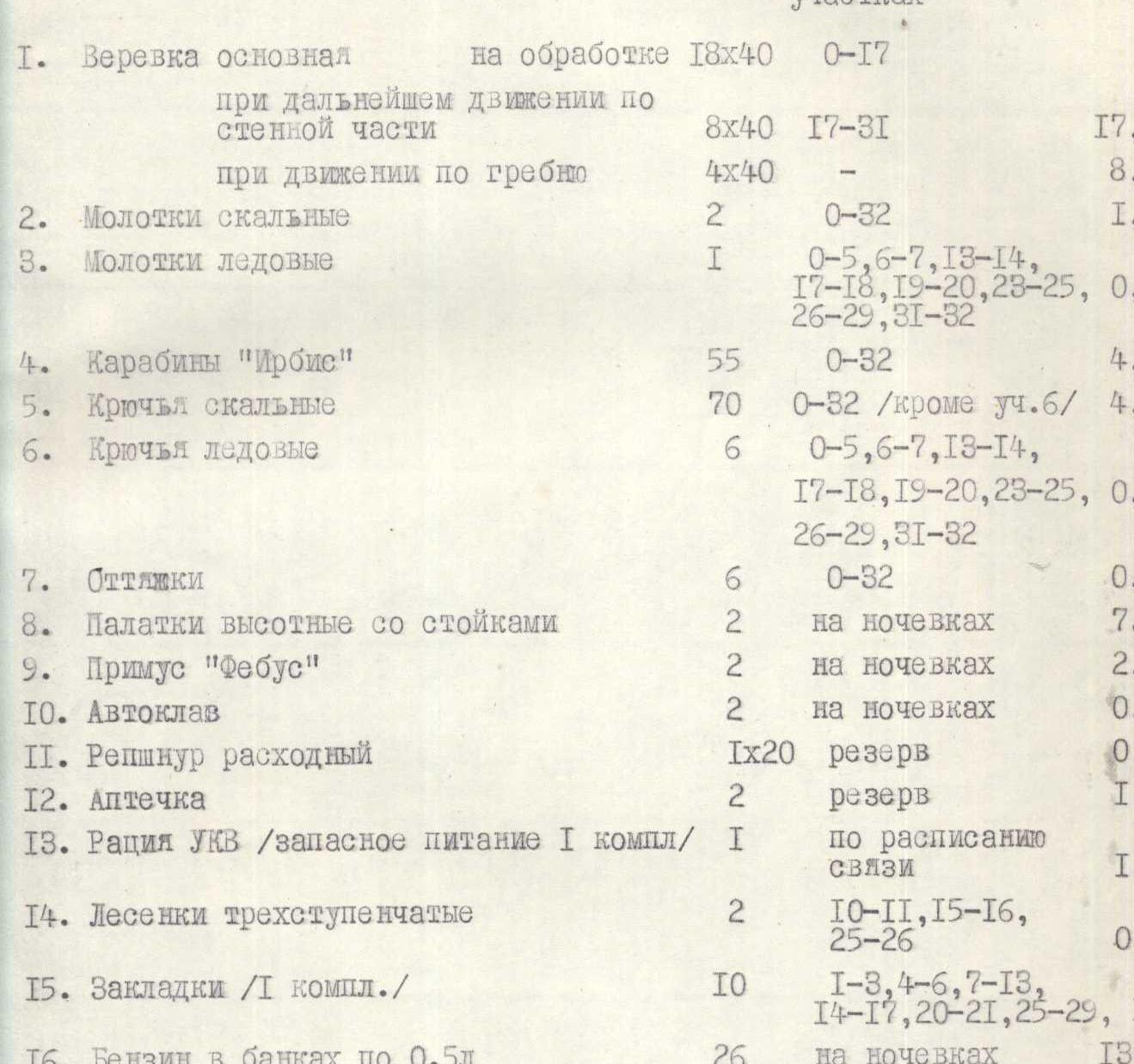
The weight of food supplies when departing for the route was 40 kg. The total weight of backpacks when departing was about 15 kg.
| № п/п | Name | Quantity | Application on sections | Weight |
|---|---|---|---|---|
| 1. | Main rope for processing | 18×40 | R0-R17 | |
| during further movement along the wall | 8×40 | R17-R31 | 17.6 | |
| during movement along the ridge | 4×40 | 8.8 | ||
| 2. | Rock hammers | 2 | R0-R32 | 1.2 |
| 3. | Ice hammers | 1 | R0-R5, R6-R7, R13-R14, R17-R18, R19-R20, R23-R25, R26-R29, R31-R32 | 0.8 |
| 4. | "Irbis" carabiners | 55 | R0-R32 | 4.1 |
| 5. | Rock pitons | 70 | R0-R32 (except R6) | 4.0 |
| 6. | Ice pitons | 6 | R0-R5, R6-R7, R13-R14, R17-R18, R19-R20, R23-R25, R26-R29, R31-R32 | 0.6 |
| 7. | Quickdraws | 6 | R0-R32 | 0.5 |
| 8. | High-altitude tents with poles | 2 | at overnight stops | 7.0 |
| 9. | "Febus" primus stove | 2 | at overnight stops | 2.0 |
| 10. | Autoclave | 2 | at overnight stops | 0.8 |
| 11. | Spare reepschnur | 1×20 | reserve | 0.5 |
| 12. | First-aid kit | 2 | reserve | 1.3 |
| 13. | VHF radio (with spare battery pack) | 1 | according to communication schedule | 1.0 |
| 14. | Three-step ladders | 2 | R10-R11, R15-R16, R25-R26 | 0.5 |
| 15. | Chocks (1 set) | 10 | R1-R3, R4-R6, R7-R13, R14-R17, R20-R21, R25-R29 | 1.1 |
| 16. | Gasoline in 0.5-liter cans | 26 | at overnight stops | 13.0 |
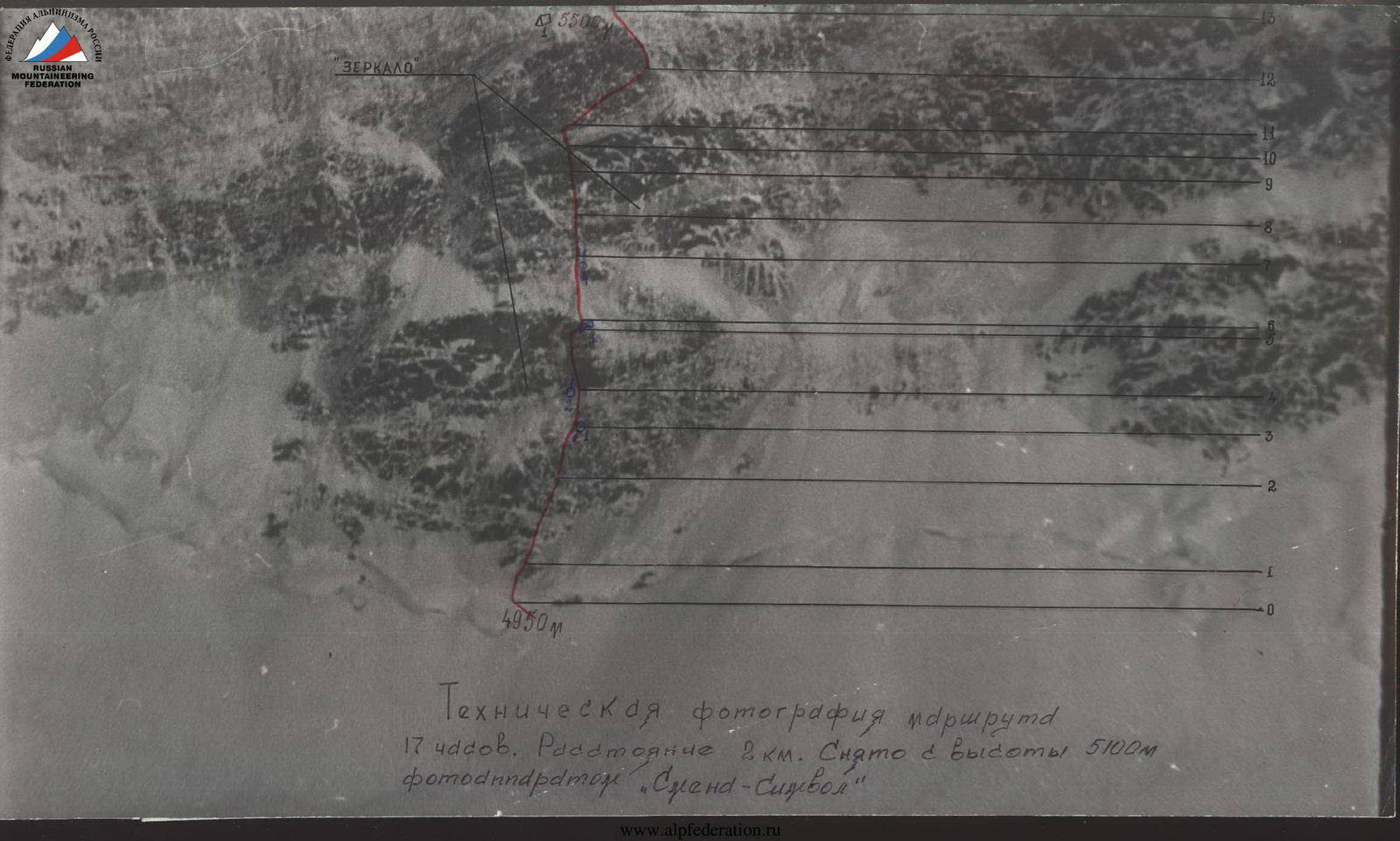
Technical photography of the route, 17 hours. Distance 2 km. Taken from a height of 5100 m with a "Smena-Symbol" camera
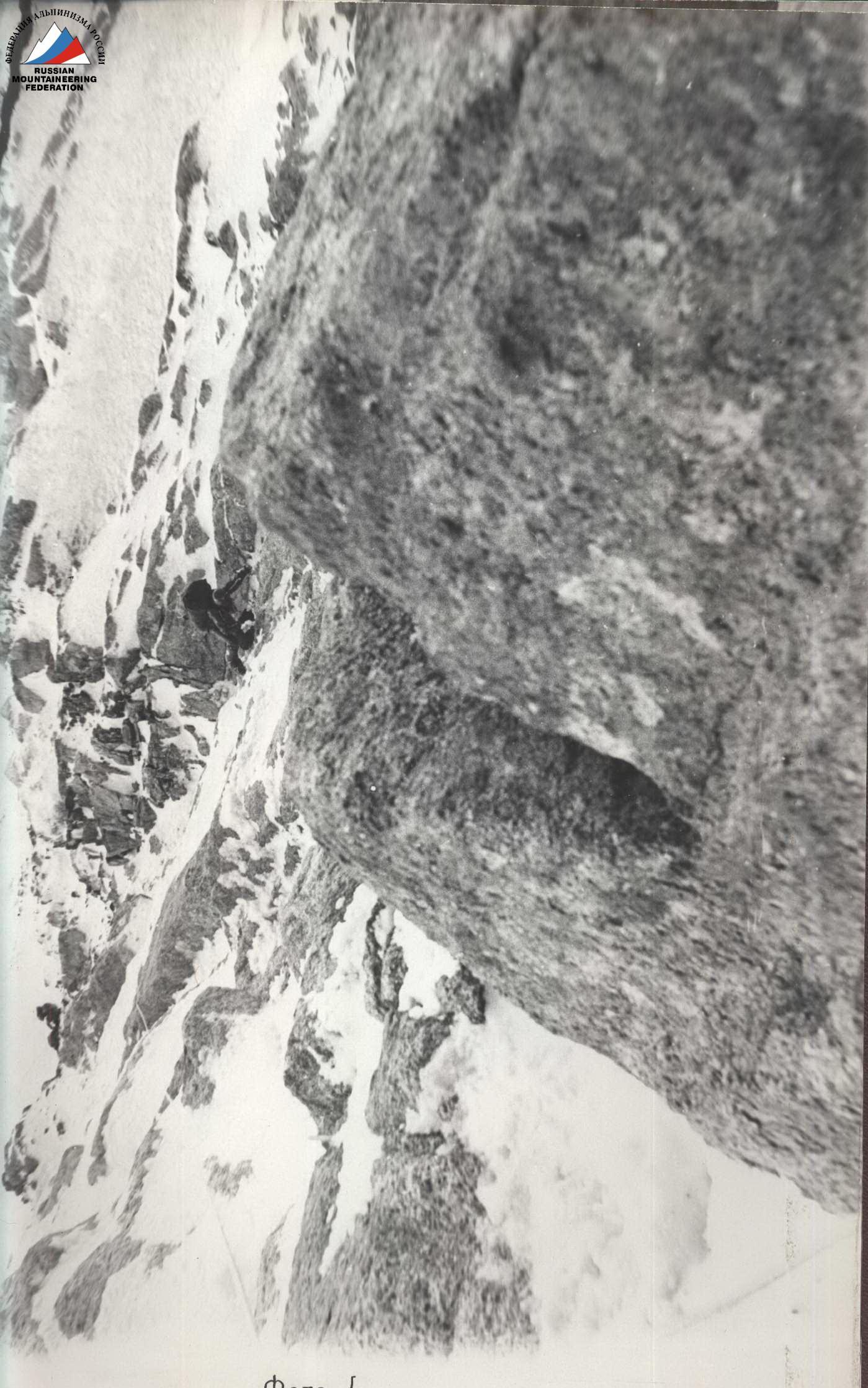
Photo 1
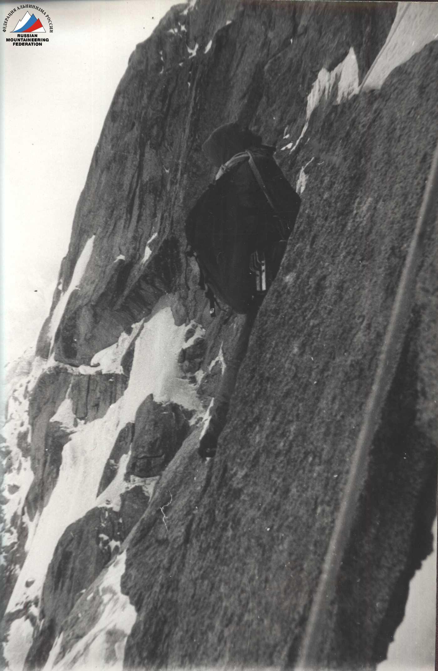
Photo 2
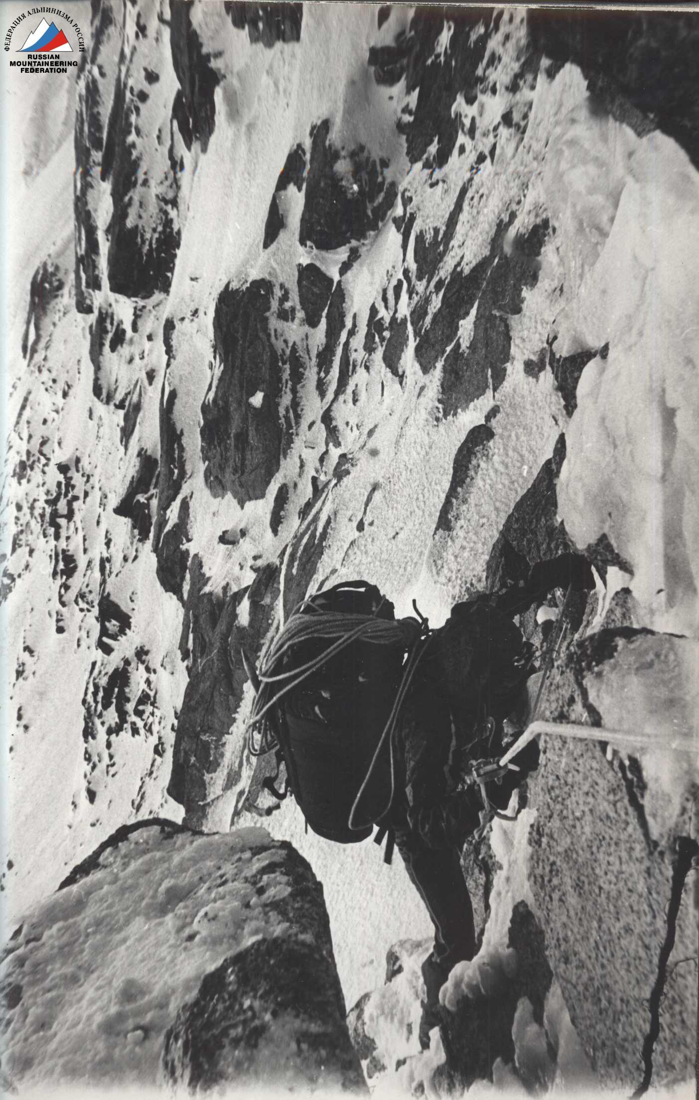
Photo 3
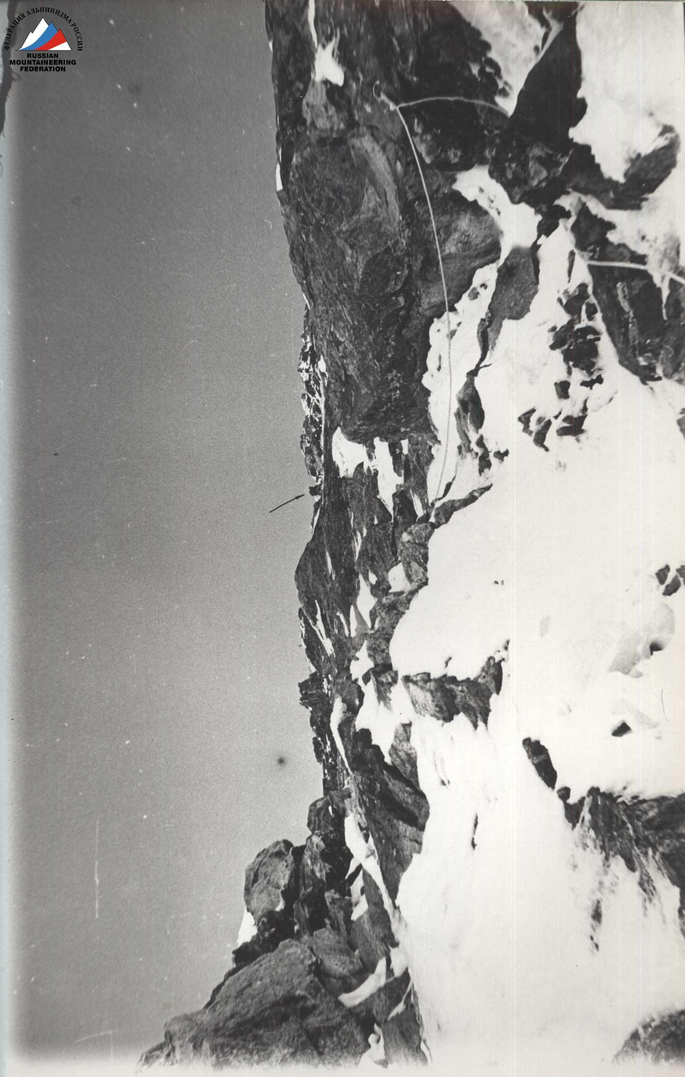
Photo 4
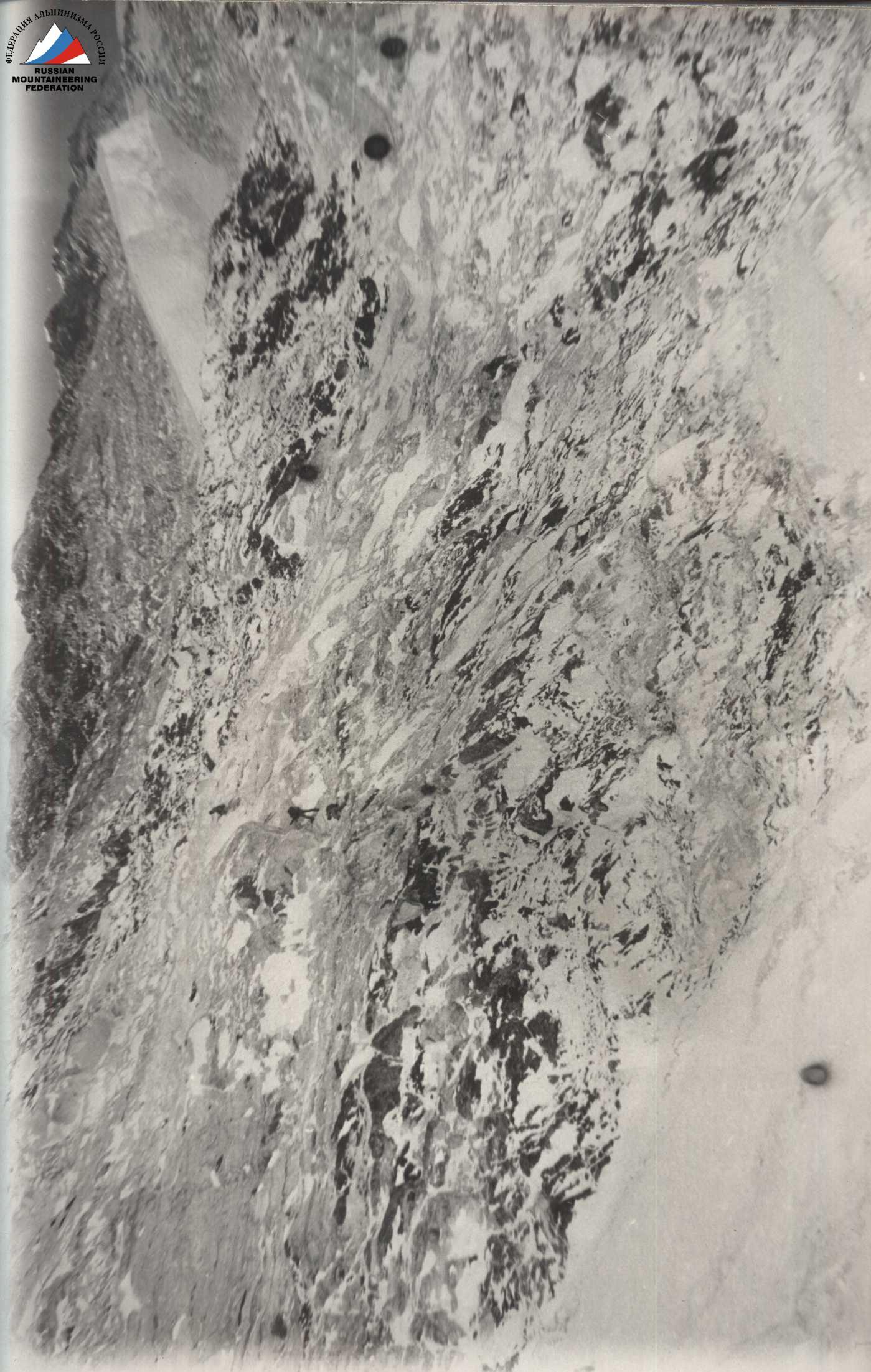
Photo 5
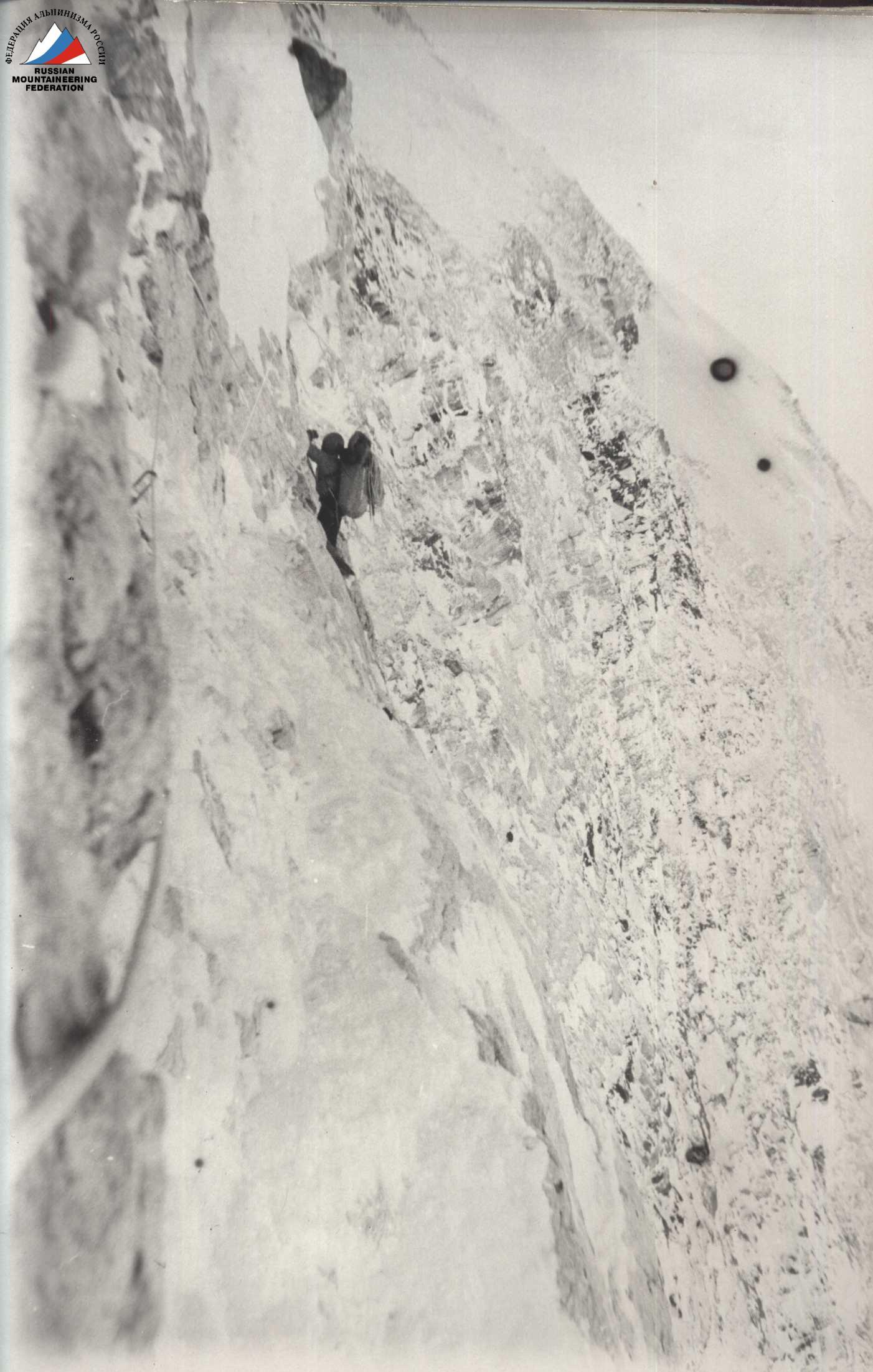
Photo 6
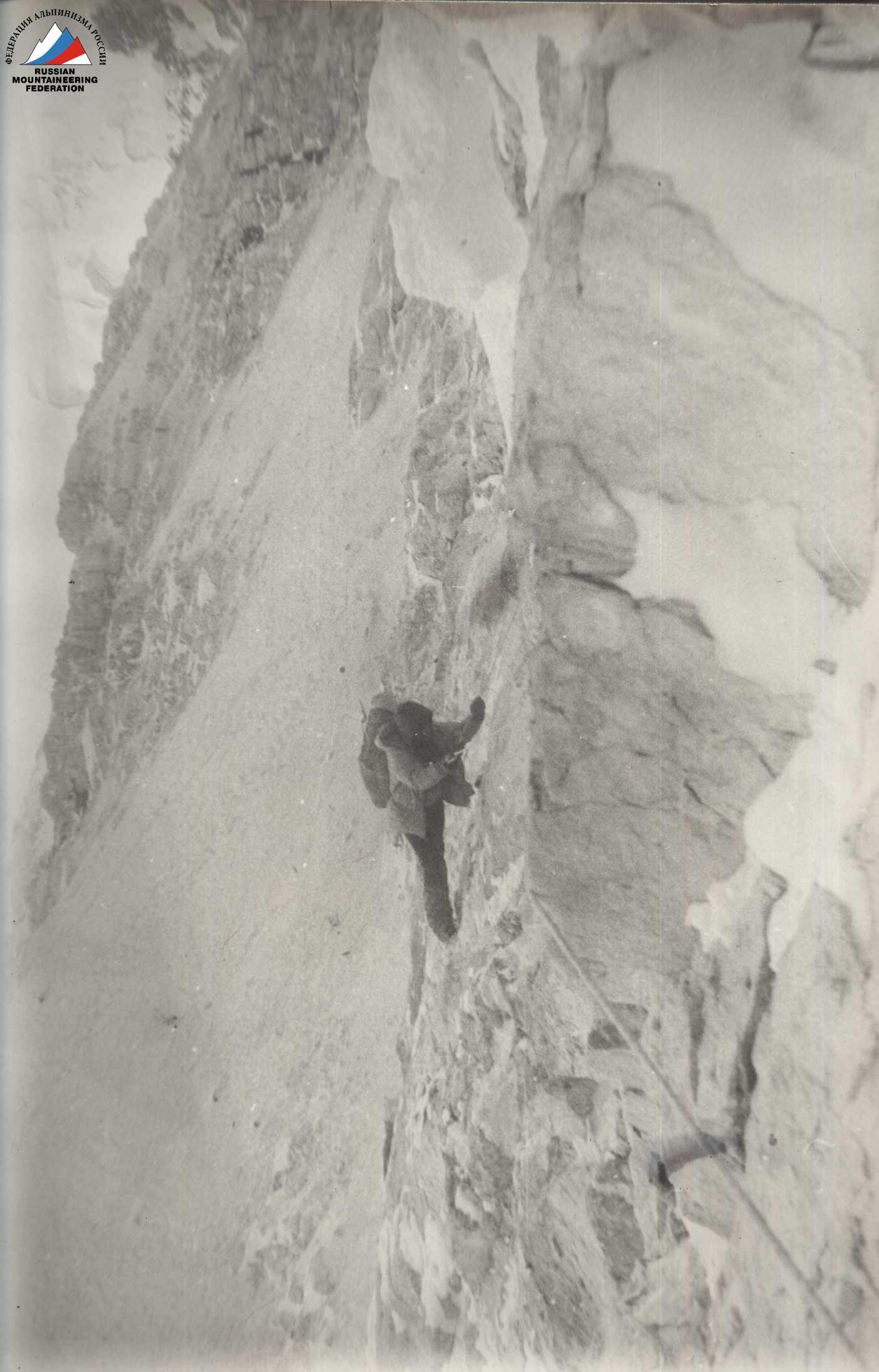
Photo 7
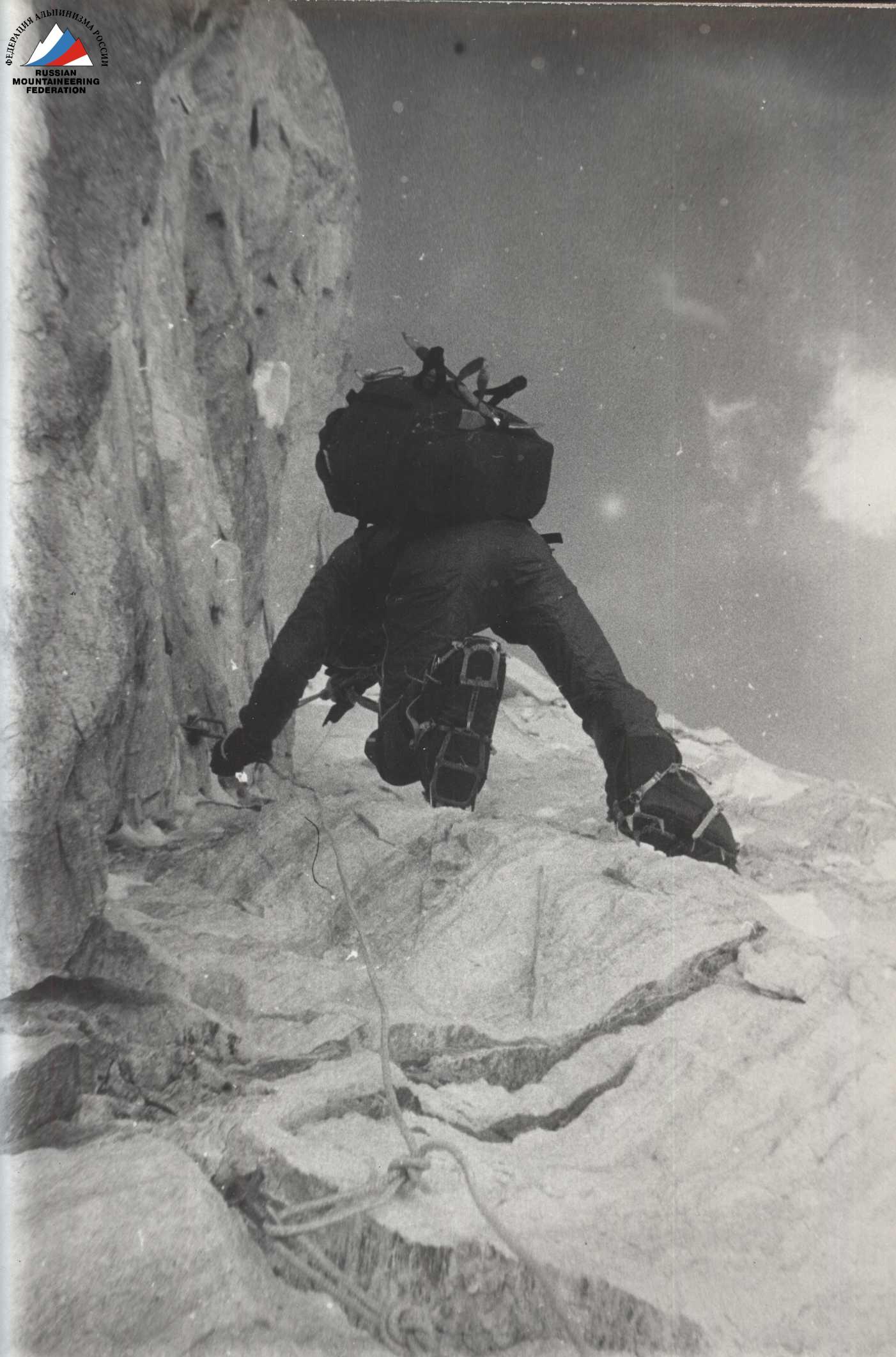
Photo 8
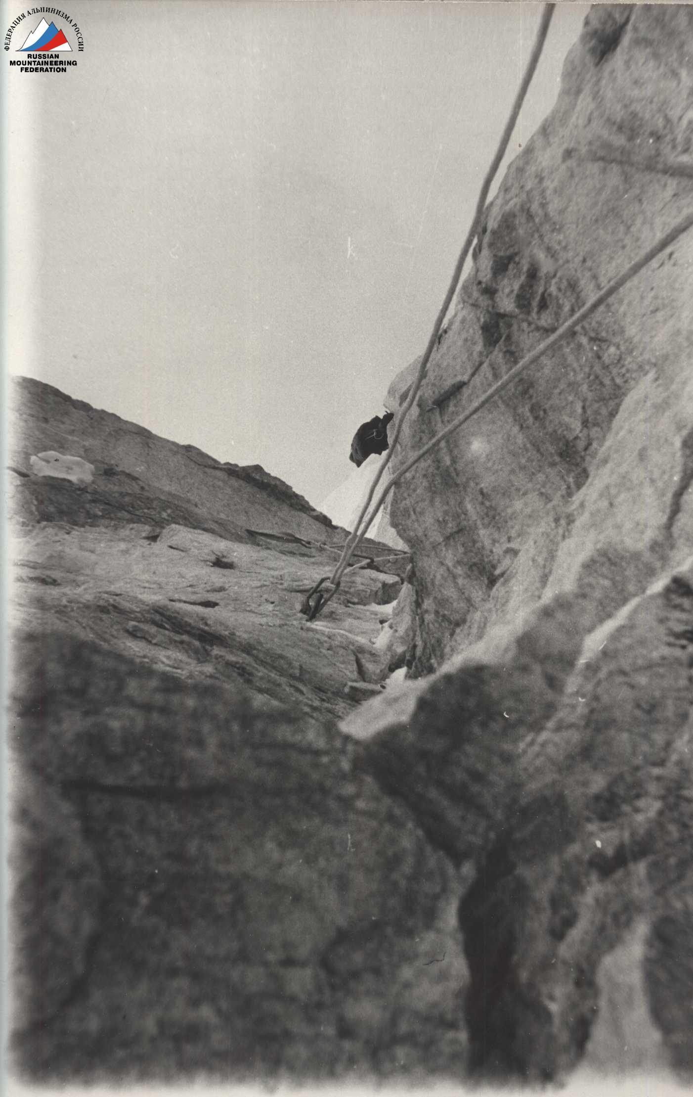
Photo 9
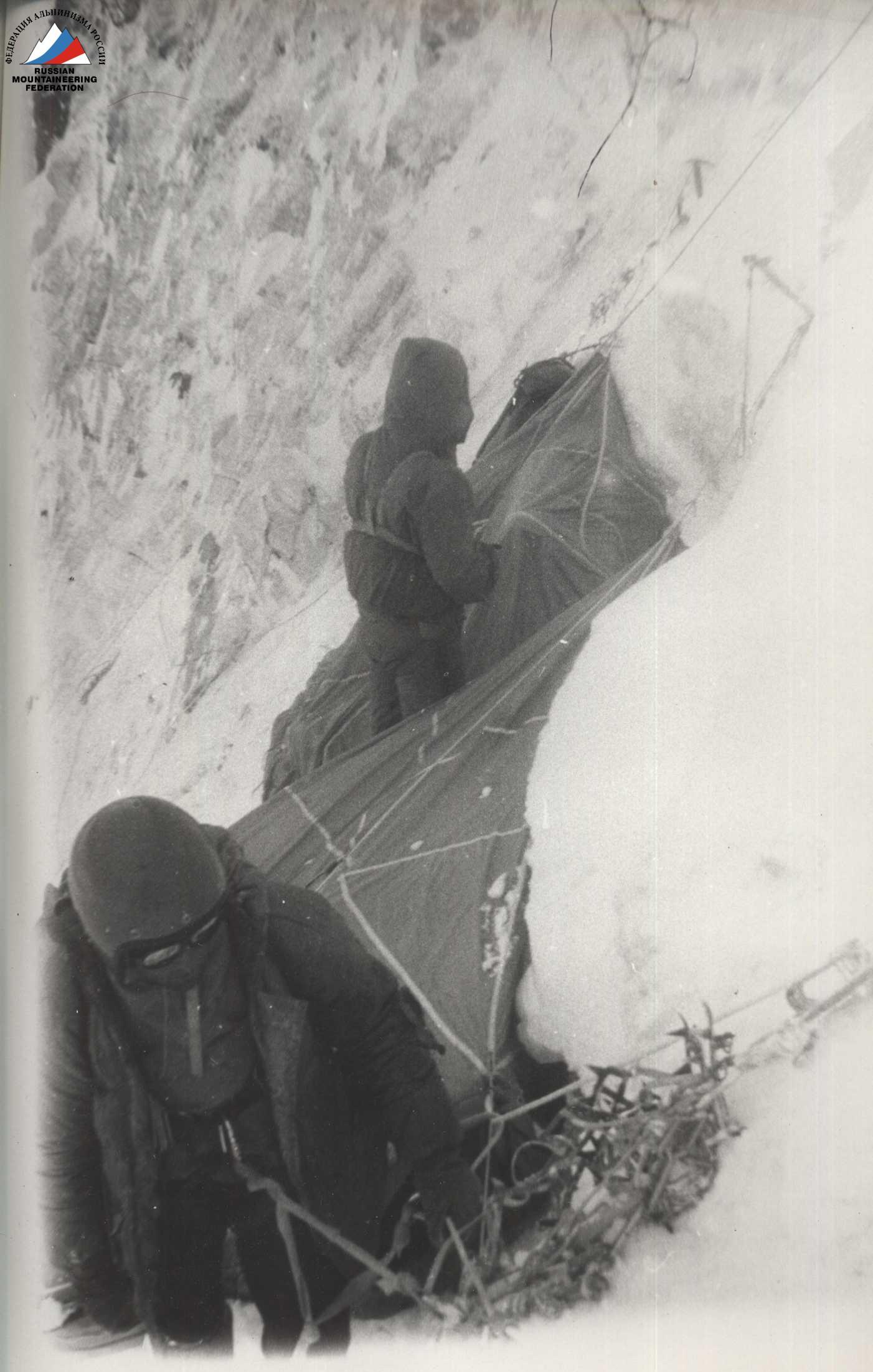
Photo 10
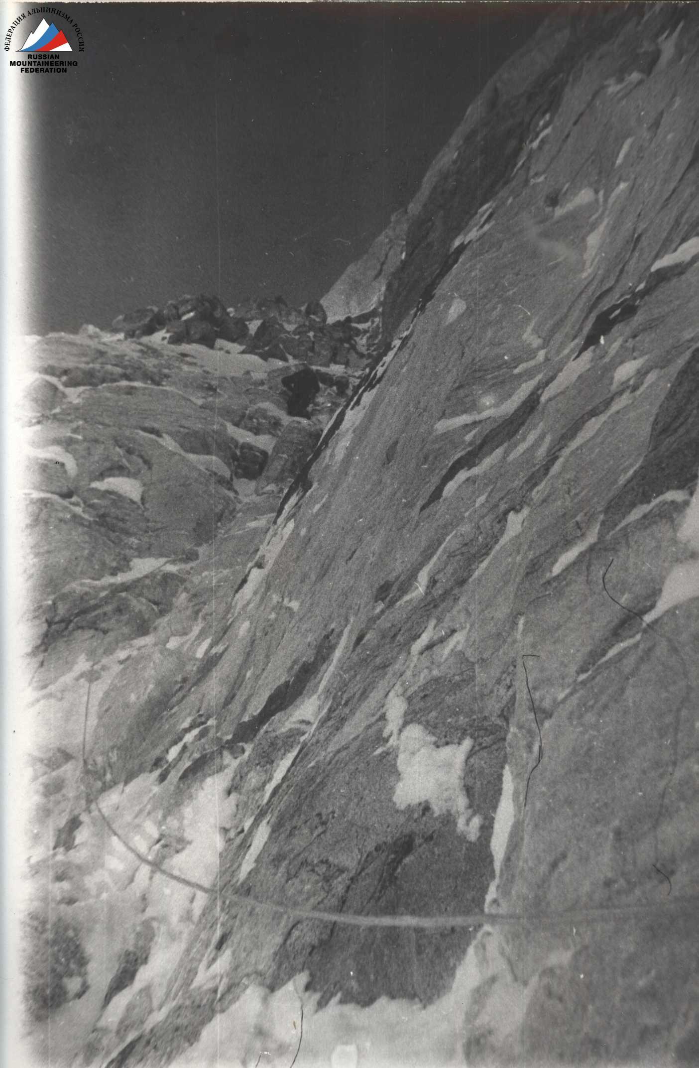
Photo 11
Photo 12
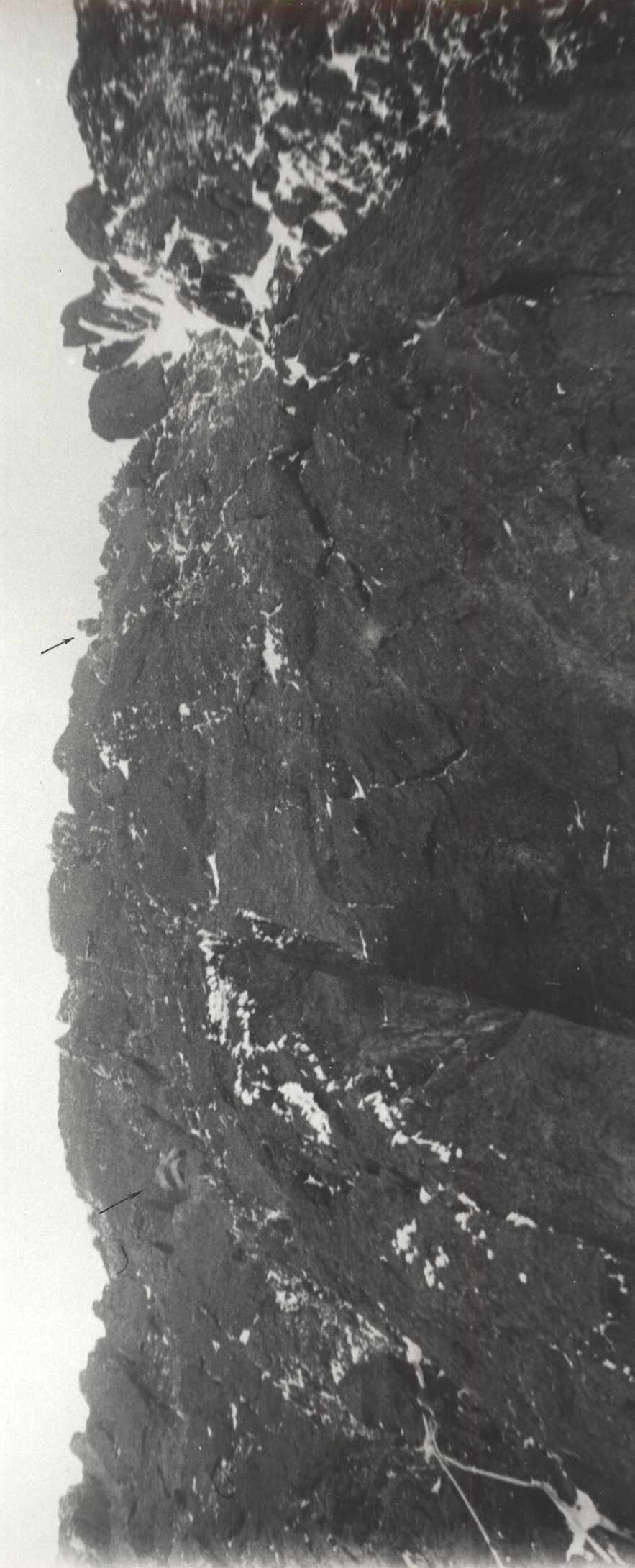
Photo 13