Passport
- High-altitude category
- Tian-Shan, Inylchek gorge
- Pobeda Eastern peak (7060 m) via the north face
- Category 6B assumed, first ascent
- Height difference 2000 m, length — 2560 m (face)
- Length of sections with 5–6 difficulty categories — 2540 m
Average steepness of the main part of the route 68° (5000–7000 m), including 6th category difficulty — 92° (6170–6180 m), 90° (5180–5200 m, 5830–5865 m, 6022–6040 m, 6215–6250 m, 6363–6380 m, 6945–6955 m), 80° (5055–5070 m, 5142–5160 m, 5630–5785 m, 5885–6000 m, 6930–6945 m), 75° (6965–7000 m), 70° (5800–5818 m).
- Pitons driven
| Rock | Bolt | Nuts | Ice |
|---|---|---|---|
| 270/50 | 6/2 | - | 115/– |
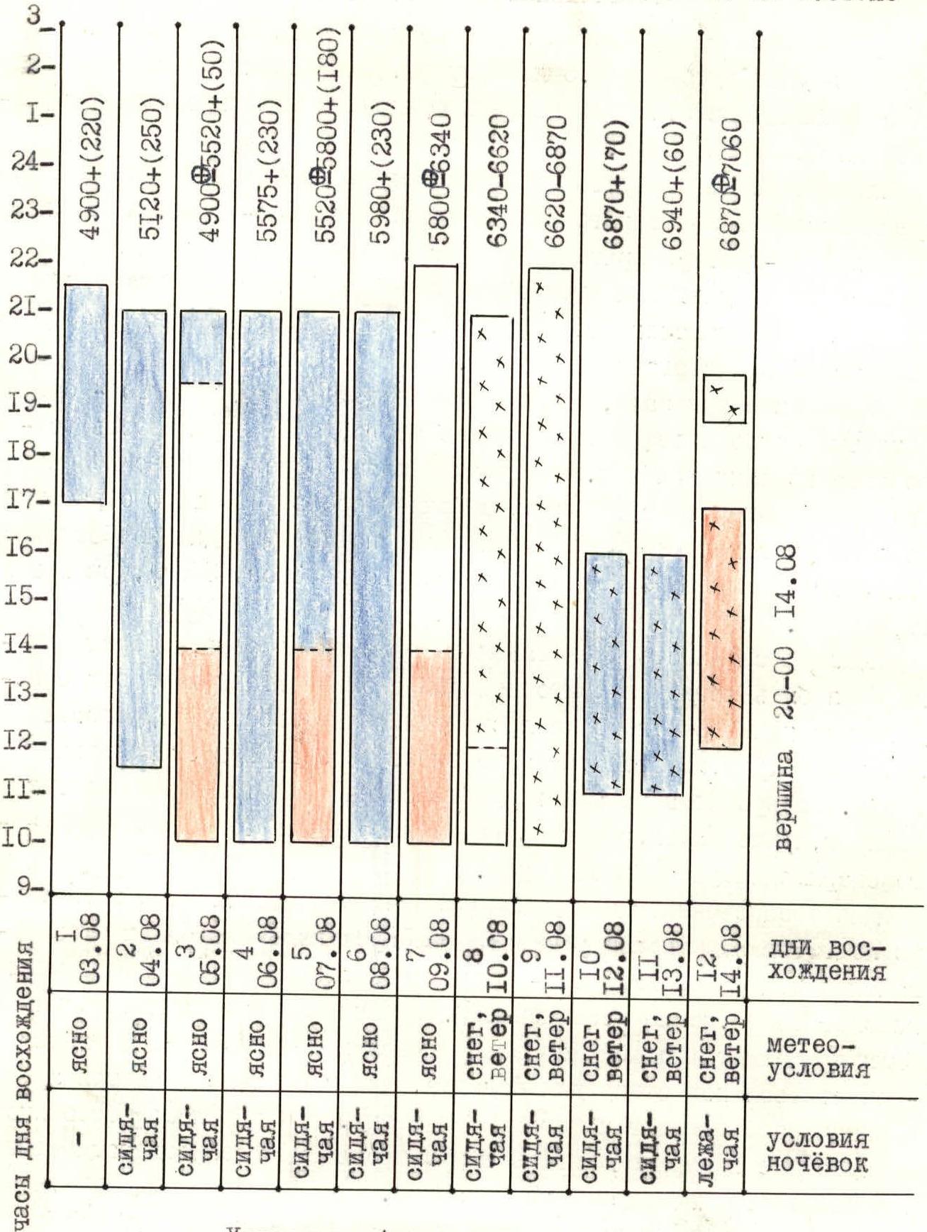
- Team's total hours 117.5 (face, to the summit — 118.5) and days 11.5 (1.5 days of processing, 10 days — ascent)
- Overnights: 1st — 10th sitting on shelves cut in ice; 11th lying on snow (on the ridge)
- Leader: Solonnikov Viktor Aleksandrovich, Master of Sport of International Class
Team members:
- Portnyagin (likely a typo, the name is given as Ведерников Vladislav Valentinovich) Vladislav Valentinovich, Master of Sport
- Stepanov Nikolai Vasil'evich, Master of Sport
- Temirov Anatoliy Magomedovich, Master of Sport
- Voronov Aleksandr Anatol'evich, Candidate for Master of Sport
- Tsaruk Igor' Fedorovich, Candidate for Master of Sport
- Ban'kovskiy Mikhail Georgievich, Candidate for Master of Sport
- Ermakov Boris Ivanovich, Candidate for Master of Sport
- Coach: Solonnikov Viktor Aleksandrovich, Master of Sport
- Entry to the route August 3, 1984 (August 3–4, 1984 — processing, start of ascent — August 5, 1984)
Summit: August 14, 1984
Return: August 17, 1984 12. Organization: Central Council of the All-Union Voluntary Sports Society "Trud" (Leningrad Oblast Council)
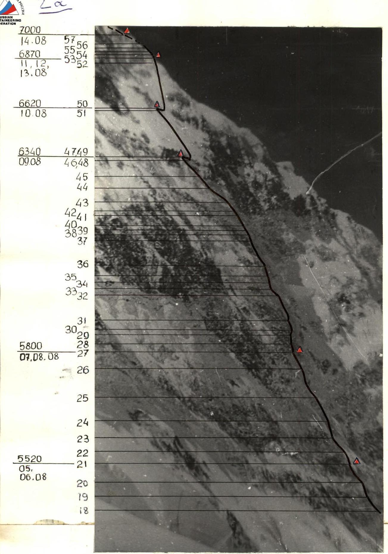
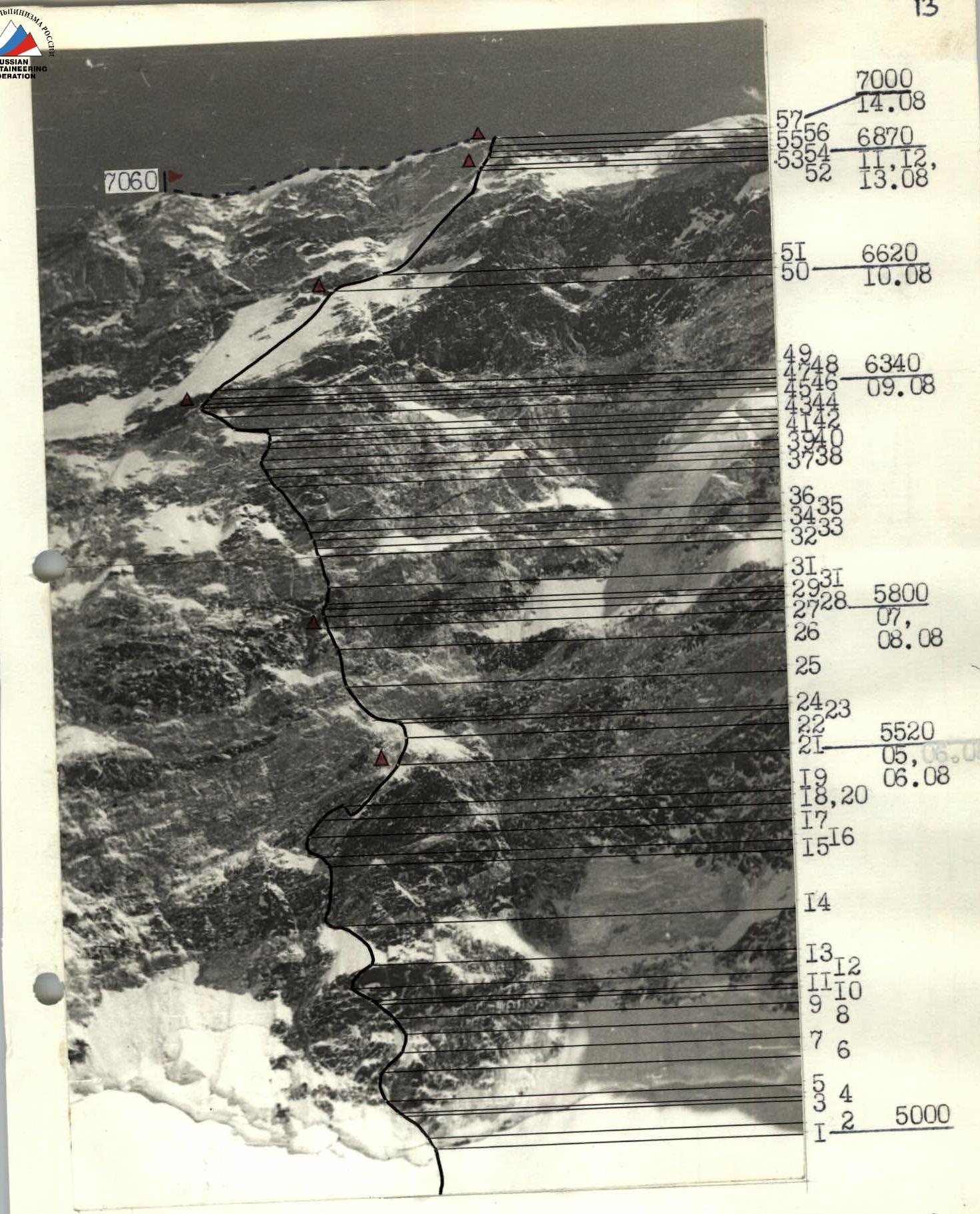
Pobeda Eastern peak 7060 m via the north face A — overnights, altitude — path of the team of the Central Council of the All-Union Voluntary Sports Society "Trud" — path of the team of the Central Council of the Sports Society "Spartak" (approximate), the path of the team of the [likely SA] is not plotted, as the ascent was made later and information about it is not available
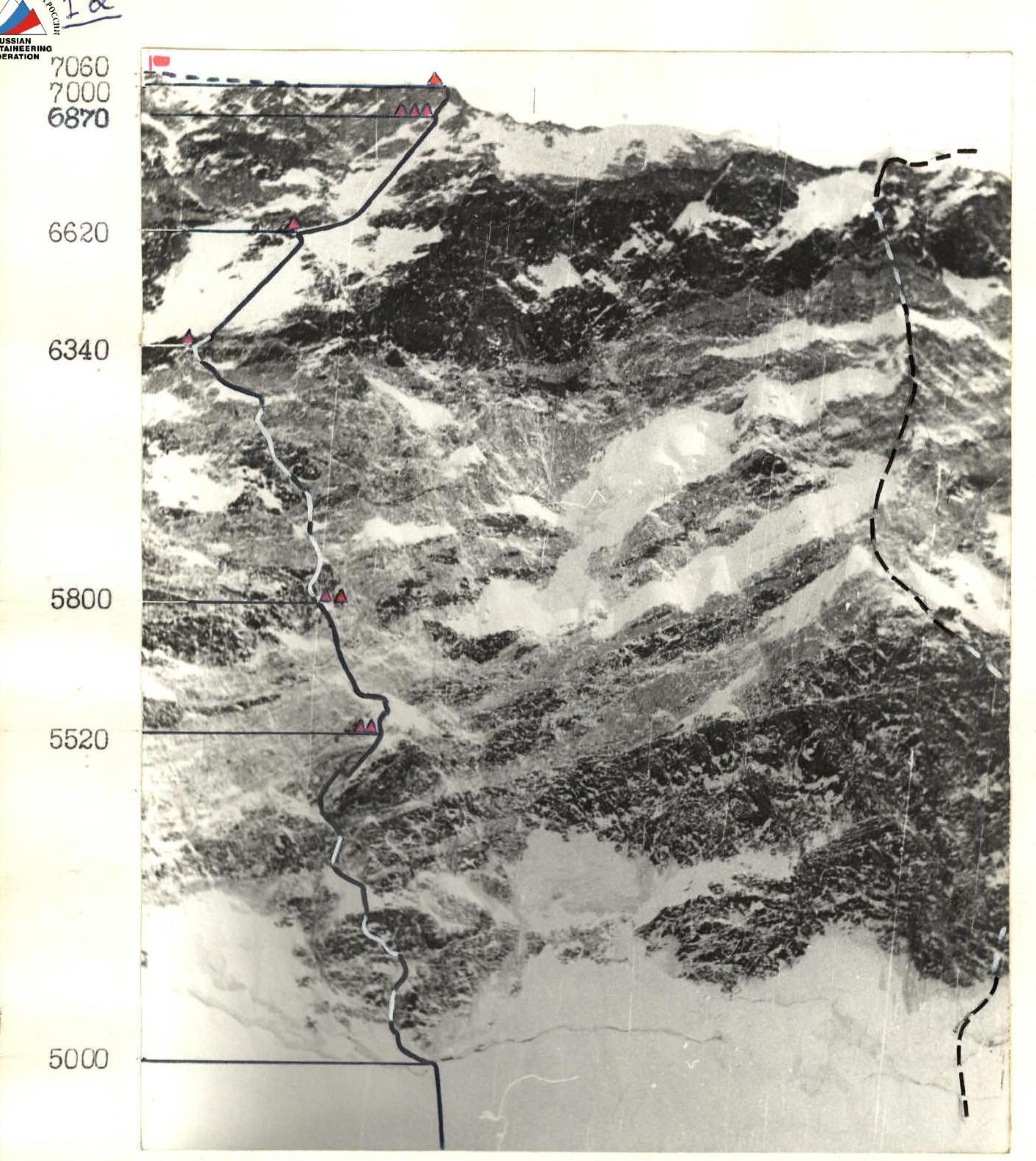
T-43 lens, focal length 4 cm, August 8, 1984, distance 3 km, height 4950 m, point on the diagram №2
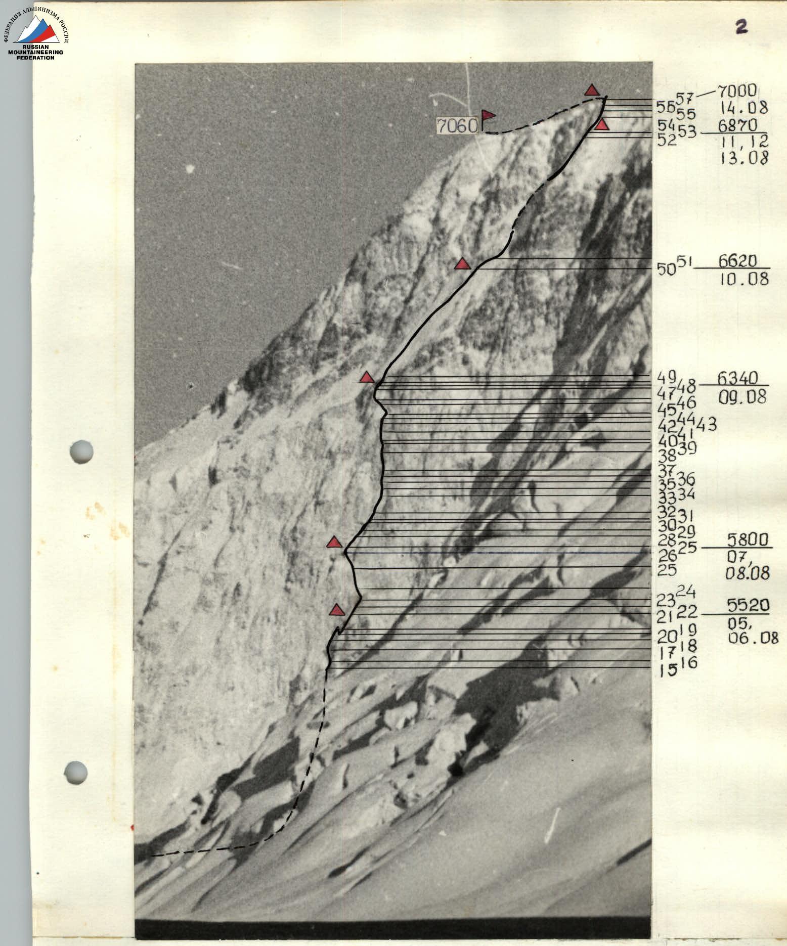
Profile of the face on the right July 29, 1984, 12:00, point on the diagram №1, T-43 lens, focal length 4 cm.
△ Overnights:
- Altitude
- Date
- Distance 11.5 km
- Altitude 4300 m
Profile of the face on the left. A — overnights, altitude, date July 28, 1984, point on the diagram №4, T-43 lens, focal length 4 cm, distance 2 km, height 5500 m.
Preliminary information about the area and the object of the ascent, drawn from the literature mentioned on sheet 5, was supplemented:
- by consultations with Leningrad climbers who have been in this area;
- by studying their photographic materials.
Route observation was conducted from the camp under the face and during the acclimatization exit to the Chon-Teren pass. Observation was carried out with a 60x telescope.
Although, according to the results of the draw, the team was forced to abandon the pre-planned option, it was possible to choose a new route, safe and quite logical.
The observation showed that the main problem on the route is the poorly developed macro-relief and, as a result, the low probability of arranging good overnights. The tactical plan (transmitted to the Championship judge) provided for double overnights and preliminary processing of large sections of the route to the most suitable places for overnights. For this, a large quantity was taken:
- ropes (550 m);
- pitons;
- carabiners.
Considerable difficulty was also presented by the equipment, which had to be light and suitable for complex wall work with uncomfortable overnights, while also taking into account the known severity of local winds, bad weather, as well as the altitude and northern exposure of the face. This problem was solved by:
- strengthening and insulating "Pamirka" tents;
- using high-quality down and windproof equipment;
- using insulated boots.
To provide the team with information about the state of the ridge, as well as to carry out more effective insurance, the team planned to exit from the Chon-Teren pass to the summit, ahead of the support group. After reaching the summit, four of them were to continue climbing to Pobeda Main, and the remaining four were to descend under the face to provide insurance as part of the rescue team working on the lower part of the face. It was planned to have a doctor constantly present in the upper camp, to conduct radio communication sessions, and to visually monitor the team.
In preparation for the ascent, the team carried out a large amount of work on physical and technical training:
- running;
- skiing;
- rock climbing.
Submission of control standards was carried out on rocks in the Leningrad region, on ice — on the icefall of the Zvezdochka glacier, physical training — in the area of the Inylchek outpost. All participants passed the standards "good" and "excellent", the protocols are presented to the Championship judge.
Map-diagram of the ascent area M 1:1 000 000 (1 cm = 1 km)
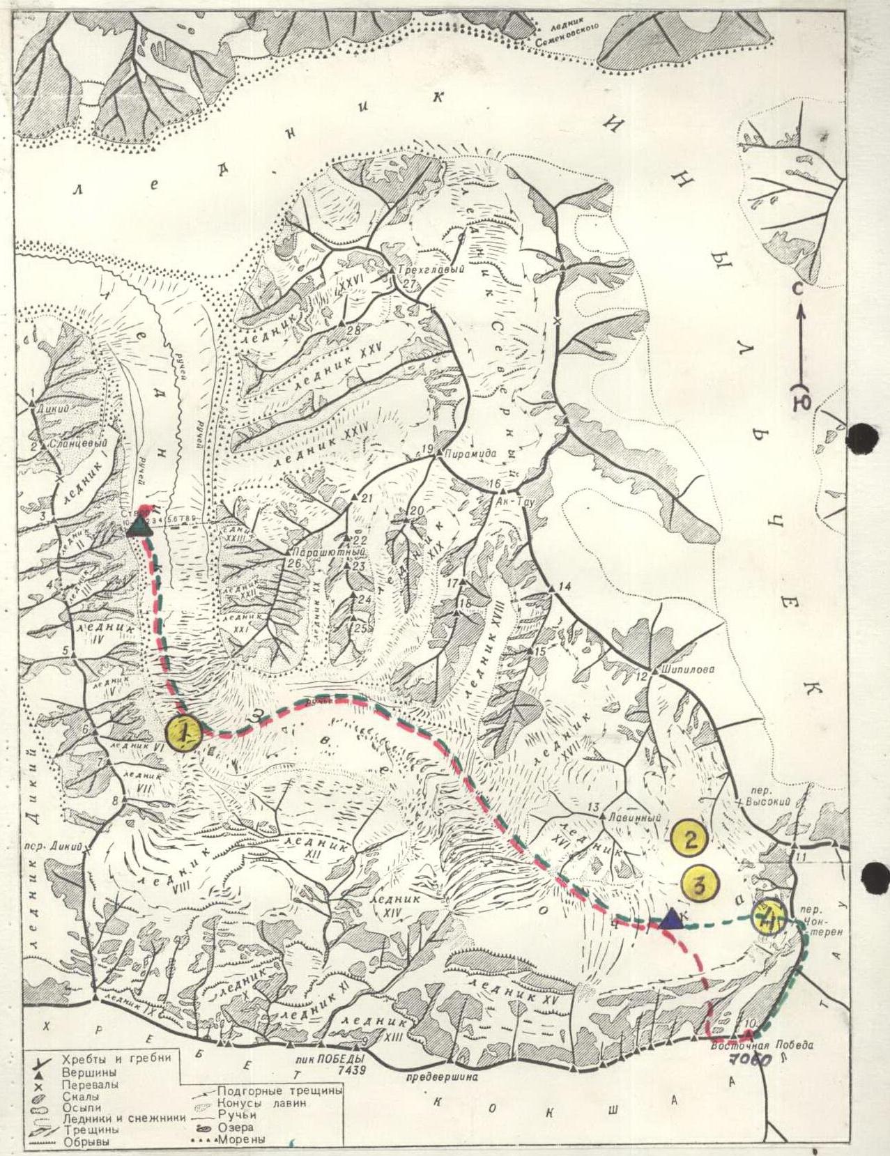
Symbols
- approach path
- descent path
base camp A — observer camp.
Diagram of the ascent to Pobeda Eastern peak (7060 m) via the north face
Symbols
including passage of previously processed sections
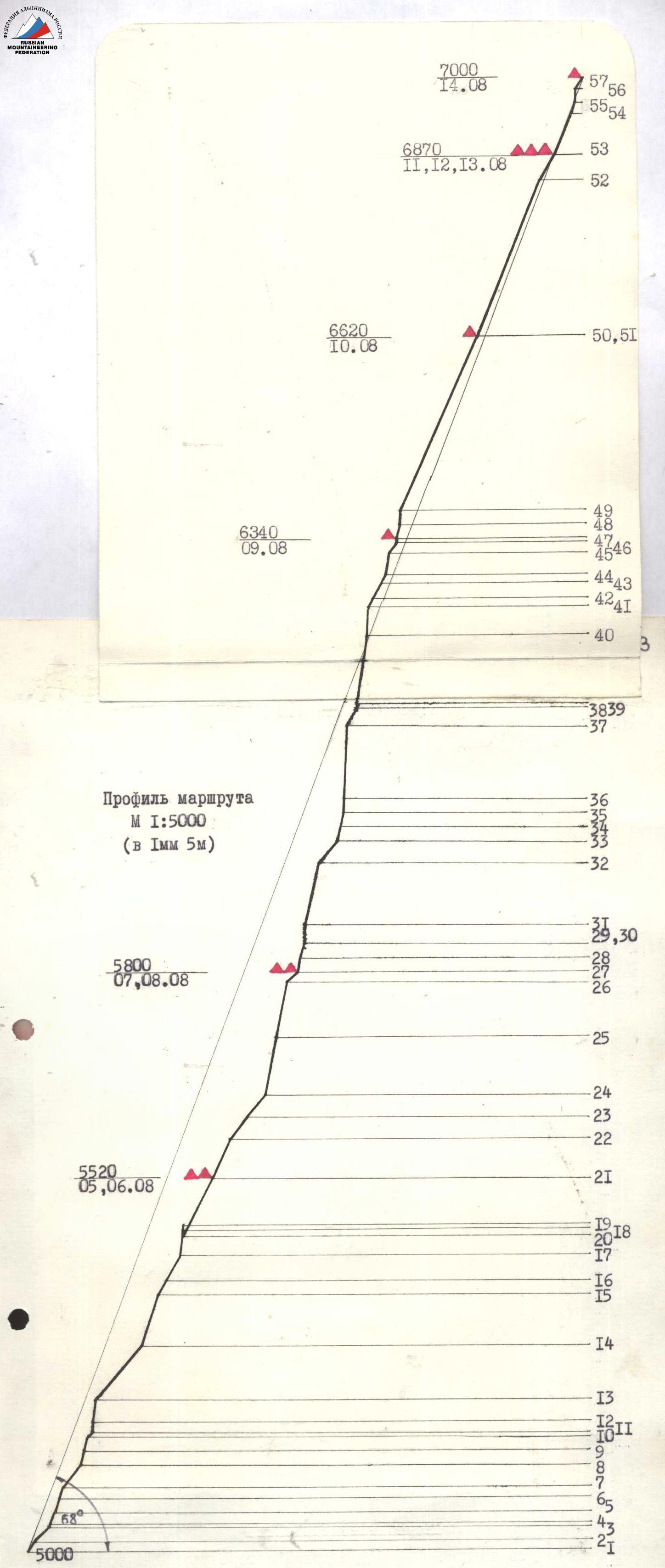
The team's actions on the route were determined by the tactical plan, to which adjustments were made as it was implemented. Nevertheless, the main provisions of the plan were maintained — processing of long sections of the route to places suitable for overnights, then — passage of the processed sections by the entire team on fixed ropes. Implementation of the tactical plan and deviations:
-
Upon subsequent clarification of altitude marks on reliable maps, the height difference (only the face) was 2000 m (adopted in the plan as 1600 m from the glacier to the summit). The discrepancy between the representations of the length of the sections and their actual length caused a lag behind the planned schedule, although the team reached the first double overnight on schedule.
-
The first days of work on the route showed that the depressions of the micro-relief on the rocks are filled with ice, despite the small amount of snow and relatively warm weather. This created great difficulties in the work of the first and organization of insurance. In addition, the slopes, which seemed snowy from below, turned out to be covered with shiny blue ice. All this significantly reduced the expected pace of movement.
-
On August 13, the team received a message about the illness, and early in the morning on August 15 — about the death of a member of the support group Tolsty. Due to the fact that the leadership of the combined rescue team ordered the remaining members of the Dubovikov group to descend to the west, it was decided to return the team via the Chon-Teren pass to help them on the descent.
When moving along the route, daily changes of the first were made, but during the day, the participant going ahead was not changed. The rest moved along the fixed ropes throughout the route, the last one — with upper insurance. The load of the first was distributed among the participants, he worked without a backpack. In addition to the leader, another rope team provided processing, carrying out a straightening of the route and carrying equipment. Throughout the entire route, the entire team, including the first, worked in crampons.
Schedule of work by the first:
| Date | Sections | Action | Participants |
|---|---|---|---|
| 03.08. | R0–R8 | Processing | Voronov |
| 04.08. | R8–R16 | -"- | Tsaruk |
| 05.08. | R16–R21 | Passage without processing | Temirov |
| 05.08. | R21–R22 | Processing | Temirov |
| 06.08. | R22–R27 | -"- | Vedernikov |
| 07.08. | R27–R33 | Processing | Solonnikov |
| 08.08. | R33–R40 | -"- | Stepanov |
| 09.08. | R40–R47 | Passage without processing | Voronov |
| 10.08. | R47–R50 | -"- | Ermakov |
| 11.08. | R50–R53 | -"- | Ban'kovskiy |
| 12.08. | R53–R55 | Processing | Tsaruk |
| 13.08. | R55–R57 | -"- | Vedernikov |
When moving, the whole group managed to catch up and bring equipment to the first, without slowing down his movement, that is, it moved at the speed of a pair.
Despite the fact that there are no platforms, shelves, or gentle areas along the entire route, overnights were organized in tents, together. Shelves for all overnights were cut in the ice.
The team's insurance was ensured by the presence of a rescue team of qualified climbers in the ascent area. On August 7, when the support group was to descend from Eastern Pobeda to be part of the rescue team directly under the face, the team was still at the first double overnight, with a full supply of ropes, sufficient (560 m) for a direct descent in case of need to the beginning of the route.
Safety on the route was ensured by:
- choosing an objectively safe path;
- arranging overnights;
- insurance points and fixing ropes in protected places;
- using proven high-quality equipment;
- working the first on a double import rope.
The absence of clear anchor points on the face and the relative uniformity of the relief made it difficult to orient on the route, so the team chose the most logical path, periodically consulting with observers. After passing the main rock massif (from the third overnight), excess ropes were dropped onto the glacier.
From new equipment samples, rigid crampons of the latest model and ice axes — "ice fifis" were actively used — all ice sections, as well as ice-covered rocks, were passed only on them.
On the sixth day of the ascent (August 10), the weather deteriorated sharply. A strong wind rose, and snowfall began. Streams of dry snow constantly came down from the slope, not lingering on the smooth ice — all the remaining days until the ridge, from August 10 to August 14. This was especially a hindrance when passing a section of complex rocks before the ridge. Tents installed on the ridge were covered with a meter layer of snow in a few hours. Bad weather continued during the descent, with almost zero visibility.
Communication with observers was carried out using "Lastochka" radio stations at the times specified in the radio communication schedule.
| 1 | 2 | 3 | 4 | 5 | 6 | 7 | 8 | 9 | 10 | 11 | 12 |
|---|
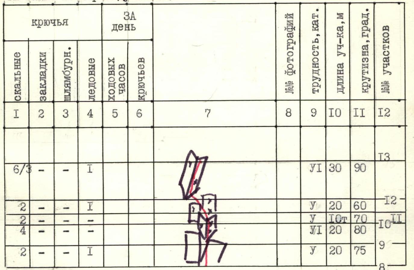
480 m of processed sections were passed and another 250 m to the overnight.
260 m processed per day
| 6 | - | - | - | 11 | 48/12 |  | 40 | 65 | 40- | |||
|---|---|---|---|---|---|---|---|---|---|---|---|---|
| 3/3 | - | - | - | 10 | 92 | 39- | ||||||
| 6 | - | - | - | 30 | 6570 | 38 | ||||||
| 15 | - | - | - | 120 | 60 | 37 | ||||||
| 7/1 | - | - | - | 20 | 90 | 36 | ||||||
| 5/1 | - | - | - | 20 | 70 | 35 | ||||||
| 6/4 | - | - | - | 20 | 80 | 34- |
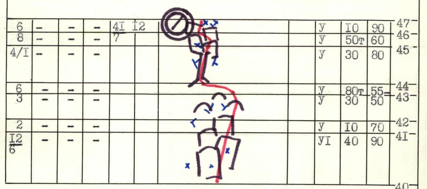
Diagram of the route in symbols M 1:2000 (1 mm = 2 m) in height. Sections of traverses (T) are also taken according to the height difference.
Processed for the day 280 m, including:
- face — 160 m
| - | - | - | 3 | 4,520 | |||||||||
|---|---|---|---|---|---|---|---|---|---|---|---|---|---|
| 3 | |||||||||||||
| - | - | - | 3 | ||||||||||
| - | - | - | 4 | ||||||||||
| - | - | - | 3 | ||||||||||
| - | - | - | 2 | ||||||||||
| - | - | - | 2 | ||||||||||
| - | - | - | 2 | ||||||||||
| - | - | - | - | ||||||||||
| 1 | 2 | 3 | 4 | 5 | 6 | 7 | 8 | 9 | 10 | 11 | 12 | ||
| :-- | :-- | :-- | :-- | :-- | :-- | :-- | :-- | :-- | :-- | :-- | :-- | ||
| 23- | |||||||||||||
| 22- |
580 m of processed sections were passed for the day, including:
- 360 m — face
- further to overnight — another 240 m
- processed from overnight — 60 m
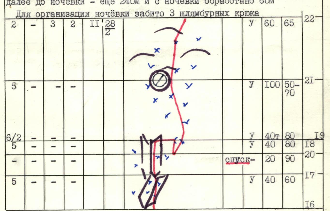
300 m processed per day
| - | - | - | 3 | 9,5 | 42 | х | 20 | 60 | 16- | ||
|---|---|---|---|---|---|---|---|---|---|---|---|
| 12/2 | - | - | 3 | 80 | 70 | 15- | |||||
| 2 | - | - | 3 | 100 | 50 | 14- | |||||
| 13 | |||||||||||
| 1 | 2 | 3 | 4 | 5 | 6 | 7 | 8 | 9 | 10 | 11 | 12 |
| :-- | :-- | :-- | :-- | :-- | :-- | :-- | :-- | :-- | :-- | :-- | :-- |
260 m of processed sections were passed to overnight, processed further — another 220 m.
| 8 | - | - | 1 | 11 | 48 | 40 | 50 | 33 | |||
|---|---|---|---|---|---|---|---|---|---|---|---|
| 16 | - | - | - | 90 | 75 | 32 | |||||
| 10/5 | - | - | 1 | 30 | 90 | 31 | |||||
| 3 | - | - | - | 20 | 80 | 29,30 | |||||
| 5/2 | - | - | - | 20 | 80 | 28 | |||||
| 4 | - | - | - | 20 | 70 | 27 |
260 m processed per day to overnight
| - | - | - | 3 | 11 | 47 | 20 | 50 | 27 | |||
|---|---|---|---|---|---|---|---|---|---|---|---|
| 18 | - | - | - | 80 | 80 | 26 | |||||
| 7 | |||||||||||
| 16 | - | - | 3 | 80 | 80 | 25 | |||||
| 5 | |||||||||||
| 2 | - | - | 2 | 40 | 50 | 24 | |||||
| 23 | |||||||||||
| 1 | 2 | 3 | 4 | 5 | 6 | 7 | 8 | 9 | 10 | 11 | 12 |
| :-- | :-- | :-- | :-- | :-- | :-- | :-- | :-- | :-- | :-- | :-- | :-- |
| 1 | 2 | 3 | 4 | 5 | 6 | 7 | 8 | 9 | 10 | 11 | 12 |
|---|
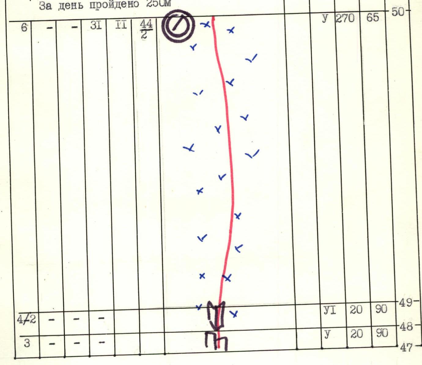
60 m processed to the ridge per day. Passage of processed sections to the ridge and further along the snowy ridge to the summit (height difference 60 m, length 1 km) is not reflected in the diagram.
| Route description by sections | Description of the section and the group's movement |
| R0–R1 | Snowy slope. Simultaneous movement. |
| R1–R2 | Exit through the bergschrund and movement in crampons along the icy slope covered with a thin layer of snow. |
| R2–R3 | Icy slope of pure blue ice with embedded stones. Movement on ice axes. Insurance via ice screws. |
| R3–R4 | Traverse along the slope to the left with a small gain in height. |
| R4–R5 | Ascent along the slope on ice axes to the icy ledge. |
| R5–R6 | Steep icy wall. Movement on ice axes. |
| R6–R7 | "Ram's foreheads" covered with ice. Insurance is difficult: cracks in the rocks are filled with ice, due to the thin layer of ice, it is difficult to find a place for ice screws. Movement on ice axes. |
| R7–R8 | Icy slope with protruding stones. Ice axes. |
| R8–R9 | Monolithic slabs. Few cracks for driving pitons, small holds. |
| R9–R10 | Icy internal corner. Ice screws cannot be screwed in, cracks in the rock are filled with ice. Movement in crampons, climbing is extremely tense. |
| R10–R11 | Traverse to the left along icy slabs, in crampons. |
| R11–R12 | Approach along icy slabs to the internal corner. |
| R12–R13 | Overhanging internal corner and steep slabs. Insurance via rock pitons, climbing with artificial holds on ladders. |
| R13–R14 | Icy slope. Movement in crampons with the use of ice axes, to the left under the rocks. |
| R14–R15 | Icy gutter with stones. Movement in crampons and on ice axes, insurance mainly via rock pitons. Use of artificial holds when exiting the gutter. |
| R15–R16 | Icy slope covered with a thin layer of loose snow. |
| R16–R17, R17–R18 | Steep rocky-icy internal corner. Rocks are destroyed. Insurance via ice pitons. |
| R18–R19 | Traverse to the right along steep destroyed rocks covered with ice. Use of artificial holds. The section is difficult not only for the first, but also for all other participants, especially the last. |
| R19–R20 | Descent via rappel into the icy gutter. |
| R20–R21 | Movement to the right along the rocks via the icy gutter and snowy-icy slope. |
R21–R22: Icy "ram's foreheads", destroyed. Due to the complexity of finding places for pitons, insurance organization is complicated. R22–R23: Snowy-icy slope. Thin layer of snow on hard ice. R23–R24: Traverse to the left along the rocks via the snowy-icy slope. Insurance via ice pitons. R24–R25: Destroyed rocks — steep, icy internal corner. Movement by free climbing and with the use of artificial holds. R25–R26: Rocky wall with few cracks and holds. Movement by free climbing, in the upper part — on ladders with the use of artificial holds. R26–R27: Snowy-icy slope. Thin layer of snow, underneath a thin layer of ice on the rocks. Insurance via blocked ice screws, as it is not possible to screw them in well. R27–R28: Monolithic, icy steep slab. Free climbing on micro-holds, few cracks. R28–R29: Wall, destroyed rocks. It is necessary to be especially careful, as an overnight is set up below. R29–R30: Traverse to the right along steep destroyed rocks. R30–R31: Destroyed, icy internal corner. In the lower part, movement with the use of artificial holds. R31–R32: Icy large-block destroyed wall. R32–R33: Snowy-icy slope, snow does not stay on the ice. R33–R34: Steep monolithic wall. Movement by pendulum, with the use of artificial holds. R34–R35: Flattened internal corner, inclined, throwing outward. Few cracks. Difficult for movement on fixed ropes and especially for the last. R35–R36: Plumb rocky wall. Path bypassing the cornice. Rocks are monolithic, with few holds. Free climbing. R36–R37: Vertically split slabs, small holds, cracks are filled with ice. R37–R38: Steep monolithic slabs. Tense free climbing. R38–R39: Overhanging wall. Movement with artificial holds. R39–R40: Icy "ram's foreheads". Few places for driving pitons. R40–R41: Plumb, destroyed rocks. Half of the pitons are used as artificial holds — movement on ladders. R41–R42: Slabs with few holds, holds are fragile. R42–R43: Icy light "ram's foreheads", almost no places for driving pitons. R43–R44: Traverse along the icy slope along the rocks. Use of ice axes, insurance via rock pitons. R44–R45: Rocky chimney-gutter, filled with ice. Above the gutter — destroyed slabs.
R45–R46: Traverse along individual icy rocky walls. R46–R47: Plumb snowy wall, passed with the help of driven ice axes. R47–R48: Steep icy slabs. Tense climbing on small holds. R48–R49: Plumb monolithic rocky internal corner. Few cracks. Movement in the upper, icy part — on ladders with the use of artificial holds. R49–R50: Steep, shiny blue icy slope. Streams of dry snow constantly come from above. Movement on ice axes. R50–R51: Traverse to the right along the ice under the rocks. Ice axes. The section is also difficult for the last. R51–R52: Pure blue icy slope. Snow constantly comes from above. At the end of the slope — exit to the icy ridge. Ice axes. R52–R53: Light large-block, icy rocks. Insurance via rock pitons, movement on ice axes. R53–R54: Pure icy slope. Movement towards the rocky massif on ice axes. R54–R55: Extremely destroyed, crumbling steep rocks. Very few places for pitons. A snow stream constantly comes from above, working in gloves is impossible. R55–R56: The same. R56–R57: Steep internal corner, filled with ice. Insurance is complicated, pitons do not hold well. R57–R58: Gentle snowy ridge to the summit.
Technical photograph of the route. △ Overnights — altitude, date August 8, 1984, 16:00, point on the diagram №3, T-43 lens, focal length 4 cm, distance 2 km, height 4900 m.