
Ascent Passport
-
Ascent class — high-altitude.
-
Ascent area — Central Tien Shan.
-
Ascent route — Peak Neru – Western Pobeda.
-
Complexity category — 6B (approximate).
-
Ascent characteristics: route length — approx. 10450 m. height difference — 2750 m. average steepness up to the northern shoulder of Peak Neru — 60°. length of sections with 5th and 6th complexity category — 1010 m.
-
Pitons driven:
- rock — 7
- chocks — 8
- ice — 164
-
Number of travel days: 8 (excluding the approach day).
-
Number of travel hours: 45.5 hours.
-
Overnights: 7 (all lying down, 6 in a tent, one in a cave).
-
Team name: Team of the "Bars" Alpine Club, Saint Petersburg University.
-
Team captain: Reznik V.A. — Master of Sports of Russia.
Team members:
- Pashin A.V. — Master of Sports of Russia
- Uspensky S.M. — Candidate Master of Sports
- Knyazev P.V. — 1st sports category
Team coaches:
- Krasnoukhov Yuri Vasilyevich — Master of Sports of the USSR
- Semiletkin Sergey Alekseyevich — Master of Sports of the USSR
-
Departure to the route: August 19, 1995. Arrival at Peak Neru: August 24, 1995. Arrival at Western Pobeda: August 26, 1995. Return to the base camp: August 28, 1995.
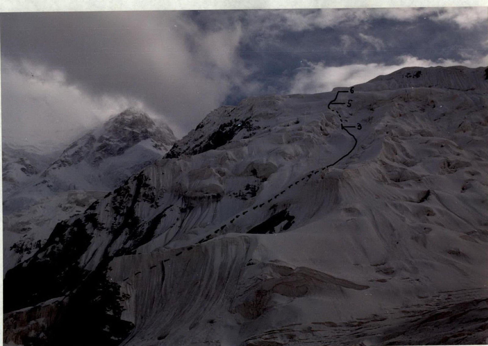 PHOTO #3. Taken from the Diky Glacier on August 17, 1995.
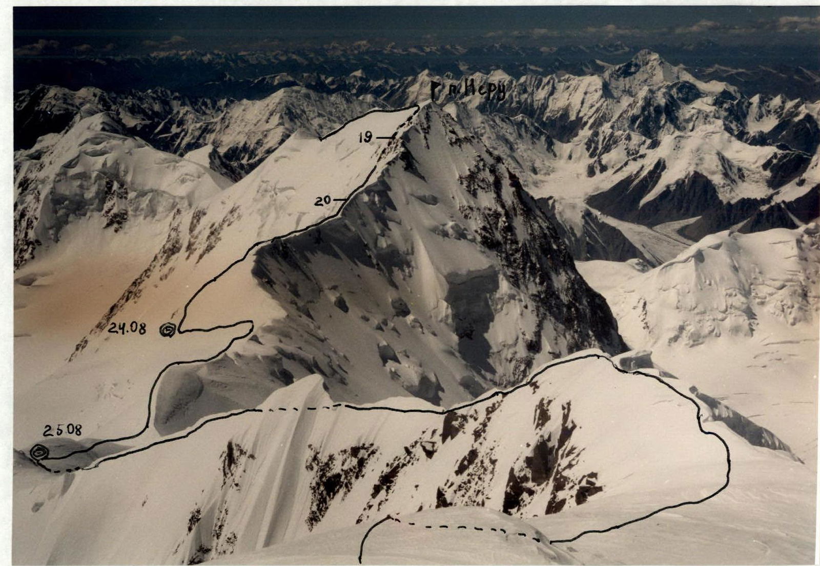 PHOTO #4. Taken from Western Pobeda on August 19, 1995.
Tactical Actions of the Team
The tactical plan for the ascent took into account the highly unstable weather in the ascent area. The team's departure from the MAC was scheduled for August 17, 1995. A support group equipped with radio communication and visual observation means departed with the team. The assault camp was to be located under the route on the Diky Glacier.
Rappel techniques were used for most of the route up to Peak Neru. Initially, all team members worked during the ascent. On the ridge from Peak Neru to Western Pobeda, simultaneous movement with belay was used, primarily through ice screws.
The most challenging sections were R8–R9 ("wavy" ridge) due to their length and numerous snow and ice walls, as well as sections R3–R5 (upper part of the ascent to the northern ridge of Peak Neru).
All overnights were organized in safe locations. Having a shovel allowed for quick organization of lying-down overnights.
The group's nutrition was provided with high-calorie products such as:
- honey
- nuts
- sausage
- dried fruits
- mashed potatoes
- "KNORR" soups
- energy and vitamin-enriched drinks
- others
The descent from Western Pobeda was along the northern ridge. During the ascent, the team maintained stable radio communication with the base camp using an "ALAN-38" radio station.
Description of the Route Passage
August 17. At 11:00, the team and support group departed from the MAC, crossed the South Inylchek Glacier, and then approached the overnight stay at the start of the route via the Diky Glacier (16:00). The remaining daylight was used for observing the route.
August 18. Departure was postponed due to bad weather and avalanche danger.
August 19. The team started the route at 6:00, allowing them to pass the avalanche-prone section early in the morning.
Section R0–R1. Snow slope. Simultaneous movement. The Reznik–Pashin rope leads.
Section R1–R2. Ice slope, traversed using two ice axes. Belay via ice screws.
Section R2–R3. Wide snow and ice couloir. Movement is on the right side, and in the upper part, a transition to the left side towards rock outcrops. Belay via ice screws.
Sections R3–R6. The rope on rocks leads to ice couloirs. Two ropes on vertical ice. Very challenging climbing. Then, an ice ascent to a snow pad and subsequently to the ridge.
Section R6–R7. Simultaneous movement along the western side of the ridge. Deep snow. At 17:00, after 12 hours of work, they began organizing an overnight stay in a cave at an altitude of 5200 m.
August 20. Departed from the overnight stay at 9:30.
Section R7–R8. Simultaneous movement along the ridge. After one rappel on ice, they approached a very sharp ridge (11 hours).
Section R8–R9. Movement along a very sharp "wavy" ridge with numerous cornices, snow, and ice walls. Knyazev leads. Rappel. Movement was hindered by heavy snow and wind. Belay via ice screws.
Sections R9–R11. Moved off the ridge to the right onto rocks towards two "Gendarmes." Rock ascent to a snow pad. Overnight stay in a tent at an altitude of 6000 m.
August 21. Departed at 9:00.
Sections R11–R14. Ice movement:
- ice walls traversed using two ice axes;
- belay via ice axes.
After the ice, an ascent to a snow slope under the rocks of Peak Neru. At 14:00, heavy snowfall started, visibility was zero, so a decision was made to stop for the night. Altitude 6300 m.
August 22. Weather did not improve, heavy snow and wind. No work on the route.
August 23. Departed from the overnight stay at 8:00. Passed 5 ropes on rocks and reached a ledge. It became clear that the only possible ascent route led under large cornices on the ridge to the left of the summit, which was objectively dangerous to pass. Therefore, a decision was made to descend for the night and ascend via the ice to the right of the summit the next day.
August 24. Departed from the overnight stay at 9:00. Uspensky leads. Sections R14–R18.
Approached ice couloirs via snow. Ice walls and then a snow slope leading to rocks to the right of Peak Neru's summit. Reached the summit at 14:00.
Sections R18–R21. Simultaneous movement towards Western Pobeda along the "Chinese" side of the ridge. Rock outcrops. Rappel on rocks. Traverse on ice.
Stopped for the night at 19:00.
August 25. Bad weather. Zero visibility, thunderstorm front. Some improvement in weather towards the evening. Departed at 17:00. Section R21–R22. Simultaneous movement along the ridge. Stopped for the night at 19:00 in a rock niche.
August 26. Departed at 9:00. Very strong wind. Sections R22–R24. Movement along the ridge, ice "knives." Reached Western Pobeda at 14:00. Overnight stay in a cave.
August 27. Descent from Western Pobeda along the northern slope.
Total time to the summit: 45.5 travel hours.
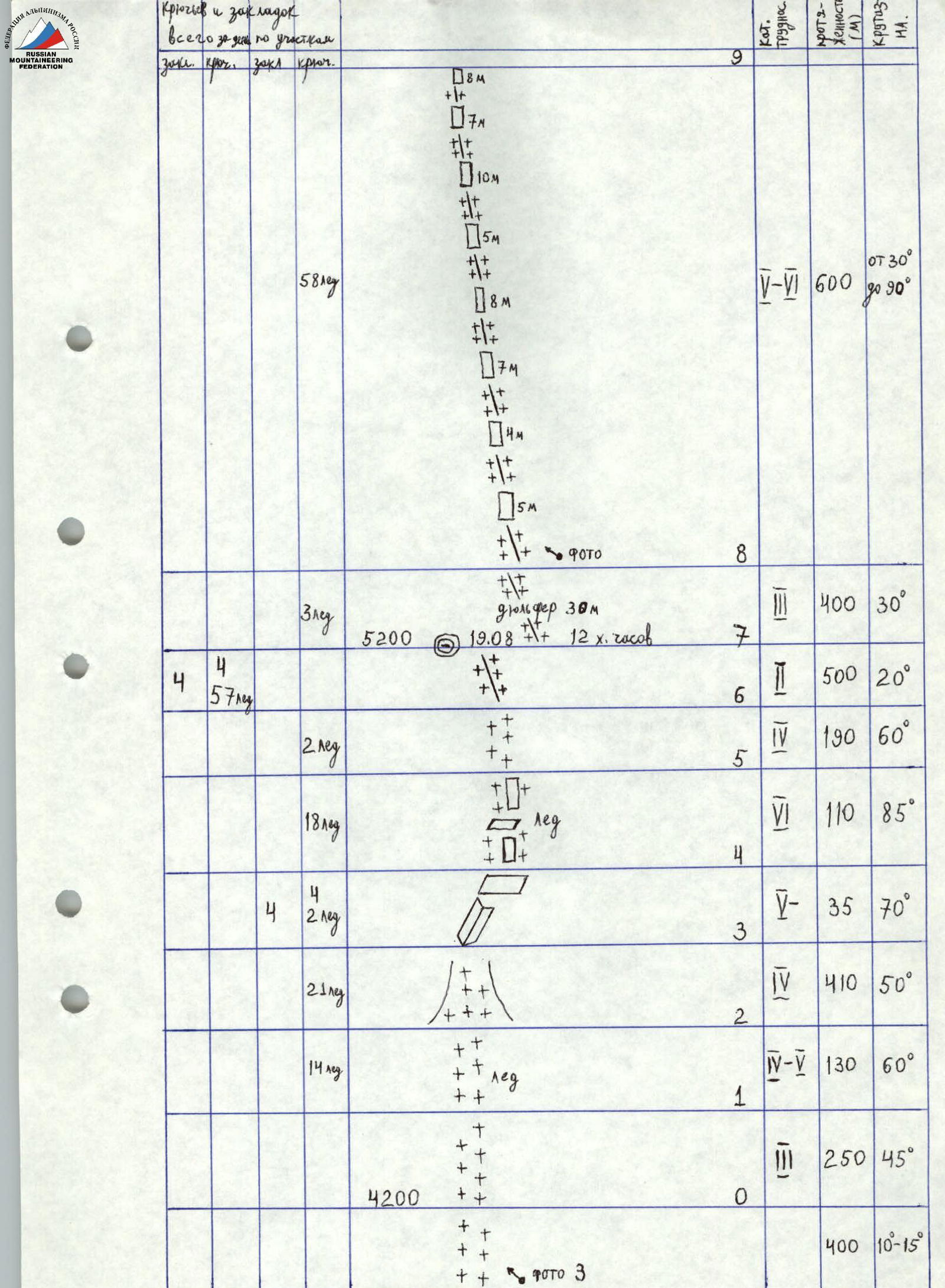
| Section # | Complexity Category | Length (m) | Steepness (°) | Notes |
|---|---|---|---|---|
| R0 | 3 | 250 | 45 | Altitude 4200 m |
| 400 | 10–15 | |||
| R1 | 4–5 | 130 | 60 | 14 ice screws |
| R2 | 4 | 410 | 50 | 21 ice screws |
| R3 | 5 | 35 | 70 | 4 pitons, 2 ice screws |
| R4 | 6 | 110 | 85 | 18 ice screws |
| R5 | 4 | 190 | 60 | 2 ice screws |
| R6 | 2 | 500 | 20 | 57 ice screws |
| R7 | 3 | 400 | 30 | August 19, 12 hours |
| R8 | 5–6 | 600 | 30–90 | 58 ice screws |
| R9 | 5 | 45 | 70 | 3 pitons, 1 ice screw |
| R10 | 2 | 80 | 30 | 4 pitons, 62 ice screws |
| R11 | 4 | 150 | 55 | August 20, 10 hours 30 minutes |
| R12 | 5+ | 80 | 80 | 16 ice screws, 20 ice screws, 30 m |
| R13 | 3 | 40 | 35 | 26 ice screws |
| R14 | 3 | 300 | 40 | Altitude 6300 m, August 21–23, 5 hours |
| R15 | 4–5 | 80 | 60 | 5 ice screws, 10 m |
| R16 | 2 | 300 | 45 | |
| R17 | 3 | 150 | 40 | |
| R18 | 3 | 700 | Altitude 6744 m, Peak Neru | |
| R19 | 4 | 300 | 8 ice screws, rappel 45 m | |
| R20 | 1 | 1000 | 13 ice screws | |
| R21 | 1–2 | 1800 | Altitude 6700 m, August 24, 10 hours | |
| R22 | 4–5 | 100 | Altitude 6800 m, August 25, 2 hours | |
| R23 | 3 | 800 | 6 ice screws | |
| R24 | 1–2 | 1800 | ||
| R25 | Altitude 6918 m, August 26 |
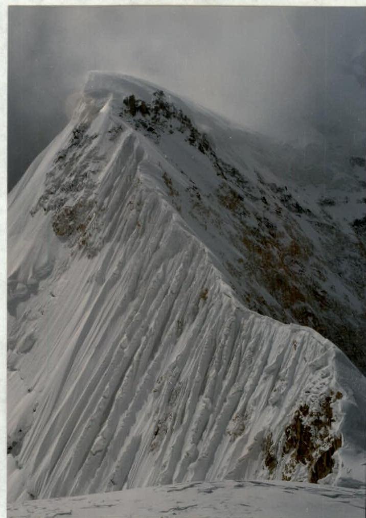 PHOTO #6. "Wavy ridge" (section R8–R9).
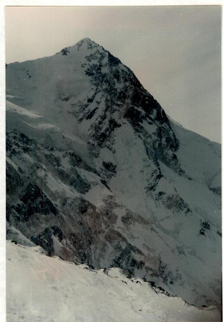 PHOTO #7. Peak Neru. Taken from the northern slope of Western Pobeda at an altitude of 5900 m.