
Russian Championship in Alpinism High-Altitude Technical Class 2018
Report
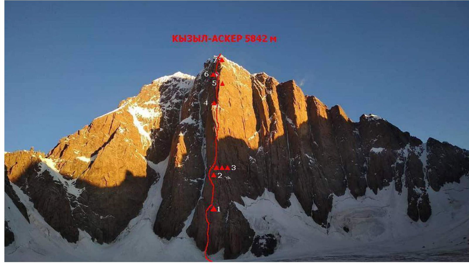
On ascending peak Kyzyl-Asker via the central spur of the southeast wall — "Franco-Belgian" variant. By the team from St. Petersburg. 2nd ascent. Proposed 6B category of complexity. From July 25 to August 3, 2018.
Team coach: Timoshenko T.I.
Team leader: Nagaev R.R. Team members:
- Matinyan A.A.
- Trikozov V.M.
St. Petersburg, 2018
Ascent Details
| № | General Information | |
|---|---|---|
| 1.1 | Full name, sports rank of the team leader | Nagaev R.R., Master of Sports |
| 1.2 | Full name, sports rank of the team members | Matinyan A.A., Candidate for Master of Sports Trikozov V.M., Candidate for Master of Sports |
| 1.3 | Full name of the coach | Timoshenko T.I. |
| 1.4 | Organization | FAS |
| 2. | Characteristics of the ascent object | |
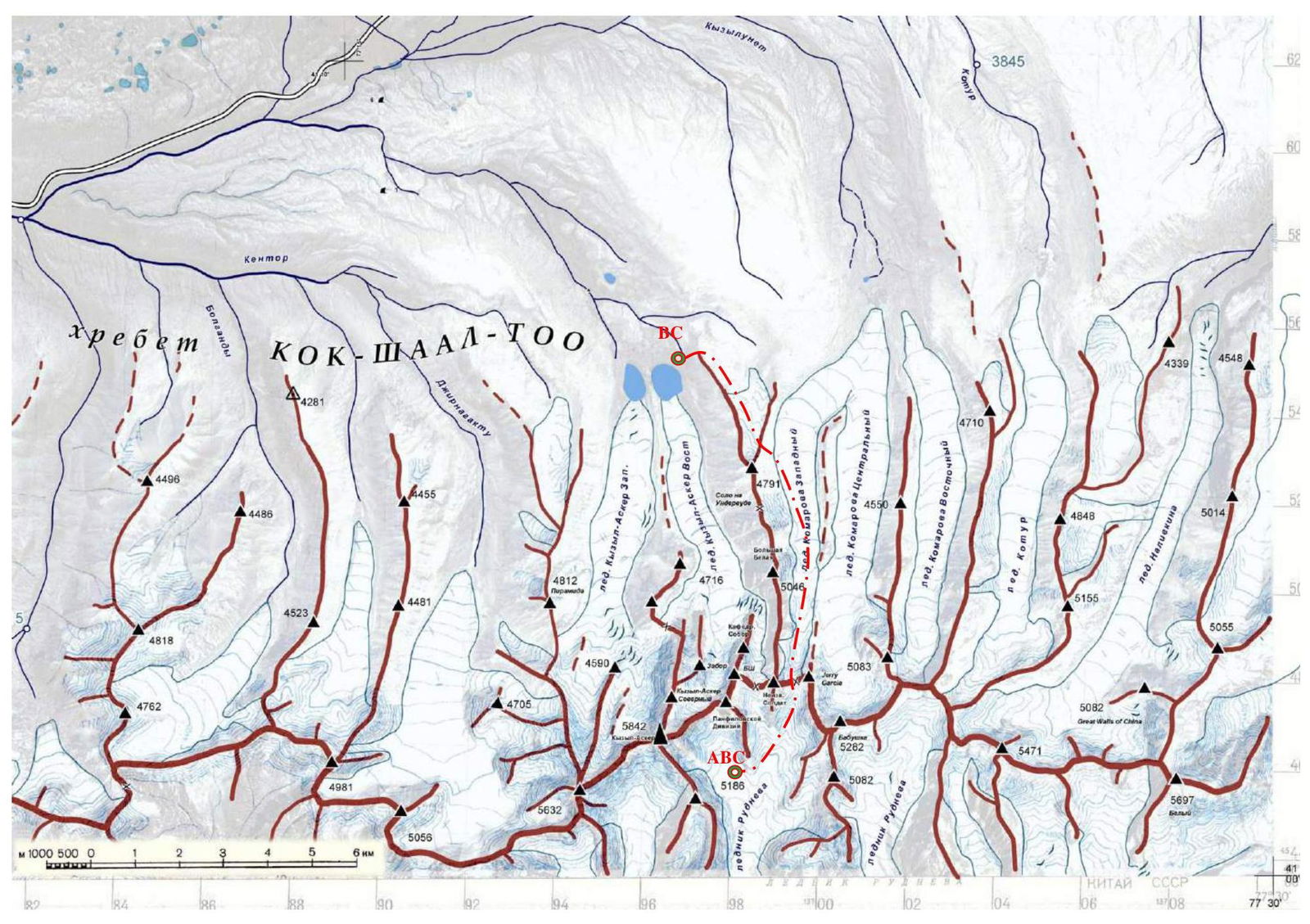
| 2.1 | Region | Tian Shan |
| 2.2 | Valley | Western Kok-Shaal-Too |
| 2.3 | Section number according to the 2013 classification table | 7.5 |
| 2.4 | Name and height of the peak | Kyzyl-Ask., 5842 m |
| 3. | Characteristics of the route | |
| 3.1 | Name of the route | variant — via the central spur of the southeast wall ("Franco-Belgian") |
| 3.2 | Proposed category of complexity | 6B |
| 3.3 | Degree of route exploration | 2nd ascent |
| 3.4 | Relief characteristics of the route | combined |
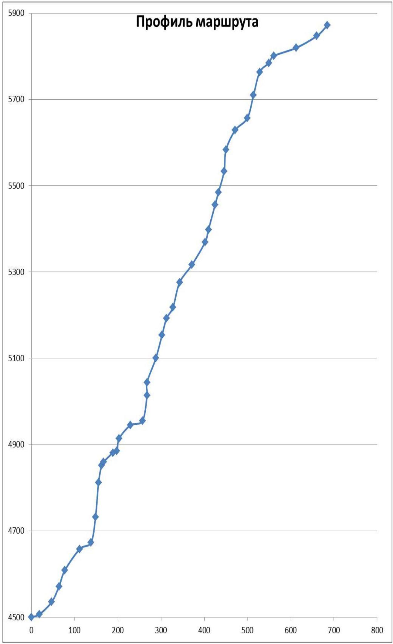
| 3.5 | Elevation gain on the route (altimeter data) | 1397 m |
| 3.6 | Route length | 1620 m, wall section: 1475 m |
| 3.7 | Technical elements of the route (total length of sections of varying complexity) | I — 0 m. II — ice 20 m. III — ice/rock/combination 170 m. IV — ice/rock/combination 190 m. V — rock/combination 560 m. VI — rock/combination 680 m. D rappel (on descent) – 24 ropes about 1200 m |
| 3.8 | Average slope of the route, ° | 60 |
| 3.9 | Average slope of the main part of the route, ° | 71 |
| 3.10 | Descent from the peak | Following the ascent route to R15, then down the orographically right side of a wide couloir onto the glacier, down the glacier under the bergschrund, then traverse on foot to the east about 500 m and down. |
| 3.11 | Additional route characteristics | Many ledges have ice, the wall has numerous icicles, snow melts actively in the lower half of the route — small streams (waterfalls) on the route line. Crevasses are often blind. The rock is strong, granitoid. The lower part of the route to R6 is exposed to rockfall, and there are loose flakes on the wall section. |
| 4. | Characteristics of the team's actions | |
| 4.1 | Time in motion | To the summit 76 hours, 10 days (2 days of bad weather) Descent 14 hours, 2 days |
| 4.2 | Overnight stays | 1 — lying, platform; 2–5 — lying, ice-cut ledge 6–8 — semi-reclining, ice-cut ledge 9 — lying, ice-cut platform |
| 4.3 | Entry onto the route | 9:00, July 25, 2018 |
| 4.4 | Reaching the summit | 14:30, August 3, 2018 |
| 4.5 | Return to base camp | 5:00, August 5, 2018 |
| 5. | Characteristics of weather conditions | |
| Date | Cloud cover (visibility) | Precipitation |
| 25.07 | Sunny (unlimited) | - |
| 26.07 | Variable cloud cover (unlimited) | Snow in the second half |
| 27.07 | Sunny (unlimited) | - |
| 28.07 | Variable cloud cover (50 – unlimited) | Wet snow after 10:00 |
| 29.07 | Variable cloud cover (50 – unlimited) | Wet snow after 10:00 |
| 30.07 | Variable cloud cover (50 – unlimited) | Snow in the second half |
| 31.07 | Sunny (unlimited) | - |
| 1.08 | Variable cloud cover (30 – unlimited) | Snow in the second half |
| 2.08 | Variable cloud cover (30 – unlimited) | Snow in the second half |
| 3.08 | Sunny | - |
| 6. | Responsible for the report | |
| 6.1 | Full name, e-mail | Nagaev R.R., nagaevrust@mail.ru |
Area Overview
This region has many peaks around 6000 m. The most interesting among them are:
- peak Kyzyl-Asker (5842 m)
- peak Krylya Sovetov (5800 m)
- peak Shmidta (5954 m, unclimbed)
- peak Dankova (5982 m)
- peak Chon-Turasy or Joldash (5729 m)
- peak Alpinist (5641 m)
- peak Sergey Korolyov (5816 m)
The area is characterized by a combination of typical Alpine forms (many vertical rock walls with a height difference of about 1.5–2 km) and extensive glaciation, second only to the peak Pobeda region in Tian Shan. The entire area, including lowlands, is a permafrost zone. Often, marshy areas are found up to elevations of 4000 m.
The snow line is at an altitude of about 4000–4500 m above sea level. River valleys have a high absolute height of about 3000–3500 m above sea level. The climate in the valley is harsh. The average monthly temperature in summer is about 5–8 °C, with unstable weather.
Kyzyl-Asker translates from Kyrgyz as "Red Army Man." The first ascent of this mountain was made by K. Valeev's team in 1985. The legendary team ascended the mountain via the northwest wall during the USSR Championship in Alpinism in the high-altitude technical class and ultimately ranked 4th.
There are reports of 7 ascents to this peak:
- 1985 — first ascent by Valeev's team
- 2004 — Pete Benson and Matt Halls ascended via a new route, starting from the south through a couloir between Kyzyl-Asker and peak Panfilovskoy Divizii
- 2007 — the team Odintsov–Ruchkin–Mikhailov ascended the most beautiful line to the summit via the central spur of the southeast wall
- 2013 — repetition of the route via the central spur of the southeast wall by a Franco-Belgian team
- 2014 — first ascent by a Moscow team via the center of the southeast wall
- 2014 — first ascent by an Ecuadorian team via the second spur of the southeast wall
- 2016 — a Krasnoyarsk team ascended via the center of the southeast wall, "Kopyo."
Additionally, there are reports of at least 6 failed attempts at first ascents.
Technical photo with the ascent route thread
Tactical Team Actions
The base camp was established at an altitude of 3850 m, at the foot of the Kyzyl-Asker East glacier. Nearby peaks/hills are above 4000 m. During acclimatization, a reconnaissance was conducted for a descent variant onto the Kyzyl-Asker East glacier and an optimal path to the Komarov West glacier.
After a rest day — transition to the Komarov West glacier, a closed glacier, movement in groups with crampons in snowshoes. Overnight stay in the vicinity of peak Okhrovaya стена.
On the second day of the approach:
- part of the cargo was transferred to the Rudeva glacier to the intended location of the assault camp.
- overnight stay on the pass between peaks Neizvestnyy Soldat and Jerry Garcia, the pass height according to the altimeter was 4950 m.
Third day:
- approach under the peak,
- observation,
- establishment of the assault camp on the Rudeva glacier, height according to the altimeter 4500 m.
During the ascent, the team used 60-meter ropes, 4 in total: 2 static and 2 dynamic. Ice tools, crampons, and ice screws were actively used on the route (lower part and top), as well as rock climbing equipment: anchor hooks, fifi hooks, nuts, and friends.
All places for the tent on the route were cut into the ice, except for the first overnight stay, where the platform was leveled with stones.
Descent was made following the ascent route to the location of the third overnight stay (R15), then down the orographically right side of a wide couloir, crossing the couloir in the lower part (exposed to rockfall), then onto the glacier below the bergschrund, traverse under the bergschrund to the northeast to the nearest spur. Then down. The descent following the ascent route from R15 is exposed to rockfall regardless of the route's condition.
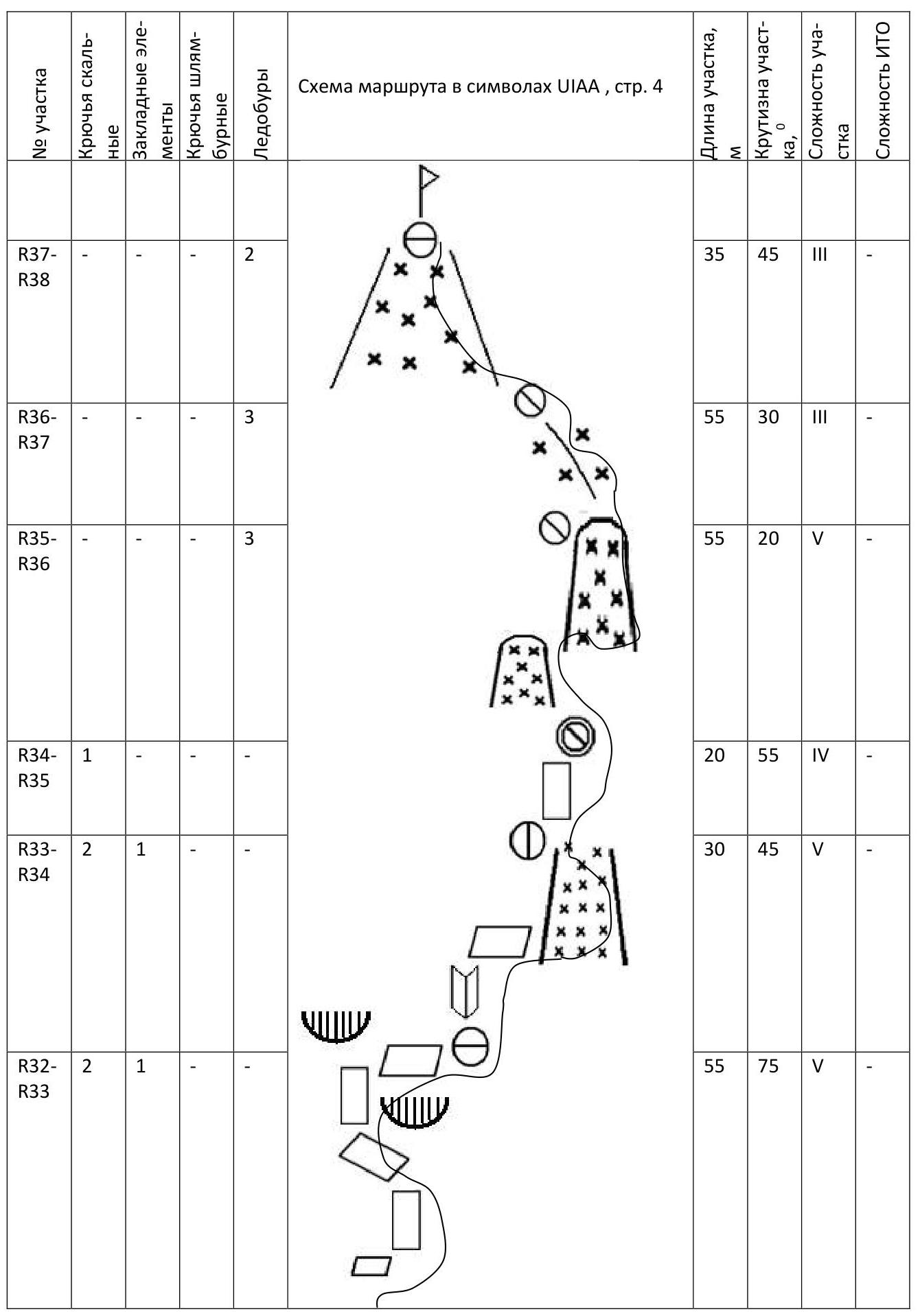
UIAA symbol route diagram
| Section | Rock anchors | Placement elements | Drill anchors | Ice screws | Section length, m | Section steepness, ° | Section complexity | Complexity of artificial aids |
|---|---|---|---|---|---|---|---|---|
| R0–R1 | 3 | - | - | - | 20 | 20 | II | - |
| R1–R2 | 2 | 2 | - | 1 | 40 | 45 | III | - |
| R2–R3 | 5 | 5 | - | - | 40 | 65 | V | - |
| R3–R4 | 6 | 9 | - | - | 40 | 70 | VI | A0 |
| R4–R5 | 3 | 3 | - | - | 60 | 55 | IV | - |
| R5–R6 | 4 | 6 | - | - | 30 | 30 | III | - |
| R6–R7 | 5 | 4 | - | - | 60 | 80 | VI | A1 |
| R7–R8 | 4 | 2 | - | - | 80 | 85 | VI | A1 |
| R8–R9 | 4 | 2 | - | - | 40 | 80 | VI | A1 |
| R9–R10 | 3 | 1 | - | - | 10 | 60 | IV | - |
| R10–R11 | 3 | 3 | - | - | 30 | 45 | IV | - |
| R11–R12 | 2 | - | - | - | 10 | 20 | III | - |
| R12–R13 | 3 | - | - | 3 | 30 | 80 | VI | A1 |
| R13–R14 | 3 | - | - | 3 | 40 | 50 | V | - |
| R14–R15 | 2 | 1 | - | 3 | 30 | 20 | V | - |
| R15–R16 | 5 | 5 | - | - | 60 | 80 | VI | A2 |
| R16–R17 | 4 | 2 | - | - | 30 | 90 | VI | A2 |
| R17–R18 | 3 | 1 | - | - | 60 | 70 | VI | - |
| R18–R19 | 3 | 2 | - | - | 55 | 75 | V | - |
| R19–R20 | 3 | - | - | - | 40 | 75 | V | - |
| R20–R21 | 2 | - | - | - | 30 | 60 | IV | - |
| R21–R22 | 3 | 3 | - | - | 60 | 75 | VI | A0 |
| R22–R23 | 2 | - | - | - | 50 | 55 | V | - |
| R23–R24 | - | - | - | 4 | 60 | 60 | V | - |
| R24–R25 | 3 | 1 | - | - | 30 | 75 | VI | A1 |
| R25–R26 | 1 | 3 | - | - | 60 | 75 | VI | A1 |
| R26–R27 | 2 | - | - | - | 30 | 75 | VI | A0 |
| R27–R28 | 3 | 1 | - | - | 50 | 75 | VI | A0 |
| R28–R29 | 4 | 2 | - | - | 50 | 85 | VI | A2 |
| R29–R30 | 2 | 1 | - | - | 50 | 65 | V | - |
| R30–R31 | 1 | - | - | 2 | 40 | 45 | IV | - |
| R31–R32 | 3 | - | - | - | 55 | 75 | V | - |
| R32–R33 | 2 | 1 | - | - | 55 | 75 | V | - |
| R33–R34 | 2 | 1 | - | - | 30 | 45 | V | - |
| R34–R35 | 1 | - | - | - | 20 | 55 | IV | - |
| R35–R36 | - | - | - | 3 | 55 | 20 | V | - |
| R36–R37 | - | - | - | 3 | 55 | 30 | III | - |
| R37–R38 | - | - | - | 2 | 35 | 45 | III | - |
Route Description
The approach from the base camp at the foot of the Kyzyl-Asker East glacier takes 2 days. The approach from the assault camp to the start of the route via the glacier takes about an hour on a closed glacier. The guideline is the southern spur of Kyzyl-Asker; in the lower part, you can orient yourself by two sentinels standing one above the other.
R0–R1. The glacier ends 20 m before the rock with a bergschrund; we cross it in a group. Station on the rock. 20 m, 20°, II.
R1–R2. Then along the rock along the glacier. 40 m, 45°, III.
R2–R3. A system of internal corners and ledges. Station on a ledge before an internal corner, from which it was heavily snowing; had to climb to the right along the wall. 40 m, 65°, V.
R3–R4. Wall with a crack under artificial aids. 40 m, 70°, VI, A0 (photo 2).
R4–R5. After the wall, we enter a couloir. Station on a rock on anchors at the exit from the couloir. 60 m, 55°, IV.
R5–R6. Traverse along slabs to the right. Station on a ledge — overnight stay location. 30 m, 30°, III.
R6–R7. Above the ledge is a vertical wall with several small cornices. 60 m, 80°, VI, A1 (photo 3).
R7–R8. Then we move up the vertical wall and turn left along an oblique ledge. At the end of the oblique ledge is a station on the wall. 80 m, 85°, VI, A1 (photos 4, 5).
R8–R9. Vertical wall with a system of cracks. Station on a ledge at the beginning of an internal corner. 40 m, 80°, VI, A1 (photo 6).
R9–R10. Move up along an inclined slab; station at its end. 10 m, 60°, IV.
R10–R11. Along "goat's heads," shifting to the right, station on anchor hooks before a snow bridge. Just below the station — overnight stay; had to cut ice. 30 m, 45°, IV.
R11–R12. Move along the snow bridge towards the wall. 10 m, 20°, III.
R12–R13. After the bridge, up along a slightly overhanging wall. 30 m, 80°, VI, A1 (photo 8).
R13–R14. The wall ends with a flattening. Move straight along inclined slabs, shifting to the left. The slabs end with an edge. 40 m, 50°, V (photo 8).
R14–R15. Then head along the edge up to a saddle and rappel to the lower saddle. Overnight stay location to the left of the saddle; had to cut ice. 30 m, 20°, V.
R15–R16. Up along an internal corner, which turns into another internal corner. The corner turns into a slab, on which is a station. 60 m, 80°, VI, A2.
R16–R17. Along a wall with a vertical crack, move to a pendulum point (two anchors) and make a pendulum to the right behind the ridge's bend. Station on placement elements on the bend. 30 m, 90°, VI, A2 (photo 9).
R17–R18. Climb up along the rib and shift to the right onto a slab with a crack and move up. 60 m, 70°, VI (photo 10).
R18–R19. Move up along an internal corner. Station at the end of the internal corner on a ledge. 55 m, 75°, V.
R19–R20. Move up along an icy internal corner. 40 m, 75°, V.
R20–R21. Then a small traverse to the right onto an inclined slab to the beginning of an internal corner. 30 m, 60°, IV.
R21–R22. Climb up along an internal corner to the beginning of a snow couloir. Station on a ledge before the couloir. 60 m, 75°, VI, A0.
R22–R23. Move up along a snowy couloir. At the end of the couloir is a station on the wall on anchor hooks. 50 m, 55°, V.
R23–R24. From the couloir, shift to the right and up, exit onto a snowy slope, along which we climb onto a "good ledge," which turned out to be an ice knife. Cut a ledge for overnight stay in the ice. 60 m, 60°, V.
R24–R25. Then half a rope up along the wall with a few cracks under overhanging cornices. Station on the wall under a cornice. 30 m, 75°, VI, A1.
R25–R26. Along the wall to the left up between two cornices, then along a vertical wall with a system of cracks. 60 m, 75°, VI, A1 (photos 11, 12).
R26–R27. Then up along a vertical slab 30 m. Station on anchor hooks; from it, rappel to the right down 20 m to a ledge for overnight stay. Cut a ledge in the ice; it turned out to be only sitting. From the station 30 m, 75°, VI, A0 (photo 13).
R27–R28. Along a system of slabs up and to the left. Station on anchor hooks. 50 m, 75°, VI, A0.
R28–R29. Then to the left and up through a system of overhanging cornices. Station to the left of the "hourglass." 50 m, 85°, VI, A2.
R29–R30. Along a snowy internal corner. Station on placement elements at the end of the internal corner. 50 m, 65°, V.
R30–R31. To the left up along a snowy slope to the beginning of the wall. Station on ice screws. Overnight stay on the station; cut a ledge in the ice. 40 m, 45°, IV (photo 14).
R31–R32. Climb up along a wall with poor terrain and blind cracks, shifting to the left. Station at the beginning of an internal corner. 55 m, 75°, V (photo 15).
R32–R33. The internal corner ends with rock blocks, which we bypassed first to the right and then to the left, climbed onto a ledge, on which is a station. 55 m, 75°, V.
R33–R34. 5 meters up along an internal corner, then to the right onto a snowy slope, along which another 25 m to rocks, on which is a station. 30 m, 45°, V.
R34–R35. 20 m to the right and up along a slab to the exit onto a ridge. At the exit onto the ridge is a station and overnight stay. Had to cut a ledge for overnight stay as well. From this overnight stay, the summit is visible. 20 m, 55°, IV.
R35–R36. Cross from our ridge to the neighboring right ridge; to do this, first descend along the ridge and then climb. Station on ice screws. 55 m, 20°, V.
R36–R37. From the station to the right along the ridge towards the summit. 55 m, 30°, III.
R37–R38. Then up along a snowy slope with an exit onto a ridge with a rock wall, on which is a tin with a summit note. 35 m, 45°, III.
Photo from the summit; as the battery charge was not enough, a note from the St. Petersburg team, consisting of E. Murin and I. Penyaev, was photographed (photo and original note are attached).
Descent was made following the ascent route to the location of the third overnight stay (R15), then down the orographically right side of a wide couloir, crossing the couloir in the lower part (exposed to rockfall), then onto the glacier below the bergschrund, traverse under the bergschrund to the northeast to the nearest spur. Then down.
The descent following the ascent route from R15 is exposed to rockfall regardless of the route's condition. Descent from the summit towards the Kyzyl-Asker glacier is avalanche-prone after heavy snowfalls.
Photo Illustrations
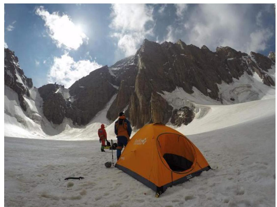
Photo 1. Assault camp
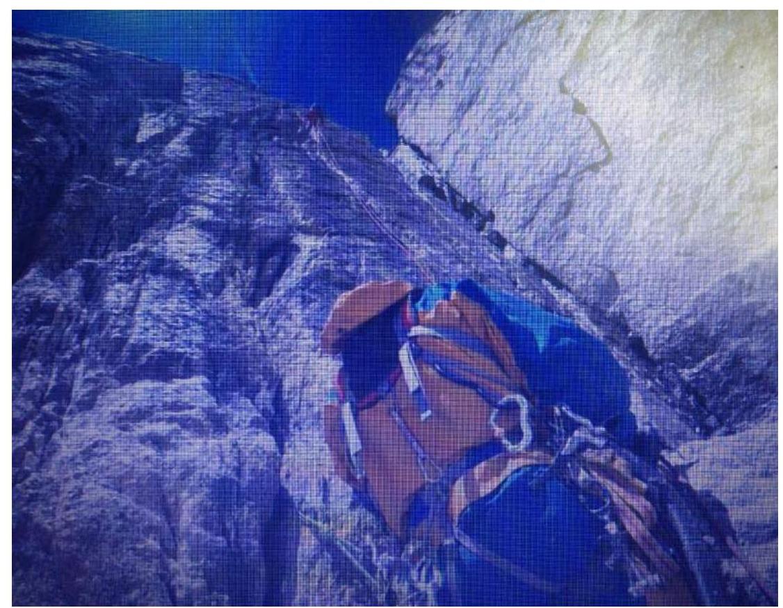
Photo 2. Section R3–R4
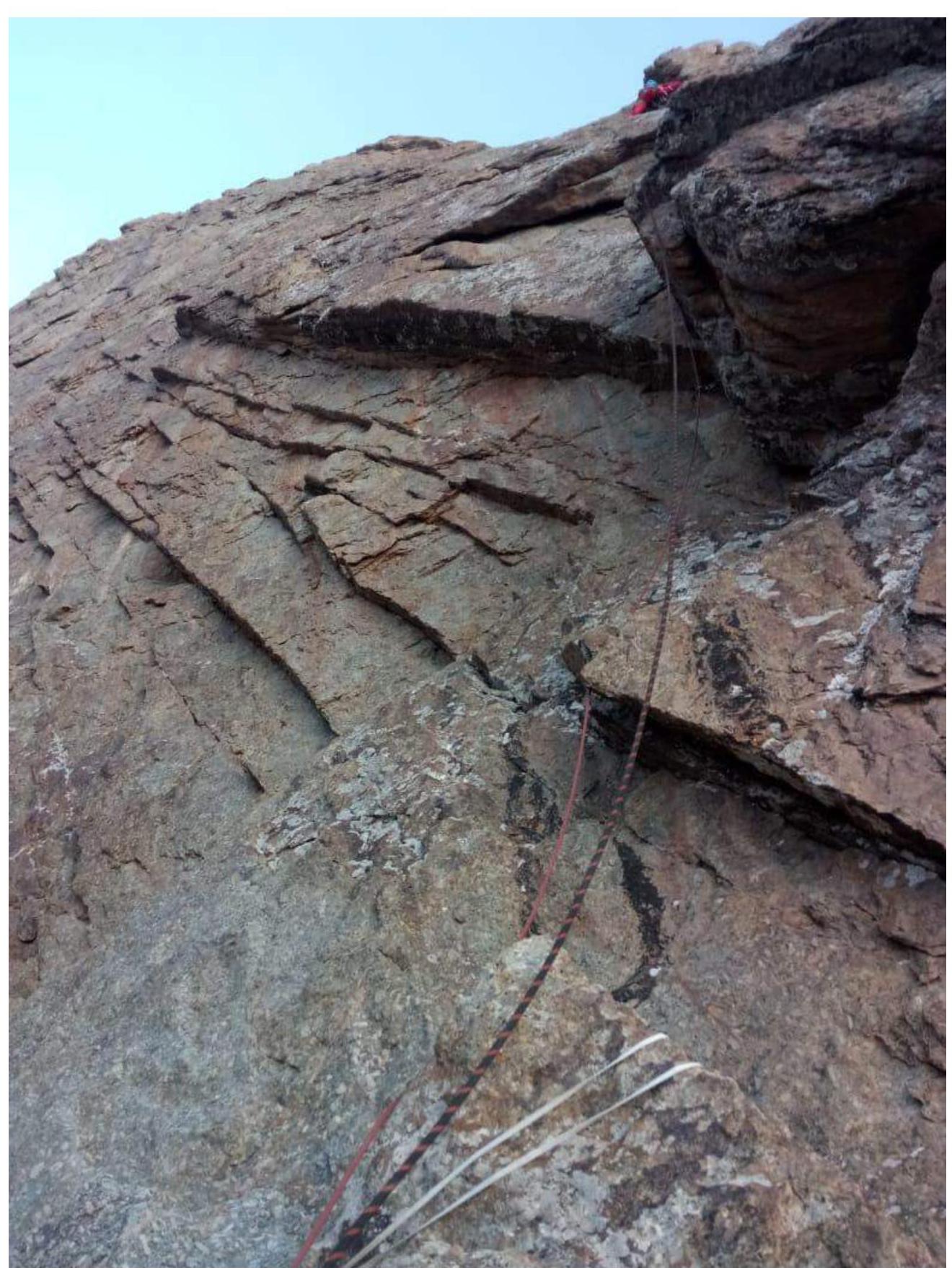
Photo 3. Section R6–R7

Photo 4. Section R7–R8
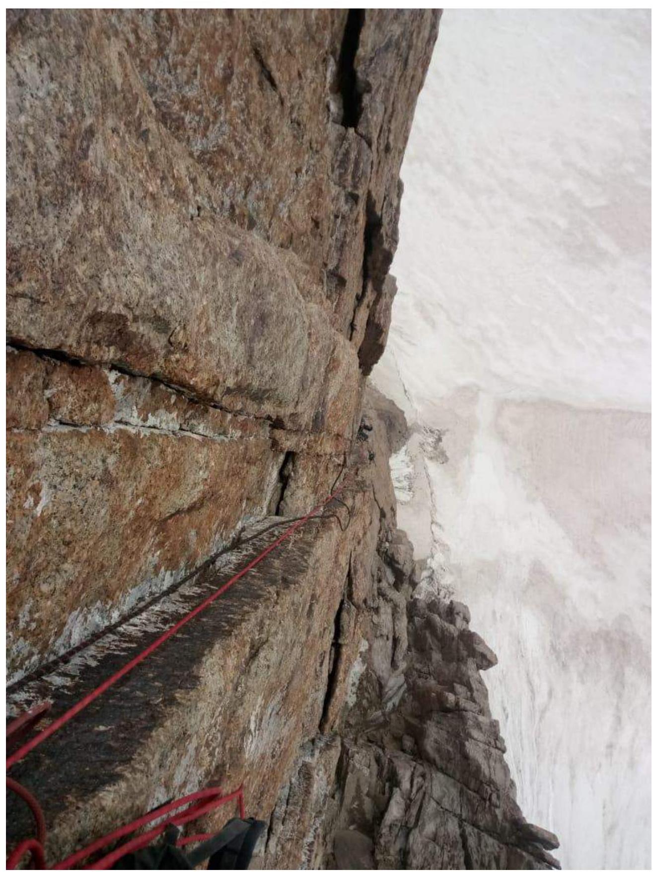
Photo 5. Section R7–R8
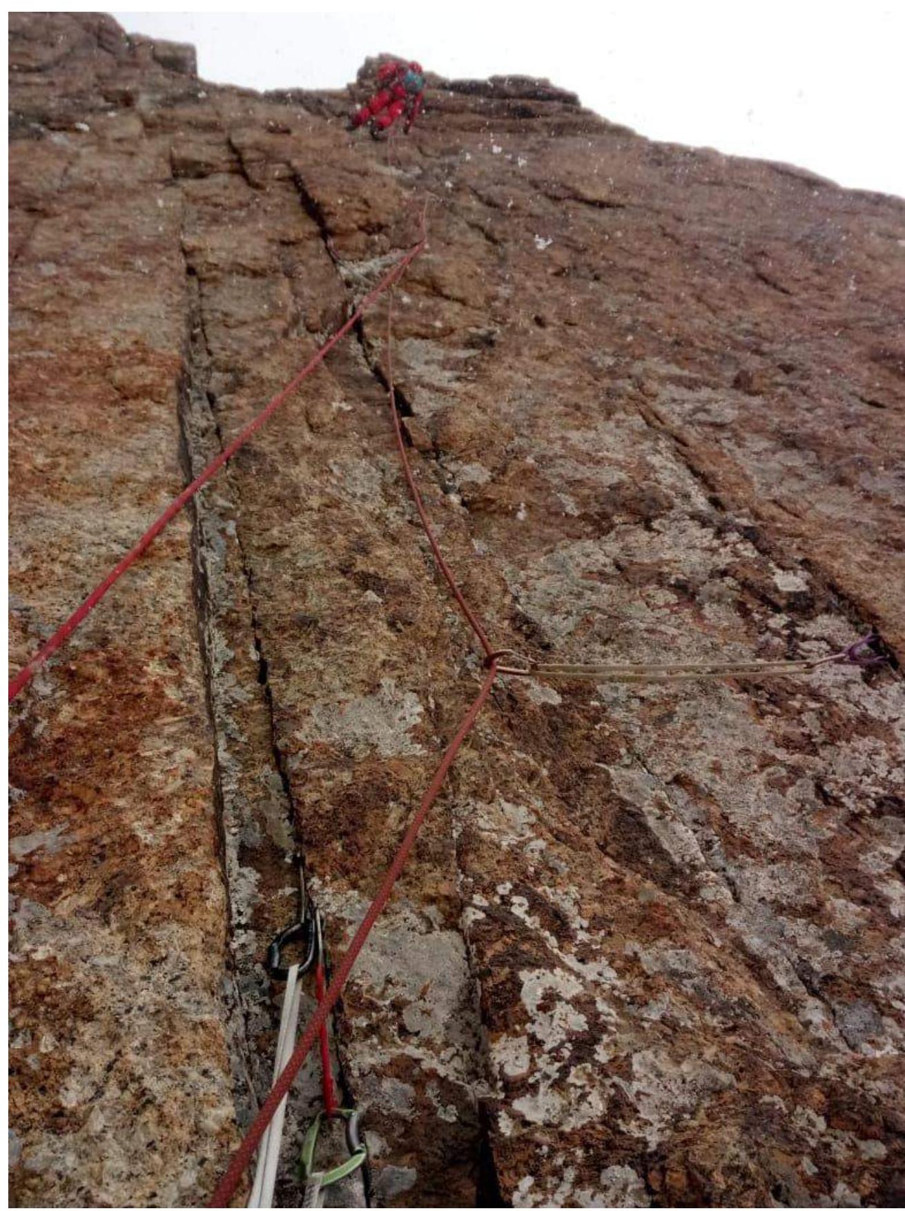
Photo 6. Section R8–R9
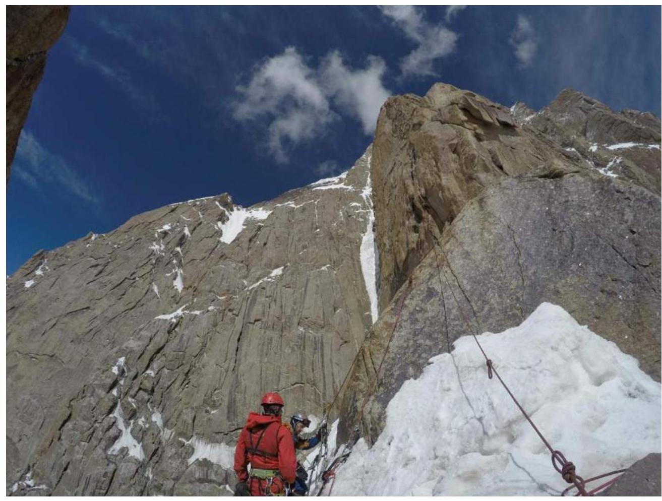
Photo 7. Station on R11
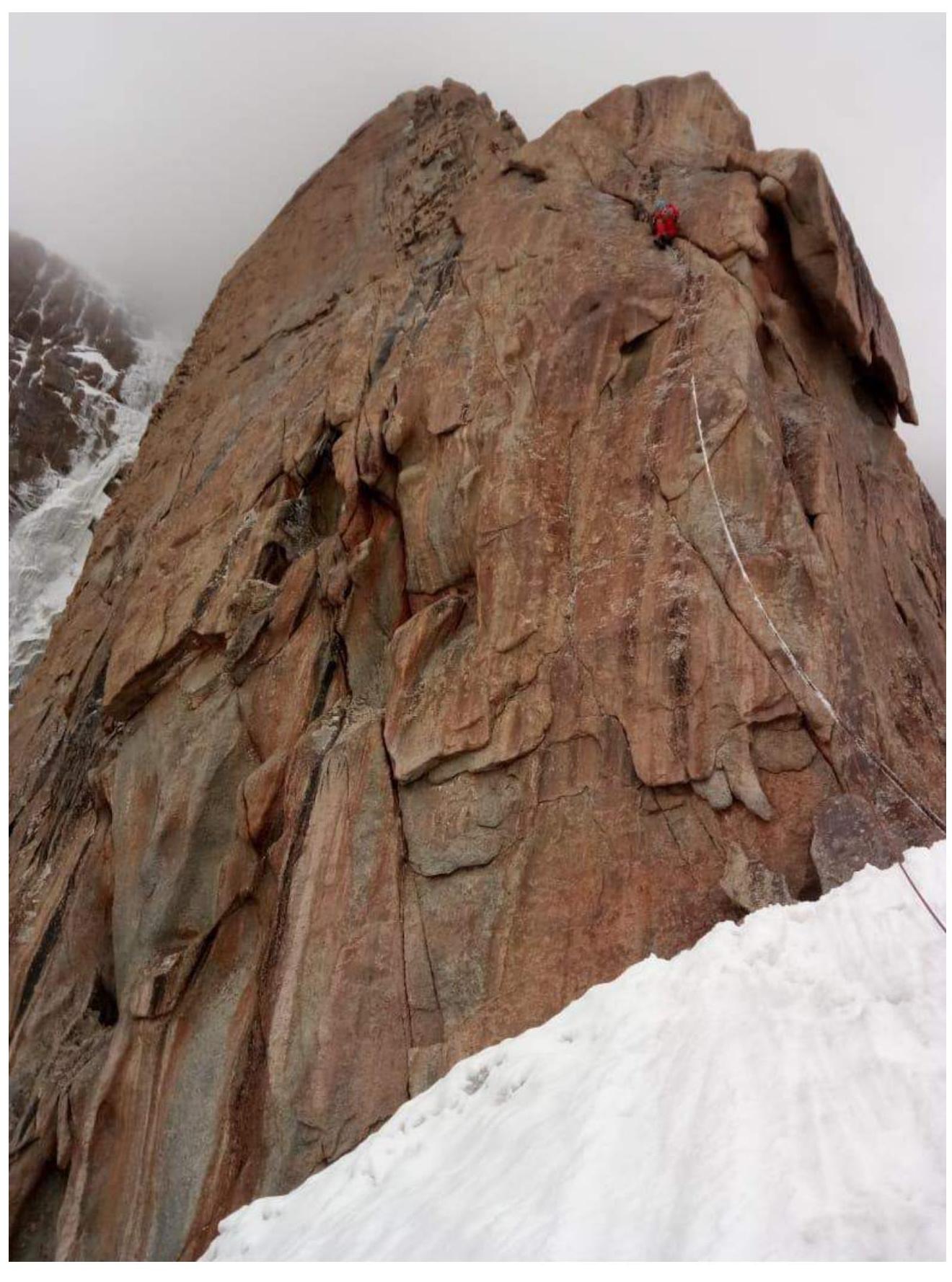
Photo 8. Section R12–R13
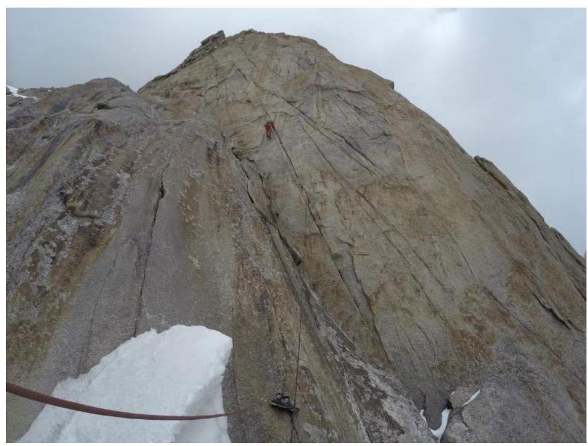
Photo 9. Section R16–R17. Artur at the pendulum point.
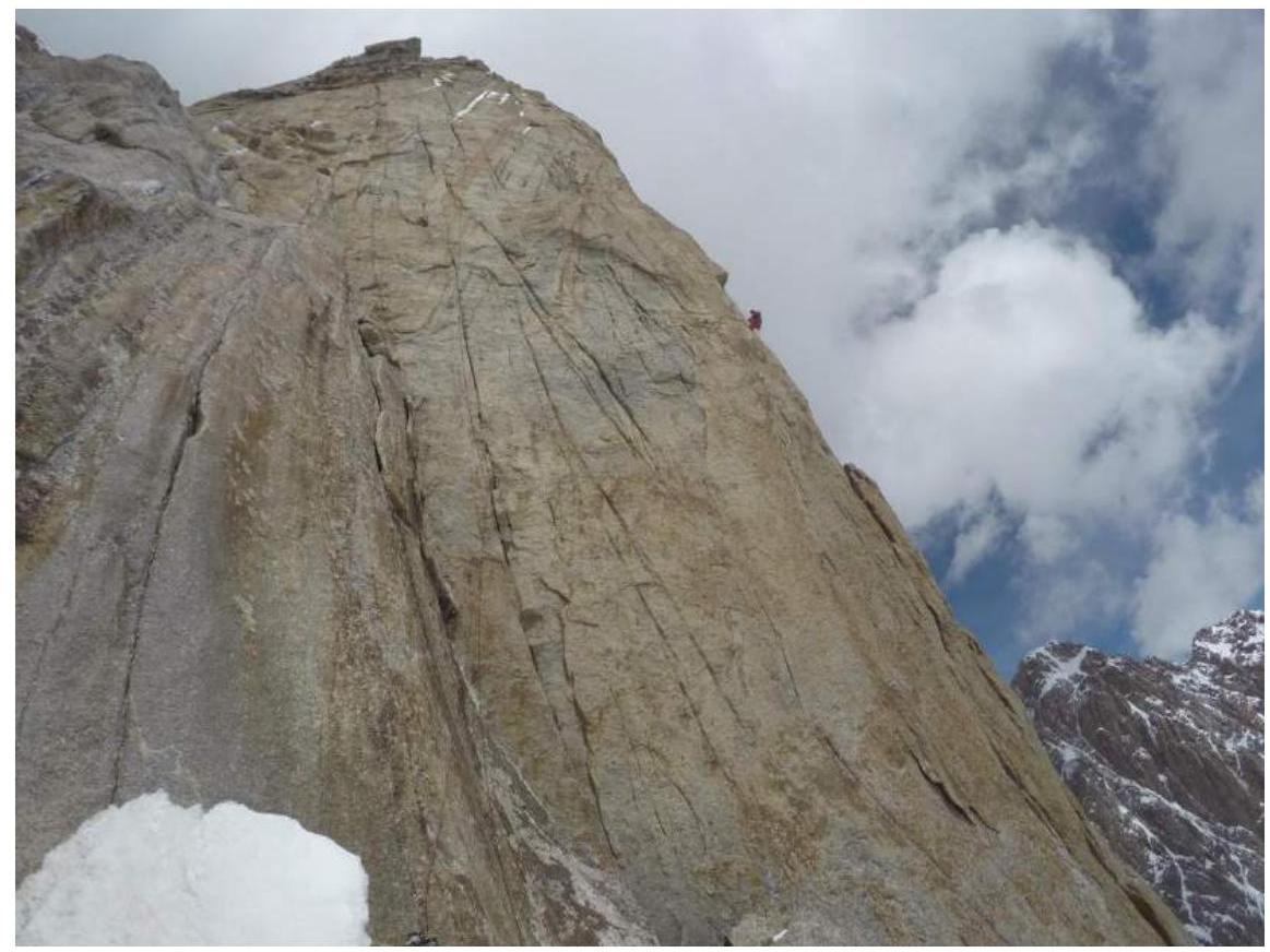
Photo 10. Station R17
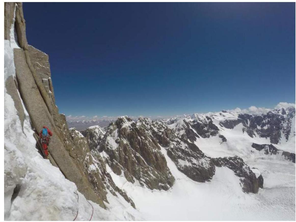
Photo 11. Beginning of section R25–R26
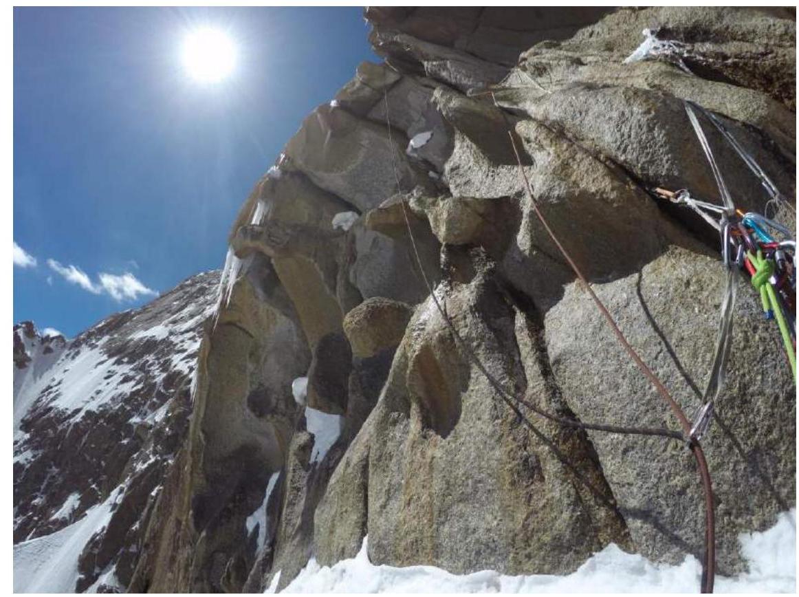
Photo 12. Station R26
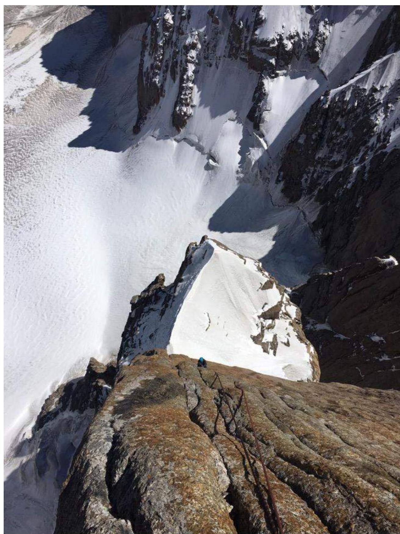
Photo 13. Section R26–R27
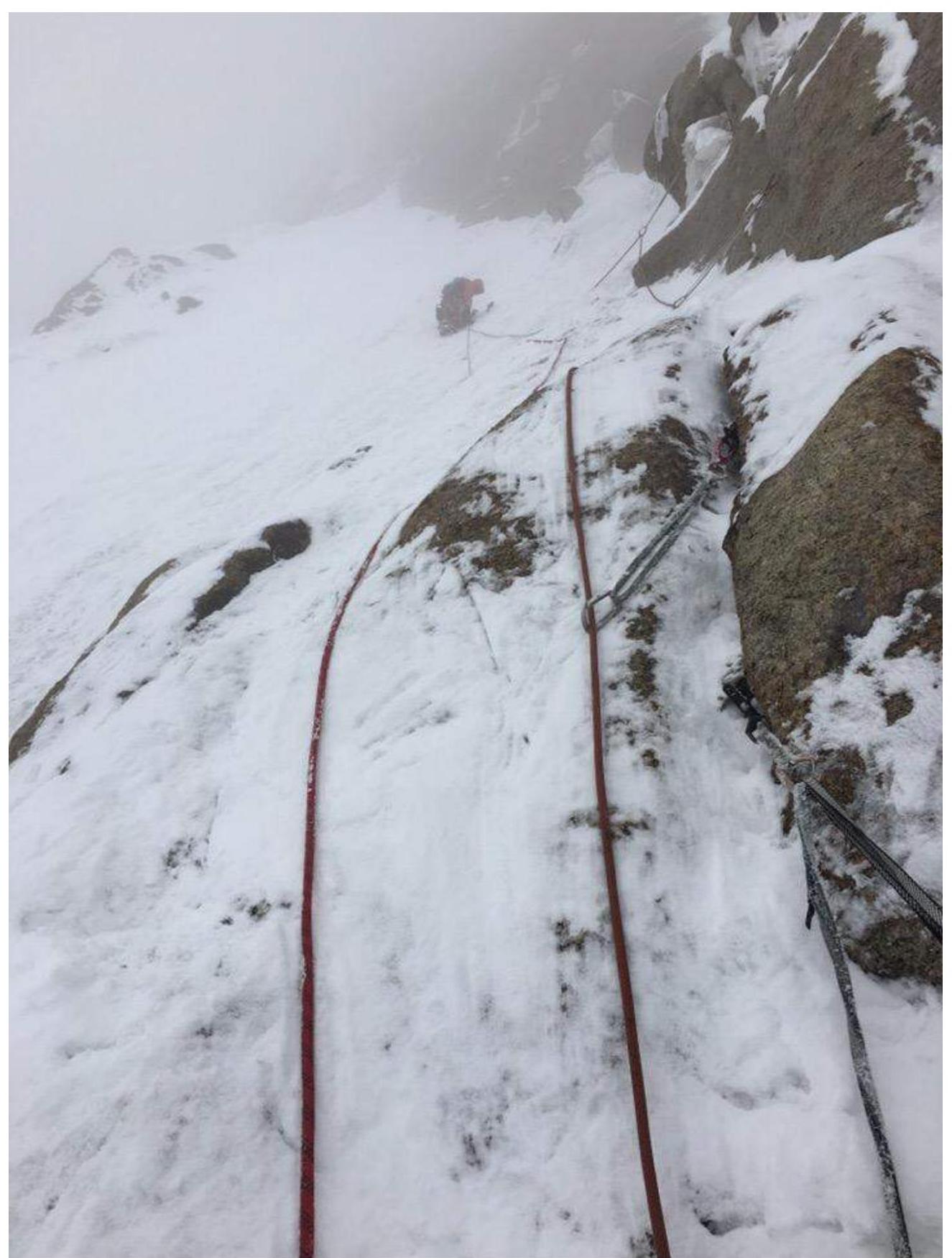
Photo 14. Section R30–R31
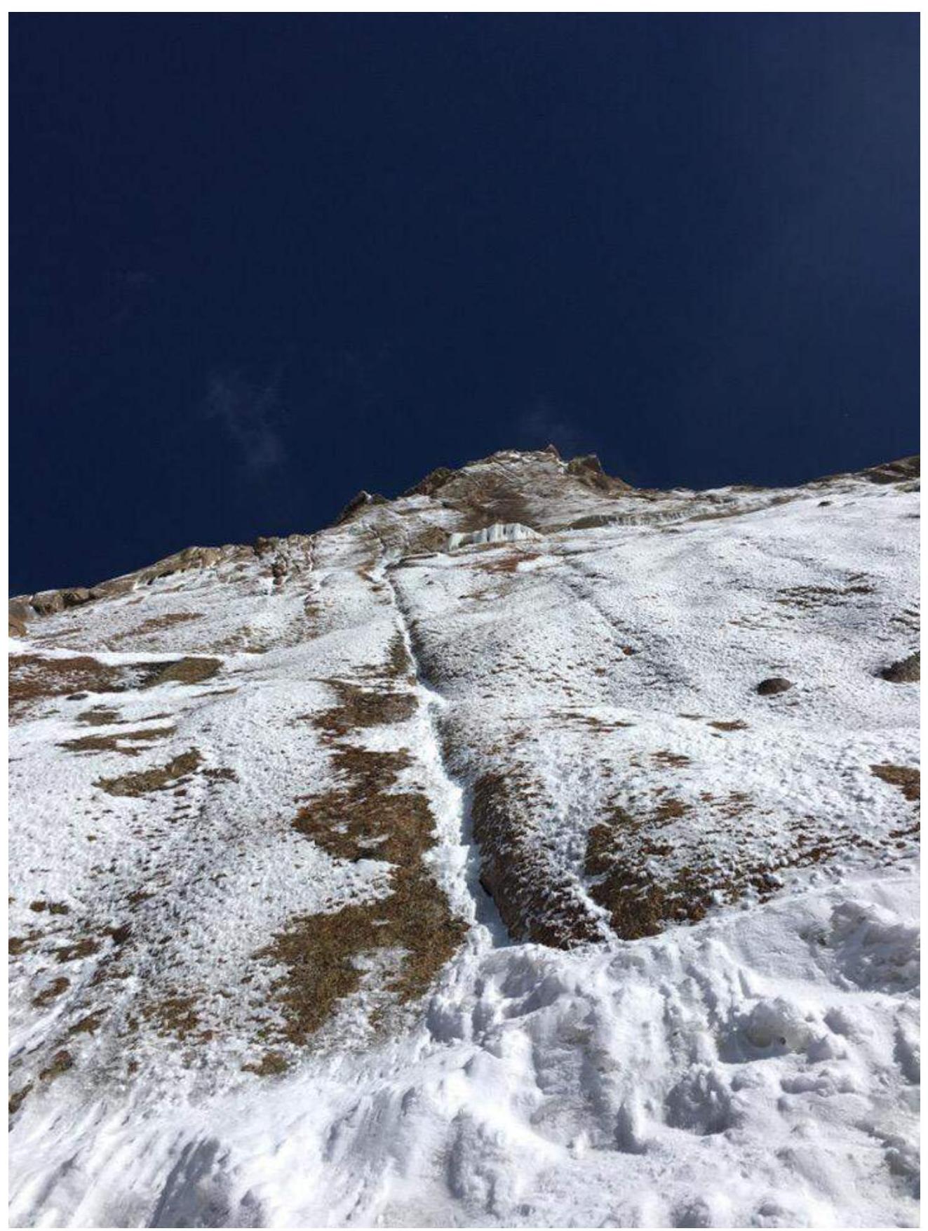
Photo 15. Section R31–R32
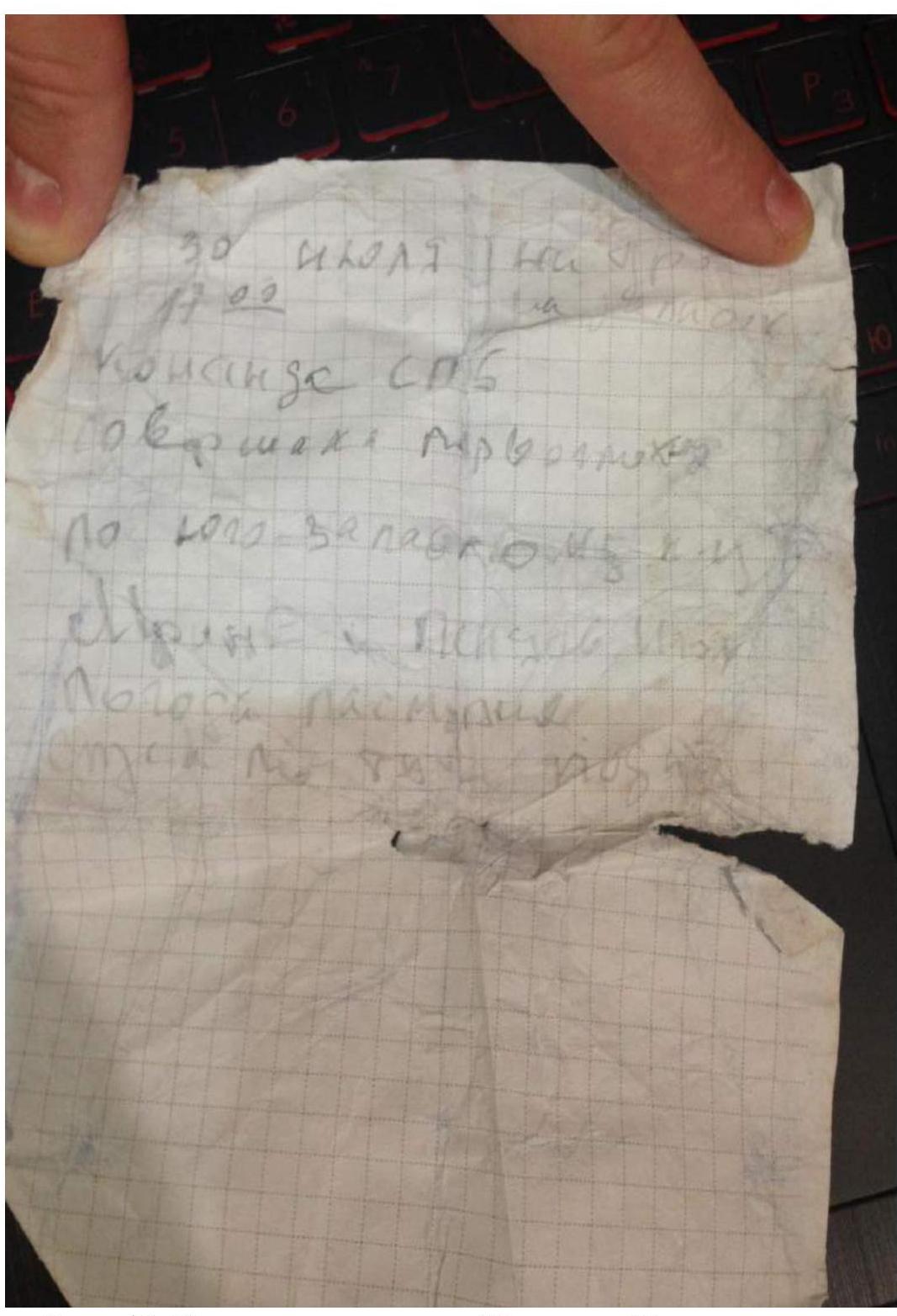
Photo 17. Summit note of Murin and Penyaev
Comments
Sign in to leave a comment