
Ascent Passport
- Class — high-altitude technical.
- Tian Shan, Western Kokshaal-Tau ridge, p. Kyzyl Asker.
- Peak Kyzyl Asker 5842 m, via the center of the northwest wall.
- Proposed — 6B category of complexity, first ascent.
- Height difference 1490 m, wall part 1170 m, wall part length 1280 m, average steepness of the wall part 69–71° 4350–4800 — 82° 4800–5400 — 73–76° 5400–5550 — 45–50°
- Pitons driven:
| Rock | Bolt | Placement elements | Ice |
|---|---|---|---|
| 144 | 25 | 166 | 16 |
| 29 | 8 | 90 |
of which at bivouacs: 8 4 7. Team's travel hours: 78 hours, 8 days. 8. Bivouacs: 1st — sitting, on a shelf carved in ice, 2 × 4 people in a tent; 2nd — sitting, on rock shelves, in tents with 5 and 3 people. 9. Leader: VALIEV Kazbek Shakimovich — Honored Master of Sports
team members:
- LUNYAKOV Grigory Evgenievich — Master of Sports
- MOISEEV Yuri Mikhailovich — Master of Sports
- SAMOILOV Sergey Georgievich — Candidate for Master of Sports
- SMIRNOV Vadim Anatolyevich — International Master of Sports
- SUVIGA Vladimir Ivanovich — Master of Sports
- SHAPOVALOV Valery Nikolaevich — Candidate for Master of Sports
- KHALITOV Zinnur Shagabutdinovich — Master of Sports
- Coach — ILYINSKY Ervand Tikhonovich — Honored Master of Sports, Honored Coach of the USSR.
- Exit to the route: August 11, 1985. Summit — August 18, return — August 18.
Glacier. Start of movement!
Finishing the ascent to the summit.
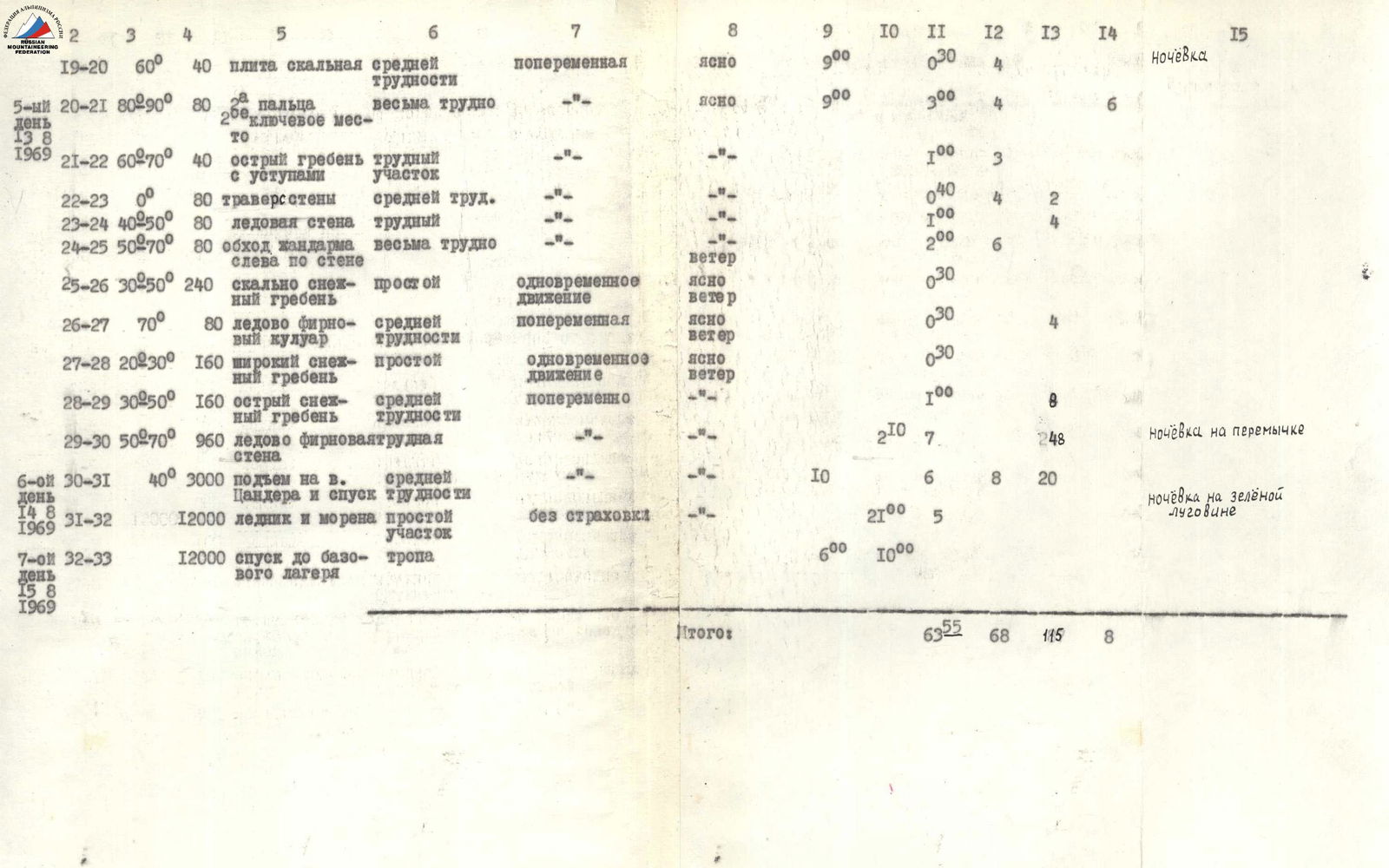
| Date | Sections covered | Average steepness | Length in the direction of movement in m | Terrain characteristics | Technical difficulties | Type of belay | Weather conditions | Departure time | Stop for bivouac | Travel hours | Rock pitons driven | Ice pitons driven | Bolt pitons driven | Notes |
|---|---|---|---|---|---|---|---|---|---|---|---|---|---|---|
| 1 | 2 | 3 | 4 | 5 | 6 | 7 | 8 | 9 | 10 | 11 | 12 | 13 | 14 | 15 |
| 1st day | R0–R1 | 15 | 12000 | from camp along the trail to the green meadow | clear | 13:00 | 17:00 | 4:00 | bivouac | |||||
| August 9, 1969 | ||||||||||||||
| 2nd day | R1–R2 | 20 | 6000 | moraine, glacier | simultaneous movement | clear | 6:00 | 3:00 | ||||||
| August 10, 1969 | R2–R3 | 30 | 160 | glacier | medium difficulty | alternate belay | clear, wind | 2:00 | 6 | |||||
| R3–R4 | 15 | 200 | glacier | easy section | simultaneous movement | wind | 1:00 | |||||||
| R4–R5 | 50 | 120 | glacier | medium difficulty | alternate belay | 2:00 | 6 | |||||||
| R5–R6 | 15 | 800 | glacier | easy section | simultaneous movement | 1:15 | ||||||||
| R6–R7 | 25 | 100 | glacier | easy section | simultaneous movement | clear | 0:30 | |||||||
| R7–R8 | 50 | 12 | rock wall | medium difficulty | alternate | 0:30 | 1 | |||||||
| R8–R9 | 15 | 800 | traverse of a steep snow-ice slope | medium difficulty | alternate via ice axe | 19:00 | 2:00 | bivouac | ||||||
| 3rd day | R9–R10 | 45 | 100 | snow-ice couloir | medium difficulty | alternate belay | clear | 7:00 | 1:30 | 2 | ||||
| August 11, 1969 | R10–R11 | 40 | 200 | rock-snow slope | medium difficulty | 2:50 | 2 | 5 | ||||||
| R11–R12 | 0 | 120 | snow-ice section | medium difficulty | 1:30 | 2 | ||||||||
| R12–R13 | 15 | 240 | snow shelf | easy | 14:00 | 2:00 | bivouac | |||||||
| 4th day | R13–R14 | 0 | 40 | traverse of wall and couloir | medium | ice axe, alternate | clear | 8:00 | 0:30 | 2 | 2 | |||
| August 12, 1969 | R14–R15 | 50–80 | 120 | ice couloir with exit via wall | difficult section | 2:00 | 10 | 4 | ||||||
| R15–R16 | 30 | 40 | ridge | medium | 0:30 | 2 | 1 | |||||||
| R16–R17 | 90 | 40 | vertical wall | difficult section | 1:00 | 4 | ||||||||
| R17–R18 | 90 | 80 | wall — key section | very difficult | 4:30 | 11 | 2 | 4 | ||||||
| R18–R19 | 70–80 | 120 | ice-rock couloir | difficult | 2:20 | 3 | 7 | 3 | ||||||
| 5th day | R19–R20 | 60° | 40 | rock slab | medium difficulty | alternate | clear | 9:00 | 0:30 | 4 | bivouac | |||
| August 13, 1969 | R20–R21 | 80–90° | 80 | "fingers" — key section | very difficult | clear | 9:00 | 3:00 | 6 | |||||
| R21–R22 | 60–70° | 40 | sharp ridge with ledges | difficult section | 1:00 | 3 | ||||||||
| R22–R23 | 0° | 80 | wall traverse | medium difficulty | 0:40 | 4 | 2 | |||||||
| R23–R24 | 40–50° | 80 | ice wall | difficult | 3:00 | 4 | ||||||||
| R24–R25 | 50–70° | 80 | bypassing a sentinel to the left via wall | very difficult | wind | 2:00 | 6 | |||||||
| 6th day | R25–R26 | 30–50° | 240 | rock-snow ridge | easy | simultaneous movement | clear, wind | 0:30 | 4 | |||||
| August 14, 1969 | R26–R27 | 70° | 80 | ice-firn couloir | medium difficulty | alternate | clear, wind | 0:30 | ||||||
| R27–R28 | 20–30° | 160 | wide snow ridge | easy | simultaneous movement | clear, wind | 0:30 | |||||||
| R28–R29 | 30–50° | 160 | sharp snow ridge | medium difficulty | alternate | 1:00 | 8 | |||||||
| R29–R30 | 50–70° | 960 | ice-firn wall | difficult | 2:10 | 7:00 | 48 | bivouac on a saddle | ||||||
| R30–R31 | 40° | 3000 | ascent to Tsander Peak and descent | medium difficulty | 10:00 | 6:00 | 8 | 20 | ||||||
| R31–R32 | 12000 | glacier and moraine | easy section | without belay | 21:00 | 5:00 | bivouac on a green meadow | |||||||
| 7th day | R32–R33 | 12000 | descent to base camp | trail | 6:00 | 10:00 | ||||||||
| August 15, 1969 | Total: | 63:55 | 68:00 | 115:00 |
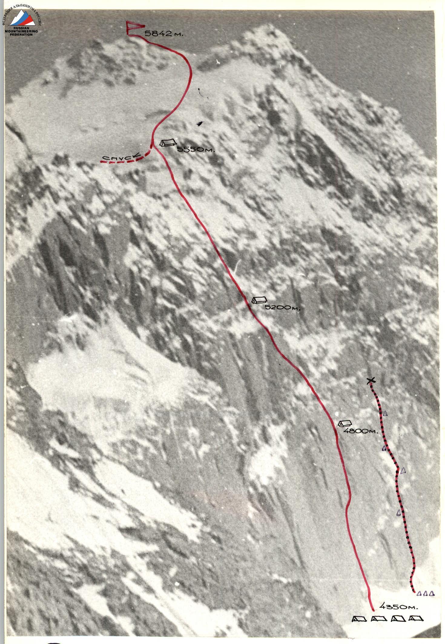
Map-scheme of the ascent area!

0
Brief Overview of the Ascent Area
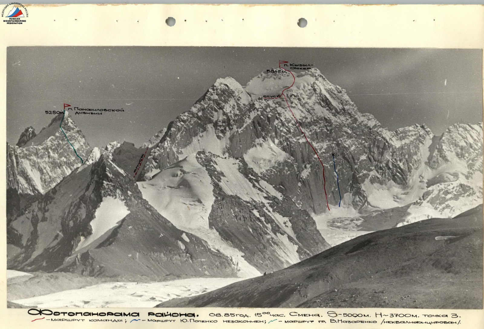
Peak Kyzyl Asker is located in the western extremity of the Kokshaal-Tau ridge in a group of peaks over 5000 m. The ascent area is situated in a border zone and is relatively infrequently visited by alpinists. In 1980, a team from the SAVO (led by Yu. Popenko) attempted to climb Peak Kyzyl Asker but had to abort the ascent due to an accident and injury to one of the participants (see photo). One of the groups from this expedition successfully made the first ascent of Peak Panfilovskoy Divizii (5250 m), but the route was not classified (see area map).
To reach the area, one can travel through the city of Naryn along the Naryn–Atbashi highway, turning off towards the village of Ak-Muz along the AKSAY river valley to the border post of the same name. From here, Peak Kyzyl Asker is clearly visible on a clear day, standing out due to its height and steep northwest wall facing the valley. By traversing relatively flat terrain, one can drive almost to the tongue of the Kyzyl Asker glacier, where there is a suitable location for a base camp. The approach to the wall takes about 5 hours.
The object of the ascent is very interesting. The northwest wall of the peak is about 0.5 km wide, offering several options for routes of higher categories of difficulty. However, the middle part of the wall is threatened by a serac hanging from the northern ridge. The following routes are of interest:
- Ascent via the northern ridge (4–5 category of complexity, approximately);
- Ascent via the western ridge (4–5 category of complexity, approximately);
- Ascent via the eastern ridge, possibly in a traverse from Peak Panfilovskoy Divizii.
To the north-northeast of the summit lies a powerful glacier that drops into the valley on a steep rocky ledge at a height of about 4500 m. The area's weather conditions are typical of Tian Shan — usually clear in the morning, with clouds and snowfalls approaching from the west by afternoon. The rock terrain is somewhat monotonous:
- steep, often vertical slabs without micro-relief;
- long cracks;
- wide, ice-filled cracks that allow the use of placement elements;
- few small cracks for piton belay.
The structure of the western wall contributes to the slippage of freshly fallen snow in the form of powder snow avalanches from its upper, less steep part. Snow melted on the rocks turns into rime ice by evening, greatly complicating the ascent in the morning hours. The team's actions during the ascent were determined by a tactical plan:
- the first climber went on a double rope (photos 1, 3, 7, 8, 6);
- practically all participants worked as the first climber, taking turns;
- this allowed for an even distribution of physical and psychological load on each team member.
The route was ascended with preliminary processing of the lower part of the wall (sections R1–R2), and further processing of sections R2–R13, R23–R24 from intermediate bivouacs:
- R2–R3
- R23–R24
Due to good team cohesion, even physical and technical preparation, and mutual understanding among team members, there were no fixed rope teams. The composition of the rope teams changed throughout the route. The change of lead climbers in the rope teams occurred on sections R3, R5, R8, R11, R16, R17, R19, R23, R25, R29. When processing, the working rope teams changed during the day, working 4–5 hours, allowing the team to advance intensively, 11–13 hours a day, throughout the route. Perils were organized on almost the entire length of the route (sections R0–R29). Bivouacs were set up in safe, overhang-protected areas, carefully observed while studying the wall (photo 9). The preparation of platforms for tents was done simultaneously with further route processing. The effort spent on preparing the platforms (photo 12) was fully justified by the quality rest.
The lower part of the route is a system of steep, monolithic slab-like walls with few handholds. The walls are ascended via vertical, wide cracks filled with ice and topped with cornices. The use of placement elements for quick belay organization and ITO (Intermediate Technical Object) significantly facilitated overcoming this most problematic part of the route. The second rock belt of the wall also required the full arsenal of rock climbing techniques and was ascended in bad weather accompanied by powder snow avalanches (photo 13). The descent from the summit of Kyzyl Asker via a pre-scouted path presented no technical difficulties. There were no accidents, injuries, or illnesses. Communication with the observation group was maintained via a VHF radio station — five communication sessions per day. Observers maintained constant visual observation of the team's actions using binoculars and a 60x spyglass. The observation group was located in the middle part of the Kyzyl Asker glacier, maintaining constant radio communication with the base camp and through it with the KSP of Central Tian Shan.
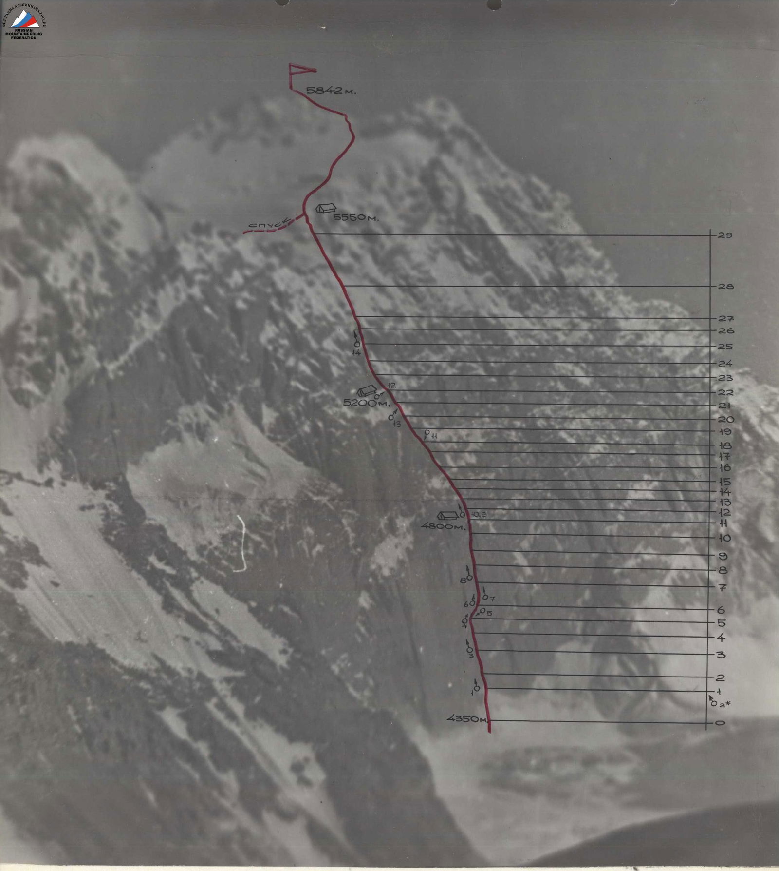
Route Diagram in ASAU symbols. Scale 1:2000
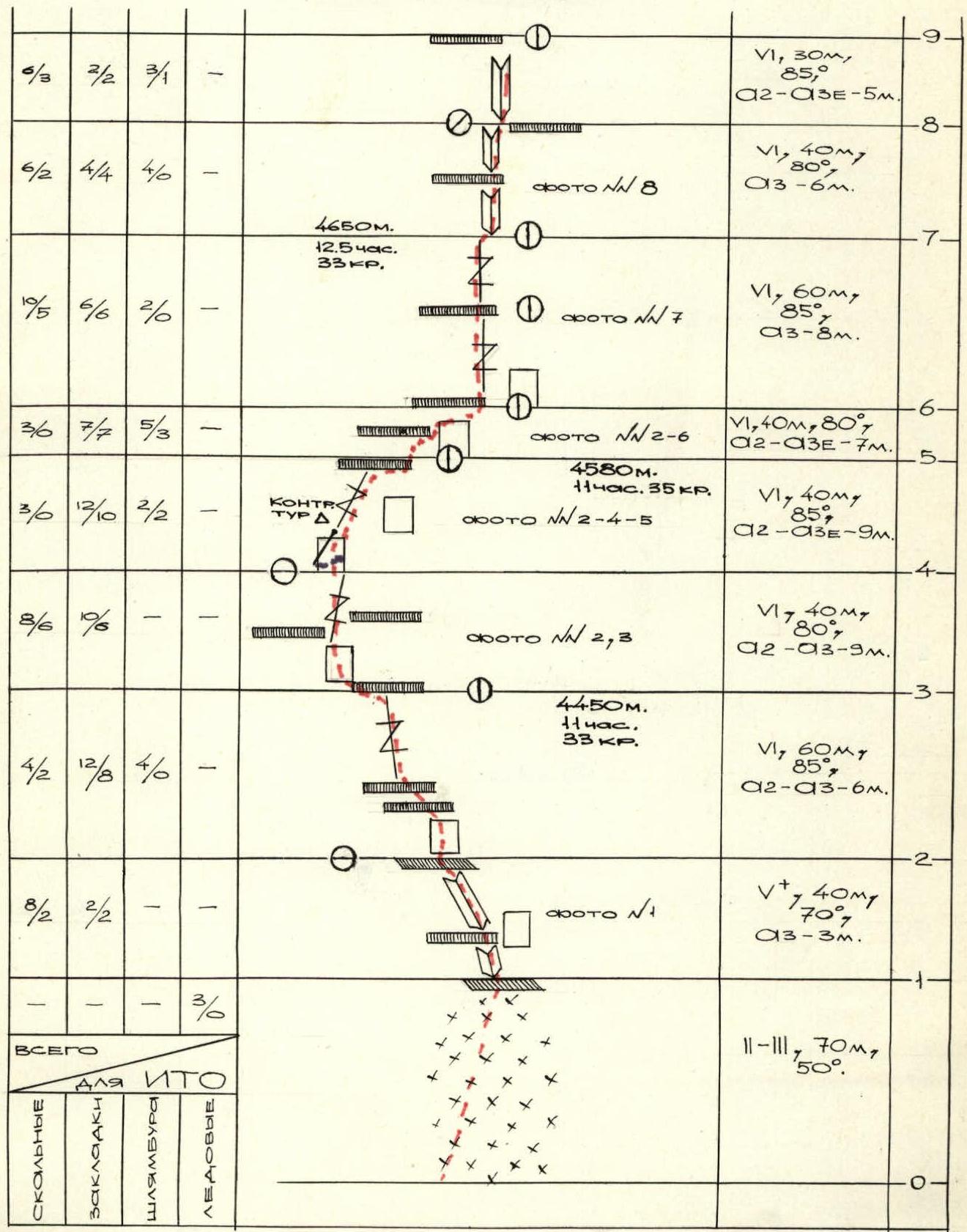
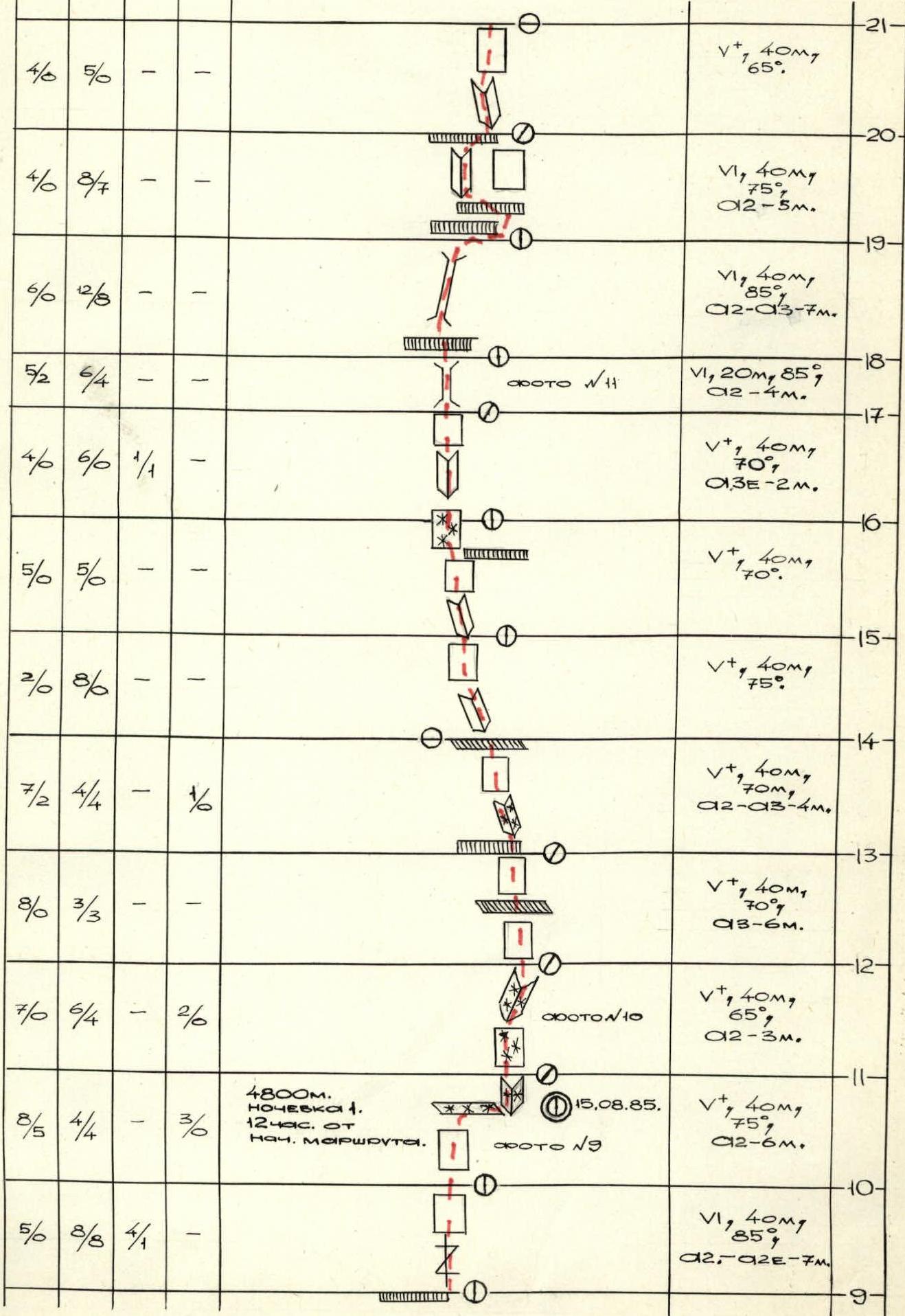

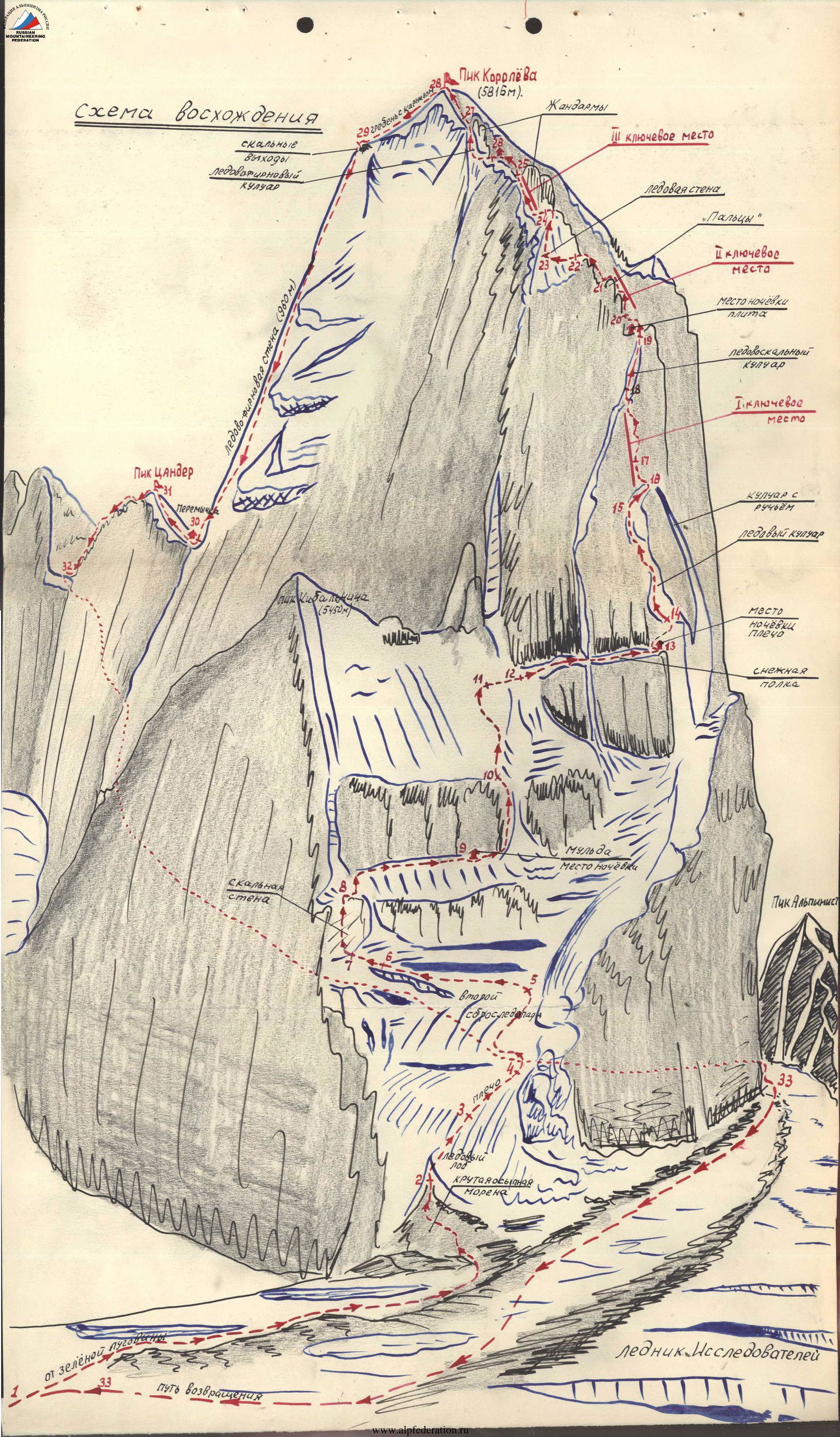
Description of the Route by Sections
Section R0–R1. After overcoming the bergschrund, move up and right along the ice slope under the wall and the characteristic internal corner with a cornice.
Section R1–R2. Photo 1. Along the internal corner through the cornice. Movement is complicated in the first half of the day by rime ice. In good weather, there is a waterfall here. Then, move up and left along the internal corner along the wall. At the end of the section, there is a shelf on the left, a convenient belay location.
Section R2–R3. Along the crack up, complex climbing, ITO. For belaying and passage, use:
- boxes;
- placement elements.
Section R3–R4. Photos 2–3. Under a small cornice, traverse left and up 10–15 m, then up along the vertical internal corner. The corner ends with a convenient ledge for 2 people.
Section R4–R5. Up the crack. At the end, organize a pendulum along the smooth slab 5–7 m to the right into a wide crack, then ascend up under a large yellow cornice. The latter is overcome in its right part. Photos 4, 5.
Section R5–R6. Above the cornice — a split rock, from which traverse right under the next cornice. Photos 2, 6. Underfoot is a steep slab with moss, very slippery, only ITO.
Section R6–R7. In the right part of the cornice, we transition into a long crack leading to the next belt of cornices, very steep, climbing is extremely difficult, ITO. Photo 7.
Section R7–R9. The crack turns into an internal corner filled with ice. The ice is very hard, difficult to clean the spot for a piton or placement element. Up under the cornice 30 m. Photo 8. The cornice is passed in its right part with an exit into the internal corner. Micro-relief is absent. Cracks for pitons are tightly filled with ice, so progress is slow.
Section R9–R11. Steep crack, then along the wall and into the internal corner under the split rock. All around, rime ice like armor. Much ice needs to be chipped away since its thickness is too small for ice pitons. A short ice section allows for a platform for a tent to be carved out on the right of the route. Photo 9.
Section R11–R12. From the bivouac, move up and left along the internal corner with ice under the wall with a small cornice. Photo 10.
Section R12–R13. Along the wall through the cornice. Rocks are heavily glazed, rime ice.
Section R13–R14. Straight up along the internal corner with ice.
Section R14–R17. Then alternate:
- steep walls;
- small internal corners with ice. We approach a steep wall.
Section R17–R18. Up the chimney under the cornice. Photo 11. From here, left through the cornice.
Section R18–R20. Up the chimney, the start is very difficult. ITO. A series of small cornices that are passed:
- in the right part;
- then left into the internal corner.
Section R20–R21. Steepness decreases. Internal corner, ice.
Section R21–R22. A string of steep rocks. The upper wall is partly ascended on ITO. Above, a series of small ledges battered by avalanches. Only one under the cornice. Bivouac. Photo 12.
Section R22–R24. From the bivouac, up, rocks are destroyed, two ropes under the sleeping bastion.
Section R24–R26. Steep, glazed slabs, small internal corners with ice. Photo 14. On the last 10 m — a cornice.
Section R26–R28. Along the snow-ice terrain to the rock outcrops.
Section R28–R29. Couloir with snow and ice and rock steps 2–3 m. Exit to the ridge — into a snow depression and onto the northern slope. Bivouac here.
Section R29. Summit. From the bivouac, 2 hours along the snow slope to the summit. Descent from the bivouac to the right, northeast along the icefall to its bend. Then left down under the slopes of the northern shoulder of Kyzyl Asker to the next ice drop. Here, left along the ice slope 1.5 ropes to the bend. From here, descend along the snow to the glacier.
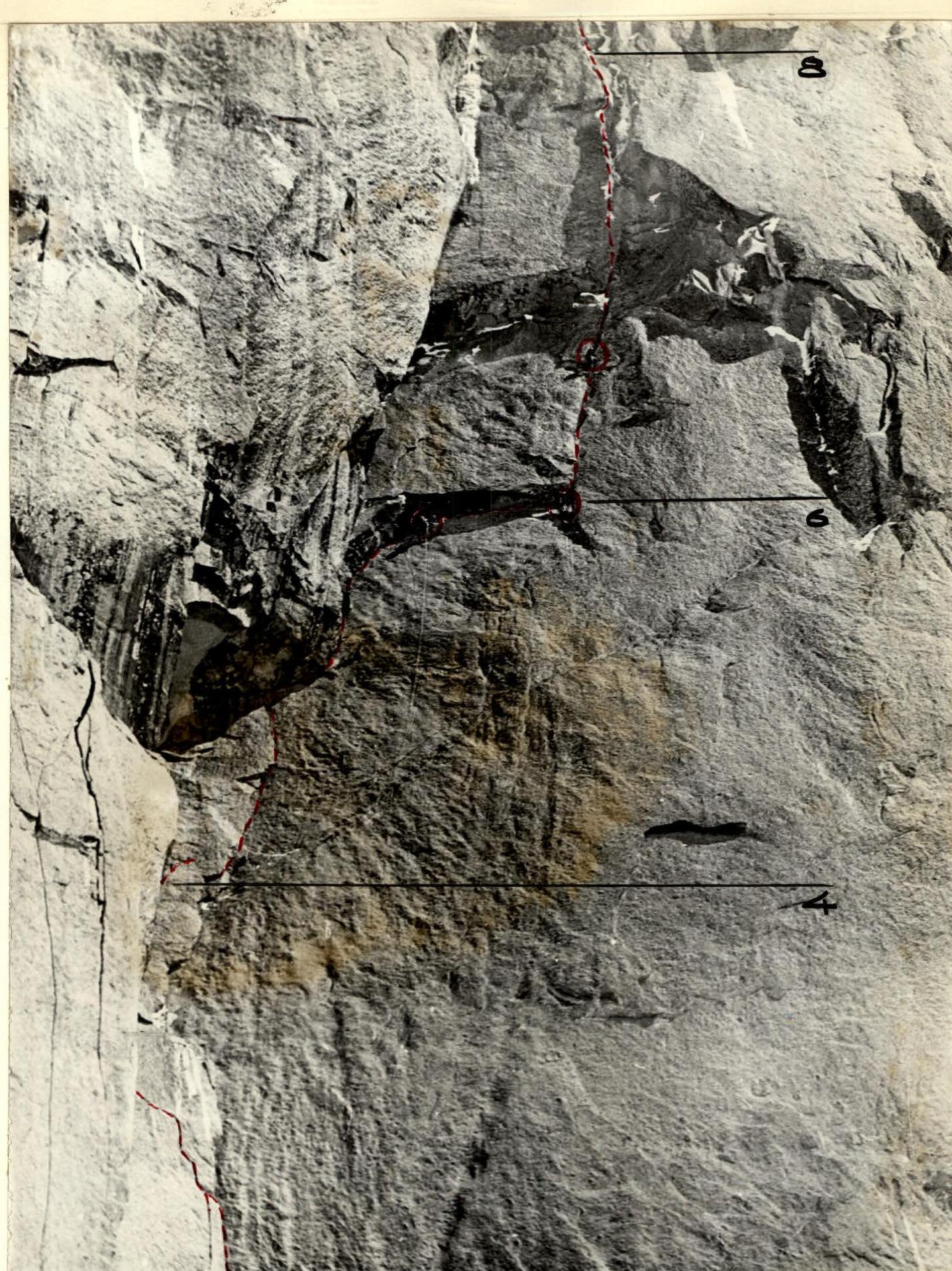
Photo #2. Sections R3–R8. Zenith. F = 135. H = 4400 m. S ≈ 0.5 km. Point 2*.
Technical photo of the summit. August 8, 1985. Zenith. Helios-50. S = 7000 m. H = 3700 m. Point 4.
Comments
Sign in to leave a comment