Ascent Passport
- Ascent category — technical.
- Ascent area — Central Tien Shan, West Kokshaal-Tau ridge.
- Peak — p. Krylya Sovetov via the north ridge.
- Proposed category — 5B, first ascent.
- Height difference — 1300 m. Length of sections with 3–4 category difficulty — 1750 m, 5 category difficulty — 480 m. Average slope of the main part of the route — 43°, Entire route — 37°.
- Pitons driven:
- rock — 32
- ice — 31 Left on the route:
- rock — 3
- chocks — 6
- ice — 2
- Team's travel time — 32 hours, days — 4.
- Overnights:
- 1 — at the start of the route on a saddle.
- 2 — on a snow drift on the pre-summit ridge.
- Leader — Monayenkov Yevgeny Ivanovich — Master of Sports.
Team members:
- Opoitsev Nikolay Anatolyevich — Candidate Master of Sports
- Lavrushev Nikolay Alekseyevich — Candidate Master of Sports
- Pankov Vladimir Petrovich — 1st rank
- Coach — Monayenkov Yevgeny Ivanovich — 142101, Moscow region, Podolsk, Pleshcheyevskaya st., 44-a, apt. 17.
- Departure to the route — August 9, 1998, summit — August 12, 1998, return to base camp — August 13, 1998.
- Moscow Region Alpine Federation — 103050, Moscow, Tverskaya st., 22-b, phone 299-97-67.
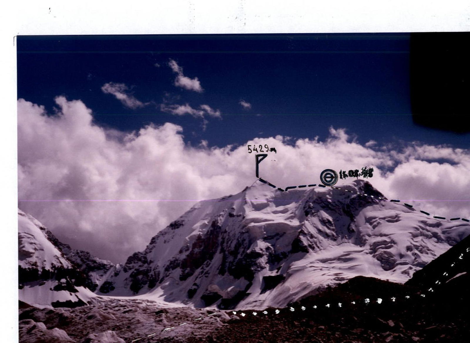
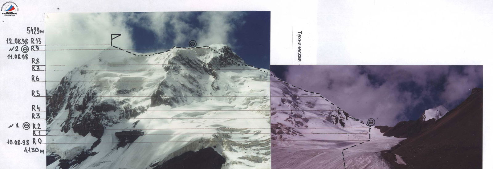
The team's route to p. Krylya Sovetov via the North Ridge (taken on August 10, 1998)
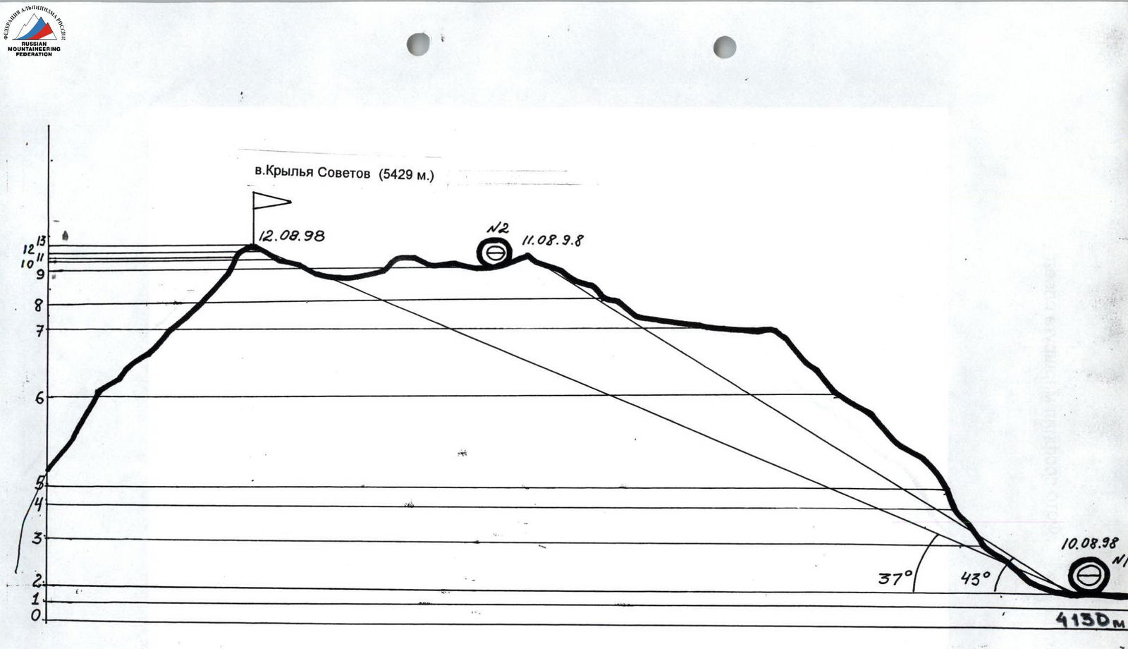
Hand-drawn route profile
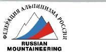
Photo of the route profile from the left
Brief overview of the ascent area
West Kokshaal-Tau is the southernmost and highest ridge of the mountain range formed by several latitudinal ridges (Terokey-Alatau, Jetym, Borkoldoy) located in Central Tien Shan between Lake Issyk-Kul and the Takla-Makan desert.
To the north, West Kokshaal-Tau is bounded by the Uzengi-Gush and Mudyuryut-Aksai river valleys, to the west and east — by the breakthroughs of these rivers through the main Kokshaal-Tau ridge, and to the south — by the Kokshaal river valley. This river system belongs to the Tarim river basin.
There are many peaks around 6000 m high. The most interesting ones (from west to east):
- p. Kzyl-Asker (5842 m)
- p. Krylya Sovetov (5429 m)
- p. Shmidta or Kosmos (5954 m)
- p. Dankova (5982 m)
- p. Chon-Turasu or p. Joldash (5729 m)
- p. Alpinist (5641 m)
- p. Koroleva (5816 m)
In 1938, the first and only pure mountaineering expedition of the "Krylya Sovetov" sports society, led by B. Simagin, was sent to West Kokshaal-Tau. Their attempt to climb the peak they named "Krylya Sovetov" was unsuccessful due to bad weather.
By now, ascents have been made to p. Kzyl-Asker, p. Dankova, p. Koroleva, p. Alpinist, and p. Krylya Sovetov, which we climbed this season. Of the five peaks conquered by climbers, three were climbed by climbers from the Moscow region (p. Koroleva, p. Alpinist, p. Krylya Sovetov).
The West Kokshaal-Tau ridge is composed of sedimentary, metamorphic, and igneous rocks from the Paleozoic and Precambrian eras (shales, sandstones, limestones, marbles, gneisses, granites, syenites, etc.).
The relief of most of the ridge is high-altitude. The ridge is characterized by a combination of typical Alpine forms (many steep walls with a height difference of 1.5–2 km, with significant snow cover and powerful glaciation, which is second only to the Peak Pobeda glaciation in Tien Shan).
The snow line is at an altitude of 4000–4500 m. River valleys have a relatively high absolute height (3000–3500 m). In many places, there are swampy areas even at altitudes of 3500–4000 m.
p. Krylya Sovetov (5429 m)
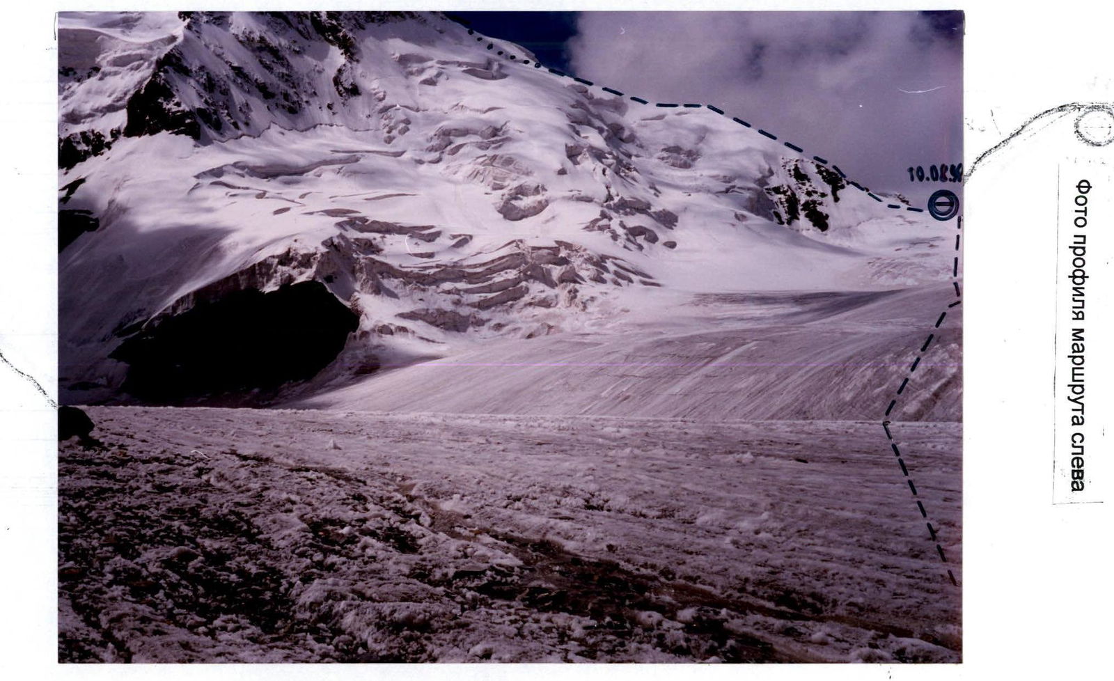
| rock | chocks | ice | sect. no. | cat. diff. | Length, m | Slope |
|---|---|---|---|---|---|---|
| 2 | 3 | 13 | 3 | 160 | 35 | |
| 7 | 12 | 5 | 25 | 65 | ||
| 6 | 2 | 11 | 5 | 40 | 53 | |
| 2 | 10 | 3 | 800 | 25 | ||
| 4 | 2 | 20 | 9 | 5 | 240 | 45-50 |
| 2 | 3 | 8 | 4 | 40 | 45 | |
| 4 | 2 | 7 | 3 | 300 | 25-35 | |
| 3 | 6 | 3 | 160 | 30 | ||
| 5 | 5 | 3 | 100 | 35 |
ROUTE SCHEME IN UIAA SYMBOLS
Not to scale
Note: the scale of the scheme is changed due to the large length and uniformity of the terrain of the route sections.
The climate is quite harsh. In summer, the average monthly temperatures in the valleys are 5–8 °C, and the average monthly precipitation is 20–30 mm. The weather is very unstable.
There is no permanent population south of the Naryn River. A small part of this area is used as temporary pastures. In the upper reaches of the Naryn River, intensive geological exploration is being carried out by a joint Kyrgyz-Canadian company. This company has built a good asphalt road from Lake Issyk-Kul to the gold mining site.
The Uzengi-Gush river valley is visited only by shepherds, hunters, tourists, and climbers. The approaches here along trails are quite long and difficult. The simplest but longest path is from the city of Naryn. The shortest but most difficult path is from the village of Karasay on the Naryn River bank.
We chose our path from the village of Barskoon, located on the shore of Lake Issyk-Kul, along an asphalt, and then a dirt road — mainly because we had two pre-booked GAZ-66 and ZIL-131 vehicles waiting for us here.
The entire journey to the base camp by car took us two days.
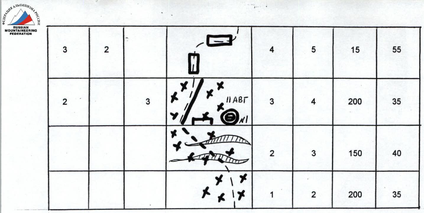
At first, we moved along the Karanukus valley to the Kuberventy pass through the Borkoldoy ridge. From this pass, a majestic chain of icy giants of the Kokshaal-Tau ridge from p. Kzyl-Asker to p. Koroleva opens up. From the pass, we turned east along the Katura valley. At the confluence of the Katura and Jurek rivers, the road passes among bizarre mountains of bright red color, resembling in shape:
- Egyptian pyramids,
- castles with balconies,
- arches,
- bridges.
The most significant of these is Kyzyl-Ompol (3926 m).
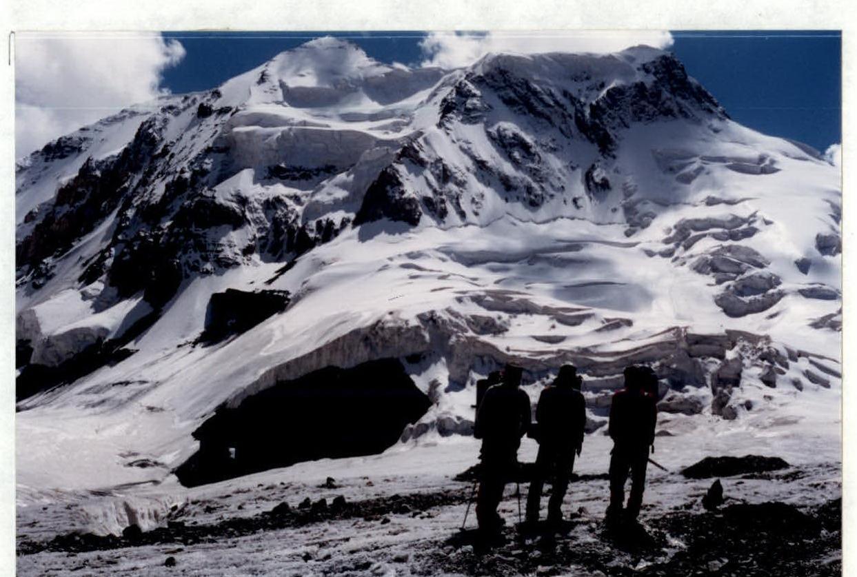
We set up our base camp on July 23, 1998, on a large, fairly flat green meadow, above the confluence of two rivers flowing from two parallel valleys and flowing into the Uzengi-Gush River. The left tributary originates from under the glacier of p. Dankova, and the right one — from the glacier under p. Krylya Sovetov.
Team's tactical actions
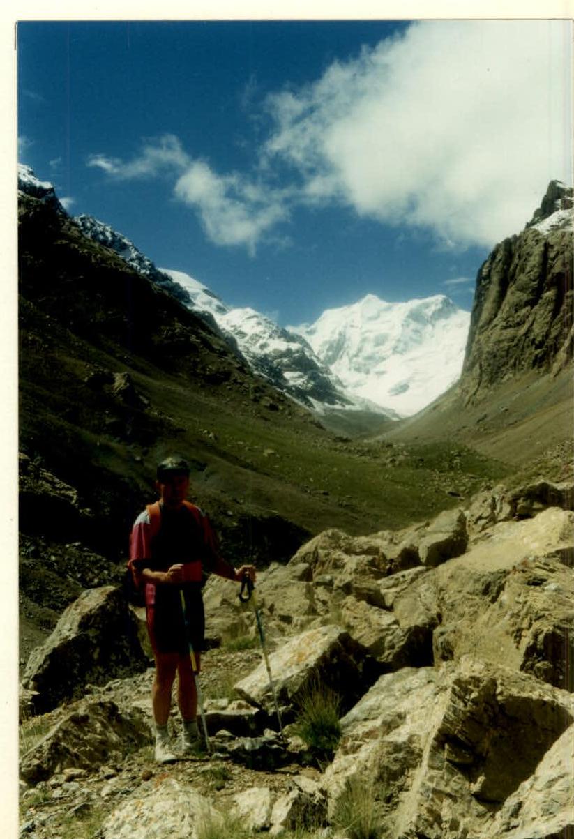
At 10:00 on August 9, the team left the base camp on a green meadow. After crossing the river and reaching its right bank, the path goes along a grassy slope and then along scree. There are areas of fresh rockfalls from the destroyed walls of the right part of the gorge. Along the way, we cross several streams.
We approached the glacier tongue at 14:00. The weather is clear and sunny. The path then goes along the glacier:
- at first along its left part,
- then along the center.
By 17:00, the weather worsened, and to avoid getting wet, we decided to set up a bivouac and spend the night.
On August 10, we continued moving along the glacier. The weather is good, and the chosen route to p. Krylya Sovetov is clearly visible. Further, our path lies to the right along the glacier leading to the saddle at the beginning of the North ridge. We organized a night's stay on the saddle at 15:00. We observe the route.
We plan to complete the planned route in five days, including the descent, and have one reserve day in case of bad weather. This tactical plan was later fulfilled by us.
When observing the route, we planned safe overnight stays on the ridge. All overnight stays are in a lying position on snow. An early departure from the bivouac sites was not planned since it is very cold in the morning, and it takes a lot of time to prepare for departure.
Each team member had to take turns leading on the route, alternating when passing the snowy ridge and slopes. Considering this feature of the route, the participants did not remove their crampons during the ascent, as frozen sections were often found under the snow.
The movement of the rope teams was organized:
- simultaneously and in turns,
- in some places — on fixed ropes.
Safety was ensured through:
- ice axes,
- ice screws,
- rock pitons.
The group is evenly matched in physical fitness, facilitated by regular joint training. During the ascent, a rescue team was on standby at the base camp. Throughout the entire route, there was stable radio communication with the base camp and the second team climbing another peak.
There were no falls, injuries, or frostbite during the ascent. According to the team members and the coaching council, the route taken is logical and safe. It can be recommended for teams climbing p. Krylya Sovetov for the first time. This route can be recommended as the primary descent option when attempting new routes.
Description of the route by sections
Section R0–R1. Simultaneous movement along a gentle glacier with closed crevasses towards the ice-snow slope rising to the saddle. Then along the ice-snow slope towards the saddle to the beginning of the North ridge.
Section R1–R2. Cross glacial crevasses on snow bridges and move along shallow snow to the exposed scree on the saddle. Overcoming it, reach the beginning of the North ridge of p. Krylya Sovetov. Safety is ensured through ice axes. On the rocky scree, we organized the first overnight stay.
Section R2–R3. 2nd day, August 11, 1998. From the overnight stay, move up the snow-ice slope to the snowy ridge, sticking to its right side (cornices). Further movement is in the direction of rocky outcrops on the ridge. Safety is ensured through ice axes and ice screws.
Section R3–R4. Movement along the ridge: snow, broken rocks. Approach under a 10 m rock wall. Ascend the broken rock wall with piton safety — exit to a ledge and along it to the right-up along the rocks — exit to the ice-snow slope. Further movement is along loose snow. Unusual snow and ice structure (layering, looseness). Use of ice screws.
Section R4–R5. Steep snow-ice slope, movement towards the rocks and, sticking to them, bypass to the right along the snow. Safety is ensured through alternating pitons and ice axes. Exit to a horizontal section of the ridge.
Section R5–R6. Movement along a steep snow-ice slope towards a protruding rocky triangle and exit to a snowy plateau. Safety is ensured through ice axes and ice screws.
Section R6–R7. Towards the rocky triangle — movement along deep loose snow. To the left remains a huge snowy cornice. Further:
- bypass the cornice along the 15 m ice wall to the right,
- then along the snow-ice slope — exit to the saddle under the rocks of the triangle.
Section R7–R8. From the saddle, to the right, bypass the triangle by traversing along a firm firn slope to the second ice-snow wide couloir from the triangle with a small rock wall in its upper part.
Section R8–R9. Further, the route goes to the right-up along a gentle rock wall with an exit to a large, narrowing at the top, snowy couloir. There are:
- sections of ice formation,
- "live" stones frozen in ice.
Piton safety. At the top of the couloir — exit to the right-up to the snowy ridge. Very tired. Heavy snowfall. With the help of a snow shovel and ice axes, we prepared a platform for the tent. Second overnight stay.
Section R9–R10. 3rd day, August 12, 1998. From the overnight stay — movement along a wide snowy ridge simultaneously, in the direction of the summit tower. Clear, cold wind. Snow is loose, deep. Difficult to form steps.
Section R10–R11. The snowy ridge abuts a 40-meter internal rock corner filled with ice and along it — to a rocky ledge covered with snow.
Section R11–R12. From the ledge along a 25-meter rock wall straight up to a small platform. Difficult climbing, piton safety. From the platform along the next rock wall to a snowy dome leading to the summit.
Section R12–R13. The upper part of the dome is difficult to pass due to deep loose snow. Cold, windy. At 15:00, we reached the summit. We built a cairn at 15:30 on the rocks below the snowy dome. We began descending from the summit along the ascent route.
On August 13, 1998, we returned to the base camp.
Start of the approach to p. Krylya Sovetov
 www.alpFederation.ru↗
 www.alpFederation.ru↗