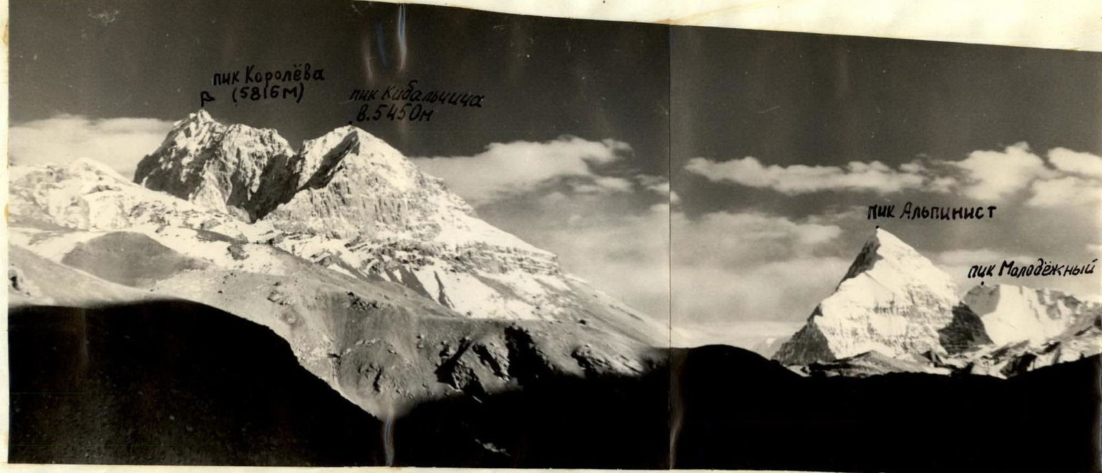
 Panorama of the Researchers Glacier
 www.alpfederation.ru↗
3. Climbing Conditions and Tactics
The West Kok-Shaal-Tau region, like the entire Tian Shan, is characterized by:
- heavily fragmented rocks,
- ice collapses,
- an abundance of dry, powdery snow.
In connection with this, it was necessary to prepare for overcoming rockfall-prone areas and for extensive ice and snow work.
The weather in this region is not very stable. Often, in the second half of the day, it deteriorates, and clouds envelop the peaks of Chon-Tarasu, Dankov, and nearby peaks.
At an altitude of 4500–6000 m:
- it is quite cold;
- strong winds blow almost constantly.
Periods of relatively good weather occur in the first half and mid-August. However, by this time, ice is exposed in many places.
During the preparation period, the participants made ascents to the following peaks:
- Peak "Zenit" (5500 m)
- Peak Kaliningrad (4740 m)
- Peak Zander (5600 m)
- Peak Dementyev (4500 m).
As a result of these ascents, familiarization with available materials, observation, and study of the upcoming route in close proximity, it was established that the key sections of the ascent up the western wall to the 5816 m peak are:
- The direct ascent up this wall.
- Passing the ridge of the counterfort.
- Bypassing and ascending the Gendarmerie on the pre-summit ridge.
- Descending down a steep ice-snow wall to the saddle towards Peak Zander.
The following ascent plan was drawn up:
- Day 1 — base camp overnight stay at the green meadow.
- Day 2 — ascent via moraine and icefall.
- Day 3 — exit under the wall and processing the beginning of the wall.
- Day 4 — passage of the wall with overnight stay on the edge of the counterfort, processing the further route.
- Day 5 — ascent to the summit, overnight stay under the summit.
- Day 6 — descent down the ice-snow slope.
- Day 7 — reserve day for bad weather.
In doing so, they tried to take into account the experience of their previous ascents in this region, and in planning the days, they made a time reserve for the deceptiveness of scales. To lighten the backpacks, they made a cache of supplies under Peak Zander.
The following decisions were made regarding equipment:
- Due to the fragility of the rocks, everyone must wear helmets, and it is necessary to have pitons for driving into wide cracks (ice axes).
- Since there is a lot of ice and hard firn on the route, everyone must wear crampons and have a full set of diverse pitons. Since a large number of ice screws were expected to be used, titanium-made screws were taken to lighten them.
- In case of loss of a backpack, each type of communal cargo should be carried by at least 2 people.
Since the route will mostly pass through a rocky wall, the most convenient and safe group size is 4 people.
The rope teams were distributed as follows:
- Alibegashvili L. and Okhrimenko S.
- Korolkov B. and Strikitsa N.
Safety was ensured by interaction with the observation group led by Ivanov V. (Zherdev V., Vorobyov V., Kukushkina S., Ivanov V.) and with the traversing group of our expedition led by Korsun A., which was making a traverse of the entire massif of the 5816 m peak and the peaks lying in this ridge. Communication with these groups was maintained via radio and with the help of flares.
1. Route Description
1st Day. August 9, 1969
On August 9, 1969, a group of climbers from the Mos DSO "Zenit" in the amount of 4 people left the base camp under Peak Chon-Tarasu to ascend the western wall to the 5816 m peak (Peak Korolev).
Moving up along the trail along the left (in the direction of travel) slope, in 4 hours, the group reached a bivouac with a green meadow at the left slope between the terminal moraines of the Researchers Glacier, which comes from the China-USSR pass (K1). The weather has been clear for several days.
2nd Day. August 10, 1969
We left the green meadow at 6:45 and, staying on the left moraines of the glacier and the leftmost glacial stream, approached under the hanging glacier coming from the western slopes of the 5816 m peak in 3 hours 45 minutes. This glacier descends in three icefalls from under the wall, transitioning into the summit ridge. This will be the path of our further route.
We begin to ascend the steep talus moraine to the middle open ice of the first icefall.
On the pure ice, it is necessary to go in rope teams and, desirably, in crampons, as the first icefall is passed over a steep, pure ice forehead with the driving of ice screws; the lateral slopes of the ice forehead turn into collapses with many crevasses.
Further, deviating to the right, we pass the first gentle shoulder and, traversing with a gain in height, the right ice wall of 50–60° of the second icefall, we move to the second. Then we cross the slope to the right with an exit to a narrow snow-covered ledge under the main wall of our planned route. The ledge is quite simple. Along it, we pass to the right across the entire wall and exit onto a snow-covered shoulder, which breaks off downwards to the third stage of the icefall. To the left is the main wall, to which we still need to cross a couloir and traverse a small wall. Here we organize our second overnight stay. The shoulder allows for setting up even two tents, but first, we need to cut out the snow and ice. There is no water.
Two of us start preparing a place for the tent, while the other rope team goes on reconnaissance and processes the further route. On this day, we managed to pass and fix three more ropes along the ice couloir and wall, and already at dusk, we descended to the overnight stay site. The tent had not been set up yet, as we had to cut out a lot of ice with embedded stones. Further ascenders should take this into account.
Weather:
- Frosty
- Clear
We set up the 1st cairn.
4th Day. August 12, 1969
We leave the bivouac at 8:00. Along the fixed ropes, we traverse a small wall and couloir, approach a ledge on which the ice couloir ending to the left. Further from it passes another deep ice couloir with a functioning stream, going all the way down to the glacier. From the snow-covered ledge, to the left and upwards, along a very steep ice couloir (in crampons), we pass to its narrowest and most vertical part, then, removing them, along the left wall of the couloir, which is a very difficult vertical wall with small crystalline pyramids of rock, we ascend to a short ridge going to the right towards the main wall.
Further along the ridge, we approach under the first key section of the main wall. Here our fixed ropes ended. The first person puts on climbing shoes, and everyone else goes without backpacks.
It should be noted that up to this point and after, the rocks are composed, as already mentioned, of sharp crystals. The shoulder of the icefall.
We cross the entire glacier to the left and exit under the left walls coming from the lower part of the main ridge of the 5816 m peak. Here the glacier is closed and hazardous; we have to cross several closed crevasses.
The ascent under the left walls passes along:
- a not very steep 20–30° snow-ice slope
- a rocky wall 10–15 m long
Further along the wall, along a snowy ledge, we traverse to the right, the upper part of the third icefall, and enter under the neck of the couloir going to the left of the wall we have planned.
Here, in a hollow, under an overhanging rocky outcrop, we make a good overnight stay. There is water 40 meters away, running down the wall. The weather throughout the day remains clear.
From here, our further route is clearly visible. Another path variant is visible:
- directly along the snow-ice slope
- along the ice couloir to the ridge leading to the summit
The ridge, just like on our route, approaches the wall. The route is also logical and a bit simpler than ours. But ours leads out to the ridge closer to the summit, so during preparation for the ascent, we opted for it.
3rd Day. August 11, 1969
Departure at 7:00. Along the snow-ice couloir in crampons, we exit onto the upper steep slope. Further along small rocky islands and ice walls, we approach the middle part of the slope.
The rocky islands are like "roches moutonnées" from a distance. Up close, the rock structure is fine-crystalline, with sharp pyramids 2–3 cm high. They crumble easily; the cracks are very thin. It is difficult to find cracks even for a petal hook.
Features of climbing on such sections:
- Complex climbing due to small holds and sharp edges of the pyramids;
- Hands quickly start bleeding;
- Almost no pain is felt,
- and climbing in gloves is difficult due to small holds and footholds.
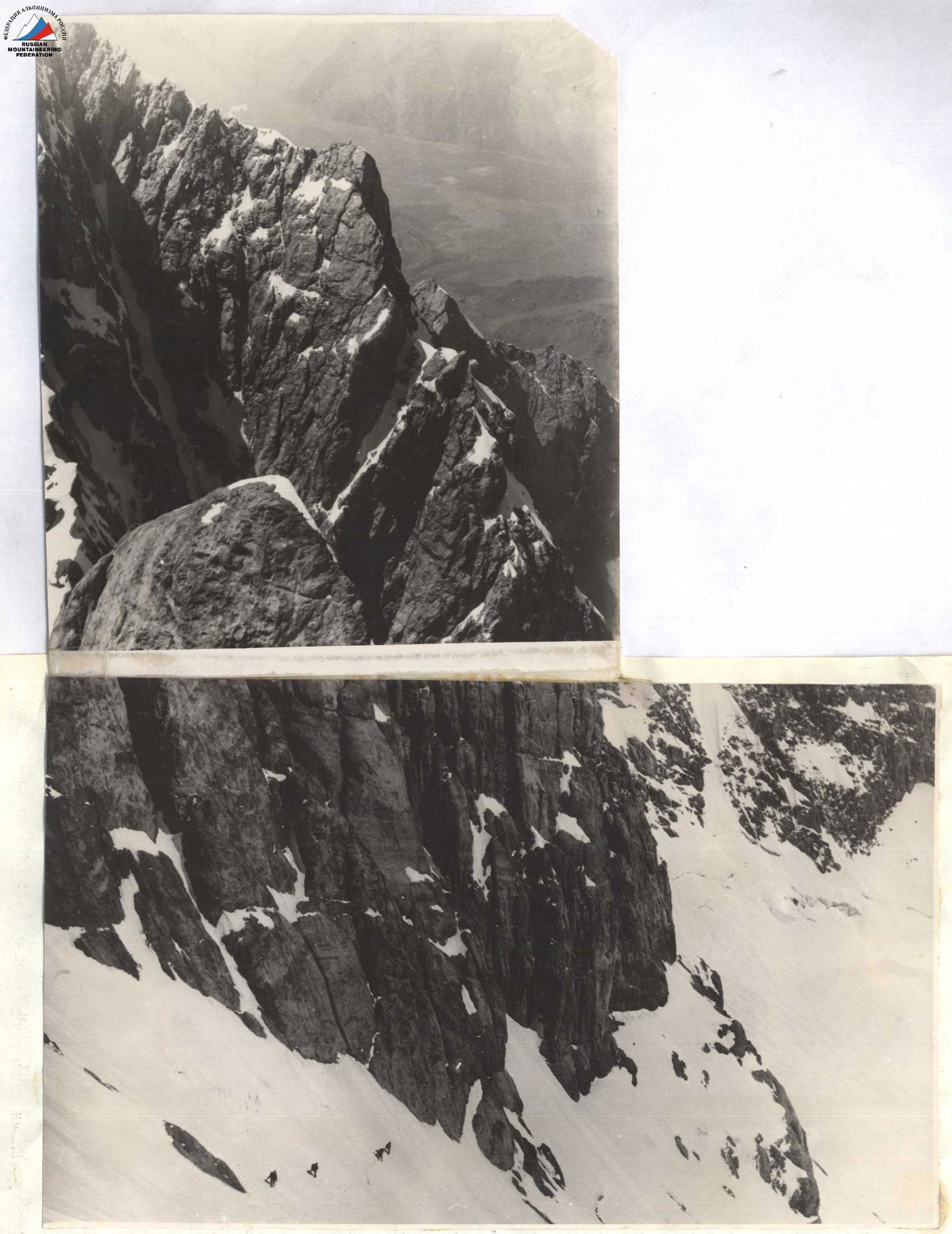 Characteristic sections of the ascent route up the western wall to 5816 m.
2–3 cm, which crumble. For belaying, we used large blocks, padding their sharp edges, and tried to find wider cracks to drive in duralumin wedges or ice screws. We want to immediately draw attention to the fact that it is possibly easier to organize belays on bolt anchors. Petal hooks had to be driven in more reliably with 3–4 attempts. So, a lot of attention and time have to be devoted to the organization and choice of belay points. This should also be taken into account by further ascenders.
To the left, along one rope, we exit along the wall under a clearly visible single internal angle on this section of the wall. On the rocky outcrops, there are many loose stones. Here is a small platform for one person; there are cracks for belaying.
The internal angle is a vertical, as it turned out later, with three negative выступs (only one is visible from the platform).
Further, the wall exits into a couloir, which descends along the wall from the right side. The route is vertical and logical; it is difficult to deviate to the right or left (it's worse and more complicated there).
Features of the passage:
- It is necessary to use ladders and bolt anchors.
- This is a key section of more than two 40 m ropes.
- Backpacks are pulled up in two stages.
- Subsequent climbers should also help to ascend to shorten the time.
The further path is 4 ropes of rocky-ice couloir. The couloir consists of vertical sections with hanging ice 10–15 m, icicles, and more gentle ledges. The end of it is guessed against the sky.
In the couloir, there are:
- places with cracks for belaying;
- places with good ice for ice screws (preferably, screw-in type).
In the upper part of this couloir lies a ten-meter snow ribbon. The couloir exits onto the ridge of the counterfort.
In the middle of the couloir, after one and a half or two ropes, a seemingly convenient path to the left is visible. Further, it exits into another, more hazardous couloir, where stones fall from the wall above. It is simply not advisable to go this way.
In our couloir, there is a danger from stones dislodged by those climbing ahead; one has to watch out for them and be very attentive to the rope to avoid it being cut.
On the ridge of the counterfort, we organized an overnight stay. There is:
- to the left of the ridge, a slab on which one tent can be set up by laying stones on the edges, held together by snow;
- water is absent; there is snow;
- 70 meters higher, there is a ledge on which 4 people can sit. Here we left the second cairn.
The further path along the ridge of the counterfort is to the left, but immediately from the overnight stay, there are two "fingers" (gendarmerie). This, as we believe, is the second key section.
The gendarmerie — "fingers" in the form of sugarloaves with vertical walls, stand one above the other:
- to the left — an ice collapse;
- to the right (in the direction of travel) — a wall going down; what's below on the wall is not visible.
On this day, we managed to process and fix a rope on the first "finger". The holds are small, sharp pyramids like in previous places; there are no cracks. We used bolt anchors.
The "fingers", like the further ridge of the counterfort, were passed in climbing shoes. Climbing is very complex and also hazardous. The last participant clearly saw two bloody streaks from our hands. Hands were bleeding heavily, but during the passage of these gendarmerie, there was no feeling of pain.
The weather was clear throughout the day.
5th Day. August 13, 1969
We set out on the route at 9:00. The weather is clear, but there is a strong wind; it's cold. After passing the "fingers" with the pulling up of backpacks in two stages, the further path along the sharp, steep 60–70° ridge of the counterfort became visible. But here, at least, there are good cracks and ledges.
The ridge approaches under a wall, which is bypassed by a traverse to the left. One has to cross the beginning of two ice couloirs and exit under a snow-ice slope with a steepness of 40–50°, exiting onto the main summit ridge under a gendarme.
Choosing snowy sections, we ascend this slope. We go in crampons. Belaying is through ice screws; the snow is dense. We exit onto the ridge under a gendarme. Here begins the third key section — one of the most complex.
At this place, we found a huge vein with red and pink calcite crystals. We bypass the gendarme to the left along the wall. The wall consists of snow-covered ledges; on this side of the slope, the snow is loose, and every ledge or outcrop has to be cleaned. A strong upper wind blows. The frost is felt.
The belaying is with pitons; the cracks are good, and the rocks are already monolithic, with large blocks. Further, the entire ridge consists of the good monolithic rocks.
After the gendarme, the path is along the usual simple snow-rocky wide ridge. Here there are many places suitable for overnight stays. We establish communication with the observers of the base camp. We receive a radiogram about the approaching bad weather. We decide to continue the ascent and descend on the same day.
The next gendarme is also bypassed to the left along a steep ice-firn couloir with a steepness of about 70°. We pass in crampons; belaying is organized through ice screw anchors. Behind the gendarme, the snowy ridge in four ropes leads out to the summit.
The summit is a snowy overhanging cornice with a cornice to the east. Below, we see the previous group descending for an overnight stay. We find the summit cairn one rope below the summit on the rocky outcrops. The weather starts to deteriorate; clouds pass over the summit; in the breaks, there is sunlight. The wind is gusty, making it hard to stand. We have to wait out these gusts. The frost is severe.
The previous group of first ascenders-traversers suggests in a note that this unnamed 5816 m peak be named Peak Korolev. We also support their proposal to name this peak after the rocket ship designer.
Descent from Peak Korolev back down one rope and further to the right.
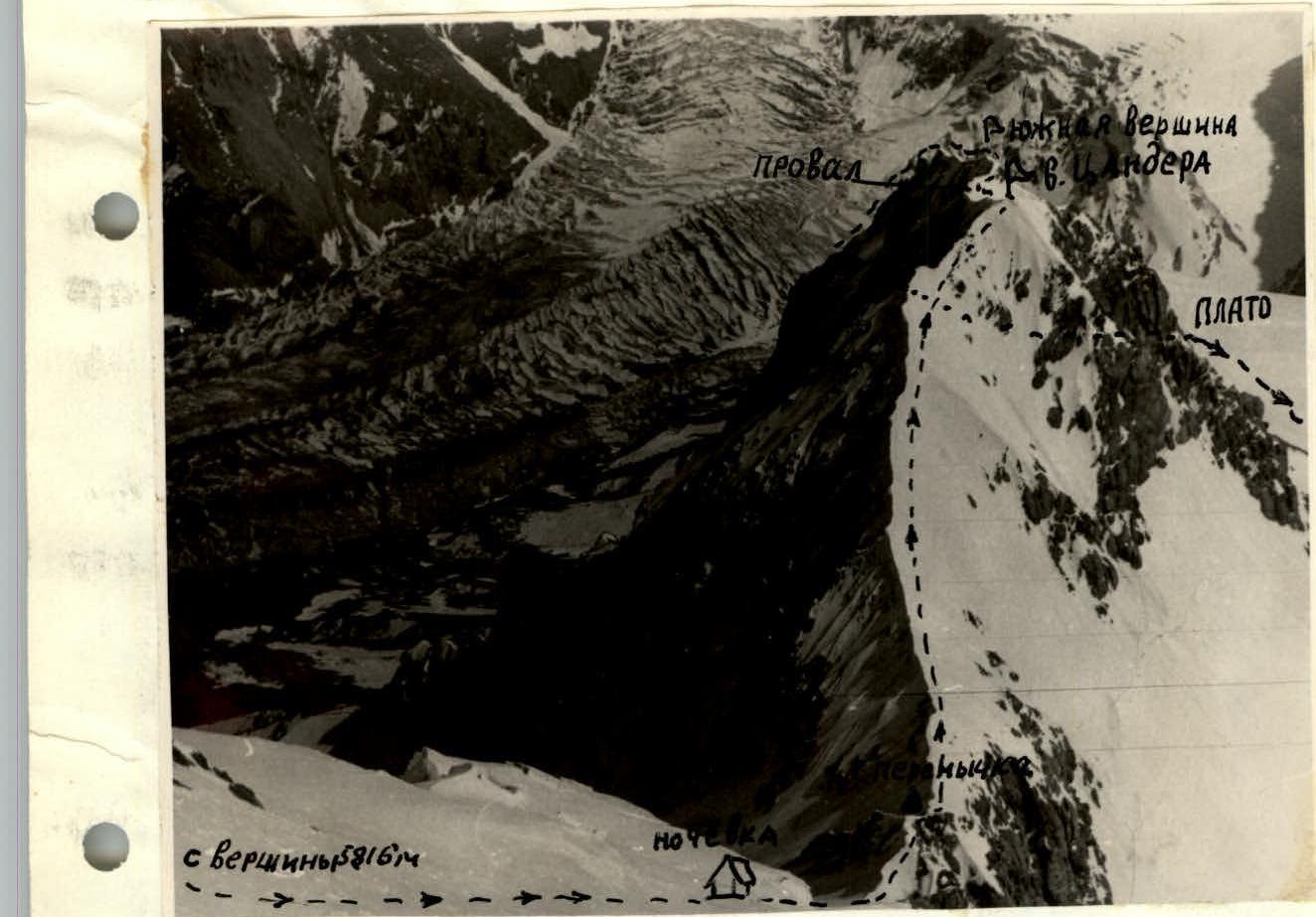 Section of the descent via Peak Zander.
To the right (in the direction of travel) along the sharp snowy ridge going to the east. Not reaching the rocky outcrops on this ridge, in three–four ropes, we start descending to the right down a steep ice-firn wall of 50–70° vertically down, onto the saddle between this wall and the rib going to the next two-headed peak of this ridge — Peak Zander. We pass this wall on ice screws and crampons. It turned out to be 24 ropes long. On the descent, we warmed up. The traces of the previous group are noticeable. Late in the evening, we descended into their tents.
6th Day. August 14, 1969
Departure at 10:00. Further path along the saddle to Peak Zander.
Ascent:
- Along the snowy steep wide rib to the main summit;
- After a pitfall — to the southern summit;
- Further along the rocky ridge, staying on the left side (in the direction of travel), descent along the route 4B cat. diff. to the saddle between Peak Zander and the next peak in the ridge.
Descent:
- The rib has good rocks; there are many ledges.
- On the descent from Peak Zander, it is necessary to organize descent sitting on ropes at three places (walls 30–35 m).
- The last rope to the saddle is more convenient to descend along a snowy wall and couloir sportively. Before that, you can leave loops.
The saddle:
- Represents a fairly good plateau with an average slope of 25–30° towards the Researchers Glacier, coming from the China-USSR pass;
- From the saddle, descent to the right to the visible Researchers Glacier;
- On this saddle, we had a cache of supplies;
- You can untie.
Further:
- Along the glacier, on the right side (in the direction of travel), down to the green meadow;
- The entire massif of Peak Korolev remains to the right in the direction of travel;
- From the saddle to the green meadow — 5–6 hours of walking;
- We were already in the twilight on the green meadow.
On the next, 7th day, August 15, 1969, both groups descended to the base camp at 10:00.