
REPORT
on the first ascent of Peak Dankov (5982 m) via the Southwest wall, announced in the championship of the Armed Forces of the USSR on mountaineering in the 1972 season
Team: SKA SAVO
August 1972
Team captain — A. Ilyinsky, B. Gulnev Team coach — L. Kiselev Alma-Ata, 1972
1. Characteristics of the Region
The West Kok-Shaal-Tau ridge is oriented in the latitudinal direction. To the south, it is adjacent to the Takla-Makan desert, and to the north, it is bounded by the powerful mountain ranges of Terskey-Alatau, Boroldoi, and Jetym (Fig. 1).
The area around Peak Dankov, the highest point of the West Kok-Shaal-Tau ridge, is characterized by quite unstable weather, strong winds, and abundant snowfalls.
However, due to the high dryness of the air and strong winds, the freshly fallen snow usually melts within a day, facilitated by abundant avalanches. The snow line is located at an altitude of 4200–4300 m. The structure of the snow, especially on the slopes with northern exposure, is powdery and friable.
Geologically, the peaks in the upper reaches of the Dzhurek River are composed of weakly weathered marbled limestones, with outcrops of calcite. The surface of the rocks is wavy and appears polished, making movement difficult. This is due to the outcrops of limestone layers rich in fossilized calcareous algae. In some places, there are very bizarre magmatic rocks.
The exploration of this region by mountaineers began in the 1930s. After visiting the mountainous region southwest of Lake Issyk-Kul in 1929–1930, N.N. Palgov compiled a detailed description of the Kok-Shaal-Tau ridge, which attracted the attention of mountaineers and mountain tourists.
In 1933, the first group, organized by the tourist section of the Moscow House of Scientists under the leadership of A.A. Letavet, headed to the northern slopes of the western part of the Kok-Shaal-Tau ridge. The group made several trips, including one to the Dzhurek River valley, to the glacier named after Professor-Geographer Grigoriev. The surrounding peaks captivated A.A. Letavet with their inaccessibility and beauty, and he wrote that this area was "tougher than the Biwengian Wall."
In 1938, six mountaineers from the "Krylya Sovetov" society, led by B. Simagin, attempted to ascend an unnamed peak in the upper reaches of the Palgov Glacier. However, the group was forced to turn back just below the summit due to bad weather.
It wasn't until 31 years later, in 1969, that mountaineers returned to this remote and infrequently visited region. A team from the CSDAO "Zenit," led by P. Povarnik, conquered several major peaks in the area of the Researchers Glacier.
In 1970, CSDAO "Enbek" organized an expedition to the area of Peak Dankov. The team of mountaineers, participating in the USSR mountaineering championship, completed a traverse of the main peak of the ridge, Peak Dankov, under the leadership of Yu. Cherepinsky.
The region remains relatively unvisited, despite the abundance of beautiful peaks and technically challenging routes.
2. Preparation for the Ascent
a) Selection and Reconnaissance of the Ascent Object
The Southwest wall of Peak Dankov was chosen as the object for the future ascent in 1970, during an expedition by the CSDAO "Enbek" team. The route is primarily icy, with two belts of rocks in the middle and before the summit, which are complex to navigate. The height of the route increases the difficulty. The route passes through icefalls in two places. Observations established that these sections should be traversed early in the morning. Deviating from the planned route to the left or right increases the danger of icefall, as these areas are swept by ice.
Based on observations from 1970 and before the ascent, the route was finalized, and potential bivouac sites were identified. The preliminary assessment indicated that the ascent would take 7 days.
b) Team Composition
The coaching council approved the assault group in the following composition:
1st group:
- Ioakhim E. — leader, CMS
- Mitrokhin Yu. — participant, CMS
- Mikhin V.
- Kiselev D.
- Zhilenko I.
2nd group:
- Ilyinsky A. — leader, CMS
- Gulnev Yu. — participant, MS
- Kuramshin R. — participant, CMS
- Kapanin V.
All team members regularly trained on complex rock and ice sections. Typically, each mountaineer would climb up to 200–250 m of complex rocks in the Medeo area and the Tuyuk-Su area at altitudes of 2700–3500 m during training.
c) Organizational Plan for the Ascent
The organizational plan aimed to conduct the ascent at a high pace, in minimal time, while ensuring all necessary safety measures.
To achieve this:
- The team was composed of mountaineers with years of experience working together and who demonstrated high technical preparedness during rock and ice training this season. Their moral and volitional qualities were also considered.
- Careful selection of rock and personal gear, as well as food supplies.
- A thorough review of the route.
- Preliminary discussion of interaction options and methods for navigating the most challenging sections.
- A reliable communication system using rockets and a flashlight with observers positioned directly below the wall, allowing them to see the climbers with a 40x telescope.
- Observers communicated with the base camp using a P-126 radio station.
- The first rope moved with a double main rope.
- A thorough medical examination before departure.
- Interaction with the second group, which departed a day later.
d) Tactical Plan for the Ascent
The tactical plan for the ascent included the following:
- Completing the wall ascent in 7 days, with one or two days for descent to the Grigoriev Glacier. In case of bad weather, an extra day's ration of 0.2 kg per participant was allocated.
- Organizing lying-down bivouacs in the lower and middle parts of the wall, as they might not be possible in the upper part. While two team members continued processing the wall, the others set up the bivouac.
- The first climber always went without a backpack on a double rope.
- Changing the leading rope team and the order of the rope teams to ensure maximum speed and safety.
- Interaction between the two groups on the route, with the second group joining the first during the summit push.
3. Ascent Conditions
The Southwest wall of Peak Dankov has an average steepness of 60–65°. Ice sections have a steepness of up to 50–55°. In many places, the rocks are covered with flow ice. The entire wall, except for the last day, was climbed in good weather. At heights above 5500 m, strong winds were frequent. The altitude increased the difficulty of the route.
In the event of prolonged bad weather, ascending this route is not advisable.
4. Route Description
July 28. We departed from the base camp, located above the terminal moraine of the Grigoriev Glacier, after lunch. It took 2 hours to traverse the moraine and the Grigoriev Glacier. Then, we climbed a steep slope via a very fine scree under the Southwest wall of Peak Dankov. The weather deteriorated by evening, with snow and wind. Due to the bad weather, we were forced to pitch a tent and spend the night.
July 29. Departure at 8:00. Climbing up a scree-filled couloir took 1 hour. The scree couloir led us under the rock massif of Peak Dankov. We moved along the rocks to the right via a steep snow-ice slope. The insurance was alternating through protrusions and pitons. Often encountered ice or ice with embedded rock fragments. The slope's steepness was 55–60°. The length was 500–600 m (R1). On this section, 5 rock and 3 ice pitons were hammered. The snow-ice slope led to a saddle, where we organized our second night's bivouac. The 1st control cairn was established. The Mikhin-Kiselev rope processed the further route. 160 m of rope were fixed (R2). The route then proceeded through an icefall.
July 30.
Departure at 4:00. Exit at 5:00. An early start was necessary to pass under the icefall. From the bivouac site, we moved left onto the wall. 60 m of smoothed rocks with a steepness of 55°. The rocks were sometimes covered with snow. Under the snow, ice was occasionally encountered. Cracks for pitons were almost absent. Mainly, rock cracks suitable for petal pitons were found. A three-step ladder was used once. 9 rock pitons were hammered. The lower icefall was visible. Straight up the steep ice slope for 100 m. There were rock fragments embedded in the ice. 5 ice and 3 rock pitons were hammered. The exit was under the lower icefall. The icefall was bypassed on the left via a steep ice slope. The ice slope, with a steepness of up to 60° (120 m), led above the lower icefall (R3). Insurance was provided by alternating pitons. 12 ice pitons were hammered. We proceeded on crampons, clearing snow to reach the ice. On a gentle plateau, we simultaneously approached the lower rock belt. Yuri Mitrokhin led. 60 m up a very complex wall (R4). A ladder was used. Backpacks were hauled up. Insurance was via pitons. Then, along a very narrow ledge (R5) with overhanging rocks, 120 m to the left. Insurance was through rock pitons. The ledge led to a steep ice ridge, forming a saddle between the upper icefalls. Up the ice saddle, straight up 150 m, we exited above the upper icefall (R6). Insurance was alternating through ice pitons. We moved on crampons on ice. Sometimes the ice was covered with snow. The snow did not hold; we had to clear the ice to prevent crampons from getting clogged with snow. At the top of the icefall, the snow was deeper. We organized a bivouac under the shelter of a small ice wall.
July 31. Departure at 8:00. Up a gentle snow plateau (40°) for 200 m (R7). Then, the steepness increased. Snow disappeared, and on an ice slope (300 m) with a steepness of 55–60°, we climbed on crampons to a weakly expressed rock counterfort (R8). Insurance was alternating through ice pitons. Up a complex rock ridge for 400 m (R9). Rocks were covered with flow ice. As the height increased, so did the steepness. Insurance was alternating through rock and ice pitons. At the end of the rock ridge, we organized a bivouac. The bivouac site was poor. Insurance for tents and participants was via pitons. The bivouac was a sitting one. The Gulnev-Kiselev pair processed 200 m of the further route (R10). Height 5600–5700 m. Strong wind. Signs of deteriorating weather appeared. Here, the 2nd control cairn was established.
August 1, 1972. Departure at 6:00. Without backpacks. Day of the summit push. Along the traversed section, 200 m on crampons on a very steep ice slope (R10). Insurance was via pitons. Steps were cut. Further, another 200 m up to the pre-summit tower (R11). The first slope was traversed with step-cutting. Occasionally, there were rock outcrops in the ice. Under the pre-summit tower, the 3rd control cairn was established. The rocks of the pre-summit tower were very complex (R12). 120 m of rocks were traversed with frequent use of ladders. There was much flow ice on the rocks. 3 drill pitons and 18 rock pitons were hammered. Then, 90 m of a steep (60°) ice couloir (R13). The couloir was traversed with step-cutting in the ice. Careful piton insurance was used. Exit to the summit (R14). 15:00. The summit was purely snowy. To the northeast, large cornices hung. There was no place to leave a control cairn, so it was built after passing the preliminary rock tower. Descent followed the ascent route to the abandoned tents, where a second sitting bivouac was organized. Above this, there were no more bivouac sites. The entire summit day was marked by strong winds, blowing snow, clouds, and thunderstorm discharges. The second group reached the summit at 17:00 and thereafter bivouacked and descended together with the first group.
August 2, 1972. Descent began at 5:00, following the ascent route. Insurance was via pitons, alternating. The descent was mainly down the rope, using sports and dülfer methods. By 17:00, the entire group had descended to the glacier, and on the morning of August 3, they returned to the base camp.
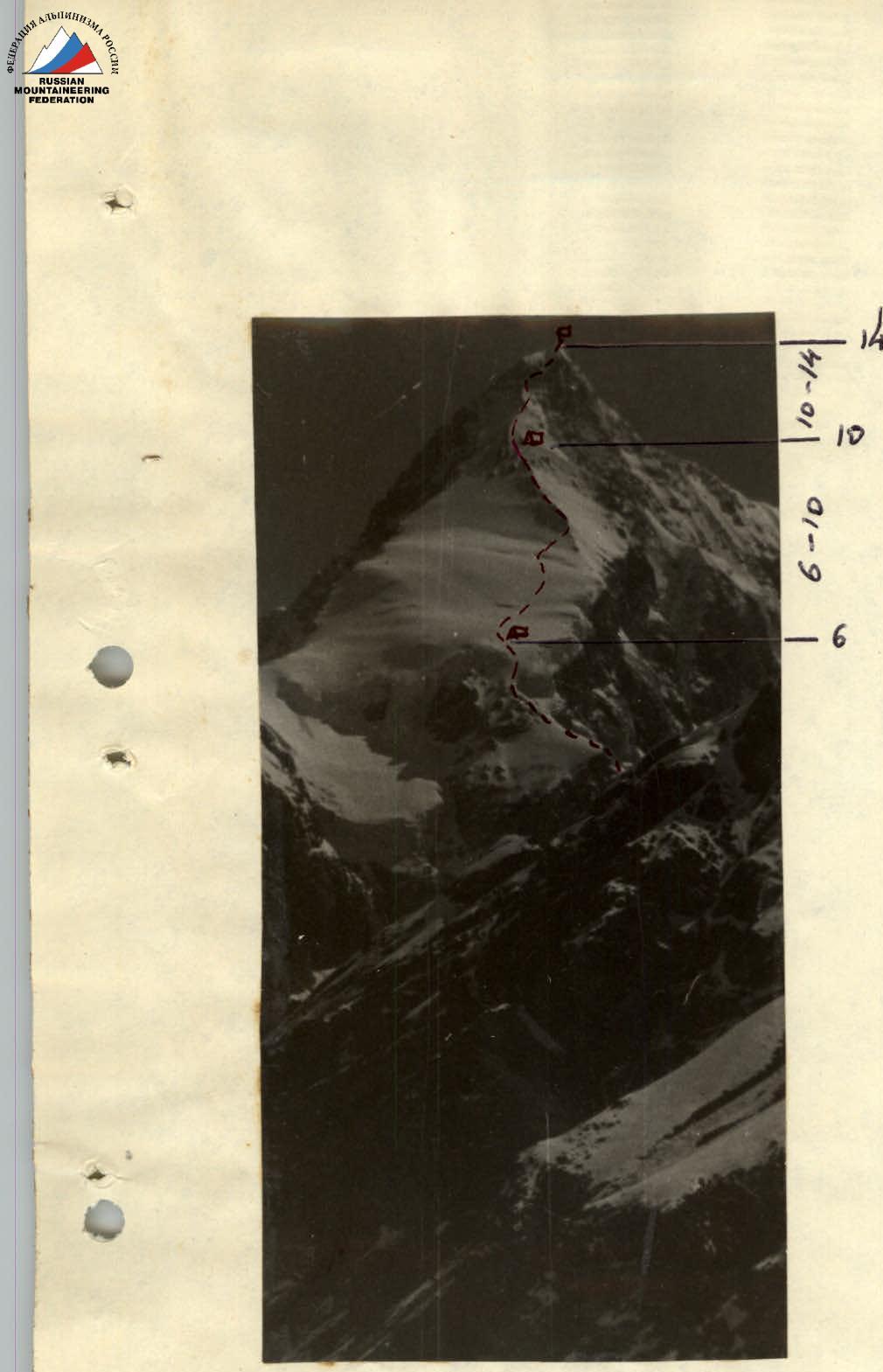
Photo 2. Southwest wall of Peak Dankov.
TABLE of main characteristics of the ascent route
Route — Southwest wall of Peak Dankov Height difference — 2380 m Including complex sections — 700 m Average steepness of the route — 60°
| Date and section number | Average steepness of the section | Length of the section | Characteristics of the section and conditions of passage: By relief character | By technical difficulty | By insurance method | By weather conditions | Time of departure and stop for bivouac | Number of moves, hours, and processing work | Number of pitons hammered: rock | ice | drill | Bivouac conditions | Weight of daily ration |
|---|---|---|---|---|---|---|---|---|---|---|---|---|---|
| July R1 | 55–60° | 600 m | snow, ice | medium difficulty | alternating | good | 8:00–18:00 | 10 | 5 | 3 | on a saddle | 1.0 kg for two participants | |
| R2 | 55–65° | 160 m | rocks in snow, ice | alternating, only through pitons | good | 18:00–20:00 | 2 | 12 | 5 | ||||
| July 30 (processed R2 traversed) | |||||||||||||
| R3 | 60° | 120 m | ice with snow | medium difficulty | good | 12 | |||||||
| R4 | 85° | 60 m | rocks Section 4: R5 - along a narrow ledge, 120 m to the left. Insurance was via pitons. The ledge led to a steep ice ridge (R6), 150 m up. Insurance was alternating through ice pitons. | ||||||||||
| R5 | along a ledge | 120 m | medium difficulty | ||||||||||
| R6 | 65–70° | 150 m | ice with snow | medium difficulty | alternating through ice pitons | good | 5:00–20:00 | 15 | 10 | on a slope | 3.0 kg | ||
| July 31 | |||||||||||||
| R7 | 40° | 200 m | snow | simple | simultaneously | — | — | — | — | — | — | — | — |
| R8 | 50° | 300 m | mainly ice | difficult | pitons, fixed ropes | — | 3 | 9 | |||||
| R9 | 45–50° | 400 m | rocks with ice | medium difficulty | pitons, fixed ropes | — | 12 | 1 | on a ridge | ||||
| R10 | 45–50° | 200 m | ice | medium difficulty | pitons, steps, fixed ropes | 8:00–19:00 | 11 | 7 | sitting | 3.0 kg | |||
| August 1 (processed R10 traversed) | |||||||||||||
| R11 | 50° | 200 m | ice | difficult | pitons, steps, fixed ropes | wind, blowing snow, thunderstorm discharges | 8 | ||||||
| R12 | 75–80° | 120 m | rocks | very difficult | pitons, ladders, fixed ropes | 18 | 3 | ||||||
| R13 | 60° | 90 m | ice | pitons, fixed ropes | 6 | ||||||||
| R14 | 30–40° | 160 m | snow, cornices | medium difficulty | through ice axe, fixed ropes | 8:15–00 | 7 | as on July 31 | 3.0 kg |
Descent followed the ascent route Team captain E. Ioakhim