Climbing Passport
- Climbing category — technical
- Climbing area — Central Tien Shan, West Kokshaal-Too ridge
- Summit — 5160 m (Vityaz peak) via NE ridge
- Planned — 5A category, first ascent
- Height difference — 1010 m.
Length of sections:
- 4th category — 425 m.
- 5th category — 460 m.
Average steepness:
- Main part of the route — 41°
- Entire route — 37°
- Pitons hammered:
- Rock — 10,
- Nuts — 7,
- Ice — 39
Left on the route:
- Rock —
- Nuts —
- Ice —
- Team's climbing hours — 18, days — 1
- Overnight stays — on the Juren glacier below the route
- Team leader: Monaenkov Evgeny Ivanovich — Master of Sports
Team members:
- Opoitsev Nikolay Anatolyevich — Candidate Master of Sports
- Lavrushchev Nikolay Alekseyevich — Candidate Master of Sports
- Pankov Vladimir Petrovich — 1st sports category
- Coach: Monaenkov Evgeny Ivanovich — 142101, Moscow region, Podolsk, 44-A Pleshcheevskaya st., apt. 17
- Route start: August 2, 1998; summit — August 3, 1998; return to base camp — August 4, 1998
- Alpinism Federation of Moscow region:
103050, Moscow, 22-B Tverskaya st., phone 299-97-67
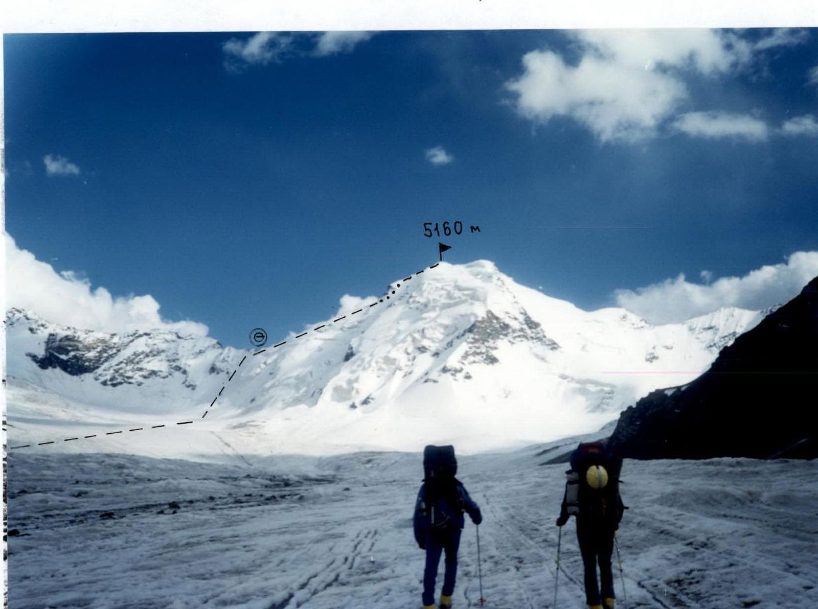
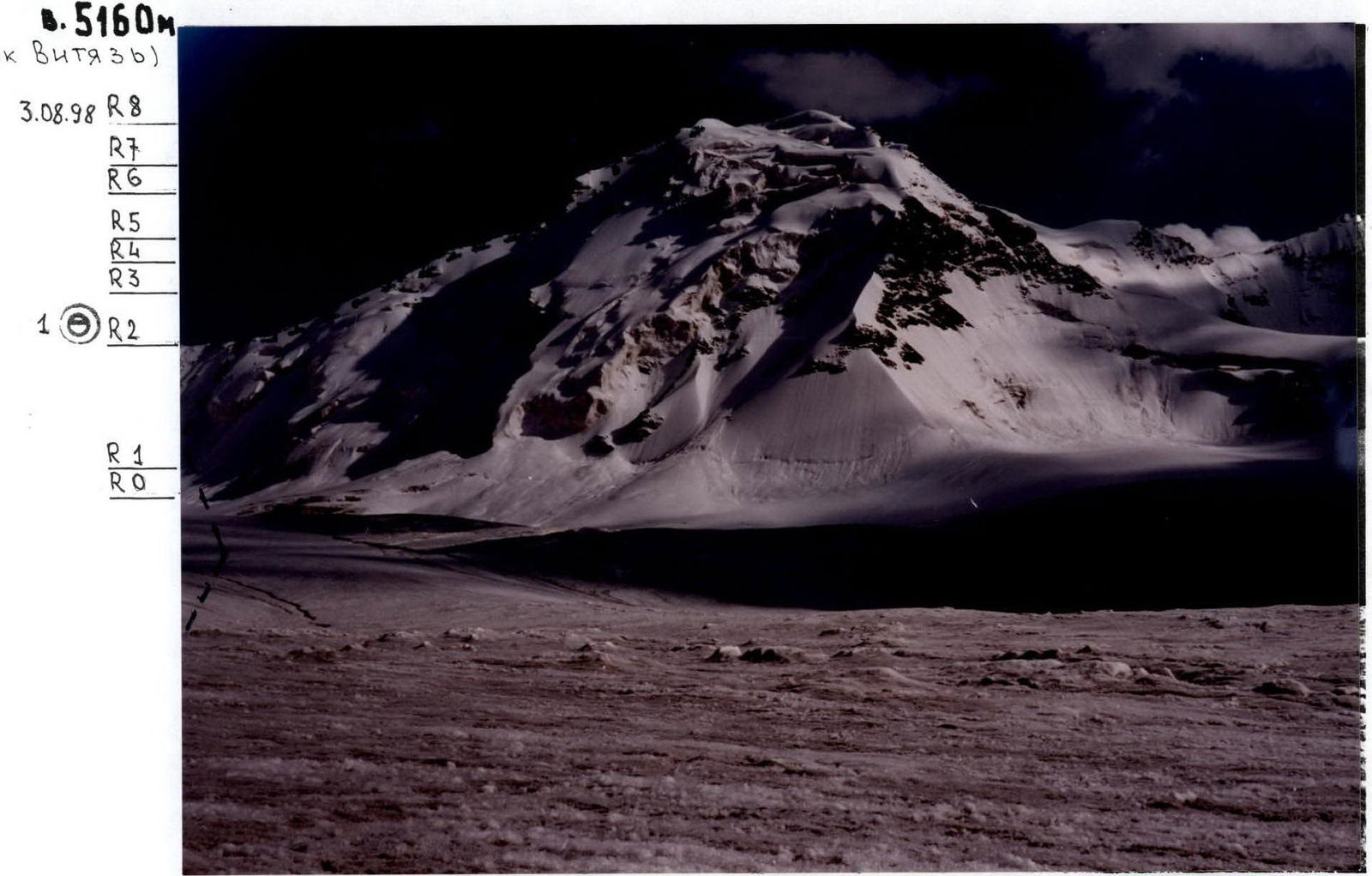
Team's route to peak 5160 m (Vityaz peak). Photo taken on approach on August 2, 1998
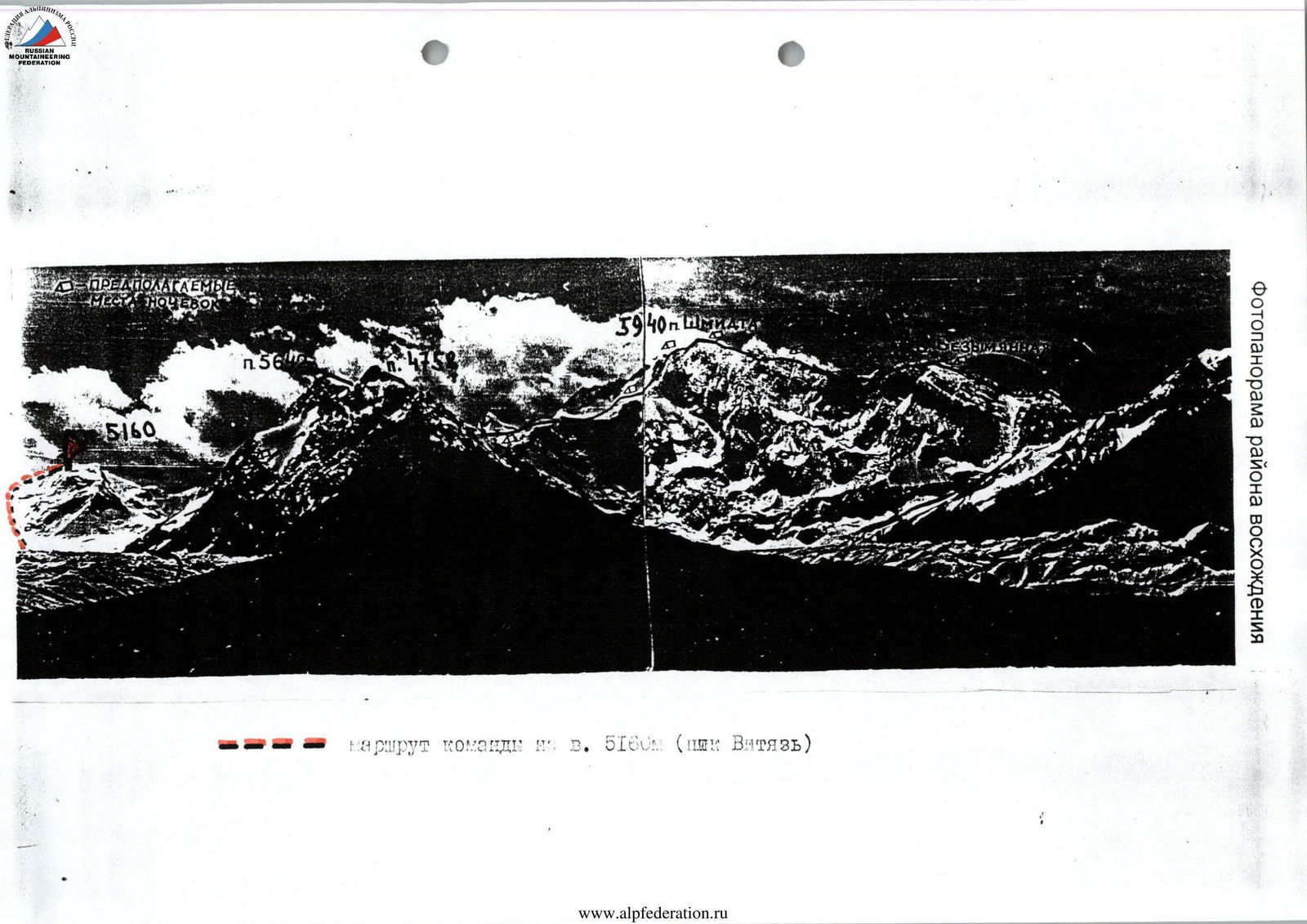
Photopanorama of the climbing area. Team's route to peak 5160 m (Vityaz peak).
Brief Overview of the Climbing Area
West Kokshaal-Too is the southernmost and highest ridge in the mountain range formed by several latitudinal ridges (Terskey-Alatau, Jetym, Borkoldoy) located in Central Tien Shan between Lake Issyk-Kul and the Takla-Makan desert.
To the north, West Kokshaal-Too is bounded by the Uzengi-Gush and Myurduryut-Aksai river valleys, to the west and east by the breakthroughs of these rivers through the main Kokshaal-Too ridge, and to the south by the Kokshaal river valley. This river system belongs to the Tarim river basin.
There are many peaks around 6000 m high in this area. The most interesting ones (from west to east):
- p. Kzyl-Asker (5842 m),
- Krylya Sovetov (5429 m),
- p. Shmidta or Kosmos (5954 m),
- p. Dankova (5982 m),
- p. Korolyova (5816 m).
By now, ascents have been made to p. Kzyl-Asker, p. Dankova, p. Korolyova, p. Alpinist. Of the four peaks conquered by climbers, two were ascended by climbers from the Moscow region (p. Korolyova and p. Alpinist).
The West Kokshaal-Too ridge is composed of sedimentary, metamorphic, and igneous rocks from the Paleozoic and Precambrian eras:
- schists,
- sandstones,
- limestones,
- marbles,
- gneisses,
- granites,
- syenites, etc.
The relief of most of the ridge crests is alpine. The ridge is characterized by a combination of typical alpine forms (many steep walls with a height difference of 1.5–2 km, with significant snow cover and powerful glaciation, which is second only to the Peak Pobeda glaciation in Tien Shan).
The snow line is located at altitudes of 4000–4500 m. River valleys have a fairly high absolute height (3000–3500 m). In many places, there are marshy areas even at altitudes of 3500–4000 m.
The climate is quite harsh. In summer, in the valleys, average monthly temperatures are 5–8 °C, and the average monthly precipitation is 20–30 mm. The weather is very unstable.
There is no permanent population south of the Naryn river. A small part of this area is used as temporary pastures. In the upper reaches of the Naryn river, intensive geological exploration is being carried out by a joint Kyrgyz-Canadian company. This company has built a good asphalt road from Lake Issyk-Kul to the gold mining site.
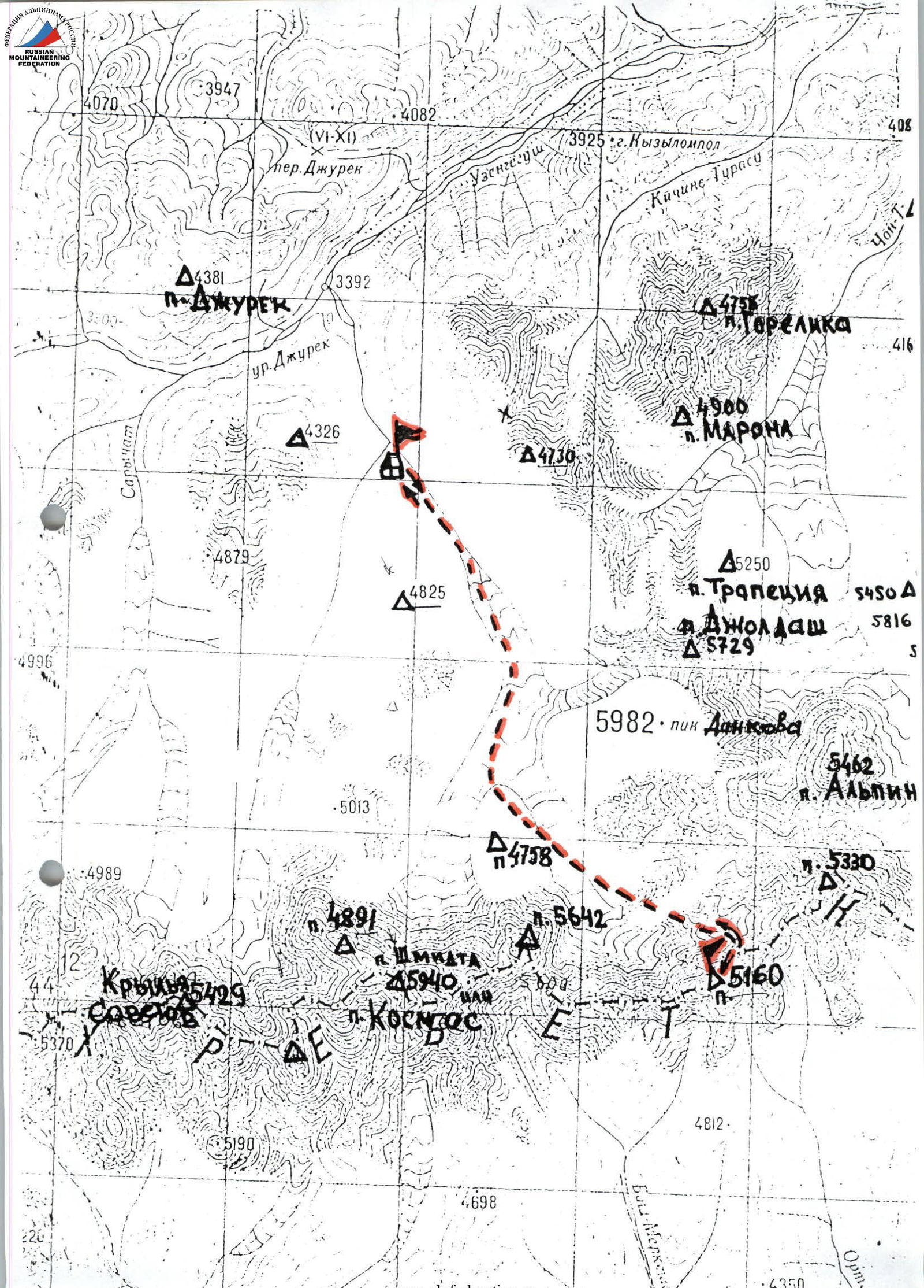
The Uzengi-Gush river valley is visited only by shepherds, hunters, tourists, and climbers. The approaches here along the trails are quite long and difficult. The simplest, but longest path is from the city of Naryn. The shortest, but most difficult path is from the Karasai settlement on the Naryn river bank. We chose our path from the Barskaun settlement on the shore of Lake Issyk-Kul, along an asphalt, and then a dirt road — mainly because we had pre-booked two vehicles (GAZ-66 and ZIL-131) to be waiting for us here. The entire journey by car to the base camp took us two days.
First, we moved along the Karanukus valley towards the Kubergenty pass through the Borkoldoy ridge. From this pass, a majestic chain of icy giants of the Kokshaal-Too ridge from p. Kzyl-Asker to p. Korolyova comes into view. From the pass, we turned east along the Katura valley. At the confluence of Katura and Jurek rivers, the road passes among fantastical mountains of bright red color, resembling Egyptian pyramids, castles with balconies, arches, and bridges in shape. The most significant of these is Kyzyl-Ompol (3926 m).
We set up our base camp on July 23, 1998, on a large, fairly flat clearing, above the confluence of two rivers flowing from two parallel valleys and merging into the Uzengi-Gush river. The left tributary originates from under the p. Dankova glacier, and the right one — from under the p. Krylya Sovetov glacier.
Team's Tactical Actions
On August 2, the team left the bivouac in the hollow under p. 5160 m at 12:40. Moving to the middle of the Juren glacier, we proceed along its right part, gradually transitioning to the center in the direction of the chosen unnamed peak 5160 m, which closes the gorge. The glacier is quite even and clean. On a small island covered with fine scree in the left part of the glacier, we leveled a platform for an overnight stay. We set up a bivouac at 18:00.
Two days were planned for completing the intended route, including descent, and one reserve day in case of bad weather. This plan was fulfilled.
While observing the route, we planned possible bivouac locations on the ridge. All bivouacs were planned to be lying on snow, which would contribute to good rest for team members, as confirmed during the descent.
Practically every team member had to lead on the route due to its high snow coverage, which demanded significant physical effort. Considering this feature of the route, the group hardly removed crampons during the ascent. The movement of rope teams on the ridge was simultaneous and alternating. When passing through a 350 m ice wall, we used:
- fixed ropes,
- insurance through ice axes,
- ice screws.
The group was evenly matched in physical fitness, thanks to regular joint training sessions.
During the ascent, a rescue team was stationed at the base camp, ready to respond in case of an emergency. Throughout the entire route, there was stable radio communication with the base camp and another team climbing a different mountain.
Throughout the ascent, the team strictly adhered to drinking and food regimes. There were two hot meals per day, in the morning and evening, at bivouacs, and snacking with hot tea from individual flasks. The food consumption per participant was 500 g.
There were no accidents or injuries during the ascent. According to the team members and the coaching council, the route taken is logical and safe. It can be recommended for groups climbing p. 5160 m (Vityaz peak) via the NE ridge for the first time, and it can also be recommended as one of the primary descent options from the summit when attempting new routes on p. 5160 m.
Route Diagram in Symbols
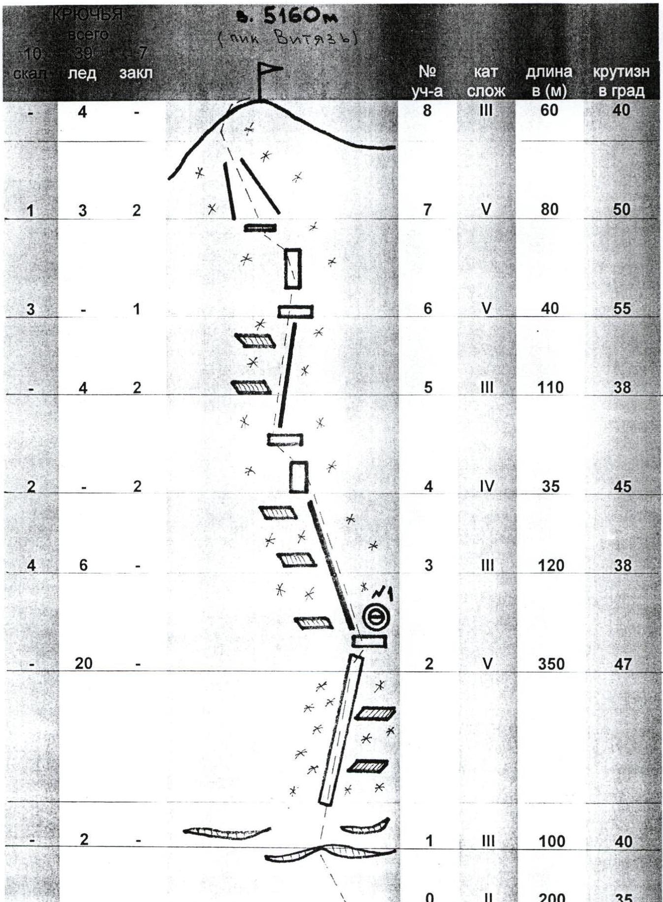
| Section № | Category | Length (m) | Steepness (°) |
|---|---|---|---|
| 8 | III | 60 | 40 |
| 7 | V | 80 | 50 |
| 6 | V | 40 | 55 |
| 5 | III | 110 | 38 |
| 4 | IV | 35 | 45 |
| 3 | III | 120 | 38 |
| 2 | V | 350 | 47 |
| 1 | III | 100 | 40 |
| 0 | II | 200 | 35 |
Note: the scale of the diagram is altered due to the considerable length and uniformity of the terrain along the route sections.
Route Description by Sections
August 3, 1998
Section R0–R1
From the bivouac, we moved simultaneously along a gentle glacier with closed crevasses towards a steep ice wall with a bergschrund leading to the ridge.
Section R1–R2
A steep ice-snow wall, 7 rope lengths long, with closed crevasses. Insurance was alternating through ice screws and ice axes. We reached a saddle on the snow-ice ridge, where there was a good platform.
Section R2–R3
From the platform, we moved straight up along the snowy, corniced ridge towards a destroyed rock wall. Insurance was simultaneous through ice axes. Caution was required due to cornices.
Section R3–R4
We bypassed the rock wall on the right, using piton insurance. The rocks were destroyed with ice and snow. The leader, N. Lavrushchev, passed through this section without removing crampons, reaching a flat platform.
Section R4–R5
From the platform, we moved straight up to a sharp snowy, corniced ridge leading towards the second rock belt. On the platform, we all gathered before a steep destroyed rock wall at 16:30.
Section R5–R6
Movement was along the destroyed rocks of the wall from right to left, towards an iced-up couloir, with piton insurance. Around 17:40, snow grains started falling.
Section R6–R7
The route traversed left of the rock wall along a steep ice couloir. There were "live" stones frozen in ice and sections of formed ice. Insurance was through ice screws and rock pitons. At the top of the couloir, we exited right-upwards onto a steep snow slope leading towards the summit.
Section R7–R8
Two rope lengths along a steep snow dome to the summit. There was a strong wind from the direction of China. We reached the summit at 18:00, took photos, and began descending along the ascent route at 18:30.
On the platform under the rock wall, we built a cairn since the summit was snowy and there was no place to leave a note.
At 20:00, we descended to the exit point on the snow ridge, where we dug out a platform in the snow and ice for a tent. This took at least 1.5 hours.
On August 4, we descended to the base camp.
Peak 5160 m (Vityaz Peak)
Technical photograph of the route
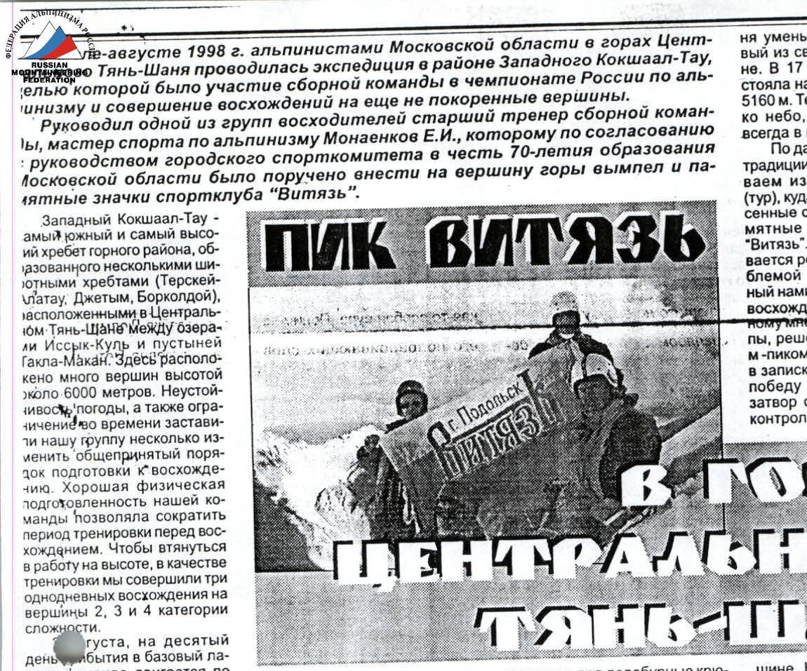
Vityaz Peak
What could be more interesting than a first ascent, climbing a path never before taken, unexplored! And this is one of the most attractive aspects of mountaineering. The path ahead for the team was not easy. The lower part, a steep ice wall, and the upper rock belt leading to the summit, looked particularly challenging. It was so steep that the rocks were almost snow-free. Whether we could overcome these obstacles was the eternal question for climbers.
Early in the morning on August 3, a team of Podolsk climbers, consisting of the author of these lines, as well as Candidate Masters of Sports N. Lavrushchev and N. Opoitsev, and first-category climber V. Pankov, set out on the ascent. The path went from the overnight stay on the medial moraine along the Jurek glacier to the start of the route. It was quiet and cool. If we were asked at that time what weather we would prefer for the ascent, we probably wouldn't have been able to decide between warm and sunny or cold and snowy.
- Warmth and sun would have made the movement, especially on ice, into a sufficiently difficult task.
- Cold with snowfall would have complicated the progress along the steep, destroyed rocks of the summit tower.
Which was confirmed during the route.
The ice wall, covered in ice, loomed closer and closer from the very start of the route. We put on crampons from the beginning. The 350-meter lower part of the 55° ice wall, up to the exit onto the ridge, was climbed with alternating insurance, screwing ice screw pitons into the ice. Then we reached the ridge. After a short rest and some photography, we continued along the rocky, partly snowy, corniced ridge towards the pre-summit tower. Upon reaching the rocks on the ridge, we found them to be heavily destroyed. Therefore, we had to proceed with more thorough piton insurance.
The pre-summit tower consists of heavily destroyed reddish rocks with a chevron structure. Attempts to hammer rock pitons into them were unsuccessful. To start ascending the rocks, the first climber, N. Lavrushchev, hammered an ice screw — a "karovku" — deeply between the ice and rock. Only then, having secured himself with reliable insurance, could he proceed onto the steep snow-ice dome leading to the summit of peak 5160 m. In the first steps on the rocks, the team still felt that respectful fear that the mountain inspires. But the voice of the first climber became firmer, commands were given more clearly: "Pay out the rope! Pay out more! Secure!" And he climbed higher and higher, diminishing in the eyes of his teammates, merging with the rocks. The partner in the rope team soon shouted, looking up: "Five meters left!" — and tensely waited for a response. Then, from above, came an exhausted: "Done," — and everyone suddenly realized that the pre-summit tower was passed.
Gradually, the steepness of the ridge decreased. And soon, the first in the rope team was already on the summit. At 17:00, the entire team stood at the highest point of peak 5160 m. Now, only the sky was above us, as it always is in the mountains.
Following the old mountaineering tradition, we built a pyramid (cairn) from stones on the summit, into which we placed a pennant and commemorative badges brought with us from the sports club "Vityaz". Above the summit, the Russian flag with the "Vityaz" emblem, which we had carried through all the difficulties of the ascent, was raised. By unanimous decision of the group participants, it was decided to name peak 5160 m "Vityaz Peak", which we wrote in a note marking our victory over the mountain. The camera shutter clicked, capturing control shots on the summit. But soon, clouds moving from the direction of China covered the sky. A chill blew from the gloomy mountain giants, which suddenly became harsh and grim. It was time; we couldn't stay on the summit any longer; it was time to descend. It was too early to congratulate each other on our victory; ahead lay a long and dangerous descent, and everyone was already quite tired. Snow began to fall, making it dangerous and difficult to move along the ridge. Visibility was 10–15 m. Therefore, the group members descended very cautiously. We decided to set up a bivouac on the platform at the exit onto the ridge. At 21:00, tired but happy and proud of our victory, we approached the exit onto the ridge, where we found a small sloping platform. We cleared it of ice and snow, set up a tent. There was just enough room to sit or, at best, lie semi-reclined. We all climbed inside, scooped up snow into a pot, cooked, ate, and drank. The night passed calmly.
Only the next day, by organizing eight sporting descents on ropes, did we descend down the path of our ascent along the ice wall.
E. Monaenkov, team captain, Master of Sports.
In the photo: team members on the summit. N. Lavrushchev and N. Opoitsev are standing, V. Pankov and E. Monaenkov are sitting.
Podolsky Rabochy newspaper, November 14, 1998