I. Technical Class
- Tian-Shan, Kyrgyz Range
- Pik Svobodnaya Korea, 4777 m, via North Face (Semiletkin's route)
- Difficulty category 6B
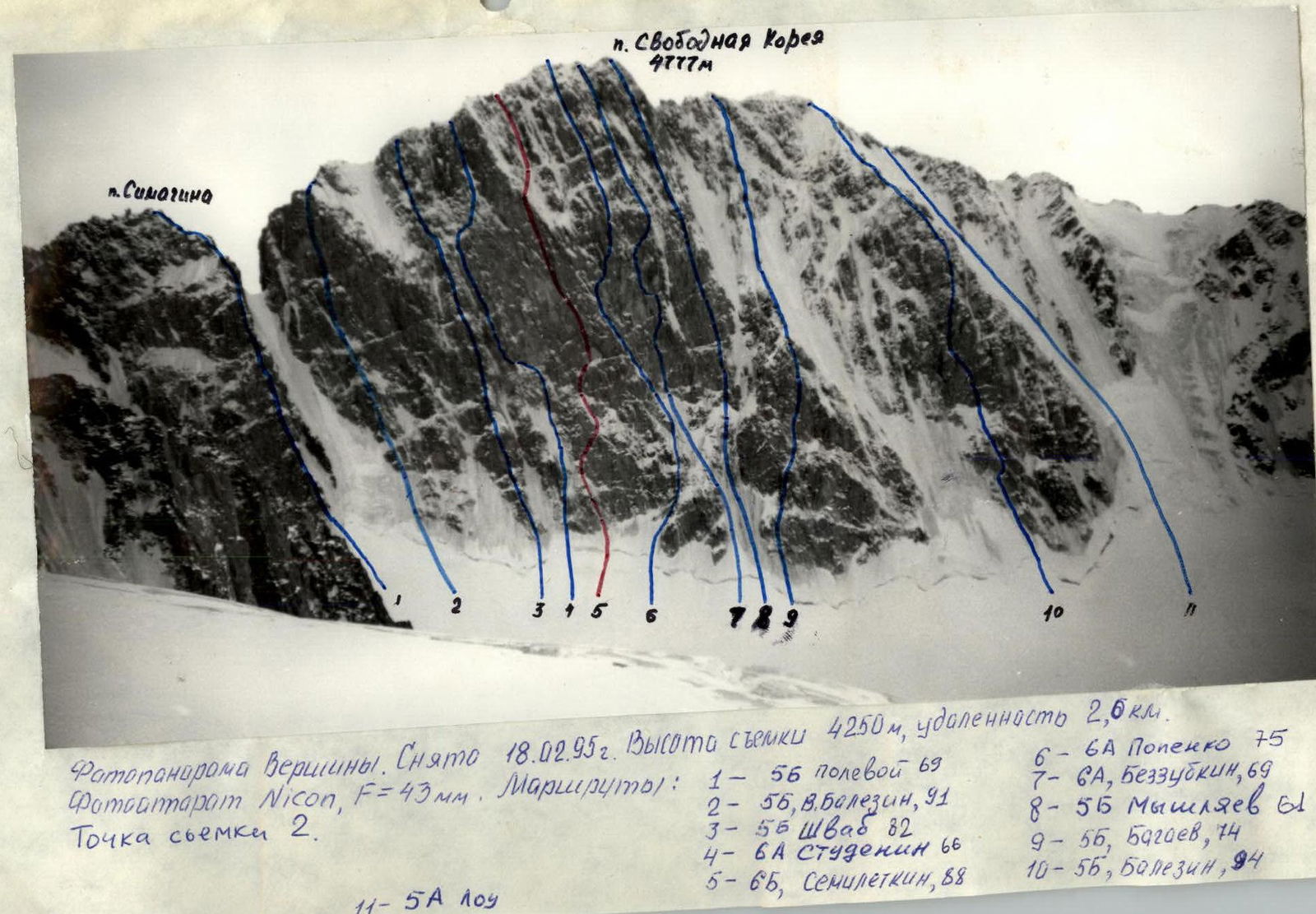
- Elevation gain 677 m, length 1060 m, average steepness of the main part of the route 67°, including 6B category difficulty at 85° (4320 m – 4570 m)
- Pitons used: rock 142/74, bolted pitons 104/40, ice screws 44/2
- Climbing hours 48, days 7 (including preparation)
- Overnight stays: five nights in a tent on a platform
- Team leader: Balyezin Valery Viktorovich, International Master of Sports
Team members:
- Zakharov Nikolay Nikolayevich, International Master of Sports
- Kokhanov Valery Viktorovich, Master of Sports
- Bakaleinikov Evgeny Dmitrievich, Master of Sports
- Obednin Konstantin Alexandrovich, Candidate Master of Sports
- Kozyrenko Evgeny Viktorovich, Candidate Master of Sports
- Coach: Zakharov Nikolay Nikolayevich
- Departure for the route February 22, 1995
Reached the summit February 27, 1995
Returned February 28, 1995
- Organization: Krasnoyarsk Kraysportkomitet
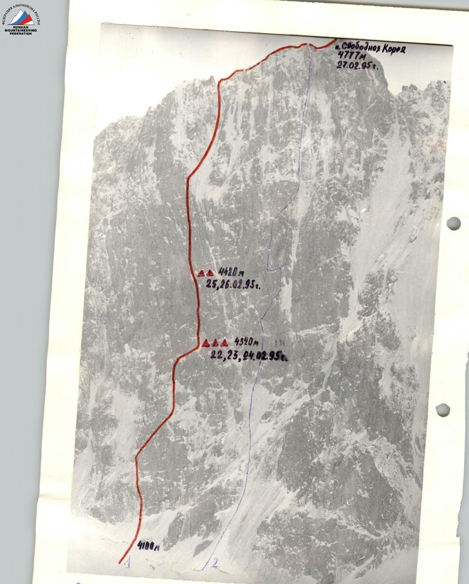
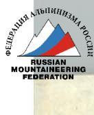
Photo of the route taken on February 20, 1995: at 14:00, distance 2 km, altitude 4300 m, Nikon camera, F-43 mm.
- 1 6B Semiletkin's route
- 2 6A Bezzubkin's route
Tactical Actions of the Team
According to the tactical plan, the route processing (R0–R5) was carried out by the pair Kokhanov–Zakharov on February 21 from 12:00 to 16:00. On February 22, the team started the route in full composition and covered the section R5–R8. Then the pair processed about 30 m of the wall, while the rest of the team worked on setting up an overnight stay. On February 23, the pair Obednin–Kozyrenko processed a large cornice (R9–R10) and the slab after the cornice. On February 24, the pair Balyezin–Bakaleinikov processed the section R10–R11 and the beginning of R11–R12. On February 25, the team ascended to the planned overnight location (R11) in full. The pair Obednin–Kozyrenko continued processing the section R11–R12, while the rest of the team set up the overnight stay and hung a platform. On February 26, the pair Balyezin–Bakaleinikov processed the sections R12–R16. On February 27, the team traversed the processed sections, the ice section of the "roof," the pre-summit ridge, and reached the summit of Pik Svobodnaya Korea at 17:20. The team spent the night on descent and descended via a 5A category difficulty route on February 28, 1995.
The route was completed with all safety measures observed; there were no injuries or falls. The overnight stays were safe, protected by overhanging rock walls. Excellent equipment, good nutrition, and team preparation allowed the team to complete the route with a reserve of physical and mental strength.
Weather conditions:
- from February 21 to 25 – severe frost in clear weather,
- February 26 – gusty side wind,
- February 27 – weather deteriorated, strong wind with snow.
Throughout the ascent, the team maintained reliable radio contact with the rescue team and a radio operator from the Main Directorate for Emergency Situations.
When traversing the main wall (R8–R16), "sky hooks" and rock anchors were widely used for ITO, which increased the speed of the route.
Food Supply Table
- Fried meat 2 kg
- Crackers 2 kg
- Sugar 1 kg
- Tea 0.2 kg
- Freeze-dried soups 0.5 kg
- Lard 1 kg
- Condensed milk 3 kg
- Bouillon cubes 0.2 kg
- Coffee 0.1 kg
- Buckwheat 0.5 kg
- Sweets 1 kg
- Salt 0.1 kg
Petrol 2.5 kg Gas 0.8 kg
Total: 14.9 kg
The weight of each backpack at the start of the route was about 13 kg (excluding equipment hung on the route).

Total climbing hours 48
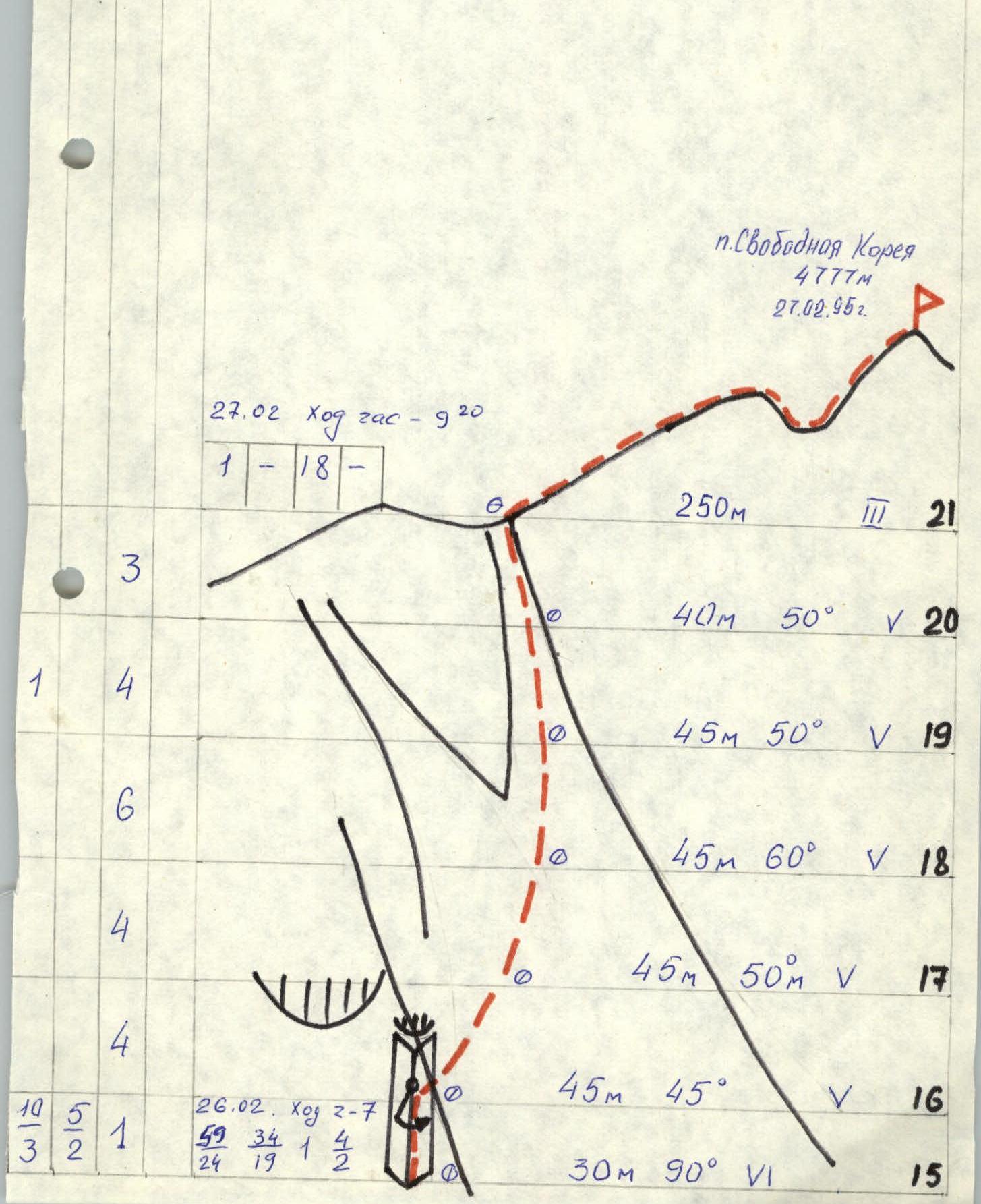
Route Description by Sections
R0–R1. Initially, a 2 m bergschrund, followed by an ice slope. R1–R2. Ascent via icy and snow-covered rocks and gullies into an ice-filled couloir. R2–R3. Ice slope. R3–R4. Ice slope with an exit to a snow-covered rocky corner at the end. R4–R5. Snow-covered rocky internal corner. R5–R6. Steep ice slope with a steepness of about 65°. R6–R7. Initially an ice slope, then a vertical chimney. R7–R8. Internal corner leading to an inclined, snow-covered and icy ledge under the "TV." On the right edge of the ledge, a planned site for setting up a platform for overnight stays. R8–R9. Sheer wall with a sloping leftward crack with loose rocks. Climbing is mostly on ITO. Approach to the cornice. R9–R10. Large cornice about 4 m, traversed on ITO, with a control cairn on the cornice. After the cornice, a steep slab, followed by inclined leftward cracks. R10–R11. Inclined leftward cracks, then an internal corner. At the end of the section, an exit onto a large boulder covered in ice. On the ice, a spot for hanging a platform for overnight stays. R11–R12. Sheer, destroyed wall with large loose blocks. Climbing is very difficult, mostly on ITO. General direction is upwards and leftward under a small rocky cornice, which is traversed "head-on." Exit into an internal corner. R12–R13. Initially leftward along the destroyed wall, then along the internal corner. R13–R14. Continuation of the overhanging internal corner, followed by an exit onto inclined slabs heavily covered in snow, making it difficult to organize protection. Reception point under a cornice at the start of a large internal corner. Control point. R14–R15. Large sheer internal corner with a wide crack. R15–R16. Internal corner ends in a cornice, from under which a pendulum swing rightward along the destroyed wall, followed by climbing rightward to an exit onto ice. R16–R18. Ice slope with a steepness of about 50°. R18–R19. Ice gully with a steepness of 60°. R19–R21. Ice gully with rock outcrops, steepness about 50°, exit onto the main ridge of Pik Svobodnaya Korea. R21–R22. Rocky-snowy ridge, exit to the summit.